Knebworth Neighbourhood Plan 2019 - 2031
10 Policies - Traffic, Transport and Parking
(1) 10.1 Introduction
Knebworth village is fairly well served by road, rail and bus services. The village centre lies along the B197, a secondary road that links Stevenage to the north and Welwyn Garden City to the south. The village is linked to Old Knebworth and villages to the west by Park Lane and to the east and Hertford by Watton Road. The railway from Knebworth Station provides services to Stevenage (for Peterborough and the North) and Cambridge, Welwyn Garden City and London. Buses link the village with Stevenage, Welwyn Garden City and less frequently with Luton and Hertford. There are some segregated footpaths within the village but generally pedestrians, cyclists and people with disabilities and mobility problems are not well catered for, particularly linking west and east of the railway. The majority of working residents commute to work; the 2016/17 survey showed that 47% use car, 42% use rail, 5% use bus, 2% cycle (Knebworth Parish Council, 2019).
Amongst the traffic and transport concerns of the villagers are:
- congestion in the 'high street' i.e. Insufficient road width for bi-directional flow between parked vehicles.
- minimal village-centre off-street parking.
- railway commuter parking in residential roads.
- peak period through traffic using B197 as an alternative to the A1(M).
- the lack of disabled access to the rail station platforms.
- sub-standard pedestrian access under the railway bridges.
The Objectives that were developed from the Knebworth Neighbourhood Plan Vision Statement and which led to the development of the Traffic, Transport and Parking Policies were:
- Find a solution to the 'high street' traffic and parking problems
- Negotiate for the provision of disabled access to rail station platforms
- Support and encourage use of sustainable modes of transport including ensuring access roads through new developments are suitable for bus routes and prioritise active travel
In addition, several objectives related to other topics refer to improved accessibility for all, which is also an objective of this topic.
The long-term effect of COVID19 is impossible to predict. It is probable that there will be a substantial increase in working from home and a reduction in travel both by personal transport and public transport. Also, there could be more local journeys by walking and cycling. However, the Transport, Traffic and Parking Policies in this Neighbourhood Plan will still apply.
(2) 10.2 Policy KBT1 Sustainable Modes of Travel
KBT1 Sustainable Modes of Travel
Developers should consider transport issues throughout the village from the earliest stages of development proposals so that:
- opportunities to promote walking, cycling and public transport use are identified, pursued and integrated with any existing village routes, and
- the needs of people with disabilities and reduced mobility for all modes of transport are addressed.
The reduction of dependence on private, particularly fossil-fuelled cars is supported.
Development proposals should give people the choice of travelling by means other than private car; should encourage the use of sustainable transport and; should provide or facilitate the provision of electric car charging points, car-pools, and bus services within and between new developments, rail station and village car parks.
The Government's revised National Planning Policy Framework (NPPF, Feb 2019, p. 30 & 32) states (in Sections 102, 104 and 110) that transport issues should be considered from the earliest stages of development proposals so that opportunities to promote walking, cycling and public transport use are identified and pursued. Also applications for development should give priority first to pedestrian and cycle movements, both within the scheme and with neighbouring areas, address the needs for people with disabilities and reduced mobility in relation to all modes of transport and create places that are safe, secure and attractive which minimise the scope for conflict between pedestrians, cyclists and vehicles. This hierarchical approach is supported by Hertfordshire County Council's Local Transport Plan 4 (LTP4) (HCC, 2018, p. 45) and North Herts District Council (NHDC, 2017, p. 51 & 52).
If the NHDCLP is implemented then Knebworth's population could grow by 30% by 2031, almost 50% greater growth than the average for Hertfordshire (21%). With new development will likely come a growth in car usage. As the NHDCLP proposes no additional employment in Knebworth, commuting to work from the village is also likely to increase.
HCC Travel Plan (HCC, 2018, p. 26) predicts that car trips in peak periods will increase by 17%-18% across the county. It is probable that this increase could be higher in Knebworth, particularly as Knebworth has one of the highest rates of car ownership in North Hertfordshire (NHDC, 2017, p. 40)
Given the local traffic congestion in the village 'high street' in peak periods and when there are problems on the A1(M) and also the parking problems around the village, the Parish Council supports proposals that encourage change of travel mode away from the private car to more sustainable forms of transport. This accords with NHDC Transport Strategy policy of ensuring new developments have sustainable transport "built-in" (NHDC, 2017, p. 51)
The community aspiration is that new development should positively encourage the use of sustainable forms of transport. A switch to walking and cycling may be encouraged by improving the safety and quality of existing routes and facilities. Both forms of movement would benefit from safer links across the railway. Cycling should be encouraged if a safe link could be provided to join up with the segregated cycle network in Stevenage and with National Cycle Route 12 which currently passes to the west of the village. Diverting some buses through new residential developments and to the rail station in peak hours may encourage greater use of both transport forms and reduce rail commuter parking. The provision of electric car charging points and shared mobility solutions is supported by HCC (HCC, 2018, p. 53) and NHDC.
(3) 10.3 Policy KBT2 Traffic Impact
KBT2 Traffic Impact
Developments should not significantly add to traffic congestion in the village, or to motor vehicle flows on rural lanes, and should provide good pedestrian, cycle and bus connections into Knebworth and the wider area and improve the existing pedestrian and cycling infrastructure.
Proposals for the development of any of the sites KB1, KB2 and KB4 must provide traffic assessments that consider the cumulative impact of all three development sites, both during construction and on completion, upon key routes, junctions and rail crossing points for all users, including pedestrians, cyclists and people with mobility problems, and secure necessary improvement measures.
Any other large development proposals (10 or more properties) in the village and surrounding rural area must provide a traffic assessment of its impact, both during construction and on completion, on the highways in the Neighbourhood Plan area.
Funding for the rail crossing point improvement measures is to be secured, and where practicable the measures are to be implemented, before any properties in the developments of KB1 and KB2 is occupied.
Funding for any necessary improvements to the key junctions is to be secured, and where practicable the improvements are to be implemented before the developments of KB1, KB2 and KB4 are occupied.
The National Trip End Model predicts a 17% increase in traffic on Hertfordshire's roads between 2015 and 2031 (HCC, 2018, p. 26). It is recognised by HCC and NHDC in their Transport Plans that the B197 acts as an alternative route for traffic avoiding the regular congestion on the A1(M). This situation is exacerbated when accidents or breakdowns occur on the motorway. NHDC state that their modelling shows that even with the introduction of a Smart Motorway system between junctions 6 and 8 of the A1(M), there is likely to be some increased traffic through villages such as Knebworth (NHDC, 2017, p. 82).
Currently the local congestion caused by on-street parking in the 'high street' may act as a deterrent to some motorists using the B197 to avoid the A1(M). However, if this congestion is removed, positive traffic management measures should be introduced to slow down and restrict through traffic to maintain safety for pedestrians and cyclists. A smooth flow is desirable to minimise pollution.
Several of Knebworth's secondary roads (Deards End Lane, Swangleys Lane, Gypsy Lane and the eastern section of Watton Road are rural in nature and layout and pedestrians, cyclists and motor vehicles share the narrow carriageways. The Parish Council broadly supports HCC's Local Transport Plan 4 policy that where new developments occur the related transport infrastructure should be designed and implemented with the aim of maintaining the existing character of the area, avoiding instances of community severance and maintaining residential and rural characters of the adjoining area (HCC, 2018, p. 53 & 54).
In proposals for the development of KB2 and KB4, the opportunity should be taken to utilise existing narrow country lanes (Gypsy Lane and Old Lane, respectively) as pedestrian/cycle routes (plus vehicular access to existing dwellings) and provide separate routes for carrying traffic to/through new developments.
As the NHDCLP chooses to treat development in Knebworth piecemeal (unlike the treatment of other communities in North Herts with a potential total increase of over 500 properties e.g. Royston, Hitchin, Baldock), the Parish Council strongly contends that the traffic implications of the total proposed developments should be assessed and that each developer should contribute proportionately to an overall Community Infrastructure Levy (CIL) or section 106 contribution, to fund ameliorative measures. This approach is supported by AECOM (AECOM, Feb 2019, p. 57). As is the requirement that developers provide a Transport Assessment / Transport Statement and Construction Environmental Management Plan for each site at the planning stage. The NPPF also requires developers to provide a Travel Plan and Transport Assessment so that the likely impact of their proposals can be assessed, (NPPF, Feb 2019, p. 32).
The village to the west of therailway line is very poorly linked for pedestrians and cyclists. At both rail under bridges single sub-standard footways adjoin narrow carriageways which have blind bends on their approaches. There is insufficient footway width for pedestrians to pass (DTp & CLG, 2007), (AECOM, Feb 2019, p. 24) and substantial numbers of commuters pass under the Station Road bridge. Currently all children walking to and from the primary school from the western part of the village need to use these routes. Alternate direction traffic signal controlled vehicular traffic would allow for the footways to be widened and would be safer for cyclists. Alternatively, extending Knebworth station's pedestrian subway to Kerr Close may improve pedestrian safety and allow the widening of the roadway under the bridge.
The northern footway of Park Lane from KB1 site boundary to the station is narrow in sections and will require improvement to safely cater for the expected increase in pedestrians from the proposed new development. Similarly, the access to the existing Primary School needs improvement to reduce the potential conflict between school children on foot or cycles and vehicular traffic using Swangleys Lane, particularly those children walking from dwellings in KB4. Alternatively, provide a new access to the Primary School, from within the southern part of KB4, removing, or minimising access from Swangleys Lane.
HCC's policy with regard to accessing rail travel is that rail users should be encouraged, where feasible, to use sustainable transport modes for the "last mile" of their journey to access stations, principally bus, cycling and walking (HCC, 2019, p. 10). In the KNP Action Plan, item 10 seeks to obtain land on the edge of the village for rail commuter parking to accommodate additional commuters from proposed developments in Codicote and Woolmer Green, thus reducing demand for on-street parking near the station.
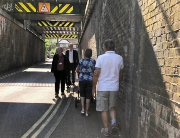
Figure 60 Pedestrian congestion under railway bridge
The community aspiration is that new developments should cause minimal traffic disruption during construction and, when completed, should improve existing conditions at known problem locations in the village to the benefit of all current and future residents of the village.
(1) 10.4 Policy KBT3 On Street Parking
KBT3 On Street Parking
Development proposals should minimise on-street parking on residential roads, and increase off-streetpublic parking in the village centre, or provide off-street railway commuter parking, if possible.
All types of developments are expected to meet the NHDC's minimum off-street parking provision. Any proposals that do not meet these standards will not be supported, neither will developments which add to the burden of on-street parking, or which encourage parking on footways.
On street parking, impeding the traffic and pedestrian flow on residential roads, is a continuing and very emotive issue in the village. Conversely, the viability of the village centre businesses is dependent on having sufficient on and off-street parking for customers and employees. Getting the right balance between free and charged-for parking is an ongoing problem. Free limited time parking in the 'high street' helps the businesses and maintains traffic at a safe speed for pedestrians to cross, but sometimes impedes traffic flow. The KPC continues to seek an acceptable solution with NHDC/HCC.

Recent surveys show that rail commuter parking occupies most of the available space in the residential roads within 400 metres of the station during weekdays (Knebworth Parish Council, 2019). The station car park only has 48 charged for spaces which are usually fully occupied. Rail passenger numbers are predicted to increase by 40% by 2040 (Network Rail, 2018) therefore, it is likely that the demand for long stay car parking will increase accordingly. Incentives to encourage car sharing by rail commuters and the diversion of some bus services through new developments on the edge of the village to stop at the station at peak rail usage times may ameliorate this problem. Expanding the controlled residential parking zones should be investigated. This could reduce this inconvenience to residents, but it could also lead to rail commuters parking in more distant parts of the village or moving to other stations thus reducing the usage and eventually the viability of Knebworth station. The provision of some dedicated, long stay, off-street parking funded by developers' contributions would also help.
The community aspiration is that there is a reduction in the amount of obstructive and obtrusive on-street parking in residential roads. The provision of sufficient suitable off-street parking to cater for rail commuters and for 'high street' shoppers would contribute to achieving this aspiration.
(2) 10.5 Policy KBT4 'High Street' (London Road) Traffic Issues
KBT4 'High Street' (London Road) Traffic Issues
Developer contributions will be sought to fund a formal study, with the aim of providing the optimum solution for the 'high street' (London Road) to:
- Reduce the potential for accidents and damage, for both parked and through traffic;
- Enhance the safety of pedestrians and cyclists and;
- Retain sufficient on-street parking to support local businesses.
Congestion in the 'high street' and peak period traffic using the B197 to avoid the A1(M) are already major concerns to villagers. Since HCC LTP4 predicts that car trips in peak periods will increase by 17%-18% across the county (HCC, 2018, p. 26), the situation is unlikely to improve without positive remedial action.
Traffic congestion in the village 'high street' during peak periods and at times when there are problems on A1(M), is such that the risk of, and actual, damage to vehicles is increased, and through-traffic diverts into parallel, unsuitable, residential village roads to avoid the delays. Additionally, the emissions, noise and density of the congested traffic makes the 'high street' a less attractive place for pedestrian shoppers. The community aspiration is to increase the safety and attractiveness of the village's 'high street'.

Figure 62 Queuing traffic coming from Stevenage (left) and in the 'high street' (right)
Conversely, the implementation of temporary traffic lights in November 2018, and reduced parking in the 'high street', caused significant tailbacks at either end, substantially increased speed through the 'high street' and had a marked negative impact on 'high street' businesses, as much of their business is from 'passing, non-local' trade en route to Stevenage, Welwyn, and beyond.
The primary school, and the combined library, dispensing chemist and the new doctors' surgery are all to the east of the 'high street', whilst the bulk of the proposed new housing is to the west of the 'high street', thus increasing the expected amount of pedestrian movement across the 'high street' and the potential conflict with vehicular traffic.
The NPPF paragraph 106 states that local authorities should seek to improve the quality of parking in town centres. (NPPF, Feb 2019, p. 31). Hopefully a study, financed by developers, will produce a workable solution that is practical, and is acceptable to businesses, residents and road users.
A longer-term solution may be to widen the 'high street' to meet national planning design guides for carriageway, pavement and parking bay widths (CLG, 2019). As frontage properties are developed in future the building line should be brought back to be at least 7 metres from the existing carriageway centre to allow continued social distancing on the pavement.
(1) 10.6 Policy KBT5 Bus Routes
KBT5 Bus Routes
Developments should provide a suitable route for public service buses through developments on sites KB1 and KB2, so that no dwelling is more than 400 metres from a bus stop.
One of the objectives is to encourage people to change from private cars to using public transport. This is more likely to happen if the distance to a bus stop is relatively short. The Institution of Highways and Transportation suggests 400 metres maximum convenient walking distance to bus stops in an urban context (Guidelines for Providing Journeys on Foot, 2000), (AECOM, Feb 2019, p. 24). Diverting the current service (44/45 Luton – Stevenage) through proposed developments on KB1 and KB2, at least at peak rail usage times, would provide public transport to the rail station and village centre. There may be scope to combine future Section 106 funding for developments planned for Codicote, which is also served by the 44/45 to pay for service enhancements to this route.
The community aspiration is that new and existing properties should be within a convenient walking distance of regular bus services, that serve the station and village centre and link the village with neighbouring towns.