Ickleford Neighbourhood Plan 2022 - 2035 Submission Version March 2023
(1) 13. Annexes
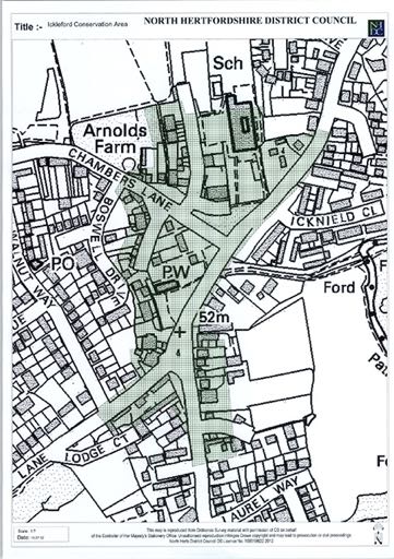
Annex 1: Ickleford Conservation Area
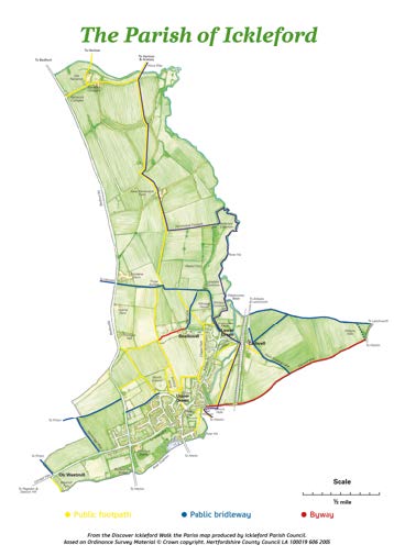
Annex 2: Ickleford Footpath Map
Annex 3: Viewpoints
Reproduced from Ickleford Design Codes. AECOM May 2022
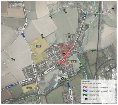
Viewpoints
The Conservation Area Character Statement issued in November 2019 by the District Council identifies the following key views within Ickleford Conservation Area:
1) View north up Turnpike Lane from southern boundary of Conservation Area.
2) View of village green from junction of Arlesey Road and Chambers Lane, looking west.
3) View from Chambers Lane, looking south-east from exit of Conservation Area.
4) View looking north along Arlesey Road from the junction of Arlesey Road and Turnpike Lane.
A number of additional views, views 6 to 8, have been considered of value, they relate to the perception of the village when approaching it from the surrounding countryside. Some additional views, views 9 to 17, have been considered of value in relation to the perception of nature, water and village when observed from paths in the surrounding landscape
Annex 4: Important Nature Conservation Sites
Site Name & Code: Oughton Head (11/001)
Area (ha): 25.26
Description: Oughton Head consists of the main area of common in the south-east and the Wildlife Trust nature reserve to the north. The common supports marshy grassland with fen but with drier areas of neutral grassland, scrub and woodland. An unusual geology has resulted in a very diverse flora. Mixed wet woodland forms a belt of varying width along the north bank of the River Oughton which has its source at the western end. The site is one of the larger fen woodlands in Hertfordshire and has a long history of being managed as a fen. The western sections are dominated by mature Alder (Alnus glutinosa) carr (an unusual habitat in Hertfordshire). The river itself supports aquatic plants of note, the remnant fen components are notable within the county and the area is important for a range of invertebrates, amphibians, reptiles, birds and mammals, with Grass Snake (Natrix natrix), Harvest Mouse (Micromys minutus), European Hare (Lepus europaeus) and Water Voles (Arvicola amphibius) recorded. Wildlife Site criteria: Grassland indicators; fen & swamp indicators.
Site Name & Code: Ickleford Common North (11/010/01)
Area (ha): 14.49
Description: Traditionally grazed pastures supporting unimproved neutral and wet acid grasslands, and a stretch of the River Hiz. The rich flora (over 100 species) includes Spiny Rest-harrow (Ononis spinosa), Pepper-saxifrage (Silaum silaus), Salad Burnet (Sanguisorba minor), Cowslip (Primula veris), Marsh Bedstraw (Galium palustre), Fen Bedstraw (Galium uliginosum) and Marsh Valerian (Valeriana dioica). The common is also important for its fauna with Water Vole (Arvicola amphibius), Water Shrew (Neomys fodiens), and ant hills in abundance in the old pasture. Many breeding, passage and wintering birds also use the site. Wildlife Site criteria: Grassland indicators.
Site Name & Code: Lower Green, Ickleford (11/012/01)
Area (ha): 1.91
Description: An area of moderately diverse rough grassland dissected by a road. Species recorded in the grassland include Agrimony (Agrimonia eupatoria), Bird's-foot Trefoil (Lotus corniculatus), Common Knapweed (Centaurea nigra), Greater Knapweed (Centaurea scabiosa), Common Rest-harrow (Ononis repens), Meadow Buttercup (Ranunculus acris), Field Scabious (Knautia arvensis) and sedges (Carex spp.) and rushes (Juncus spp.) in the damper areas. Ditches, some planted trees, and a pond in the north corner add to the habitat diversity. Wildlife Site criteria: Grassland indicators.
Site Name & Code: River Hiz, Ickleford North (11/013)
Area (ha): 0.46
Description: Stretch of River Hiz important for Water Vole (Arvicola amphibius). Wildlife Site criteria: Species.
Site Name & Code: Cadwell Grove Meadows (11/015)
Area (ha): 4.52
Description: Old damp meadows adjacent to the River Hiz supporting neutral marshy grassland. A ditch cuts through the meadows. Species recorded in the grassland includes Bird's-foot Trefoil (Lotus corniculatus), Common Sorrel (Rumex acetosa), Cowslip (Primula veris), Common Knapweed (Centaurea nigra), Oxeye Daisy (Leucanthemum vulgare), Meadow Vetchling (Lathyrus pratensis), Greater Bird's-foot Trefoil (Lotus pedunculatus), Lady's Smock (Cardamine pratensis), Meadowsweet (Filipendula ulmaria) and Ragged Robin (Lychnis flos-cuculi). Several species of sedge (Carex spp.) have also been noted. Wildlife Site criteria: Grassland indicators.
Site Name & Code: Cadwell Crossing (11/017)
Area (ha): 0.00
Description: Scrubby railway banks by Icknield Way with records for Great Pignut (Bunium bulbocastanum), a possible Herts Vulnerable species. Wildlife Site criteria: Species.
Site Name & Code: Icknield Way, Wilbury (11/021)
Area (ha): 0.55
Description: Grass track running through arable fields with records for Great Pignut (Bunium bulbocastanum), a possible Herts Vulnerable species. Wildlife Site criteria: Species.
Site Name & Code: Cadwell Marsh & Burymead Springs (11/023/01)
Area (ha): 11.89
Description: A mosaic site supporting a variety of habitats including derelict marshy meadows, scrub, reed beds, Hazel (Corylus avellana) coppice, willow (Salix sp.) plantation, a dismantled railway embankment, an old hedge (along the Icknield Way) and spring-fed pools (old borrow pits). The site is bordered by the Rivers Hiz and Purwell. Water Voles (Arvicola amphibius) have been recorded beside the Purwell and Harvest Mice (Micromys minutus) within Burymead Springs. Wildlife Site criteria: Fen & swamp indicators; species.
Site Name & Code: Westmill Lane, Ickleford (11/038)
Area (ha): 0.00
Description: Buildings and environs important for protected species. Wildlife site criteria: Species.
Site Name & Code: River Hiz, Cadwell (11/039)
Area (ha): 0.24
Description: Stretch of river with tall herbs, grassland and scattered trees. Habitat important for Water Vole (Arvicola amphibius). Wildlife Site criteria: Species.
Site Name & Code: Wilbury Hill (12/003)
Area (ha): 1.18
Description: Chalk hills capped with sand and gravel glacial deposits comprising varied soils that support acid, neutral and chalk grassland. There are prominent Scots Pines (Pinus sylvestris). The site supports a nationally notable species and county rarities including Purple-stem Cat's-tail (Phleum phleoides) and Large Yellow-faced Bee (Hylaeus signatus). Some nationally scarce species of moss have also been recorded and the site is important for its fauna with protected species present. Wildlife Site criteria: Grassland indicators; species.
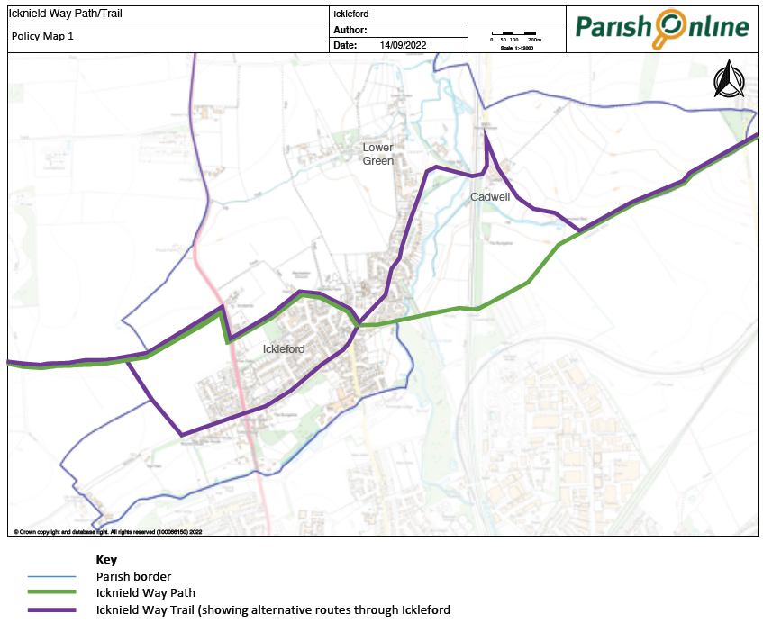
Annex 5: Icknield Way Path/Trail
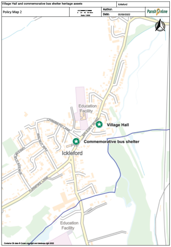
Annex 6: Additional Heritage Assets
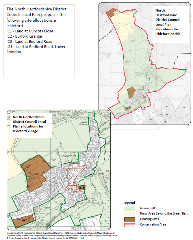
Annex 7: Proposed Development Sites in North Hertfordshire District Council Local Plan
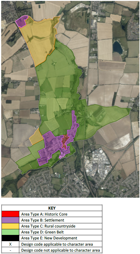
Annex 8: Design Codes and Area Types
Reproduced from Ickleford Design Codes. AECOM May 2022
|
Code |
Description |
A |
B |
C |
D |
E |
|
MO.01 |
Connectivity |
x |
x |
x |
x |
x |
|
MO.02 |
Public transport |
x |
x |
- |
- |
x |
|
MO.03 |
Wayfinding |
x |
x |
x |
- |
x |
|
MO.04 |
Junctions |
- |
- |
x |
- |
x |
|
MO.05 |
Inclusive streets |
- |
- |
x |
- |
x |
|
MO.06 |
Car parking |
- |
- |
x |
- |
x |
|
MO.07 |
Cycle & refuse storage |
- |
- |
x |
- |
x |
|
NA.01 |
Green Belt |
- |
- |
- |
x |
- |
|
NA.02 |
Green Networks |
x |
x |
x |
x |
x |
|
NA.03 |
Design with water |
x |
x |
x |
x |
x |
|
NA.04 |
SuDS |
x |
x |
x |
x |
x |
|
NA.05 |
Net gain |
- |
- |
x |
- |
x |
|
NA.06 |
Biodiversity |
x |
x |
x |
x |
x |
|
NA.07 |
Street planting |
x |
x |
x |
- |
x |
|
NA.08 |
New woodland |
- |
- |
x |
x |
x |
|
BF.01 |
Density |
x |
x |
x |
x |
x |
|
BF.02 |
Types & forms |
x |
x |
x |
x |
x |
|
BF.03 |
Heights |
x |
x |
x |
x |
x |
|
BF.04 |
Building line |
- |
- |
x |
- |
x |
|
ID.01 |
Local character |
x |
x |
x |
x |
x |
|
ID.02 |
Legibility |
x |
x |
x |
x |
x |
|
ID.03 |
Heritage Assets |
x |
x |
x |
x |
x |
|
ID.04 |
Plots & blocks |
- |
- |
x |
- |
x |
|
PS.01 |
Access street |
- |
- |
x |
- |
x |
|
PS.02 |
Residential street |
- |
- |
x |
- |
x |
|
PS.03 |
Tertiary street |
- |
- |
x |
- |
x |
|
PS.04 |
Secured by design |
x |
x |
x |
- |
x |
|
US.01 |
Schools |
- |
- |
- |
- |
x |
|
US.02 |
Shops |
- |
- |
- |
- |
x |
|
US.03 |
Community uses |
- |
- |
- |
- |
x |
|
HO.01 |
Space standards |
- |
- |
x |
- |
x |
|
HO.02 |
Accessibility |
- |
- |
x |
- |
x |
|
HO.03 |
Gardens |
x |
x |
x |
x |
x |
|
HO.04 |
Extensions |
x |
x |
x |
x |
x |
|
SU.01 |
Low carbon |
- |
- |
x |
- |
x |
|
SU.02 |
Insulation |
- |
- |
x |
- |
x |
|
SU.03 |
Solar panels |
x |
x |
x |
x |
x |
|
SU.04 |
Green roofs |
x |
x |
x |
x |
x |
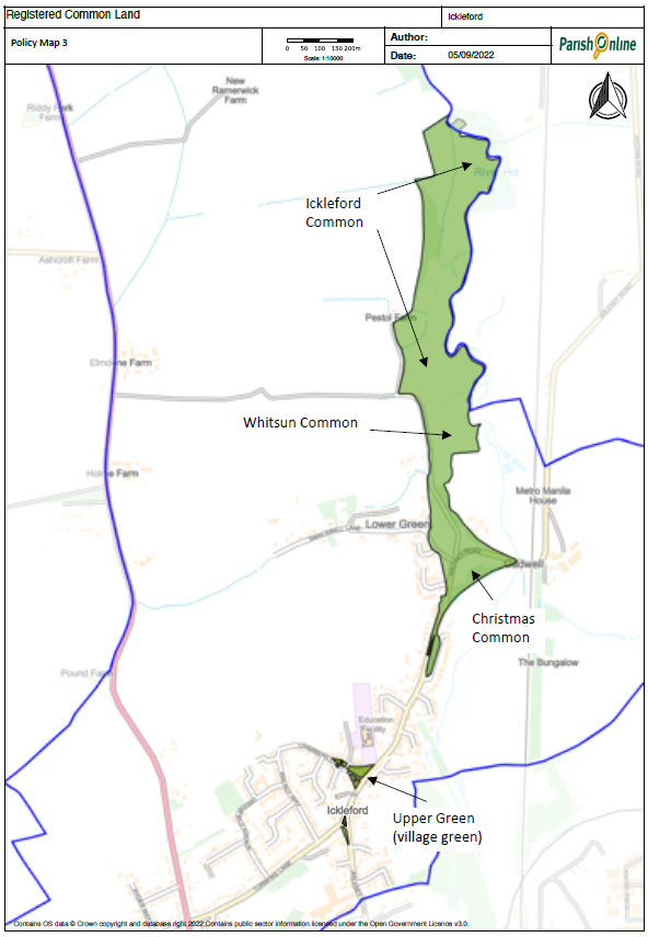
Annex 9: Common Land
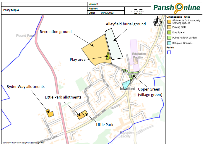
Annex 10: Open Spaces
Annex 11: Table of Aims and Policies
Table of Neighbourhood Plan Aims and Policies
Aims
Policies
Environment
- The countryside setting of the village will be protected and enhanced, by ensuring separation from the urban edge of Hitchin whilst retaining access to the countryside. Green spaces, views and local wildlife habitats, including rare chalk streams will be maintained and enhanced.
E1: Maintaining Separation, E2: Protecting the Landscape, SD5: Water Management E3: Rural Character, E4: Biodiversity
- Parish heritage assets and key public spaces will be protected and enhanced, ensuring that any future development enhances the existing character of the village.
E3: Rural Character, HE1: Protecting and enhancing Local Heritage Assets, C2: Recreation and Green Spaces
Sustainable Development
- High quality design will be secured in all new development reflecting the character of Ickleford and its rural setting and complying with Ickleford Design Code.
E3: Rural Character, SD3: High Quality Design
- Future housing will respond to local housing needs, be of a high standard of design and construction, and fit well into the context of the village in terms of type, mix, scale and character.
SD2: New Housing Development, SD3: High Quality Design
- New build housing should be constructed to high energy saving standards and be resource efficient in ways which are appropriate to the existing rural environment.
SD3: High Quality Design, SD4: Provision of energy Efficient buildings, SD5: Water management
Traffic and Transport
- The roads in Ickleford will be safe and accessible for pedestrians, cyclists and motorists. Improvements to the road network to increase safety and reduce the impact of congestion will be required alongside new development. Beneficial sustainable transport links (including pavements, footpaths, cycle routes and public transport) will be provided and appropriate parking solutions required.
MTT1: Provision for pedestrians, cyclists and horseriders, MTT2: Car Parking
Community
- Existing community facilities, such as the school, village hall, and sports and recreation centre, will be maintained and improved. Their wider use, and development to meet changing needs will be encouraged.
C1: Community facilities, C2: Recreation and Green Spaces, C3: Primary School
- The range of commercial activities and services in the village will be sustained and enhanced. Economic activity such as working from home and provision of small-scale business units will be encouraged.
C4: Supporting Local Employment and Agriculture
- The leisure and recreation opportunities for residents of all ages will be improved by encouraging community activities, and increasing the provision of open spaces and children's play facilities.
C2: Recreation and Green Spaces
Annex 12: Glossary
Adoption: The procedure by which a plan becomes formal council responsibility. The Neighbourhood Planning Regulations also call this stage 'made' for the purposes of a Neighbourhood Plan.
Affordable housing: Housing, provided to eligible households whose needs are not met by the market. Eligibility is determined with regard to local incomes and local house prices. Affordable housing should include provisions to remain at an affordable price for future eligible households or for the subsidy to be recycled for alternative affordable housing provision
Allocation: A piece of land that has had a particular use earmarked via a Neighbourhood Plan or Local Plan. This might be for housing, employment or another use such as open space.
Amenity: A positive element or elements that contribute to the overall character or enjoyment of an area. For example, open land, trees, historic buildings and the interrelationship between them, or less tangible factors such as tranquillity.
Biodiversity: The whole variety of life encompassing variations, including plants and animals.
Brownfield: Land that has been previously developed on (excluding agricultural or forestry buildings and residential gardens)
Conservation Area (CA): An area designated under Section 69 of the Town and Country Planning (Listed Building and Conservation Areas) Act 1990 as being of 'special architectural or historical interest' the character and appearance of which it is desirable to preserve and enhance.
Consultation Statement: A document which details when, where and how the public and stakeholders have been consulted, issues that were raised and how they were addressed.
Countryside: Land not within settlement boundaries
Community Infrastructure Levy (CIL): An amount of money payable to the Council on new housing and other development which is used for infrastructure and community facilities and services
Design Code: A document containing a set of design principles for a specific location or site.
Developer Contributions/Planning Obligations/Section 106: Developer contributions, also known as planning obligations, can be secured via a section 106 legal agreement or planning condition attached to a planning permission. They help mitigate any adverse impacts generated by new development on infrastructure and facilities.
Employment Land: Land that is used or is proposed to be used for offices, industry and/or storage and distribution – covered by the B Class in the Use Classes Order
Evidence Base: The information and data gathered by local authorities and other plan makers to inform and support the policy approaches to be set out in a Local Plan or Neighbourhood Plan
Examination: For neighbourhood planning, an independent assessment carried out by an examiner to determine whether your plan meets the Basic Conditions
Flood risk: The combination of probability of a particular flood event and its corresponding hazard and is used to refer to the scale of flood effect, combining hazard and probability, upon a particular site. Flood Zones 1-3b describes land with a specific probability of flooding with 1 being the least affected. Development may be restricted by Flood Zones.
General Permitted Development Order (GPDO): A statutory document that allows development (such as small house extensions) to be undertaken without planning permission.
Greenfield: Land where there has been no previous development.
Green Belt (GB): Designated areas around major built up areas which can only be developed under very special circumstances set out in the NPPF
Green Infrastructure (GI): A network of multi-functional green space and other environmental features, urban and rural, including both established and new sites - which support natural and ecological processes, and are capable of delivering a wide range of environmental and quality of life benefits for local communities.
Habitats Regulation Assessment (HRA): Tests the impacts of a plan or project on nature conservation sites of European importance and is required under EU legislation.
Heritage asset: A building, monument, site, place, area or landscape identified as having a degree of significance meriting consideration in planning decisions, because of its heritage interest. Heritage asset includes designated heritage assets and undesignated heritage assets identified by the local planning authority or Neighbourhood Plan (sometimes called local listing).
Infrastructure: Refers to the fundamental facilities and systems serving an area, including the services and facilities necessary for its residents and economy to function, including transport.
Local Nature Reserve (LNR): A site of importance for wildlife, geology, education or public enjoyment, declared by district, borough and county councils.
Local Plan: The main planning document in an area which sets out what type and how much development will occur across the area for the next 15 years or so. It also provides a suite of policies that help manage development including for design, access and amenity etc.
Local Wildlife Site (some areas County Wildlife Site) (LWS/CWS): Non statutory sites of substantive nature conservation interest determined locally according to national, regional and local biodiversity needs.
National Planning Policy Framework (NPPF): Sets out the Government's planning policies for England and how these are expected to be applied.
National Planning Practice Guidance (NPPG): A web-based resource, provides more detailed guidance on the contents of the NPPF
Neighbourhood Area: This is the area that the Neighbourhood Plan will focus on. For town or parish councils, the designated area is usually the boundary. Sometimes Parishes will combine to form one area.
Neighbourhood Development Plan or Neighbourhood plan (NDP/NP): Will set out the vision for a neighbourhood area and the planning policies for the use and development of land. These policies will be at a local level to support the strategic policies within the Local Plan. Plans should guide development rather than stop it. If adopted, a Neighbourhood Plan will become a statutory plan carrying equal weight with adopted local plan policies
Policy: A concise statement of the principles that a particular kind of development proposal should satisfy in order to obtain planning permission.
Parish Plan: A Parish Plan or community led plan can include planning related issues but they can focus purely on areas other than development. Parish Plans will not have the same legal status in planning terms as a Neighbourhood Plan
Policies Map(s): Illustrates the spatial extent of the planning policies and designated areas.
Qualifying Body: Either a parish/town council or neighbourhood forum, which can initiate the process of neighbourhood planning.
Referendum: A vote by the eligible population of an electoral area who may decide on a matter of public policy. Neighbourhood Plans are subject to a referendum of the eligible voters within a neighbourhood area. There is a specific question set in Regulations which has a yes or no answer.
Settlement Hierarchy: Many Local Plans set out a hierarchy of settlements according to their population and facilities. Different levels of growth may be attributed to each tier.
Site of Special Scientific Interest (SSSI): Designated under the Wildlife and Countryside Act 1981 by Natural England they are a protected area designated as being of special interest by virtue of its flora, fauna, geological or geomorphological features.
Strategic Environmental Assessment (SEA): European requirement assesses the significant environmental impacts of plans and programmes.
Strategic Flood Risk Assessment (SFRA): An assessment of the probability of flooding within a particular area.
Strategic Housing Land Availability Assessment (SHLAA): Assesses the suitability, availability and deliverability of land that have been promoted as sites for housing development
Strategic Housing Market Assessment (SHMA): Assessment of the local housing market, which studies the supply and demand of housing, the need for affordable housing and the affordability of the local housing market
Supplementary Planning Document (SPD): A document which elaborates upon a policy (ies) of the Local Plan to provide additional guidance for a particular topic or type of development.
Sustainability Appraisal (SA): An assessment of the environmental, social, and economic impacts of a Local Plan to check that the plan accords with the principles of sustainable development.
Sustainable Development: An approach to development that aims to allow economic growth without damaging the environment of natural resources thereby development which 'meets the needs of the present without compromising the ability of future generations to meet their own needs.'
Sustainable Drainage System (SuDS): An artificial drainage solution which reduces and slows the quantity and rate of surface water run off from new development, dealing with it as close to the source as possible
Tree Preservation Order (TPO): An order made by a local planning authority to protect a specific tree, a group of trees or woodland. TPOs prevent the felling, lopping, topping, uprooting or other deliberate damage of trees without the permission of the local planning authority.
Use Classes Order (UCO): The Town and Country Planning (Use Classes) Order 1987 (as amended) defines the categories of use of buildings or land for the purposes of planning legislation. In most cases, planning permission must be obtained to change the use of a building or land to another use class
Windfall Site: Sites which have not been identified as available in the Local Plan. They normally comprise previously-developed sites that have unexpectedly become available.