Ickleford Neighbourhood Plan 2022 - 2035 Submission Version March 2023
7. Environment
7.1. The village environment, particularly the open spaces and natural habitats, and its identity is well supported and highly regarded by village residents. In many cases, this was a significant factor for moving to, living in and remaining in Ickleford. The Questionnaire included 4 questions on the natural environment which generated a total of 924 responses, with many free text comments.
7.2. Residents consider that it is very important (82%) or fairly important (15%) that Ickleford maintains its own separate identity from that of Hitchin, Letchworth and neighbouring villages, with a similar quota supporting Ickleford's historic buildings and conservation area (Annex 1), and keeping development within this area to a minimum.
7.3. The identity of the village however is not just defined by its separation from other conurbations. The majority of respondents consider the natural environment and its wildlife, the rivers, common land and the agricultural landscape 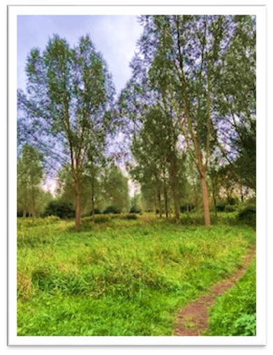 as not only important to conserve but are an intrinsic part of the Ickleford's identity and culture. When asked about the places that were important to them, 229 respondents took the trouble to collectively identify through 719 observations, all the areas of 'natural beauty' from the "Discover Ickleford – Walk the Parish" map as being of significance for walking and cycling, and enjoyment of the countryside views.
7.4. Many respondents thought that the 2020 Covid-19 restrictions and lockdowns had raised the importance of Ickleford's open spaces as essential to the mental and general health of village residents, both young and old; an appreciation that is almost certain to continue well after the current health crisis has passed since the habit has been established. Anecdotal evidence suggests that the village open space environment is also enjoyed by those walking and cycling in from the surrounding areas.
"We love and use all of the village and surrounding countryside paths and walks. Our whole family would love to see these green areas protected as they are so important to the character of the village not to mention for teaching our children about the environment and for our mental health. There is also an abundance of wildlife surrounding our village including barn owls, foxes, badgers, moles and deer and it is so important that we protect them."
Separation from Hitchin
7.5. Residents of Ickleford depend upon the proximity of Hitchin for employment, retail, services and education. However, the visual and functional separation of the two settlements is very important to residents. The Green Belt designation around Ickleford Village should ensure that this separation and distinct identity is retained. The Local Plan has changed the Green Belt boundary by allocating land for development and removing them from the Green Belt designation but it has also set the Green Belt and settlement boundaries for the coming years, through Policies SP2 (Settlement Hierarchy and Spatial Distribution) and SP5 (Countryside and Green Belt). Those boundaries will only be reviewed by the Local Plan in the future in accordance with the criteria set out in the NPPF.
7.6. The Local Plan is also able to allocate development sites in the Green Belt, removing the Green Belt designation. The proposed allocations for Ickleford (referred to later in this Neighbourhood Plan) have substantially enlarged the settlement boundary. It is noted that two of the allocations do not contribute towards the merging of the two settlements of Ickleford and Hitchin, but IC2 (Burford Grange) does and it is therefore very important that this separation is not further 'nibbled away' through piecemeal development.
7.7. It is noted that planning permission for five new houses behind Manor Close and off Turnpike Lane has recently been granted and the land status changed from Green Belt. A planning application for 53 houses (22/03040/FP) has recently been submitted to NHDC at land off Bedford Road Hitchin in the Green Belt. These developments have been met with concern by residents as they both appear to reduce the gap between the settlements, despite being designated Green Belt.
7.8. The NPPF states that inappropriate development is, by definition, harmful to the Green Belt and should not be approved except in 'very special circumstances'. It also sets out the exceptions where the construction of new buildings may be allowed, including for example, buidlings for agriculture, replacements or modest extensions to existing buildings, limited affordable housing for local community needs and redevelopment of previously developed land. Policy E1 seeks to bring to the attention of developers and NHDC that the area of Green Belt between Ickleford and Hitchin is particularly important for the separation of the two settlements, and if not designated as Green Belt (which is seen as the highest form of protection that planning legislation and policy gives), the Neighbourhood Plan would have designated this gap as a strategic gap.
Landscape
(1) Policy E1: Maintaining Separation
The undeveloped gap within the designated Green Belt between Ickleford and Hitchin shall be maintained. New development which would encroach visually and/or functionally on this gap should be refused unless it is in line with NPPF policy which allows very limited development under very special circumstances or development which is not deemed inappropriate. .
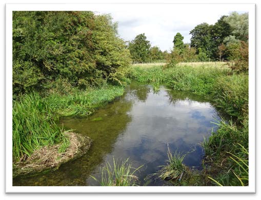
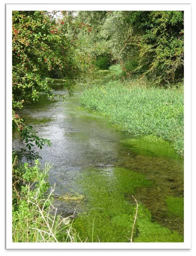
7.9. The Parish of Ickleford is relatively flat, particularly in the northern half, and is mostly farmland. The village itself lies at the southern end of the Parish. The boundary to the south is formed by the River Oughton, which rises to the west at Oughtonhead (Oughtonhead Common Nature Reserve is a Site of Special Scientific Interest (SSSI)). The River Oughton joins the River Hiz south of the village. The Hiz runs north from here forming a major element of the landscape and much of the eastern border of the Parish. These rivers are rare chalk streams, celebrated for their high biodiversity and habitats supporting vulnerable species. A series of commons and other publicly accessible land adjoins the river, both within the Parish going north, and to the south of the Parish, linking up with Burymead Springs Nature Reserve on the edge of Hitchin.
7.10. Railways form another important feature of the landscape. A stretch of the East Coast Mainline runs a little to the east of the river Hiz, forming a clear barrier between the land beyond it and the bulk of the Parish to the west. There are two crossing points: a foot and cycle bridge to the south, and a road going under the railway to the north. The decommissioned Hitchin to Bedford line still influences the landscape in the embankment that runs through the village.
7.11. The busy A600 is a further feature. This forms much of the Parish boundary to the East, with its traffic audible across much of the open landscape. Arlesey Road is another key route through the Parish, winding through the village, then passing under the railway bridge, past the lavender farm, to the fields beyond. These roads are closely entwined in the lives of residents, whether being used for transport or negotiated as pedestrians. The volume and speed of traffic is a concern to many, with future development both inside and outside the Parish likely to increase their use.
7.12. This landscape is also experienced by residents through recreation. A series of footpaths and bridleways make the countryside very accessible. Routes include the ancient Icknield Way which runs from west to east through the village across the river and up Wilbury hill towards Letchworth. To the northwest of the village another ancient path, known as Hambridge Way, leads to Pirton across open fields. A further route, the Hicca Way, follows the commons and meadows north alongside the river Hiz. Other footpaths and bridleways form a network of routes that provide numerous circular walks around the Parish (Annex 2).
7.13. The North Herts District Council Landscape Character Assessment (2011) reviewed the many landscape types across the district. It undertook to systematically divide the countryside into discrete and relatively homogenous units where physical, biological, historical and cultural elements occur in repeating patterns and share certain aesthetic characteristics. In this assessment the Parish fell within two defined character areas: Pirton Lowlands (Area 218) and River Oughton and Purwell Valleys (Area 217). Descriptions of these character areas and some of the recommendations for their management from the Assessment are given below.
7.14. Pirton Lowlands (Area 218)
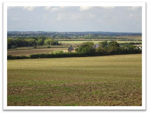 Large scale open, flat farming landscape given over predominantly to arable production. Long distance views of features such as water towers, churches and the chalk scarp. Remnant hedges, gappy and predominantly hawthorn but with occasional mature trees. Hedges generally well trimmed. Very little woodland cover except adjacent to settlements. Settlement pattern is nucleated with older settlements maintaining the use of local vernacular materials. Occasional farmsteads are less well integrated in terms of materials and general scale of farm buildings. Additionally the A600, Bedford Road, is quite prominent in the east.
- The landscape is of moderate sensitivity particularly to the introduction of urbanizing features and larger scale development. The landscape and built development guidelines for this include conservation of the traditional character of settlements ensuring that edge development uses vernacular materials and features to avoid inappropriate visual intrusion; protect and preserve the pattern of rural lanes and associated hedgerows; encourage broadleaved planting, hedgerow restoration and shelter belts; maintain the distinctiveness of river corridors from adjacent arable land; and conserve the open chalk landscape with its expansive views.
7.15. River Oughton and Purwell Valleys (Area 217) (This includes the River Hiz valley)
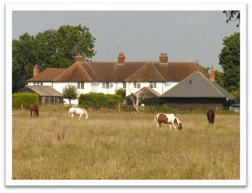
- Traditionally cattle grazed water meadows with poplar, willow and ash trees along the watercourses. Self seeded mature hawthorn also randomly distributed. Mature landscape character well defined by urban development (Hitchin). General change of land use adjacent to Ickleford where land is predominantly used for horse grazing and stabling. Paddocks are defined by post and barbed wire fencing.
- This Character Area is characterised by a series of river valleys and associated wetland communities. The wetland habitats associated with the Rivers Hiz and Oughton are highlighted as being of high biodiversity status and ecological importance by the Hertfordshire Biodiversity Action Plan. Ickleford Common is a rare example of an unimproved and traditionally managed grassland and is important for great crested newts. It is recognised as a key neutral grassland habitat by the Hertfordshire Biodiversity Action Plan.
- While the built development in Hitchin heavily influences the wider character area, the valleys are moderately sensitive to development, the reduction of the water meadows and removal of vegetation being the main threats. Development capacity is low partly because of the flood plain.
7.16. The ecologically important chalk streams and their management needs are discussed in the Biodiversity section below
7.17. New development should seek to respond to the landscape setting of the village and the proposed development site, by carefully siting and arranging buildings so that they do not introduce a jarring element into the Parish landscape. Planting schemes will be required and would be particularly encouraged where hedgerows can be planted or reinstated. Existing water features, including the rivers must be considered. The rare chalk stream ecosystem requires careful management, following advice and guidance from specialists (e.g. the Herts and Middlesex Wildlife Trust).
7.18. Some change that occurs in the landscape is outside planning control, but where planning permission is required for development, landscape features should be considered in a systematic way. Proposals for new development should include an appropriate landscape analysis either as a freestanding report or as part of a design and access statement.
Policy E2: Protecting the Landscape
Any proposals for development which will have an impact on the landscape should recognise and seek to protect and enhance the historic and natural landscape and local character of the Parish, including the delicate chalk rivers and their valleys, field ponds, mature trees and hedgerows. Such features should be protected and where appropriate, incorporated into any landscape design schemes and their long-term maintenance ensured.
Planting of hedgerows and trees, and enhancement of the existing vegetation will be supported and encouraged 'with careful management of the rare chalk stream ecosystem'.
Rural Character
7.19. Although close to Hitchin, the village of Ickleford remains rural in character with a clear separate identity. Several factors contribute to this distinct rural character. These include a
central village green, many other green spaces, numerous trees, space around buildings, rural lanes, a mixture of low-rise housing styles, and extensive well-used footpaths linking the settlement with the surrounding countryside.
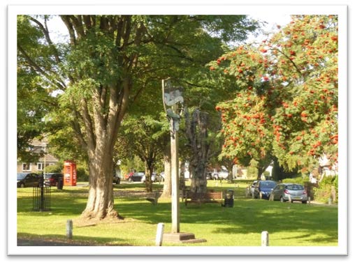
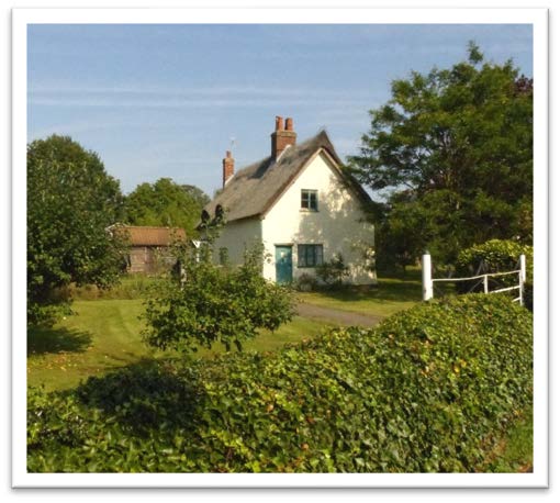
7.20. The village centres on Upper Green, an expansive and attractive green space at the heart of the village, surrounded by houses and amenities, such as 12th century Grade 1 listed St Katharine's church, the school, the village shop and country pubs. The Grade II listed school buildings are set back from the green behind more green space enclosed by a Grade II listed wall. There are numerous trees in this area, including many on the green. The large cedars in the adjacent churchyard are particularly striking. The high level of planting generally in residential properties throughout the village, and in the grounds of the church and school, contributes to the continuous green character of the village. With iconic views of the church and school, for many people Upper Green is strongly tied to Ickleford's identity and sense of community.
7.21. As elsewhere in the settlement, footpaths from the surrounding countryside come out into the centre of the village. The Icknield and Hicca Way are major walking routes that can be reached from just south of the green near the village shop. A footpath from the north of the green provides access to popular walking routes across the fields, the burial ground, play area and recreation ground. The edges of the village here, and elsewhere, open into green countryside. These spaces are important recreational areas and give the village its identity of a settlement set within fields. Many properties have views out over them. Easy access to the extensive commons, with the rare chalk stream of the River Hiz, connects residents to a beautiful and diverse natural environment.
7.22. At the north end of the village is Lower Green, another expansive green space with many mature trees and adjacent historic buildings. It is often traversed by walkers and horse riders from the nearby equestrian centre accessing the numerous footpaths and bridleways nearby. Throughout the village numerous green spaces around and between buildings also have an important role in giving the village a spacious and open feel, an intrinsic element of the character of Ickleford.
7.23. Snailswell Lane is a no through road country lane that skirts Lower Green before heading a short way west. It ends in an unpaved Byway Open to All Traffic (BOAT) with fields on one side and highly spaced-out bungalows and houses on the other in a mix of styles. Footpaths lead off from this route, including popular walks back towards the centre of the village. This highly rural part of the settlement is therefore familiar to many residents.
7.24. Arlesey Road and Turnpike Lane are the primary routes through the village. They converge at a triangle in the centre, where some of the oldest and most historic buildings can be found, many within the village's conservation area. Fronting the south end of Turnpike Lane, a row of 17th century buildings has a distinctive assortment of sizes. This includes a combination of elongated low single storey ranges, one and a half storey stable blocks, two storey gatehouses and an elevated clock tower. Steeply pitched roofs create an attractive group of varied roofscapes. These buildings are highly visible and situated close to the street frontage, presenting an impressive facade upon entering the village along Turnpike Lane. Arlesey Road itself is fronted by several historic buildings including Ivy Cottage, Rose Cottage and Orchard Cottage as well as the listed Ickleford school. These older buildings are interspersed with well-spaced modern housing, most of which are well set back from the roadside, effectively varying the road frontage throughout its length.
7.25. Chambers Lane and Greenfield Lane in the north-western corner of Ickleford, are narrow lanes with greener margins. Here, the buildings and tree coverage front directly onto the lanes, creating a sense of enclosure and, with proximity to the recreation ground with its green areas and mature trees, conveys a distinct rural setting to this area.
7.26. Leaving the core of the village east, west or south there are residential areas of varying ages. Even where the housing has a higher density, spaces around the buildings are retained, maintaining the rural feel.
7.27. The Ickleford Design Codes document divides the village into two main areas, the historic core and the settlement area. Guidance for new development in these areas is set out in the Design Codes. The intrinsic rural character of the village must be retained through reinforcing the eclectic nature of existing development whilst respecting the visual impact of new buildings and their mass, bulk and materials. It is considered fundamental that any development within the village is sympathetic with or enhances the character of the village. An example of where this ideal has perhaps not been achieved is the three storey flats situated in Icknield Close, built in the late 1970s. The height and lack of private gardens makes them feel very different to the rest of the village and rather incongruous. It is generally considered that future development should maintain a maximum two storey design unless in context with its surroundings, or its design in the case of the redevelopment of existing buildings.
Boundary Treatments and Frontages
7.28. The village style of frontage boundary treatment tends to be a mix of hedgerows, low brick walls or open frontages. White posts are a distinctive feature of the central village green, marking the edges of this space and of driveways. Whilst there is not a predominant style of the street frontages across the village, the open frontages tend to associate more with the more modern housing, however, this adds to the interesting character of the village. Where there are hedgerows and low walls, new development should seek to retain and recreate this style of boundary treatment, for example by avoiding the use of close boarded fences more suitable to the urban environment. A recently completed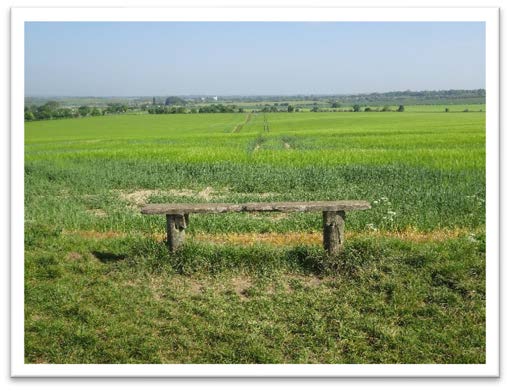 development installed iron railing boundary frontages which, being unique in the village, is not considered sympathetic to the village character, perhaps being more suited to a neo-Georgian/Victorian urban style development.
7.29. The village roads are lined with grass verges adding to its rural feel, as well as the biodiversity of wildlife. The planting of native hedgerows and trees also add to the rural character and should be retained.
Views
7.30. A key element of character comprises the views which connect publicly accessible points with the wider countryside, back towards the village and within the historic centre of the village allowing residents and visitors to enjoy all aspects of the Parish. Three types of view are identified in the Ickleford Design Code:
- Conservation area views: 4 views identified in the Conservation Area Character Statement 2019
- Rural to urban approach views: 3 views as seen from along the main road approaches to the village
- Natural Views: a further 9 views from public viewpoints which are important landscape views
7.31. All the views should be respected by new development, minimising the impact on them and maximising their enhancement.
Biodiversity
Policy E3: Rural Character
The rural character of the village and its surroundings should be respected through new development by ensuring that:
- proposals take advantage of the local topography, landscape and water features, trees and plants in the vicinity and on the site.
- the scale and character of new buildings are in keeping with the rural setting,
- the variable sense of space between and around existing buildings is retained where appropriate, particularly in the green heart of the village and where views of the countryside beyond the village are available. The design of new buildings should ensure that adequate space is provided around them to compliment the rural character of the village,
- boundary treatment and landscaping schemes are carefully designed so as to maintain the rural character of the area,
- Views of particular importance as defined on the Policies Map should be protected and not be obstructed by new development (Annex 3).
7.32. Protection of the natural environment, which is highly valued by local people, is critical, with reference to the important habitats and landscape identified in the Hertfordshire Biodiversity Action Plan 2006, the Landscape Character Assessment (2011) and the Design Codes. In particular, the chalk streams, valuable marshland and fen habitats along the riverbanks and Ickleford Common, which is a rare example of an unimproved and traditionally managed neutral grassland habitat, should be preserved.
7.33. There are only 200 chalk streams in the world with 85% found in South and East England. The streams are fed by springs in the chalk rock, with the clean mineral rich water supporting a variety of wildlife and habitats, including some of the UK's most vulnerable species in a fragile, highly specialised ecosystem. The specific plants (e.g. water-crowfoot) that grow in the riverbed create channels for the shallow clear water to flow. This in turn cleans the sandy riverbed and this provides important spawning grounds for brown trout and other fish that are particularly found in Chalk Streams.
7.34. Chalk streams are under extreme pressure from low water flows and pollution. The problems faced and potential solutions are outlined in the 'The Chalk Stream Restoration Strategy' (2021), whose authors include environmental organisations and Defra. The River Hiz Conservation Group is working with Herts and Middlesex Wildlife Trust to improve and maintain the River Hiz in Ickleford, which includes management practices specific to the needs of these chalk streams. The report on the River (River Hiz Restoration Plan 2019) outlines local practices to help improve the river. Particular challenges faced by this stretch of river include sewage overflows from Hitchin and polluted runoff from roads and local industry.
7.35. While the river is beautiful and much loved, public access into the river itself should be carefully managed and potentially avoided in places due to the fragile nature of the ecosystem.
7.36. Hertfordshire Environmental Records Centre have conducted an audit for Ickleford Parish and there are 2 veteran willow trees and a number of identified Local Wildlife Sites in the Parish (Ickleford Common North, Lower Green, River Hiz (Ickleford and Cadwell), Cadwell Grove Meadows, Cadwell Crossing, Icknield Way (Wilbury), Westmill Lane and Wilbury Hill), and two sites adjacent to the Parish (Oughton Head, and Cadwell Marsh & Burymead Springs) (See Annex 4). Many of these have important fauna such as water voles, water shrew, grass snakes and hares. River Otters have also been seen. Some of the recorded important plants include cowslips, meadowsweet, knapweed, scabious and buttercup species. These features should be protected and where possible enhanced as supported by NPPF policy 174 and Local Plan policies SP12 and NE4.
7.37. The south western part of Ickleford falls within a 2km radius of the Oughtonhead Lane Site of Special Scientific Interest (SSSI) and therefore planning applications within this impact Risk Zone would need to consider any potential impacts and risks posed to the SSSI.
7.38. All proposals for new development will be required to demonstrate how the design has taken into account its potential impact on local habitats and species. This will include the sites and features that are locally important in Ickleford, including the river valleys, trees, hedges and woodland and unimproved grassland. Development should be planned to avoid habitat loss and fragmentation, and opportunities should be sought to improve ecological connectivity, including through the creation, restoration and enhancement of linking habitats and 'stepping stones' through the landscape. Developers will be required to ensure that appropriate measures are put in place to protect wildlife and take every available opportunity to enhance biodiversity, wildlife corridors and important habitats. Where ecological surveys are required, submitted information must be consistent with British Standard 42020 2013.
"Ickleford Common and its beautiful views and its wildlife is a true gem."
7.39. Biodiversity Net Gain (BNG) is a concept proposed in the Governments 25 Year Environment Plan and mandated as a condition of planning permission in the 2021 Environment Act. Biodiversity Net Gain requires a minimum 10% increase in biodiversity after development, compared to the level of biodiversity prior to the development taking place. In locations such as Ickleford where all new development will be close to the countryside, it is really important that this principle is adopted to mitigate the impact of losing biodiversity value of undeveloped land to development. In order to objectively assess net ecological impacts and therefore achieve net gains in biodiversity, as required by the NPPF, it is vital that a fair robust mechanism for measuring these impacts is applied. To ensure they are consistently quantified, when required, applications must be accompanied by a Biodiversity Impact Assessment Calculation using the Natural England Biodiversity Metric. The application of this metric (which may be periodically updated) will be required for all development with negative impacts on biodiversity.
7.40. All new development should seek to increase biodiversity for example by habitat creation or enhancement, whether or not significant harm to species or habitats is anticipated. Examples of how enhancements could be achieved include:
- Planting native trees and species rich shrubs and hedgerows of local provenance
- Creation of orchards, wildflower grasslands and nature reserves
- Connecting existing habitats and enhancing migratory routes with additional planting (including green roofs and walls and hedgerows)
- Creation of ponds
- Provision of integrated roosting opportunities for bats and birds
- River or stream restoration following guidance and advice from specialists, (e.g. the Herts and Middlesex Wildlife Trust) who can share best management practices.
- Incorporating bat boxes etc into new buildings, particularly at the edges of the settlement.
7.41. Where Sustainable Urban Drainage systems (SUDS) are required to serve new developments, every opportunity to design them for wildlife gain and link them into existing habitats should be taken.
Policy E4: Biodiversity
New development will be required to protect and enhance existing natural features of sites, habitats and provide at least 10% net gain in biodiversity.
Provision of appropriate species-related measures will be required, including, for example, swift bricks, bat and owl boxes and the incorporation of appropriate native species into landscaping schemes.
Opportunities should also be taken by developers and landowners to link with existing wildlife corridors and sustainable drainage solutions in new development to complement nature conservation objectives.