Ickleford Neighbourhood Plan 2022 - 2035 Submission Version March 2023
3. Parish Description
3.1. Ickleford is a village and a civil parish in Hertfordshire, extending northwards towards Bedfordshire. It is located close to the outskirts of Hitchin along the bank of the River Hiz. It is a medium sized village with a range of facilities and the population of the Parish was 1,833 residents recorded at the 2011 census which was relatively unchanged from the 2001 census.
History and Heritage
3.2. Ickleford lies in the 'Hitchin Gap' just north of that town, placed in the valley of the River Hiz between the high land of Offley on one side and close to Wilbury Hill on the other. It grew up around a ford in the river where it is crossed by the Icknield Way Path/Trail, and so for several thousand years travellers passed along this route between Dorset and the Wash. Many Iron Age and other artefacts have been recovered from the site of a fort on Wilbury Hill, together with coins and pieces of pottery left there during the Roman occupation in Ickleford itself. Of the later Saxon occupation there is little evidence.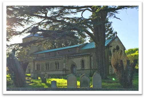
3.3. In the Domesday Book of 1086, Ickleford was not mentioned, probably because it was, with Ramerick, part of the manor of Pirton. However, at the beginning of the 12th century 'Iclesfort' was part of an agreement between a Reginald de Argentein and the Abbot of St Albans, appearing in a document that gives the village the earliest known version of its present name.
3.4. The church was built in around 1150, with the tower added in the 13th century. In 1859 a south aisle was added, designed by Sir Gilbert Scott one of the most distinguished architects of the time, completely changing the building's appearance.
3.5. The dissolution of the monasteries led to new owners of their extensive lands, with obligations to regulate and care for their communities. As head of its wealthiest family, Thomas Ansell became Lord of the Manor in 1587. The family grew richer over the decades, and was noted for its charitable work.
3.6. Although milling has recently ceased, Ickleford's four watermills were an important aspect of Ickleford life for many centuries
3.7. The Midland Railway line from Hitchin to Bedford and Leicester came and went, with lasting influence on the shape of the village. It opened in 1857 and closed in 1962, with the bridge over Arlesey Road removed in 1966.
3.8. An arts and crafts industry was brought to the village by Walter and Marie Witter who moved to the village in 1900. Marie taught embroidery to local girls, while Walter taught boys brass-, copper- and ironwork. This a developed into a business, The Ickleford Industries of Applied Art, which had customers from around the country.
3.9. Historically, most residents would have been employed in agriculture. However, new forms of transport helped make Ickleford an attractive base for people working elsewhere.
3.10. More information is available here: https://northhertsmuseum.org/wp-content/uploads/2020/07/The-origins-of-Ickleford.pdf
Landscape
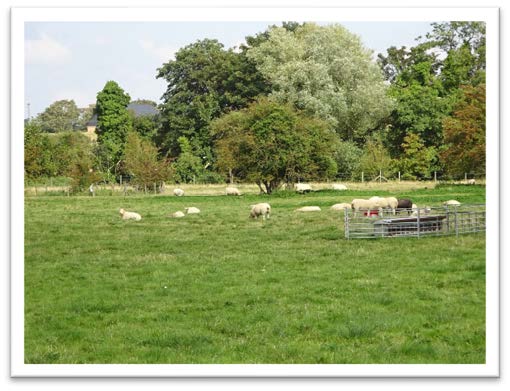
3.11. The majority of the Parish of Ickleford is relatively flat farmland. The village itself lies at the southern end of the Parish, with the River Oughton at its southern boundary. This joins the River Hiz, which then runs north along the village's eastern edge through meadows and commons. These rivers are rare chalk streams, celebrated for their high biodiversity. A stretch of the East Coast Mainline runs to the east of the River Hiz, and beyond this the land rises up Wilbury Hill towards Letchworth. The fields of Hitchin Lavender lie on these slopes, which are also traversed by some of the many popular footpaths and bridleways in the Parish. The busy A600 forms much of the Parish boundary to the East.
Education
3.12. The village has a primary school catering for around 200 children located on Arlesey Road. The present school was built in 1848 although the first record of a school in Ickleford was in 1839. The front of the school is a Grade 2 listed building and behind it are classrooms which were built in the 1960s and 1970s.
Recreation/Community Facilities
3.13. Ickleford Village Hall on Arlesey Road celebrated its 90th anniversary in 2015 and serves as a venue for local activities.
3.14. There is a large recreation ground which contains a playground and the Sports and Recreation Club with its sports facilities and licensed bar. The Club caters for several sports, including cricket, football, squash and pétanque, and is home to the Ickleford Cricket Club. There is also an equestrian centre with a Pony Club in the village.

3.15. Ickleford also has numerous clubs and groups including Scouts, Beavers, Cubs and Brownies, the Women's Institute, Karate, Pilates, Keep Fit, Line Dancing, Senior Fitness, Ballroom Dancing, Danse Herts and Ickledrama (a drama club for local children), Toddler Tales, Sing and Sign, and Phonics for Robots.
Local Business, Services and Employment
3.16. Ickleford has a number of typical local businesses, such as the shop, pubs and hairdresser. It also has some small business units housed in the old manor building and a large industrial flour mill, which may become a site for new housing. At the other end of the village lies an equestrian centre and the popular tourist attraction of Hitchin Lavender.
Population and Household Data
3.17. In the 2011 Census the Parish had a total of 1,833 residents, formed into 812 households and occupying 844 dwellings. The Office for National Statistics (ONS) produces mid-year population estimates for parishes and wards throughout the country. The mid-2019 population estimate for Ickleford is 1,835 – indicating population growth of around two individuals since 2011.
3.18. In the North Hertfordshire Annual Monitoring Data, it notes that since 2016 there has been a net increase of 34 dwellings in Ickleford; however, this may not have been reflected in the ONS information on population, as noted above, as the majority of these completions (32 units) were completed between 2018 and 2020. Therefore, it should be assumed that the population would have increased slightly since the mid-2019 population estimate.
3.19. A development of 144 houses in the north of the parish is nearing completion, with further large allocations proposed in the North Hertfordshire Local Plan. These could significantly increase the population of the parish.
Preparing the Neighbourhood Plan and the Design Codes Document
3.20. As part of the Neighbourhood Plan development process, the Parish Council asked for support from the government agency, Locality, and were awarded a technical assistance package to be provided by AECOM for Design and Masterplanning advice and guidance. This work has been of great value to the team. The Design Codes report contains a large amount of guidance, best practice, and future insight, including a chapter on design guidance, the first part of which (AECOM report Section 2) provides Design Codes for the Neighbourhood Plan and is published as a separate document. Part 3 of the Design Codes document provides masterplanning for the 3 sites allocated in the Local Plan. In order to illustrate the concepts described, AECOM created nominal site layouts and access indications. These do not define or describe the ultimate layouts or access proposals, which will be submitted by the developers concerned, and will be subject to all of the usual planning processes and consultations. Other parts of the AECOM report are individually quoted or referenced in this document
3.21. AECOM also produced an up-to-date Housing Needs Assessment.