Ickleford Neighbourhood Plan 2022 - 2035 Submission Version March 2023
(1) 11. Movement, Traffic and Transport
Map 4: Connectivity and Key Views.
11.1. Transport is historically an issue that is of concern and debate in Ickleford. Results of all Neighbourhood Plan consultations showed there was concern over the volume and speed of traffic passing through the village. Two specific potential accident 'black spots' were also identified; Cadwell Bridge and the roundabout at the junction of Turnpike Lane, Westmill Lane and Bedford Road. It is perhaps not surprising therefore that the free response questions in this section generated over 500 individual comments.
11.2. The car dominates transport in the village. Less than 3.0% of the respondents reported that their household had no car and 98.3% use a car at least once a week. Concerns about transport, almost exclusively issues relating to roads and traffic, produced more respondents (287) than issues relating to public transport (101) and the promotion of walking and cycling (99).
11.3. Cycle routes were requested to specific locations including Hitchin, along the A600, Stevenage and Letchworth.
Provision for Pedestrians, Cyclists and Horseriders
Rights of Way
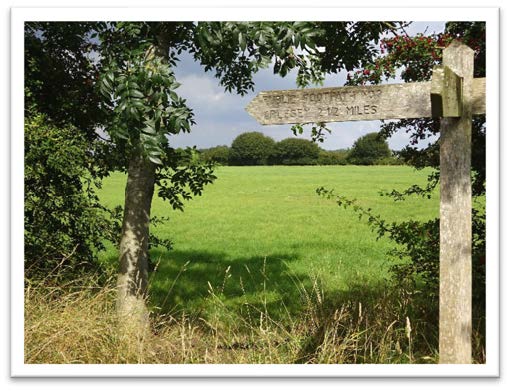 11.4. There are numerous footpaths and bridleways in the Parish. Public Footpaths and Bridleways are in the majority although there are several Byways Open to All Traffic. Public Rights of Way are highways that are purposed for active travel modes (Footpaths – on foot: Bridleways/Byways – on foot, horse and cycle). They provide for short journeys within the parish and also between the surrounding villages and towns. They also provide an excellent recreational facility. The Icknield Way Path/Trail are long-distance routes following rights of way through a historic landscape. The Path is available to walkers and the trail for use by those on horse-back or off-road cycle. Heading to the east of the village it provides a scenic route to Letchworth Garden City (see Annex 2. The Hicca Way is a walking route that follows the River Hiz Valley from Hitchin, through Ickleford, to Arlesey.
11.5. Bridleways in the Parish are well used by horseriders and cyclists
11.6. The Parish Council recognises the importance placed on the footpaths, open spaces and the associated other factors have on the character and historical value of Ickleford, and the reason that many residents chose, or choose, to live in the village and a large proportion of residents (74%) walk local Rights of Way every day.
11.7. Residents when responding to the questionnaire identified as being of importance to them: all footways and bridlepaths, and general green open spaces. (244 comments) and also value is placed on the footpaths and open spaces having a significant effect on the well-being and health of the village and its residents, particularly during 2020/21 for recreation, as well as physical and mental health benefits. (45 comments)
11.8. Improvements to the network will always be encouraged, in particular provision of footpaths, bridleways, restricted byways, permissive footpaths & established village walks such as the Barn Owl walks (Holwell, Ickleford, Pirton)
"I regularly walk all of the footpaths, bridleways, and byways, and did so before the coronavirus lockdown. For me, they are what make Ickleford special."
Paved Footways
11.9. The questionnaire also highlighted concerns regarding the lack of paved footways around the village. This is increasingly important in a village where there are several well supported local community facilities and villagers who regularly walk around the village for exercise
11.10. The challenges for paved footway provision in this village are as follows:
- The footway is not complete for several roads including Chambers Lane
- The central historic part of the village is characterized by narrow lanes with no footways
- Walking access to the village school
- Parking is restricted outside the facilities and where there is no footway, parked cars often block access for pedestrians.
- The absence of a walkthrough footway at Cadwell Bridge is dangerous
11.11. A partnership approach between the Parish Council, NHDC, Hertfordshire County Council and developers will be required to improve highway safety and minimise conflicts between road traffic, cyclists and pedestrians. It is intended to support new ways of managing the traffic throughout the parish by promoting pedestrian and cyclist safety and resident well-being through lower traffic speeds and traffic volumes.
11.11. Where new development is proposed, the footway network should be improved to assist in encouraging pedestrians.
(1) Policy MTT1: Provision for Pedestrians, Cyclists and Horseriders
Proposals for new development should not lead to the loss of Public Rights of Way. Where development is proposed it is expected that the network will be added to, upgraded (Footpath to Bridleway) and surface improved to enable short, everyday journeys on foot or cycle and enhance the opportunity for recreational use. The strategic principles of the Hertfordshire County Council Rights of Way Improvement Plan should be adopted where development is being considered.
Footpaths, bridleways and byways outlined in the Discover Ickleford footpaths map (Annex 2), including the Icknield Way Path/Trail, the Hicca Way and the Hambridge Way will be retained. New links both within the village, to neighbouring villages and to the wider countryside will be encouraged.
New development should include measures that that keep traffic speeds low and improve the provision of footways and access for pedestrians and cyclists and horseriders. Where they are proposed, new roads, junctions, footways and traffic management measures should be designed to complement the rural character of the village and reflect local heritage.
Public Transport
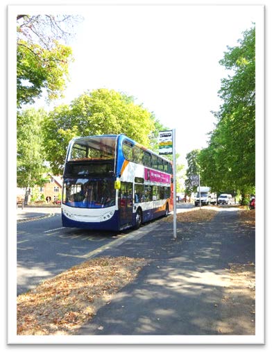
11.12. Public transport is not well used – 64% of the respondents to the questionnaire rarely or never take the bus. Reasons for not using the bus included that it was not frequent enough, too expensive and that other routes were required. Of the 54 responses suggesting new routes, the most popular were to Hitchin station (22), Letchworth (21) or to any station (not specified) (17) suggesting that the current public transport offering is not integrated enough. This is also shown by the comments on the lack of a bus service timed to allow students in the village to reach secondary schools in Hitchin.
Car Use and Parking
11.14. As set out above, many concerned residents through the questionnaire made comments regarding road safety in relation to traffic speeds and narrow roads and raised concerns about inconsiderate parking and current lack of parking provision.
11.15. Unfortunately, measures to slow traffic and motorists speed and behaviour cannot be within the scope of the Neighbourhood Plan because behaviour does not directly translate into land use, but the Parish Council will consider how these issues can be addressed separately.
11.16. The questionnaire highlighted challenges for parking within the village. This includes parking issues at local facilities in the centre of the village such as at the shop, during school drop off and pick up times and around the recreation ground. None of the available spaces should be reduced as it would exacerbate these difficulties.
11.17. With the demise of a suitable public transport system, the village relies heavily on private vehicles for access to workplaces, retail facilities, for secondary schooling, medical facilities and post office access. Whilst the village questionnaire highlighted that many villagers enjoyed walking around the village on a daily basis, or used the village shop frequently, frequent trips outside of the village are a necessity. Such trips require households to own vehicles, many with multiple vehicles requiring parking.
11.18. Adherence to NHD Council's parking standards will ensure that new dwellings have sufficient parking spaces. There is no need for specific requirements to be set out in the Neighbourhood Plan.
11.19. Electric vehicles are a broadly sustainable mode of travel that is increasing market penetration and national guidelines require that new developments of more than 10 houses shall provide electric charging points. However, in a village like Ickleford, where residents rely on cars to reach local services and shops, every new house should provide a charging point for electric cars.
"More and more traffic seems to be going through the village, made worse by massive housing developments to the north."
Policy MTT2: Car Parking
Proposals for new housing developments will provide parking in line with NHDC's parking standards and have adequate on-site parking to meet current and future needs, unless alternative and accessible car parking arrangements can be made which do not add to on-street congestion.
Electric charging points for cars should be incorporated in new housing development for each house.
New development should not result in the loss of publicly accessible off-street car parking. Developments which propose to remove off-road parking spaces will only be supported where alternative provision is made which increases or maintains the number of accessible parking spaces available on or within the immediate vicinity of the site.
Proposals for new development that provide additional off-road car parking spaces, to alleviate parking congestion will be encouraged.