Local Plan 2011-2031 Proposed Submission Draft
>SECTION THREE - DEVELOPMENT MANAGEMENT POLICIES
5 Economy & Town Centres
|
(4) Policy ETC1: Appropriate uses in Employment Areas |
|
Within the allocated Employment Areas, as shown on the Proposals Map, planning permission will be granted where:
Planning permission for other uses will only be granted as an exception to the above criteria where they are:
|
5.1 Within the four main towns there are a number of established Employment Areas, where the majority of employment-generating premises are located. They include B1 business, B2 general industrial and B8 storage and distribution uses. They are well-established areas and are a valuable resource to the District.
5.2 Over the lifetime of this Plan these will be supplemented by the new allocations identified by Policy SP3 which will become Employment Areas covered by this policy. Detailed considerations for these sites are set out in the Chapter 13 [communities] of this Plan which must be taken into account.
5.3 In order to maintain an adequate level of employment land to meet the needs of the local economy, we will protect defined Employment Areas from uses which would undermine their purpose or be better located in other areas of the District. The Council does not wish to inhibit the ability of existing firms to expand. It will be supportive of the redevelopment of sites which would lead to an improvement in the quality of employment floorspace suited to modern day needs.
5.4 Within the employment areas, certain areas will be reserved for B1 uses such as offices, research and development and light industry only. Due to the constrained nature of the District's Town Centres, and the competition from other land uses, much of the new office development anticipated over the plan period is likely to be within Employment Areas.
5.5 However, the Council recognises that Employment Areas are often sought after locations for a number of other uses. It is recognised that there is a need for some flexibility to meet the needs of uses such as: tyre and exhaust centres, trade wholesalers, vehicle hire, plant hire, motor trade uses and taxi vehicle depots. These are often partial B uses, combining a retail element with a predominantly business, industrial or storage use, or are sui generis[71]. These uses tend to cause conflict in other parts of the towns, such as town centres or residential areas as a result of impacts on residential amenity and living condition.
5.6 Motor vehicle premises, in particular, usually include a mixture of sales and repairs. The sale of motor vehicles tends to provide lower density of employment than normally expected in an employment area. The amount of the retail sales element on larger developments will be restricted in order to protect the availability of, and maximise the use of, employment land. In addition, in order to prevent the change of use of buildings to Class A1 (shops) a condition will be imposed on any grant of permission removing permitted development rights. These considerations apply to the sale of all types of vehicles.
5.7 Development proposals which seek to make use of the exception criteria of this policy will be considered on their merits. When assessing such proposals, the Council will have regard to (as applicable in each instance):
- employment generation on site;
- impact on relevant town centres;
- where appropriate, the level and type of retail involved on the site;
- any potential benefits to the community or surrounding businesses from the proposed use;
- the proportion of the site to be used for sales and display as opposed to repairs and servicing, in the case of motor trade uses;
- accessibility by non-car modes of transport;
- any evidence clearly demonstrating that:
- the land or premises is no longer required to meet future employment needs of the District;
- the land or premises is inappropriate or unfeasible for employment use, based on market conditions or amenity / living condition problems; and
- no other suitable sites outside designated employment areas are viable and available; and
- details of any sequential and / or impact testing.
5.8 A number of the District's Employment Areas are identified through the Hertfordshire Waste Local Plan as Employment Land Area of Search (ELAS) and parts of them may be acceptable for waste uses. The Hertfordshire County Council ELAS SPD[72] sets out specific considerations for each employment area.
|
(3) Policy ETC2: Employment development outside Employment Areas |
|
Planning Permission for employment uses outside of allocated Employment Areas will be granted where:
The Council will only permit the loss of existing employment uses on unallocated sites, where it can be demonstrated that:
|
5.9 There are a number of employment sites across North Hertfordshire that are outside the designated Employment Areas but which provide sources of local employment and services. These are in other parts of the main towns including town centres, in category A villages, and sometimes within category B and C villages or in the countryside following the re-use or redevelopment of agricultural buildings. Some have been there for a long time and may not be in the most appropriate location while others exist perfectly well adjacent to other uses such as residential and / or in their wider setting.
5.10 These sites are often small scale, although there are larger office developments in and around Hitchin and Letchworth Garden City town centres for example. The provision and retention of appropriate dispersed employment sites contributes to sustainable development aims by reducing the need to travel for local residents, something which is advocated in the NPPF. We will have regard to these factors to determine whether the proposed use is appropriately located.
5.11 The Council will permit appropriate proposals for farm and other land-based diversification schemes that benefit the rural area. The re-use or redevelopment of rural buildings for employment purposes will be subject to Policy CGB4.
|
(5) Policy ETC3: New retail, leisure and other main town centre development |
|
Planning permission for new retail, leisure and other main town centre development will be granted where:
|
5.12 Our evidence establishes the need for additional retail, commercial and leisure floorspace in the District over the period to 2031[73]. This Plan identifies six allocated sites where a substantial proportion of these needs will be met.
5.13 In assessing proposals for main town centre uses, we will adopt the 'sequential approach' as set out in Government guidance[74]. Therefore retail uses will be considered in the following order of preference:
- within the primary or secondary shopping frontages of town centres, on allocated sites within town centres, or in local centres;
- other parts of the town centres;
- the edge of centres; and
- out of centre, only where there are no available, suitable and viable sites which are sequentially preferable.
5.14 Business uses within town centres can add to the vitality and viability of centres. Office workers within a town centre will create more custom for shops and services. The Council is therefore generally supportive of new office development in town centres in accordance with the sequential test. Office development will be encouraged above ground floor retail.
5.15 The District has a number of local scale leisure facilities such as leisure centres and swimming pools. The provision of large scale leisure, entertainment and cultural facilities within the District is limited but this reflects the size of its catchment and the fact that residents also have good access to facilities in neighbouring towns such as Stevenage, Luton and Cambridge. North Hertfordshire's location within the catchment area of these larger centres will limit the potential for further commercial leisure and entertainment facilities.
5.16 Nevertheless, the first preference for the location of leisure facilities encompasses a wider area than retail as leisure uses should not be re-directed from the wider town centre areas to the primary shopping area. Therefore, the first preference for leisure facilities includes both the primary shopping area and wider town centre area.
5.17 For other town centre uses the test will start at number two in the list above.
5.18 With regard to retail use, the edge of centre is generally taken to mean up to 300m from the primary shopping frontage. For other main town centre uses, edge of centre means up to 300m from the town centre boundary[75].
5.19 This Plan identifies thresholds for the application of the impact test in North Hertfordshire's towns in line with our evidence[76]. Applications for main town centre uses on sites outside the town centres, not otherwise in accordance with the development plan and exceeding the thresholds below must also be assessed against the impact considerations set out in Government guidance before planning permission will be granted:
- Hitchin: 2,500m2 and above
- Letchworth Garden City: 1,000m2 and above;
- Baldock, Royston and elsewhere: 500m2 and above
|
Town Centre boundaries for Hitchin, Letchworth Garden City and Royston are shown on the Proposals Map. Within the designated Primary Shopping Frontages, planning permission will be granted at ground-floor level:
|
|
(1) Policy ETC5: Secondary Shopping Frontages |
|
In the Secondary Shopping Frontages of Hitchin, Letchworth Garden City, Baldock and Royston, as shown on the Proposals Map, planning permission will be granted at ground-floor level:
|
5.20 We want to ensure that the town centres maintain their primary retail function whilst increasing their diversity with a range of complementary uses, promoting competitive, flexible town centre environments. The concept of shopping as a leisure activity supports the encouragement of uses which increases the vitality throughout the day, extending the range of services for local people throughout the day and into the evening. The main function of the primary shopping area is retail, but town centres in general need a variety of other services such as banks, restaurants, pubs and personal services, which add interest and vitality and extend the use of the centres into the evening.
5.21 Too many non-A1 uses can create 'dead frontages' (units not normally open during normal shopping hours or which attract relatively few customers), reduce the interest and attraction of the primary shopping area, and harm the retail function. This is particularly a problem where there are a number of units in a row which are not shops. This is something the Council is keen to prevent.
5.22 We monitor all retail units within the four main town centres on an annual basis, as well as those in the local centres. There is evidence in some centres that shop (A1 use class) units are being lost to non-shop uses in the core shopping areas.
5.23 Within Primary Frontages we will retain the attractiveness of the essential and continuous shopping cores of our town centres; only retail (A1) will generally be permitted here.
5.24 For Secondary Frontages the policy is more flexible, allowing retail, office and restaurant (A1, A2, and A3 ) uses based on their contribution to vitality and viability and their ability to attract people to the centre. Other uses such as pubs (A4) and hot food takeaways (A5) can add to an areas attractiveness and vitality, however, control is needed to ensure that these uses do not detract from the centre and affect the shopping pattern.
5.25 Evidence in the form of predicted footfall, opening times and linked trips will be required for any application seeking to meet the exception criteria. Where a shop unit has been vacant for an extended period of time (normally at least six months), documentary evidence should demonstrate that all reasonable attempts to sell or let the premises for the preferred use(s) have failed.
|
Within Local Centres, as shown on the Proposals Map or identified in approved masterplans, planning permission will be granted where:
Proposals of over 500m2 gross will not generally be suitable in local centres. |
5.26 Local centres consist of village centres such as Codicote, Knebworth and Ashwell, and neighbourhood centres such as Walsworth (Hitchin), Jackmans (Letchworth Garden City) and Great Ashby. These centres vary in size from five units up to around twenty five units. Their composition also varies with some being almost all retail units, while others contain a mix of retail, food and drink and community facilities.
5.27 Local Centres are identified as forming part of our retail hierarchy in Policy SP4. The general locations of local centres are shown on the Proposals Map. Detailed maps for each centre showing where the provisions of Policy ETC6 are applied are contained in Appendix 3.
5.28 The village centres of Codicote and Knebworth are large enough to provide a focus for the communities local to them and a range of everyday shopping facilities and services. This includes: convenience stores, post offices, hairdressers, dry cleaners and food and drink establishments.
5.29 The Council considers that it is important that the neighbourhood centres continue to provide a mix of shopping, services and community facilities, and in particular retail units. A predominance of shops is considered to be necessary to secure future viability of these centres. However, some non-retail uses may be appropriate in the centres where this does not harm the mainly retail function.
5.30 In all local centres, the Council wants to retain local facilities and at the same time prevent changes to non-retail uses that would be more appropriate in larger centres or employment areas.
5.31 Where a vacant shop premises is subject to a proposed change of use, then documentary evidence will be necessary to show that all reasonable attempts to sell or let it for use as a shop for a year or more have failed. If there are other vacant units in the centre this will also be taken into account.
5.32 The Council may consider other non-retail uses, such as surgeries or other community and leisure uses appropriate, if it can be demonstrated that they would meet a local community need.
|
(3) Policy ETC7: Scattered local shops and services in towns and villages |
|
Planning permission for small-scale proposals providing new shops and services will be granted within existing settlements to serve the local community as an exception to the sequential approach set out in Policy ETC3(a). Planning permission for the loss or change of use of any shops, services or facilities outside the defined retail hierarchy will be granted where:
An exception to criterion (a) above will only be permitted if it can be demonstrated that the unit has remained vacant for a year or more, and documentary and viability evidence has been provided that all reasonable attempts to sell or let the premises for similar uses in that period have failed. |
5.33 Scattered local shops, services and other facilities in towns and rural areas provide residents with access to important goods and services. They also minimise the need to travel. The less mobile are particularly reliant on these facilities which include shops, post offices, pubs and petrol filling stations[77].
5.34 New facilities of an appropriate scale and location within Category A and Category B villages will generally be supported without the need for sequential testing of alternate locations.
5.35 However, given the high value of residential land in the rural area, there is often pressure from landowners to change the use of, or redevelop, existing facilities for residential purposes. This may be the case even where the business is thriving, if the return on an existing use is less than can be gained from residential development.
5.36 These facilities should be protected wherever possible and the policy seeks to prevent their loss. However, where it can be shown such facilities are no longer needed and not viable, then permission may be granted for a change of use.
5.37 Convenient walking distance, as set out in the policy, will be taken to be up to 800m for most existing users of the current facility, in line with Government guidance[78].
5.38 Some local facilities, such as pubs, can be listed as an Asset of Community Value (ACV). This provides additional protections if the owners wish to change the use of,, demolish and / or sell the facility. The fact that a facility is an ACV can be an additional material consideration in the determination of any planning applications. The Monitoring and Delivery section of this Plan provides additional information on ACVs.
|
(2) Policy ETC8: Tourism |
|
Planning permission for tourism-related development will be granted as an exception to the sequential approach set out in Policy ETC3(a) where it:
In the rural area outside settlement boundaries proposals will need to evidence why they cannot be accommodated within existing settlements and how they will support the rural economy. |
5.39 Tourism can bring benefits to an area both directly as a source of employment and income for the local tourism industry, and indirectly through tourism expenditure (e.g. retail, catering, and accommodation).
5.40 The three historic market towns of Hitchin, Baldock and Royston, along with Letchworth Garden City make North Hertfordshire attractive to visitors. Its rural area is also a place for people to visit, for tourism as well as leisure.
5.41 Although North Hertfordshire is not a major tourist destination, the inclusion of a tourism policy reflects this sector's growing significance as a form of economic development, and its potential to diversify both urban and rural economies. There are a wide range of attractions in the District, particularly those based on heritage and the countryside. Some, such as Letchworth, the world's first Garden City, Royston Cave and the British Schools in Hitchin are unique, whilst Knebworth House and grounds is a major day visitor destination and venue for music events in the region.
5.42 Tourism fulfils some of the aims of sustainable development because its survival depends upon conserving and maintaining the quality of the resources upon which it depends. Tourism provides an incentive and income to protect the built and natural environment, promoting these features for the enjoyment of local people and visitors, and enhancing local diversity and cultural traditions.
5.43 The Council supports proposals for new or extended tourist developments as a means to strengthen the local economy and increase visitors to the area in line with policies in the NPPF. To encourage sustainable forms of tourism, Policy ETC3 prioritises the location of possible developments within town centres in line with the sequential approach. Here, passenger transport can best be utilised and so limit associated traffic congestion.
5.44 Hotels and guest houses provide for both business and tourist visitors. Additional hotel bed-spaces should be encouraged in sustainable locations. The preferred locations for large hotels will be in town centres. Where there are no suitable sites, edge of town centre or other locations easily accessible by public transport may be considered.
5.45 However, in controlled circumstances, it may be appropriate to allow exceptions to a strictly sequential approach. Small hotels and guest houses may be appropriate in residential areas of towns and in villages.
5.46 Tourism growth trends indicate that the demand for bed and breakfast accommodation will increase. It is likely that the regular use of even one or two rooms of a house for bed and breakfast accommodation will be a material change of use requiring planning permission.
5.47 For rural proposals, the need is to protect the countryside for its own sake, with aspects such as nature conservation, archaeology, landscape and agricultural land in mind.
5.48 In the rural area the Council will be supportive of appropriately located facilities that support the rural economy and rural businesses and which respect the character of the countryside. The Council will weigh the degree to which proposals can be accessible by a variety of modes of transport with benefits to the rural economy and the potential of widening access to the countryside.
5.49 The Council will consider all tourism-related development proposals that fall to be considered under this policy in terms of:
- the sustainability of the location, scale and extent of the development;
- the expected level of activity;
- the number of visitors;
- the intensity of use; and
- the impact on the highway network.
(1) 6 Countryside and Green Belt
|
(11) Policy CGB1: Rural Areas beyond the Green Belt. |
|
In the Rural Areas beyond the Green Belt, as shown on the Proposals Map, planning permission will be granted where the development:
|
6.1 The Rural Area beyond the Green Belt covers the countryside to the east of the District that lies outside of the towns and Category A villages identified in Policy SP2. These areas do not meet the necessary criteria to be designated as Green Belt, but it is still necessary to impose restraints on development to prevent inappropriate schemes.
6.2 Where schemes meet one or more of the criteria above, they will be judged against other relevant policies of the Plan.
6.3 Policy SP5 explains that proposals within the Green Belt will be judged against the policies of the NPPF to determine whether they are acceptable in principle.
|
(9) Policy CGB2: Exception sites in rural areas |
|
Planning permission for community facilities and services or affordable housing
will be granted where:
The provision of limited market housing to cross-subsidise schemes under this policy will be granted planning permission in exceptional circumstances where it can be demonstrated that the level of market housing proposed is strictly necessary to make the required development deliverable and would accord with criteria (d) and (e) of this policy. |
6.4 The cost of housing in the District's villages is often higher than in the towns. As such, whilst there are problems of affordability across the District, they are most acute in the rural area.
6.5 This Plan proactively identifies a range of development allocations across the District. These will all be expected to contribute towards affordable housing provision resulting in a significant boost in new homes for local needs.
6.6 However, on occasion a small-scale need may still be identified for affordable housing or other types of community facilities to meet rural needs which cannot be met within the main towns and villages. This policy continues North Hertfordshire's historic approach of allowing specified development on exception sites.
6.7 This exception sites policy does not override other relevant policies, such as those relating to biodiversity and landscape. Where a need is identified, it will be necessary to identify an appropriate site for the development.
6.8 Any applications under this policy should be supported by specific evidence of need commissioned, or otherwise endorsed by, the relevant Parish Council.
6.9 A number of the settlements identified in Policy SP2 are located relatively closely to one another. In justifying the exception site, applicants should have regard to actual and potential sites:
- Within the parish where development is proposed;
- In immediately adjoining parishes and towns; and
- otherwise within a reasonable travelling distance (by various modes) of the location where the need has been identified.
6.10 Even where affordable housing is delivered under exception policies, residents may still require a significant income. In some instances, this has led to providers requesting a relaxation of the local occupancy restrictions that are normally placed upon exception sites. This means that the eventual occupants of new homes are not necessarily those for whom the scheme was originally envisaged. In compiling evidence of need, applicants should give consideration to these issues (see Policy HS2 and supporting text).
6.11 In exceptional cases, it may be necessary to allow some enabling development. Where market housing is proposed, it must be justified by the submission of viability evidence which will be independently tested at the cost of the applicant.
6.12 In all cases, there will remain a general presumption against development which would have a significant adverse impact on the general aims of countryside and Green Belt policies.
6.13 Over the lifetime of this Plan, parish councils (or other relevant bodies) may be able to make use of new powers that will enable them to deliver the types of scheme envisaged by this policy directly, and without the need for planning permission[79]. However, in many instances, it may remain preferable to meet such needs through a planning application.
|
(3) Policy CGB3: Rural workers' dwellings |
|
Planning permission for new homes to support existing agricultural, forestry and other rural businesses will be granted where:
Planning permission for the removal of agricultural occupancy conditions will only be granted where:
|
6.14 The significant majority of land in North Hertfordshire remains rural and in productive agricultural use. Agriculture and other rural businesses underpin both the rural economy and the landscape character of the rural areas.
6.15 In some limited cases there may be a need for workers to live in close proximity to a specific rural location or use[80]. A functional need test will be applied to establish whether it is necessary for one or more workers to be available at all times in order to sustain the business. This will need to be demonstrated over a period of time.
6.16 We will consider the history of the business and land holding to establish the recent pattern of use of the land and buildings. This will include consideration, for example, of whether any existing homes, or buildings suitable for conversion, have recently been sold separately from the land holding concerned. Such a sale could constitute evidence of a lack of need.
6.17 If a new home is deemed essential to support a rural business, it should first be permitted through a time-limited permission, or temporary accommodation such as a caravan. Permission for permanent dwellings will normally only follow in the event of a persistent need. Any temporary or permanent home will be restricted to the occupancy of a worker associated with the business.
6.18 Agricultural occupancy conditions are normally imposed to recognise that permission would not otherwise have been granted. Removing these conditions can undermine policies which otherwise seek to restrict the building of new homes in the countryside.
6.19 Any such applications will be closely scrutinised. In particular, where criterion (ii) is met, the Council may subsequently resist future applications for further agricultural or rural business premises on the same site.
|
(2) Policy CGB4: Existing rural buildings |
|
Planning permission for the re-use, replacement or extension of buildings in the Green Belt or Rural Area beyond the Green Belt will be granted where:
|
6.20 North Hertfordshire has a large number of rural buildings. The traditional houses in the rural area tend to be small cottages which would have been occupied by agricultural labourers. Many of the other rural buildings are barns and agricultural buildings. Such buildings define the character of parts of the District.
6.21 However, there are pressures for change to rural buildings which need to be managed. Smaller houses might be attractive in their own right, but often come under pressure for large extensions or complete rebuilding to a larger scale. Likewise, non-residential rural buildings sometimes become obsolete for their original purpose and come under pressure for re-use or replacement.
6.22 In these cases, we will ensure that proposals do not cause harm to the rural area. Such harm may come from a variety of sources. The extension, alteration or replacement of buildings can change their character negatively, for example where a modest cottage, over time, becomes a mansion.
6.23 National guidance seeks to support economic growth in rural areas and also avoid the provision of new, isolated homes in the countryside[81]. Policy CGB4 should be read alongside that advice and viewed in light of the Council's consequential preference that rural buildings be re-used for economic development purposes where possible and consistent with the other policies of this Plan.
6.24 In some instances, buildings affected by this policy may additionally be listed or subject to other heritage designations and other relevant policies and guidance will need to be taken into account. All proposals will be considered against the general design policies of this Plan.
|
(7) Policy CGB5: Urban Open Land |
|
In areas of Urban Open Land, as shown on the Proposals Map, planning permission will be granted where the development:
|
6.25 Green Belt and the Rural Area Beyond the Green Belt provide strong policy protections for the countryside of North Hertfordshire. However, it is important that these designations are, wherever possible, defined using clearly recognisable features.
6.26 To the south-east of Baldock, north-east of Royston and south of Little Wymondley, dual carriageway bypasses provide clear, defensible boundaries which can be used to help establish the limits of Green Belt and Rural Area designations.
6.27 Leaving all unallocated areas within these boundaries as undesignated 'white land' would mean some land parcels on the urban fringe would not benefit from any specific policy protections. They could be subject to speculative applications which would be detrimental to local character, or would not provide an appropriate transition from the urban to the rural.
6.28 However it is also recognised that, in appropriate circumstances, this land could provide opportunities for the location of general landscaping, school playing fields, sports pitches or other low-intensity uses associated with nearby development and / or the adjoining settlements. Where such uses are sought within Urban Open Land, all reasonable attempts should be made to maintain openness and careful consideration should be given to the scale of any ancillary and treatments such as boundary fencing or bunding.
6.29 Intensive agricultural uses and larger rural buildings, such as new barns and storage facilities, will not be considered appropriate on Urban Open Land. However, it may be possible to accommodate some less-intensive rural land uses and facilities, such as paddocks or small holdings without prejudicing the overall aims of this policy.
6.30 In considering the intensity of any proposed uses of Urban Open Land, consideration will be given to the nature and scale of any associated secondary effects, such as vehicular movements, as well as the development itself..
(1)
7 Transport
|
(11) Policy T1: Assessment of transport matters |
|
Planning permission will be granted where:
|
7.1 Every year, developers add around 20km of new highway to the Hertfordshire's road network. It is important to ensure quality and consistency in these works.
7.2 In assessing development proposals, we will generally be guided by the advice and responses of Hertfordshire County Council as the local highway authority who assess the impacts of development proposals on behalf of the Council as a Statutory Consultee to the planning process. The County Council support the use of Transport Statements, Assessments and supporting documents in order to do this. These reports also guide requirements within the development site.
7.3 Guidance published by the County Council sets out the thresholds at which these are required[82]. The current thresholds are set out below, though it should be noted that:
- site-specific circumstances may result in statements or assessments being requested for development below these thresholds; while
- guidance may be updated over the lifetime of this Plan.
7.4 The most up-to-date requirements, including highway design standards, should be referred to as proposals are developed. We will also have regard to relevant national guidance in our decision-making[83].
Table 1: Thresholds for Transport Statements and Transport Assessments
|
Transport Statement |
Transport Assessment |
|
|
Residential (C3) |
>50 homes |
>80 homes |
|
Business (Use Class B1) |
>1,500m2 Gross Floor Area (GFA) |
>2,500m2 GFA |
|
Industrial (B2) |
>2,500m2 GFA |
>4,000m2 GFA |
|
Warehousing (B8) |
>3,000m2 GFA |
>5,000m2 GFA |
|
Non-food retail |
>800m2 GFA |
>1,500m2 GFA |
7.5 Travel Plans should be provided for all developments which exceed the Transport Assessment Threshold. Travel Plans should set out measures that will be adopted by developers that encourage the use of sustainable modes for journeys and reduce single occupancy vehicular travel. We and / or the County Council may require other supporting documents to assess the development, particularly to ensure appropriate arrangements are in place to facilitate delivery, servicing and / or waste collection.
7.6 Transport models have been developed to support, and assess the proposals contained in, this Plan. Using these, we have identified a number of mitigation measures that would be needed to support the plan's implementation[84]. Developers should make use of these models and their results when preparing their proposals to ensure assessments are carried out consistently. Developers need to detail the design of schemes and test appropriate mitigation measures.
7.7 However, it is also recognised that the modelling carried out to support the Local Plan is more strategic in its nature and developers will be required to supplement these findings with additional local intelligence and modelling to ensure the impacts of their schemes on individual settlements, localities and / or junctions are fully understood and, where necessary, mitigated. Contributions will be sought towards the implementation of relevant schemes in the vicinity of the development site under the requirements of Policy SP7.
7.8 It is important to ensure that new developments offer appropriate and practicable sustainable transport alternatives. All major developments should set out how public transport, walking and cycling will be addressed. In doing so, it is recognised that it may not always be appropriate to incorporate clearly defined provision for all modes, and solutions will vary from urban to more rural areas[85].
7.9 Notwithstanding this, development proposals should provide safe pedestrian access in all instances. On larger developments, demarcated cycle routes should additionally be provided along principal arterial roads. These should connect to lower order streets where safe on-street cycling can be encouraged or where shared spaces might be an appropriate response.
|
(5) Policy T2: Parking |
|
Planning permission will be granted where:
|
7.10 Most development proposals generate demand for parking relating to different users be it for visitors, residents, employees or solely for operational purposes.
7.11 Parking is one tool that can be used to influence travel demand and mode of travel. Previous policies to influence car ownership based on maximum standards of parking provision at trip origin (residential parking) are acknowledged to be flawed. Experience in North Hertfordshire shows that insufficient parking provision in residential environments can have an adverse impact. Limiting parking availability at trip origins does not necessarily reduce car ownership and can displace vehicles onto the adjacent local highway network, diminishing the streetscape, causing increased levels of congestion, and potentially obstructing emergency vehicles.
7.12 It is now recognised and accepted that, in most locations, demand management through parking is most appropriate at the trip destination (for example commercial, leisure and retail parking). The need for greater parking control has developed in line with the growth of motorised traffic, particularly in the rise in ownership and use of private cars. The emphasis of sustainable transport is now placed on locating residential development where car use is less likely / and or necessary for many trips.
7.13 The main priority of this policy is, therefore, to seek to influence car use, through application and assessment of parking standards, promoting use of alternative modes of transport and travel planning, as opposed to restricting car ownership. Many residents may have cars, which influence car ownership levels, but choose to travel sustainably for school or commuting purposes.
7.14 Car parking can also impact on the design quality and flood risk of development and as such, consideration should be given to this in accordance with Policy D1: Design and Sustainability.
7.15 Residential parking standards are set out in Appendix 4 of this Plan. Parking provision in accordance with these standards will generally meet the day to day needs of the occupiers but without over provision. Relevant applications will be required to meet these standards. Recommended standards for other uses, and other types of parking, including cycle parking, are set out in supplementary guidance[86]. This document also provides general guidance on issues such as design and layout.
7.16 Applications should have regard to this advice and other relevant plans and strategies including those produced by Hertfordshire County Council as the local highway authority, and show how they have been taken into account in developing proposals. Advice will be regularly reviewed over the plan period to take account of changes in car ownership and travel patterns and mode share, national policy guidance and any other relevant matters.
8 Housing strategy
|
(36) Policy HS1: Local Housing Allocations |
|
Local Housing Allocations are listed by parish and settlement in Chapter 13 [Communities] and shown on the Proposals Map. Planning permission for residential development and associated infrastructure on these sites will be granted where:
Planning permission for other uses will be refused. |
8.1 This Plan establishes targets to provide 15,950 homes in North Hertfordshire over the period 2011-2031. Approximately 75% of this number is accounted for by the general allowances and Strategic Housing Sites set out in Chapter 3 (see Policies SP8 and SP14 to SP19)
8.2 The remainder will be delivered through Local Housing Allocations within and adjoining the District's towns and villages. These are individually set out in the Communities chapter of this Plan.
8.3 An indicative number of homes is shown for each site based on our evidence[87]. We will take a design-led approach to each site as schemes are brought forward. This may result in housing numbers changing in response to the pre-application and planning application process and our policy approach allows for development to fall within a reasonable range of our initial expectations.
8.4 Chapter 13 [Communities] also sets out detailed considerations for each site that must be taken into account. This includes specific requirements, such as the provision of space for school expansions, or mitigations. Beyond these, all developments will have to comply with any other relevant policies in this Plan.
8.5 Where local communities prepare neighbourhood plans, these allocations may be subject to additional requirements or change. Prospective applicants should be mindful of emerging and adopted neighbourhood plans in the parish or settlement where the site is located.
|
(28) Policy HS2: Affordable housing |
|
|
Planning permission for new homes will be granted where:
Where development of a site is phased or divided into separate parts, or could reasonably be considered part of a larger development which would exceed the thresholds, it will be considered as a whole for the purposes of affordable housing provision. |
|
|
Size of site (gross dwellings) |
Target percentage of dwellings to be affordable |
|
11 – 14 dwellings |
25% |
|
15 – 24 dwellings |
35% |
|
25 or more dwellings |
40% |
8.6 North Hertfordshire is going to be affected by considerable housing growth over the plan period. However, if all the new houses were to be sold privately, the District's own housing needs would fail to be met. New-forming households on lower incomes would not be able to afford to live locally.
8.7 These problems are well recognised across the country as a whole and the Government encourages local planning authorities to set out policies on affordable housing[88], based on assessments of local housing needs.
8.8 Affordable housing is provided for those who cannot access open market housing. It includes social rented and affordable rented housing and intermediate housing, such as shared ownership schemes. It is secured with planning conditions and legal agreements to make sure that the benefit of the housing continues in the long term.
8.9 At least one-third of new-forming households in the District over the plan period may require assistance with their housing[89]. Over the plan period, this target should be achievable. On most sites, targets to provide up to 40% affordable housing can be supported[90]. Policy SP7 sets out our approach where developers consider that the policy requirements of our plan will adversely affect viability. We will robustly examine any schemes which seek to make affordable housing provision at below target levels.
8.10 In circumstances where below target levels of affordable housing are agreed but the Council considers that viability may improve over the lifetime of the proposed scheme, review mechanisms will be built into any relevant agreements. This is more likely to occur in developments with long build-out times, where there is presently a limited comparable market with which to compare viability factors or where approvals are granted at a time of adverse economic conditions.
8.11 Our general expectation is that any affordable housing provision required and secured under this policy will be made on site. Although sites of between 10 and 14 units will deliver relatively low numbers of affordable homes, Registered Providers operating in the District are normally willing to take on these small groups of new homes. The onus will be firmly upon the applicant to demonstrate that any exceptional circumstances exist to justify off-site provision contributions in lieu or, on Strategic Housing Sites, a phased approach to affordable housing delivery.
8.12 Our normal approach will be to request 65% rented tenures and 35% other tenures for affordable housing to meet the needs of local people. This will be used as a starting point for negotiation, but this may change as the plan period progresses or to reflect site-specific circumstances.
8.13 The strength of local house prices means that affordable housing products which are linked to open-market sales or rental values will remain out of reach for many households and this issue will need to be taken into consideration.
8.14 We will also need to respond to any changes at the national level such as funding regimes or proposals for new housing products, such as Starter Homes.
8.15 In all instances, the most appropriate mix of affordable housing will be negotiated having regard to relevant information including the results of the latest local (parish) or district-wide Housing Needs Surveys, the most recent Strategic Housing Market Assessment, the location of the site and nature of the proposed scheme as a whole.
8.16 The Council has previously issued supplementary guidance which provides further information on the provision of affordable homes in the District[91]. This will be updated and / or replaced over the lifetime of this Plan. Development proposals should have regard to this information and any other relevant housing strategies.
8.17 The situation regarding the provision of affordable housing on the edge of rural settlements as an exception to normal policies of rural restraint is considered in Policy CGB2.
|
(10) Policy HS3: Housing mix |
|
Planning permission for new homes will be granted where:
|
8.18 National policy requires local plans to provide for a mix of housing that meets the requirements of different groups within the community[92]. Having regards to our evidence, we will seek to deliver a broad balance between smaller (defined as 2-bed or less) and larger (3-bed or more) homes over the plan period.
8.19 The majority of completions since 2011 have been for smaller units whilst some of the sites identified through this Plan are specifically anticipated to focus upon small homes and / or flats. These are identified in the relevant site-specific considerations in Chapter 13.
8.20 On most suburban and edge-of-settlement sites, applicants should therefore make an initial assumption of 60% larger (3+ bed) and 40% smaller (1 or 2 bed) homes to ensure an overall mix is achieved. The most appropriate solution will be considered on a site-by-site basis having regard to this, the criteria set out above and the outcomes from applying Policy HS2.
8.21 Given the design-led approach to development set out through this Plan, district-wide density standards have not been prescribed. Development on the periphery of settlements should generally be at a lower density to mark the transition to the rural area beyond. In town centres and close to the railway stations higher densities will be considered appropriate in principle but will require particular care in the design with respect to avoiding the sense of overcrowding or congestion. Further advice is set out in the Design policies of this Plan.
|
(6) Policy HS4: Supported, sheltered and older persons housing |
|
Planning permission for sheltered and supported housing in uses classes C2 and C3 will be granted where:
Planning permission for residential developments of 100 units or more will be granted where:
|
8.22 Over the plan period, there will be a substantial increase in the number of and proportion of older residents in North Hertfordshire. The number of people aged 70 or over is predicted to increase by more than 10,000. By 2031, they will account for 1 in every 6 of the population, compared to 1 in 8 now[93].
8.23 This reflects national trends. The 'baby boom' generation born in the period after World War II are now reaching, and surpassing, retirement age.
8.24 Older people are living longer, healthier lives and that the forms of specialist housing offered today might not offer the best solutions in future years. Government policy seeks to support people living at home for as long as possible[94]. As a result, the types of home that will be needed by our older residents will vary. Many will continue to live in their own homes with a minimum of support. Others may seek to downsize. However, some people will require more specialist accommodation or assistance.
8.25 Other groups will also have support needs, including people of all ages with physical or learning disabilities.
8.26 A number of models exist to meet the housing needs that this creates.
- Homes with extra care, sheltered housing and assisted living normally consist of self-contained accommodation in a purpose-built block or small group of homes. Care is provided for those who would like the comfort of knowing assistance is available, or cannot live completely on their own, but do not need significant levels of personal care; while
- Care or nursing homes provide a degree of personal care and / or long-term assistance for those who cannot live independently.
8.27 Accommodation that is self-contained with only modest levels of care will normally fall within use class C3. For the purposes of planning, this will contribute towards the overall targets for new homes identified in Policy SP8. Accommodation with greater levels of care, support and / or communal facilities will tend to fall within use class C2. However, the distinction between these uses can be fine.
8.28 Some future sheltered and supported housing needs will be delivered by the market in response to perceived demand. Further accommodation will be delivered by registered providers. Individual proposals will be assessed having regard to the criteria above.
8.29 On the largest housing sites we will additionally expect a modest proportion of sheltered and / or supported housing to be provided to contribute towards the modelled demand for older persons housing[95]. This should include affordable housing provision where appropriate.
8.30 All of our Strategic Housing Sites will be large enough to support the provision of local facilities such as shops and bus routes. It should be possible for each of the sites identified in Policy SP14 to SP19 to accommodate the requirements of this policy.
8.31 On other sites, we will take a common sense approach. Where an application is close to essential facilities, and can accommodate supported, sheltered or other older persons provision in a coherent way, we will expect it to be provided. In some instances, such as sites on the edge of villages with fewer facilities, it may not be as practical to insist on these types of homes.
|
(10) Policy HS5: Accessible and adaptable housing |
|
Planning permission for major residential development will be granted where
|
8.32 The Government's revised approach to technical standards for new development identifies three categories of accessibility:
M4(1) – visitable dwellings
M4 (2) – accessible and adaptable dwellings; and
M4 (3) – wheelchair user dwellings[97].
8.33 Our evidence demonstrates that it is both appropriate and viable to pursue the higher M4(2) and M4(3) standards in North Hertfordshire[98]. Requiring 50% of new homes on major residential schemes to meet the intermediate standard will make a positive contribution to future needs as the population ages. This requirement should be applied across both market and affordable homes.
8.34 The highest M4(3) standard should only be applied to homes where the District Council will be responsible for allocating or nominating a person to live in that dwelling[99]. A modest proportion of affordable homes will be required to adhere to this additional standard.
8.35 Compliance with M4(2) and M4(3) standards will be monitored through the Building Regulations regime as new homes are built. Planning permissions will be appropriately conditioned to say that this requirement must be met.
8.36 However, it is also necessary to ensure that schemes can be built out in accordance with a granted planning permission. Appropriate information should be submitted alongside planning applications. Applicants should demonstrate through their drawings and / or Design & Access statements that the standards can be accommodated when the scheme is built.
|
Planning permission for relatives' and dependents' accommodation formed by the adaptation or extension of the main dwelling will be permitted where:
Free standing annexes will exceptionally be allowed where the above criteria are met and it can be demonstrated that adaptation or extension of the main house is not possible. |
8.38 Where such accommodation can be provided as a self-contained planning unit such as through subdivision of the existing home or the provision of an additional dwelling, it will be treated as a windfall and normal policies will apply.
8.39 Where interdependent accommodation is proposed, or where subdivision or the creation of an additional dwelling would not otherwise be acceptable, this policy will be applied.
8.40 Case law surrounding the provision of annexes is complex. Anyone considering building an annex for relatives or dependents should seek professional advice and engage with the Council at an early stage in the process.
|
(7) Policy HS7: Gypsies, Travellers and Travelling Showpeople |
|
Land at Pulmore Water, as shown on the Proposals Map, is allocated for the provision of 7 permanent Gypsy and Traveller pitches to meet the District's needs up to 2031. Planning permission for accommodation for Gypsies and Travellers or Travelling Showpeople will be granted where:
Where all the above criteria are met, proposals for sites for Gypsies, Travellers and Travelling Showpeople may be appropriate in the countryside as rural exception sites (in line with Policy CGB2) but Green Belt policies would still apply. |
8.41 The Local Plan should make appropriate provision to meet the needs of Gypsies, Travellers and Travelling Showpeople in North Hertfordshire. There is recognition that the three groups are different and have very different needs, but for the purposes of this policy the key considerations are very similar.
8.42 There is currently one private Traveller site at Pulmore Water in the parish of Codicote. This consists of twelve permanent and six temporary pitches. There is no public site in the District. Historically, the District has not been an area where significant numbers of Gypsies, Travellers or Travelling Showpeople have resided in or resorted to, which is supported by figures for unauthorised encampments and developments.
8.43 As with affordable housing, current government guidance allows Gypsy and Traveller sites to be located in the open countryside, as an exception to normal policies of control. This is in recognition of the particular difficulties that Gypsies and Travellers have obtaining and affording land within settlements.
8.44 Our evidence identifies a requirement for 7 additional pitches over the period to 2031[100]. The area covered by the temporary planning permission on the Pulmore Water site meets this requirement though the existing permission expires in 2017.
8.45 This area is therefore allocated for permanent provision and to provide certainty going forward. Based on current evidence, it should prevent the need for future 'single issue' reviews of this policy and the long-term needs of these communities will be considered as part of the next general review of the plan alongside the needs of the settled community.
9 Design
|
(13) Policy D1: Sustainable design |
|
Planning permission will be granted where development proposals:
|
9.1 National guidance states that planning should achieve high quality and inclusive design for all development. Development proposals should consider the potential for minimising their impact on the environment both during construction and throughout the life of the development whilst creating development that responds to and enhances its surroundings. It's also recognised that good quality design is essential for health and well-being.
9.2 Development must respond positively to the site and the local context taking into consideration position, orientation, scale, height, layout, massing, detailing and use of materials.
9.3 A Landscape and Visual Impact Assessment (LVIA) should be undertaken to assess the significance and effect of development proposals on the landscape and peoples views and visual amenity. Design and Access Statements (DAS) are required for most planning applications. A DAS require applicants to explain and justify the key elements of the proposal and show that the physical, economic, policy and social context of the site and its locality have been taken into account.
9.4 Public realm, publicly accessible space, creates the character and sense of place for our environment. Enhancing existing public realm or creating new using high quality materials, design and workmanship will result in a high quality environment that makes a positive contribution to a sense of place and healthy communities. Developers are expected to have regard to emerging advice and good practice to ensure that development schemes positively contribute to the public realm, local street scene and wider landscape through high quality design.
9.5 Sustainable Drainage Systems (SuDS) if incorporated into the layout of the development at the early stages can have a positive impact not only on the local drainage system but also on the landscape amenity and biodiversity of the site. Trees, shrubs and other soft landscaping provide a number of environmental benefits, ranging from climate change mitigation to the management of surface water drainage and flood risk. Further information is provided in Natural Environment Policy NE8: Reducing Flood Risk and NE9: Sustainable Drainage Systems
9.6 Using innovative design to reduce energy consumption and waste from the construction and use of buildings can optimise the potential of the site and have a positive influence on the environment. Development should meet the requirements of the most up to date standards on carbon emissions and embedded renewable sources. The reduction of carbon emissions should be achieved by both making new development as energy efficient as possible and through increasing the amount of energy gained from renewable sources. The efficient use of new materials from local or sustainable sources, together with the reuse and recycling of materials will help to reduce the energy used and the waste created in the development. It will also help the development to achieve local character and distinctiveness. The policy encourages sustainable design, and the use of materials and technologies that will ensure that the energy used in the construction and throughout the life of the development will be minimised.
9.7 Existing vegetation should influence the layout and design of development. A vegetation condition survey should be undertaken to ascertain what plants within and adjoining the site, which would be effected by development, are worthy of retention and what protection measures should be put in place during construction. The British Standard BS5837: Trees in relation to design, demolition and construction – recommendations sets out guidance on tree retention, effect of trees on design considerations and means of protecting trees during construction.
9.8 Development proposals should consider how the scheme will integrate with the existing circulation patterns particularly pedestrian, cycle and public transport. Safe and secure pedestrian and cycle routes should be provided both within the site and linking into the wider network. The policy seeks to ensure that the design and location of new development makes it accessible to all potential users. There is a need to ensure that where appropriate, new development includes facilities or open space that is conveniently located and easy to gain access to by all potential users.
9.9 The potential for future changes in technology and lifestyles should be considered when planning and designing schemes to ensure flexibility in the use of buildings throughout their life.
9.10 Creating safe and attractive places by designing-out opportunities for crime and anti-social behaviour through the incorporation of physical and management measures will help to minimise the risk of crime. Development should be built to the Police preferred minimum security standard of Secured By Design SBD Part 2. The location of parking areas should ensure that they create safe and secure places to leave and access vehicles.
9.11 Street furniture such as signs, lighting columns, bins and seats can create clutter and have a negative impact on the visual quality of an area. Similarly, parking areas need to be well designed and integrated into the development scheme. Good design can ensure that cars and street furniture are not dominant features in new developments.
9.12 Development proposals should be in line with current regulations and guidelines and any future changes in Legislation or to the Building Regulations that will affect the sustainability of a building.
9.13 Building Futures[101] is an interactive tool for new development in Hertfordshire. Building Futures is mentioned in the Design SPD[102] and developers are strongly encouraged to look at this suite of documents, which provide practical and technical guidance on reducing the environmental impact of development, and will be helpful in enabling developments to satisfy this policy. Information on the Hertfordshire Design Review Panel and the way it can advise on development proposals is also available.
9.14 Sport England's Active Design guidance on how the design and layout of residential and other areas plays a vital role in keeping communities healthy and active should be considered.
9.15 Further guidance is set out in the Design SPD which covers key principles for all development within the District and specific principles for each of the four towns, the villages and the rural area. The Design SPD identifies other relevant guidance prepared for North Hertfordshire such as Conservation Area Statements, Town Centre Strategies, Urban Design Assessments, Landscape Character Assessments, the Green Space Strategy and the Green Infrastructure Plan. These documents are available to view on the Council's website and are updated on an on-going basis.
9.16 For development proposals in Letchworth Garden City reference should be made to the Design Principles available on the Heritage Foundation's website.
|
(1) Policy D2: House extensions, replacement dwellings and outbuildings |
|
Planning permission for house extensions will be granted where:
Planning permission for replacement dwellings and outbuildings will be granted where:
|
9.17 There is a need to maintain a high quality environment in residential areas and across the district as a whole whilst allowing flexibility with regard to house extensions, replacement dwellings and outbuildings. The policy requires that consideration is given to the effect that a proposal may have on the living conditions of neighbouring occupiers and the character and appearance of the locality in which they are proposed as these are matters that can often be overlooked with the desire for increased living space.
9.18 This policy also serves to protect the character and appearance of those remaining modest rural workers dwellings and to ensure that proposals for replacement or extension of dwellings in the countryside would not have a materially greater impact. Further guidance for proposals in rural areas is set out in the Countryside and Green Belt policies.
|
Planning permission will be granted for development proposals which do not cause unacceptable harm to living conditions Where the living conditions of proposed developments would be affected by an existing use or the living conditions of an existing development would be affected by a proposed use, the Council will consider whether there are mitigation measures that can be taken to mitigate the harm to an acceptable level. If the Council is not satisfied that mitigation proposals would address the identified harm, development proposals will not be permitted. |
9.19All development has the potential to have an adverse impact on its neighbours, in a wide variety of ways. . Such harm may arise from traffic generation, parking, loss of daylight and sunlight, noise, overlooking, pollution (including light pollution) and dominance as well as other issues..
9.20 A significant number of proposed sites for housing in the District are on previously developed land within urban areas. Such sites are often close to existing residential areas. Care is needed to ensure that the adverse impacts of any such development on neighbouring residents is minimised. It is not practical to provide absolute protection for existing residents' current living conditions, instead, there is a need to ensure that any impacts a development has are identified and appropriate mitigation built into the scheme.
9.21 In the rural area, farm diversification schemes can help support the District's rural economy. However, some diversification schemes could seriously affect the living conditions of the surrounding area, especially if they generate significant traffic.
9.22 There are two ways mitigation may occur. Either the development can incorporate measures to reduce the effect it has, or it can fund works off site to reduce the impact on those affected by it. This latter course of action may be appropriate for development such as the expansion of airfields, where there will inevitably be an increase in noise, but it may be possible to provide sound protection to those buildings affected by that noise.
9.23 This policy also covers the situation where there is an existing use which will have an adverse impact on a proposed residential development site. The proposed development will need to show that satisfactory living conditions will be achieved taking into account the nature of the existing development – for example, homes proposed in a noisy area.
|
(6) Policy D4: Air quality |
|
Planning permission will be granted where development proposals: a. give consideration to the potential or actual impact on local air quality, both during the demolition/ construction phase and as a result of its final occupation and use; b. propose appropriate levels of mitigation to minimise emissions to the atmosphere and their potential effects upon health and the local environment; and c. carry out air pollution impact assessments, where required, to determine the impact on local air quality of the development, otherwise the development may be refused. Where air pollution impact assessments are not required there will still be a requirement on developers to provide appropriate levels of mitigation to address emissions of pollutants to the atmosphere. |
9.24 This policy supports Policy D3: Protecting living conditions but also encourages sustainable development, in particular sustainable transport (Policy SP6: Sustainable Transport). The District will be accommodating a significant amount of development during the plan period which will undoubtedly generate additional road traffic and put added pressure on existing road networks. Therefore, because the major source of local air pollution in the District originates from road traffic emissions it is important for this Plan to deal with the implications for air quality of the anticipated development.
9.25 The outcome of the air pollution impact assessment will be used to determine the nature and scale of the steps that should be taken to remove or reduce the scale of those concerns. Ideally this will occur at the design, planning and/or development stage, but may in certain circumstances rely on post development mitigation measures. It is conceivable that in certain circumstances the outcome of an air quality impact assessment may demonstrate that a development is unsustainable from a local air quality perspective and may be refused.
9.26 Two of the main roads that cross the District do so on a north – south axis: the A1(M) and A10. Another main road is the A505 that traverses the District on a southwest – northeast axis. It is the A505 that is currently directly associated with air quality concerns because it passes through the four main population centres of the District namely Hitchin, Letchworth Garden City, Baldock and Royston. Of particular concern is the area in the south of Hitchin. Notably Stevenage Road (A602) near the Hitchin Hill roundabout, which has been designated an Air Quality Management Area (AQMA) and the Payne's Park roundabout at the A602 junction with the A505 which is to be designated an AQMA in 2016.
9.27 The NPPF[103] states that air pollution is a material planning consideration and more specifically that planning policies should sustain compliance with and contribute towards national objectives for air pollutants and the presence of AQMAs and their Action Plans. Furthermore, it states that the effects (including cumulative effects) of pollution on health should be taken into account. Therefore, because each local authority will have its own unique causes and contributing factors to elevated levels of air pollution it is vital that local development documents include policies to appropriately influence the District's specific development demands.
9.28 The policy addresses the protection of the health of the residents of proposed developments, as well as the protection of the residents of existing properties particularly, although not exclusively, those that live in close proximity to the District's roads. In addition to the air quality problems identified in Hitchin that are associated with elevated nitrogen dioxide (NO2), levels of NO2 are close to exceeding a national air quality objective around the A505 in the Hitchin Street / Whitehorse Street area of Baldock. Furthermore, particulate matter air pollution is a public health concern, which is reflected by the presence of a national air quality objective and a public health outcome indicator.
9.29 The policy will allow the Council to achieve a consistent and transparent approach to the development of land where air quality concerns are relevant. It will also help to influence the nature of such developments so as to minimise or remove the potential for adverse impacts on air quality. Or where appropriate, identify and justify the need for and nature of measures to help to mitigate any otherwise unavoidable adverse air quality impacts from permitted developments.
9.30 The following are types of developments for which the Council would expect consideration to be given to the submission of an air quality impact assessment:
Within, or adjacent to an AQMA, applications for:
- housing;
- biomass or other forms of combustion boiler;
- industrial developments;
- car parks; and
- any other development likely to significantly increase vehicle movements
Anywhere else in the District, applications that are considered to be 'major' in scale for example:
- significantly increase car parking facilities;
- significantly increase vehicle movements, particularly heavy duty vehicles;
- introduce biomass or other combustion boilers and industrial processes of a particular scale;
Or that:
- introduce humans to an area where air pollution is an issue, but where humans were previously not present
9.31 For other types of developments an air quality impact assessment will not be required but there will be an expectation for the developer to negotiate and agree air quality mitigation measures that are proportionate to the scale of the proposed development.
9.32 A more detailed description of the type of air pollution mitigation required for developments and those developments considered to be 'major' can be found in the NHDC Air Quality Planning Guidance Document[104].
9.33 Methods available to mitigate the impact of developments on air quality may fall into a number of categories and will be considered against other relevant policies in the Plan:
- appropriate parking standards
- accommodating infrastructure to support the use of low emission vehicles
- appropriate location and design of buildings
- incentives to support initiatives for public transport, car sharing and using alternative modes of travel
- contributions to improve road and traffic management, infrastructure to support alternative modes of travel and air quality monitoring
9.34 This is not an exhaustive list and more detail will be found in the NHDC supplementary Air Quality Planning Guidance Document.
(1) 10 Healthy Communities
|
(5) Policy HC1: Community facilities |
|
Planning permission for new community facilities will be granted where they are:
The loss of community facilities will only be permitted where this is justified by:
|
10.1 The National Planning Policy Framework recognises that the planning system plays a role in facilitating social interaction and creating healthy, inclusive communities. Community and recreation facilities, together with green spaces play an important role in enabling people not only to participate in physical activities but also in cultural pastimes, all of which can help to enhance physical, spiritual and mental well being.
10.2 Community facilities include: town and village halls, community centres, sports halls, theatres, museums, libraries, places of worship, doctors and dental surgeries and schools. Development proposals which affect local shops and pubs will be considered under Policy ETC7: Scattered local shops and services in towns and villages.
10.3 The Local Plan can help towards meeting the objective of making communities healthier through the retention and provision of cultural, leisure and community facilities.
10.4 It is anticipated that many of the new community facilities that will be required over the lifetime of this Plan will be provided in association with the strategic developments allocated in this Plan. However, there may still be occasions where the provision of new, of extension of existing, facilities in other locations is required.
10.5 It is important that these facilities are situated within local communities so that they are accessible, help to reduce the need to travel and provide opportunities for people to participate in activities within their own community.
10.6 The Council's Community Halls Strategy and Indoor Sports Facility Strategy and Action Plan set out detailed guidelines for the provision of new community facilities which developers should take into account in the design of any new development[105].
10.7 At the same time, existing facilities, whether publicly or privately owned, can be subject to development pressures for alternative uses. It is important that, where appropriate, such facilities are retained within the local community.
10.8 Some local facilities can be listed as an Asset of Community Value (ACV). This provides additional protections if the owners wish to change the use of, demolish and / or sell the facility. The fact that a facility is an ACV can be an additional material consideration in the determination of any planning applications. The Monitoring and Delivery section provides additional information on ACVs.
(1) 11 Natural Environment
|
(2) Policy NE1: Landscape |
|
Planning permission will be granted for development proposals that:
|
11.1 National policy[106] requires the protection and enhancement of valued landscapes. The emphasis of the policy is to ensure that the design of a development proposal is sensitive to the local context to ensure that the scheme makes a positive contribution to the landscape.
11.2 The policy aims to protect and enhance the quality of the natural environment by requiring development proposals to take into account the landscape character and environmental features and built form of its surrounding area.
11.3 The North Herts Landscape Study[107] is an assessment of the character of the landscape within the District. There are 37 separate landscape character areas covering the District, some lie totally within the District while some extend into adjoining districts. The study provides a description of the distinctive characteristics of each landscape character area based on factors such as the geology, landform, soil types and historical activities for each area.
11.4 The North Herts Landscape Study also identifies the inherent sensitivities of each character area in landscape and visual terms together with its capacity to accommodate a range of different types of development. Development should respect the sensitivities of each landscape character area and accord with the guidelines for managing change identified for each landscape character area in relation to built development and landscape management.
|
(3) Policy NE2: Green infrastructure |
|
Planning permission will be granted where development:
|
11.5 Protection of those sites which contribute to the diversity of green infrastructure throughout the District from inappropriate development is important. However, in some cases it needs to be acknowledged that appropriate mitigation measures would enable development to take place
11.6 This policy will also ensure that where new green infrastructure is created appropriate management and maintenance regimes are in place to provide the framework for its long-term use.
11.7 North Hertfordshire has significant green infrastructure assets. These are identified in the North Hertfordshire District Green Infrastructure Plan[108] and include ancient woodlands (e.g. at Newton Wood), biodiversity rich landscapes (e.g. Therfield Heath), chalk streams, rivers, and valleys (e.g. Lilley Bottom and the Mimram valley). They also include the historic designed landscapes of Letchworth Garden City and the literary associations of Forster Country, north of Stevenage. The plan also identifies areas of green infrastructure deficiency as well as opportunities to create new green infrastructure. Developers should use the guiding principles set out in the Green Infrastructure Plan to influence all development proposals from an early stage in the design process.
|
(4) Policy NE3: The Chilterns Area of Outstanding Natural Beauty (AONB) |
|
Planning permission for any proposal within the AONB, or affecting the setting of the AONB, will only be granted when it:
|
11.8 Part of the District between Hitchin, Lilley and Hexton (which follows the escarpment of the Chiltern Hills) has been recognised as being of national importance and forms part of the Chilterns Area of Outstanding Natural Beauty (AONB).
11.9 Areas of Outstanding Natural Beauty (AONBs) are designated by the Government for the purpose of ensuring that the special qualities of the finest landscapes in England and Wales are conserved and enhanced. In policy terms they have the same planning status as National Parks.[109] The Chilterns AONB was designated in 1965 and extended in 1990. The Countryside and Rights of Way Act 2000 places a statutory duty on local authorities to have regard to the purpose of conserving and enhancing the natural beauty of AONBs when coming to decisions or carrying out their activities relating to, or affecting, land within these areas.[110]
11.10 The Chilterns AONB covers 13 local authorities and the Councils work together to safeguard the future of this shared nationally protected area through the Chilterns Conservation Board. The Board prepares a statutory AONB Management Plan which has been endorsed by the Council as a material consideration in planning decisions.[111]
11.11 Proposals for development within the AONB will be considered against national guidance. Where the proposed use can be considered acceptable in principle, we will use the detailed policies of this Plan to determine whether permission should be granted.
11.12 The AONB is a nationally designated landscape and as such permission for major developments will be refused unless exceptional circumstances prevail as defined by national planning policy.[112] National guidance explains that whether a proposal constitutes major development is a matter for the relevant decision taker, taking into account the proposal in question and the local context.[113]
11.13 In determining compliance with criterion b, actions to conserve and enhance the AONB shall be informed by landscape assessment, having considered any relevant landscape character assessments and landscape and visual impact assessments and shall focus upon:
- the Chilterns AONB's special qualities which include the steep chalk escarpment with areas of flower-rich downland, broadleaved woodlands (especially beech), commons, tranquil valleys, the network of ancient routes, villages with their brick and flint houses, chalk streams and a rich historic environment of hillforts and chalk figures;
- the scope for enhancing and restoring those parts of the landscape which are previously developed, degraded or subject to existing intrusive developments, utilities or infrastructure;
- locally distinctive patterns and species composition of natural features such as chalk downland, trees, hedgerows, woodland, field boundaries, rivers and chalk streams;
- the locally distinctive character of settlements and their landscape settings, including the transition between man-made and natural landscapes at the edge of settlements;
- visually sensitive skylines, geological and topographical features;
- landscapes of cultural, historic and heritage value;
- important views and visual amenity;
- Tranquillity, dark skies and remoteness and the need to avoid intrusion from light pollution, noise, and motion; and
- in the case of major development proposals, shall be informed by landscape and visual impact assessment, having considered all relevant landscape character assessments.
11.14 Development proposals which lie outside the AONB but within its setting can also have impacts on it. The Council's duty of regard applies to development outside but which would affect land in an AONB.[114] Although it does not have a defined geographical boundary, the setting of the Chilterns AONB is the area within which development and land management proposals, by virtue of their nature, size, scale, siting, materials or design could be considered to have an impact, either positive or negative, on the natural beauty and special qualities of the Chilterns AONB. Advice on development in the setting of the AONB is contained within guidance produced by the Chilterns Conservation Board. [115]
|
Planning permission will be granted for any proposed loss of open space only where:
|
11.15 Over the plan period it is anticipated that some open spaces could come under pressure for development. It is therefore vital that any proposed loss of open space is carefully considered to ensure that the both the existing and future population of North Hertfordshire has sufficient access to open space.
11.16 Types of open spaces for the purposes of this policy are categorised as:
- Parks and Gardens
- Amenity Green Space
- Provision for Children and Young People
- Outdoor Sports Facilities (including schools)
- Natural and Semi-Natural Greenspace
- Green Corridors
- Cemeteries and Churchyards
- Allotments and Community Gardens
11.17 In 2009 the Council commissioned the Green Space Study to understand the existing quantity and accessibility of different types of open space. To ensure the evidence is up to date in accordance with current national policy, the Council has undertaken a review of open space provision across the District in 2016.
11.18 The Open Space Review sets out the current provision of open space, identifying deficits, surpluses as well as priorities for improvement. The review analyses open space provision in the four main towns of Hitchin, Letchworth Garden City, Baldock and Royston, as well as in the rural areas.
11.19 The Open Space Review and any other relevant Council reports should be used when interpreting the above policy. In parts of the District where there are identified deficiencies in open space, any proposed loss would be subject to increased scrutiny.
11.20 Financial contributions may be appropriate subject to the criteria set out in the policy. In such instances, the Council will direct such contributions towards areas with an identified open space deficiency or towards projects for new or improved open spaces.
|
(7) Policy NE5: New and improved public open space and biodiversity |
|
Planning permission will be granted for relevant development proposals that:
Any proposed facilities within open space must be small scale and ancillary to the primary use. Financial contributions towards the provision of open space as an exception to criterion (a) will be considered only in exceptional circumstances and where it can be demonstrated that the requirements of policy NE4 part (b)(ii) are met. Where a development is phased, or a site is either divided into separate parts or otherwise regarded as part of a larger development, it will be considered as a whole. |
11.21 To support growth over the plan period, relevant development proposals will be expected to contribute towards open space provision in the District. Relevant development proposals are:
- over 200 residential units; or
- over 10,000 sqm gross external floorspace; or
- where a specific need has been identified by the Council.
11.22 It is vital to ensure that any on-site open space is high quality, complements the landscape setting and is fully publically accessible to support sustainable and inclusive communities. Further to this, the provision of new open spaces across the District will be valuable in alleviating visitor and recreational pressure on designated biodiversity sites.
11.23 The Open Spaces Review undertaken in 2016 sets out open space standards that should be taken into account when determining the quantity of open space provision required. These standards will also be used at masterplanning stage for the strategic sites outlined in the Plan.
11.24 Where large-scale developments are intended to be phased over a number of years, forward projections of the population and / or households may be considered.
11.25 Whilst in most cases open space provision on-site will be required as the development exceeds the thresholds set out above, there may be instances where there is a specific need for open space. For example, in an area with an open space deficiency, or where an open space improvement project has been identified.
11.26 The Open Spaces Review also outlines locations where there is currently under-provision of certain types of open space. This Review, or as superseded, should be used in determining the most appropriate type of open space to provide or contribute towards.
11.27 In addition, the Council has a number of other relevant documents which can be used when determining the type of open space required. The Green Space Management Strategy and accompanying Action Plan sets out priorities for open space for across the District between 2014 and 2019. The priority actions are disaggregated by the type of open space, timescales and cost within a clear framework for delivery.
11.28 The Council also currently has a number of Action Plans that that set out open space priorities comprising:
- Cemeteries and Closed Churchyards Action Plan
- Outdoor Play Provision Action Plan
- Outdoor Sports Facilities Action Plan
- Allotments Action Plan
11.29 Play and recreational space has an important role in the function of many of the District's open spaces. Play space provision should be made in accordance with the relevant guidelines.[116] A balance must be achieved between a level of supervision for child safety and crime prevention, and the potential for noise amenity impacts.
11.30 No additional allotment sites are designated in this Plan. However, the Council will require appropriate contributions towards allotment provision given the demand for allotment space.
11.31 This Plan does not designate Local Green Space. However, the Council will support the designation and enhancement of Local Green Space as proposed by local communities, for instance in Neighbourhood Plans, where appropriate.
11.32 Designing new open spaces to meet community needs and enable community access can be extremely valuable in maximising access to open space. For example, enabling open spaces associated with schools to be used by the community can be helpful in meeting the demands for specific types of open space, such as playing fields.
11.33 It is acknowledged that some types of open space can only realistically be delivered on a larger scale due to the amount of space that would be required and management arrangements. As such, in exceptional circumstances it may be acceptable for financial contributions to be provided towards the provision of open space.
11.34 Where a financial contribution is accepted instead, or in addition to, on-site open space provision, the contribution will be allocated to new open space provision elsewhere, or improvements towards existing open spaces. This is to ensure that the additional demand created by the proposed development is met.
11.35 The Council will support proposals for facilities within open spaces, for instance changing rooms or a kiosk, where the proposed facility is small scale and ancillary to the primary use. The Council will take a flexible approach to the format and scale of the floorspace in accordance with national policy and guidance.
11.36 The provision of open space can also serve a dual purpose of flood risk management, and the Council will encourage proposals that provide multiple benefits.
11.37 In some developments, there may be a requirement for open space buffers to protect against sources of pollution, such as roads or railway lines, or for landscape, visual or ecological purposes, for instance connective features such as hedgerows and watercourses. In these cases it will be expected that the open space standards will be delivered alongside any buffer areas which are necessary.
11.38 Development proposals will be expected to maximise opportunities for net gains, or contribute to improvements in biodiversity, which can be demonstrated by using the Biodiversity Impact Calculator.[117]
11.39 Net gains can be delivered through the provision of soft landscaping, including trees, shrubs and other vegetation to support wildlife habitats as identified by the Hertfordshire Biodiversity Action Plan.[118] Similarly, the provision of permanent integrated features for wildlife can contribute to net gains, for instance the provision of bat and swift boxes, particularly where development borders open space.
11.40 Long-term management and maintenance plans will be required to ensure that open spaces can continue to be enjoyed by the community in years to come, and to provide necessary protection to biodiversity assets.
|
(11) Policy NE6: Designated biodiversity and geological sites |
|
Planning permission will only be granted for development proposals affecting designated sites that:
Development proposals on non-designated sites that include important habitats and species will be expected to meet parts (b) to (d) of this policy. Local Geological Sites are ratified by the Herts & Middlesex Wildlife Trust (HMWT) and are afforded the same protection as Wildlife Sites. |
11.41 Whilst there are no biodiversity sites designated at the European level in the District, for example Ramsar sites, Special Areas of Conservation or Special Protection Areas, there are a number of nationally designated sites. This includes six Sites of Special Scientific Interest (SSSIs) as shown on the Proposals Map and eight designated Local Nature Reserves (LNRs).
11.42 There are also a number of National Planning Policy Framework sites comprising ancient woodland, and aged or veteran trees. Ancient woodland is a nationally agreed designation for land that has been woodland since at least 1600 AD. The District's woodlands will be managed over the plan period to provide recreation and amenity for local residents, and also to ensure their survival to benefit biodiversity.
11.43 Species or Habitats of Principal Importance as identified in S41 of the Natural Environment and Rural Communities Act 2006 are defined at the national level and the Hertfordshire Biodiversity Action Plan[119] sets out an approach to biodiversity at the county level. In addition to this, the Hertfordshire Local Nature Partnership (LNP) Guiding Principles have informed the policies in this Plan.
11.44 The District has over 300 designated Wildlife Sites.[120] The Hertfordshire Environmental Records Centre updates the list of designated Wildlife Sites on a regular basis. Sites identified or designated as Wildlife Sites are afforded protection as sites of substantive nature conservation value.
11.45 Local Geological Sites are given the same level of protection as Wildlife Sites and are considered important for their educational or historical value. There are currently 11 Local Geological Sites in North Hertfordshire.
11.46 Sites allocated in this Plan that have the potential to impact on designated biodiversity sites are required to provide an ecological survey and provide mitigation and/or off-setting measures as necessary. Where appropriate the Strategic Policies and Communities sections of this Plan provide site specific policies relating to the impact on designated sites, for instance on Therfield Heath SSSI or Wain Woods SSSI.
11.47 Sites can contain important habitats or species even where they are not formally designated. These sites are identified by the Hertfordshire Environmental Records Centre as being of ecological interest and should be afforded protection.
11.48 Ecological surveys will be expected to involve an objective assessment of ecological value. Surveys should be consistent with BS42020 Biodiversity- Code of Practice for Planning and Development, or as superseded, and use the Biodiversity Impact Calculator[121], or as superseded, to assess ecological value. This methodology will ensure that appropriate mitigation or compensation is provided to meet the aims of national policy.
11.49 Where off-site compensation is delivered as a last resort, the ecological networks mapping system developed by the Herts and Middlesex Wildlife Trust and Local Nature Partnership should be used. This provides the basis of targeted habitat creation to maximise the benefits to biodiversity of any required ecological measures.
11.50 Certain habitats (such as chalk grassland) are priority habitats for the District. Restoration, mitigation and any compensation measures should focus on these priority habitats as described in the Hertfordshire Biodiversity Action Plan.[122]
11.51 Developments are required to demonstrate how existing wildlife habitats such as trees, hedgerows, woodlands and rivers will be retained, safeguarded and managed during and after development, including the provision of buffers where required. Where buffers are provided, these should be a minimum of 10 metres of complimentary habitat for all connective features for wildlife habitats or priority habitats.
11.52 Where necessary, a management plan outlining mitigation measures may be required to sensitively manage any issues arising as a result of the development on biodiversity or geodiversity assets.
|
(6) Policy NE7: Reducing flood risk |
|
Planning permission for development proposals will be granted where (as applicable): :
|
11.52 The PPG sets out the definitions for the zones of flood risk (rivers and sea flooding), ranging from zone 1 with a low probability of flooding to zone 3b which is the functional floodplain. It also sets out the sequential test and exception test which should be used to assess the suitability of a site for development.
11.53 A Strategic Flood Risk Assessment (SFRA) has been carried out for the District, which will help to provide the basis for applying the sequential and exception tests for development sites. It is acknowledged that it may be necessary for water infrastructure to be provided. This is considered to be water-compatible development and therefore can be appropriate in areas of flood risk; although such development in Flood Zone 3b should be designed and constructed to: remain operational and safe for users during flood events, result in no net loss of flood plain storage and not impede water flows or increase flood risk elsewhere.. In areas of flood risk development should take into account flood resilience measures.
11.54 Flood zone maps are produced by the Environment Agency. These maps define flood zones 1, 2 and 3, according to the NPPF. North Hertfordshire's SFRA defines flood zone 3b. Proposals for development in an area at risk of flooding may be refused planning permission where it increases flood risk or conflicts with the sequential approach set in the NPPF.
11.55 Where development is proposed in an area at risk from flooding, the applicant will be required to demonstrate that the site passes the flood risk Sequential Test before providing a Flood Risk Assessment (FRA) as part of the planning application submission. The flood risk Exception Test may also need to be demonstrated at this stage. An FRA is applicable to development over 1 hectare in flood zone 1 and all types of development in flood zones 2 and 3. Flood risk impacts should be taken into account for the lifetime of the development, and consideration given to the mitigation that needs to be provided for the increased future flood risk with predicted climatic changes
|
(7) Policy NE8: Sustainable drainage systems |
|
Planning permission for development will only be granted where:
|
11.56 In addition to fluvial flooding, surface water and other forms of flooding provide a significant risk to development in North Hertfordshire. An increase in the number of hard, impermeable surfaces can prevent rainwater soaking naturally into the ground and generate additional rainwater runoff. However, incorporating sustainable drainage systems into a development scheme can help to reduce the impact of rainwater runoff and therefore surface water flooding.
11.57 The Flood and Water Management Act 2010 requires Sustainable Drainage Systems (SuDS) for new developments. SuDS need to be incorporated into the design of schemes from the outset. This is because many SuDS features will influence the layout of a development and may be interlinked with open space, highways, ecological and/or landscape features.
11.58 The Council will consult and work with the Lead Local Flood Authority[123] (LLFA) and the Environment Agency as required on development proposals that are at risk from flooding or may contribute to additional surface run off. . At risk areas are identified in the SFRA and mitigation measures need to be considered when designing development in order to reduce the risk of flooding from surface water. Evidence will need to be provided that development has followed the surface water management hierarchy as detailed below.
11.59 For major development the LLFA is a statutory consultee in relation to the management of surface water drainage. Whilst SuDS is only a requirement for major development, it is recommended for all development to ensure surface water is appropriately managed.
Figure 5: Sustainable Drainage
Hierarchy 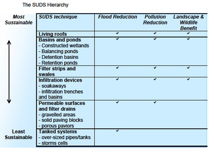
|
(5) Policy NE9: Water quality and environment |
|
Planning permission for development proposals will be granted where they make appropriate space for water, including (as applicable):
|
11.60 Groundwater is an important resource for both water supply and biodiversity as it discharges into surface waters and wetlands, and maintains river and stream flows during dry spells. Most potable water (water which is safe to drink) in North Hertfordshire is abstracted from the ground. As a consequence it can be vulnerable to pollutants. It is therefore important to protect these water resources from any potential pollutants and recapture as much water run off as possible. Development proposals therefore must demonstrate that available improvements in the efficiency of water use, surface drainage systems and pollution prevention measures have been optimised, and that they have strived to mitigate future problems. Policy NE9; Contaminated Land specifically sets the requirements for contaminated land.
11.61 The policy encourages development proposals to incorporate sustainable water management measures into the design. The policy will ensure that where development takes place that appropriate measures are taken to protect the development against flooding and ensure that the design of the development conserves precious water resources, improves water quality and enhances the natural environment. This will enhance and protect local biodiversity and wildlife corridors and ensure the preservation of acceptable flood flow routes is maintained
11.62 The NPPF[125] emphasises the importance of natural networks of linked habitat corridors to allow the movement of species between suitable habitats and promote biodiversity. River corridors are particularly effective in this way.
11.63 Rivers and watercourses enhance the quality of the environment. Their protection and enhancement will improve the enjoyment of these assets, enhancing biodiversity and make them more resilient to current and future pressures. This can be achieved through the use of buffers alongside watercourses and through restoration projects as part of development schemes.
11.64 Where proposals are considered to affect nearby watercourses or sites that are situated close to a river, the Council will seek river restoration and resilience improvements as part of the proposal. In some instances financial contributions may be appropriate towards these measures the restoration of rivers
|
(6) Policy NE10 : Water Framework Directive and wastewater infrastructure |
|
Planning permission for new development will be granted where;
New development around Stevenage within the Rye Meads Sewage Treatment Works Catchment will need to demonstrate that additional potable water supply and wastewater treatment capacity can be achieved and implemented ahead of development without significant environmental impact, including adverse effects on designated sites. |
11.65 North Hertfordshire is located at the watershed between the Great Ouse and Thames river catchments. Headwaters of river catchments are small which means as a consequence there is very little dilution available for large sewage discharges.
11.66 As a result there is little environmental capacity that can be taken up without causing a breach of statutory environmental targets including the Water Framework Directive (WFD)[126]. Additionally water supply also has implications under the WFD, not just water quality. The Great Ouse and Thames catchments are both highly water stressed. Any proposed increase in groundwater abstraction from the catchment is likely to have implications on compliance with WFD regulations also.
11.67 The WFD is being implemented in the UK largely through River Basin Management Plans (RBMP) which detail the pressures facing the water environment and what actions need to be taken in order for the WFD to be met in each area. For North Hertfordshire this includes both the Thames and Great Ouse RBMPs[127]. Working with the Environment Agency and key stakeholders will be important to deliver future outcomes of these plans and improve the District's water environment.
11.68 The Stevenage Water Cycle Strategy (WCS) requires that for new development to proceed in the area, it will need to be demonstrated that it can be delivered within the water resource and water quality constraints. Developers will need to ensure that additional potable water supply requirements can be met and that waste water will not exceed available treatment capacity. Any necessary upgrades to infrastructure will have to be implemented ahead of the development. Rainwater harvesting and grey water reuse need to be strategically planned across larger sites and a strategy of retrofitting water efficiency features could also take place in the area. Reducing potable demand for water will reduce the consequent loading on the sewerage network.
11.69 In Royston, the Environment Agency and the wastewater undertaker have agreed that in principle a technically feasible engineering solution can be delivered to accommodate all of the growth proposed. Should a new permit be required in order to meet the requirements of the Water Framework Directive, this would involve a tightening of standards and would necessitate a costly upgrade of Royston Sewage Treatment Works.
11.70 Drainage strategies should be used to demonstrate that a proposed development has considered the available surface and foul water drainage options during a scheme's preparation stage to ensure that adequate infrastructure is in place before development commences.
|
(2) Policy NE11: Contaminated land |
|
Planning permission for development affecting contaminated land will be granted where:
|
11.71 The District will be accommodating a significant amount of development during the plan period. This policy supports Policy NE1: Environmental and Landscape Protection in protecting and enhancing the environment in the context of accommodating significant development. As a significant proportion of the District's housing growth will take place on previously developed land, it is important for this Plan to deal with the implications of contamination.
11.72 There are numerous sites in the District which are potentially affected by contamination as a consequence of their historical land uses.
11.73 The policy addresses the protection of the health of end users of proposed developments, as well as the protection of the historic, built and natural environment, including groundwater. The latter is of particular relevance in North Hertfordshire because much of the District's water supply comes from an unconfined aquifer.
11.74 The policy will allow the Council to achieve a consistent and transparent approach to the redevelopment of land where contamination of the ground may be a constraint. It will also help to meet the objectives of the Water Framework Directive. The policy also allows us to approve higher value land uses on sites where serious contamination may make other types of development unviable. In the policy below, the term 'receptors' includes human beings, the historic built environment and the natural environment, including controlled waters as defined in Section 4 of the Contaminated Land Statutory Guidance (DEFRA, 2012)[128].
11.75 The contaminated land assessment / study will need to demonstrate how the site will be safely managed before, during and after development and highlight any remedial action where required. Development must ensure that water quality is not compromised and improvements to water quality will be secured where appropriate, in accordance with the Water Framework Directive.
|
(1) Policy NE12 : Renewable and low carbon energy development |
|
Proposals for renewable and low carbon energy development which would contribute towards reducing greenhouse gas emissions will be permitted subject to an assessment of the impacts upon: i. landscape quality, landscape character and visual amenity, including consideration of cumulative impacts of development; ii. environmental assets; iii. the historic environment, including the impact on the setting of historic assets ; iv. the transport network; v. air quality; vi. aviation interests; and vii. the amenity of residents. In assessing renewable and low carbon energy proposals against the above criteria the Council will give significant weight to their local and wider benefits, particularly the potential to reduce greenhouse gas and other harmful emissions, and the social benefits of community owned schemes where this is relevant. Proposals for decentralised energy schemes associated with development of the strategic sites allocated in the Plan will be encouraged subject to an assessment of the impacts. In all cases, end of life/redundant plant, buildings, apparatus, and infrastructure must be removed and the site restored to its former state or a condition agreed with the Council. |
11.76 The UK Renewable Energy Strategy[129] sets out how the UK will ensure that 15% of all energy will come from renewable sources by 2020. Renewable sources of energy include wind, wave, tidal, hydro or solar power and biomass fuels. Nationally, the increased use of renewable and low carbon technology will contribute to improving energy security, increased economic activity and help to slow down climate change through the reduction of greenhouse gas emissions. The National Planning Policy Framework says that local plans should maximise renewable and low carbon energy development while ensuring that adverse impacts are addressed satisfactorily.
11.77 The Hertfordshire Renewable and Low Carbon Energy Technical Study[130] identifies energy opportunity areas in the District. This may assist developers to choose the appropriate renewable technology, depending on the location of the development. The Study also identified that there may be areas of opportunity to investigate decentralised energy schemes, this could be particularly relevant in those areas where larger scale development may take place. Broadly, decentralised energy schemes refer to energy that is generated off the main grid and can include micro-renewables, heating and cooling. Schemes can serve a single building or a whole community. Although development proposals for renewable and low carbon energy will be supported in appropriate locations, it is also important that development proposals incorporate energy efficient measures to help reduce the demand for energy in the first place.
11.78 Renewable energy technologies evolve rapidly in response to technical innovation and consequently funding regimes can also change significantly. This can result in differing levels of interest in development proposals for renewable technology and indeed changes to where those developments might best be located.
(2) 12 Historic Environment
|
(3) Policy HE1: Designated heritage assets. |
|
Planning applications relating to Designated heritage assets shall be accompanied by a Heritage Assessment/Justification Statement that:
Planning permission for development proposals affecting Designated Heritage Assets or their setting will be granted where they (as applicable):
|
12.1 Designated heritage assets include Scheduled Monuments, Listed Buildings, Conservation Areas and Registered Parks and Gardens. National guidance states that great wright should be given to the conservation of those assets[131].
12.2 including (where appropriate) securing an asset's optimum viable use The Council recognises the significance of designated heritage assets within the District and the contribution they make to defining local character, providing a sense of place and achieving sustainable development. Their conservation and preservation is an important consideration within the planning process and is recognised within specific legislation[132] and national planning policy. The Council will require applicants to assess the significance of the designated heritage asset, including its setting, and justify and detail the impact of the proposal upon the significance of the asset to ensure proposals preserve the significance of assets.
12.3 The NPPF sets out that substantial harm to designated heritage assets should generally be avoided, unless specific exception criteria are met.[133] In some cases where proposals will lead to less than substantial harm to a designated heritage asset, it is necessary to weigh any harm against the public benefits of the proposal including (where appropriate) securing an asset's optimum viable use[134]. and ensure that necessary mitigation measures are identified to minimise any identified harm. Sites allocated in this Plan that have the potential to lead to less than substantial harm to a designated heritage asset and or its setting have been weighed against the public interest test and mitigation or guidance measures are set out in this Plan where necessary[135].
12.4 North Hertfordshire contains forty-four conservation areas. These have been designated due to their particular historic or architectural significance. The conservation area boundaries are shown on the Proposals Map. Particular care will be required when considering the scale, layout, design and materials of development proposals within or adjacent to conservation areas. They must be designed to harmonise with their surroundings and in conservation areas preserve or enhance the character or appearance of the heritage asset. The Council will provide guidance for shopfront design and advertising within conservation areas to encourage high quality design and enhance the character and significance of conservation areas.
|
(6) Policy HE2: Heritage at risk |
|
Planning permission will be granted for proposals that seek to restore or provide new uses for designated heritage assets identified on the national register, or the local risk register maintained by the Council, that are justified and appropriate to the significance of the asset to return a heritage asset to beneficial use. Proposals that harm the significance of heritage assets included on national and local registers will be resisted unless the need for, and the benefits of, the development in that location clearly outweigh that harm, taking account of the assets significance and importance, and all feasible solutions to avoid and mitigate that harm have been fully implemented. |
12.5 |As part of its heritage strategy the Council will maintain and review a list of heritage assets at risk and work with Historic England, owners and occupiers to find new, appropriate uses and solutions to secure the future of heritage assets. Generally the Council will work constructively with landowners to seek to prevent heritage assets from becoming 'at risk' in the first place, trying to find appropriate uses where possible.
12.6 Where possible, planning obligations shall be sought to contribute to the conservation of such assets and legal agreements will be used to ensure the repair of assets alongside new developments. Proposals that lead to substantial harm to, or loss of, the significance shall comply with the test detailed in paragraph 133 of the NPPF.
|
(3) Policy HE3: Local heritage |
|
Permission for the loss of a building of local interest will only be granted where
|
12.7 North Hertfordshire has a rich heritage of designed landscapes and historic buildings, many of which are not designated, but contribute to a strong sense of place and contribute much to the character of historic towns, villages and the wider countryside.
12.8Buildings of local interest are those identified on Registers of Buildings of Local Interest adopted by the Council and are selected based on criteria found in those documents.
12.9Buildings that do not satisfy the criteria for buildings of local interest but which have townscape merit and contribute to the special interest of a Conservation Area are identified as 'positive buildings' and often form notable groups that help to define the streetscape.
12.10As and when a Conservation Area review is undertaken, further additions to the Buildings of Local Interest Register or positive buildings will be identified.
12.11 Where appropriate, the Council intends to continue its programme of producing local lists for each town and parish. This will be in accordance with historic England's published advice for the establishment and management of local lists[136].
12.12 The Council will seek to conserve the character and significance of parks and gardens identified as locally important heritage assets and include these on the Hertfordshire Historic Environment Record or identified on adopted local lists or maps of heritage assets.
12.13 Because of the developing programme for producing local lists and the ongoing potential for discovering assets of interest, the Council will determine development proposals affecting all identified non-designated heritage assets in accordance with the NPPF.
|
(2) Policy HE4: Archaeology |
|
Permission for development proposals affecting heritage assets with archaeological interest will be granted where:
Where archaeological sites have been assessed to meet the criteria for inclusion on adopted registers or maps of locally important heritage assets these shall be treated in the same way as archaeology areas and areas of archaeological significance. |
12.14 Scheduled Ancient Monuments (SAMs) are the most important archaeological and historical sites and are given statutory protection. Historic England is responsible for identifying SAMs and any works on them require special permission from the Government. There are currently 60 SAMs in North Hertfordshire, and this list is under constant review.
12.15 There are also a number of archaeological areas and Areas of Archaeological Significance across North Hertfordshire which, although not nationally recognised or designated are considered to be of local importance. This is because they contain or have the potential for moderate or high archaeological remains within them. Known heritage assets of national and local significance are recorded on the Hertfordshire Historic Environment Record. The Historic Environment Record is a dynamic dataset, which is updated constantly to reflect new discoveries made in Hertfordshire. This data is available to view on the 'Heritage Gateway'[137] .
12.16 This does not mean that areas outside the SAMs or Areas of Archaeological Significance are without archaeological potential, and important archaeological remains may exist elsewhere within the District. The Council will seek to protect other valuable remains throughout the District. From time to time alterations to existing areas of archaeological significance, or identification of new areas will be required based on new data or understanding of significance.
12.17 Where development proposals will affect any of these areas, prospective developers will be required to undertake an archaeological assessment (if necessary with a field evaluation) of the site in line with Government guidance and in consultation with the County Council's Historic Environment Unit. A full report of this recording work and any findings should be submitted to the local planning authority for approval before an application can be determined.
12.18 In the event of previously unknown archaeological remains being uncovered after works have commenced on site, both the Council and Historic England should be informed. Should the remains be deemed important enough to schedule, Scheduled Monument Consent will be required.
[71] 'Sui generis' is a term used to mean any use which does not fall within the use classes defined in the Use Classes Order.
[72] Hertfordshire County Council Employment Land Area of Search SPD (2015)
[73] Town Centre and Retail Study (NLP, 2016)
[74] Paragraph 24 of the NPPF
[75] Annex 2 of the NPPF
[76] North Hertfordshire Town Centre and Retail Study Update (NLP, 2016)
[77] This policy is generally directed at proposals for main town centre uses (as defined in the NPPF). Applications for relevant sui generis uses including petrol filling stations will also be considered against this policy. Proposals for other community uses will be considered against Policy HC1.
[78] Manual for Streets (Department for Transport, 2007). This will be measured as the distance from prospective customers' places of residence to the alternate facility.
[79] The Localism Act (2011) includes powers such as Neighbourhood Development Orders and Community Right to Build. These can require examinations and / or referenda in order to be established.
[80] Paragraph 55 of the NPPF
[81] Paragraphs 28 and 55 of the NPPF
[82] Roads in Hertfordshire – A Guide for New Development (HCC, 2011)
[83] Including advice in Paragraph 32 of the NPPF and Planning Practice Guidance.
[84] Preferred Local Plan Model Testing (AECOM, 2016); Infrastructure Delivery Plan (RS Regeneration, 2016)
[85] Paragraph 29 of the NPPF
[86] Vehicle Parking at New Development Supplementary Planning Document (NHDC, 2011)
[87] Strategic Housing Land Availability Assessment (NHDC, 2016); Housing and Green Belt Background Paper (NHDC, 2016)
[88] As defined in Annex 2 of the NPPF
[89] Stevenage and North Hertfordshire Strategic Housing Market Assessment Update: Volume Two (ORS, 2016)
[90] Local Plan Viability Assessment Update (DSP, 2016); Housing and Green Belt Background Paper (NHDC, 2016)
[91] Planning Obligations SPD (NHDC, 2006)
[92] Paragraph 50 of the NPPF
[93] Stevenage and North Hertfordshire SHMA update (ORS, 2015)
[94] Stevenage and North Hertfordshire SHMA update (ORS, 2015)
[95] The housing types encompassed by this are set out in Figure 38 of the Stevenage & North Hertfordshire Strategic Housing Market Assessment Update: Volume 2 (ORS, 2016)
[96] Under the requirements of Policy HS2, this will normally be on schemes of 25 or more homes.
[97] Building Regulations 2010, Approved Document M: Access to and use of buildings, 2015 edition
[98] North Hertfordshire & Stevenage Strategic Housing Market Assessment Update: Volume 2 (ORS, 2016); Local Plan Viability Assessment Update (DSP, 2016)
[99] Planning Practice Guidance: Housing Optional Technical Standards, Paragraph: 009 Reference ID: 56-009-20150327
[100] Gypsy & Traveller Accommodation Study
[101] Building Futures – A Hertfordshire web-based guide to promoting sustainability in development.
[102] Design SPD (NHDC 2011)
[103] Paragraph 124 of the NPPF.
[104] North Herts Air Quality Planning Guidance Document (2016)
[105] Community Halls Strategy for North Hertfordshire (NHDC, 2011); Indoor Sports Facility Study, (NHDC, 2016)
[106] Paragraph 109 in NPPF.
[107] North Hertfordshire Landscape Study (Character, Sensitivity and Capacity) 2011
[108] North Hertfordshire District Green Infrastructure Plan (2009)
[109] NPPF paragraph 115
[110] Countryside and Rights of Way Act 2000 Section 185.
[111] Government's Planning Practice Guidance 8-004-20140306 paragraph 004.
[112] NPPF paragraph 116.
[113] Government's Planning Practice Guidance 8-004-20140306 paragraph 005.
[114] Countryside and Rights of Way Act 2000 Section 85.
[115] Chilterns Conservation Board position Statement on Development affecting the setting of the Chilterns AONB.
[116] Fields in Trust Guidelines (October 2015) or as superseded, Guidance for Outdoor Sport and Play: Beyond the Six Acre Standard, http://www.fieldsintrust.org/guidance
[117] The Biodiversity Impact Calculator is a tool used to quantify the value of biodiversity at any site and can form an evidence base on required mitigation for a development, the amount of residual biodiversity impact, and if necessary, the amount of require offsite compensation. The current Biodiversity Impact Calculator is available on the Environment Bank website at : http://www.environmentbank.com/impact-calculator.php
[118] Hertfordshire Environmental Forum (2006) A Biodiversity Action Plan for Hertfordshire, http://www.hef.org.uk/nature/biodiversity_vision/index.htm
[119] Hertfordshire Environmental Forum (2006) A Biodiversity Action Plan for Hertfordshire, http://www.hef.org.uk/nature/biodiversity_vision/index.htm
[120] Please refer to the list held by the Hertfordshire Environmental Records Centre for the current list of designated Wildlife Sites.
[121] The Biodiversity Impact Calculator is a tool used to quantify the value of biodiversity at any site and can form an evidence base on required mitigation for a development, the amount of residual biodiversity impact, and if necessary, the amount of require offsite compensation. The current Biodiversity Impact Calculator is available on the Environment Bank website at : http://www.environmentbank.com/impact-calculator.php
[122] Hertfordshire Environmental Forum (2006) A Biodiversity Action Plan for Hertfordshire, http://www.hef.org.uk/nature/biodiversity_vision/index.htm
[123] Currently Hertfordshire County Council
[124] Water Resources Act 1991
[125] Paragraph 109
[126] For information on the Water Framework Directive, see: http://www.environment-agency.gov.uk/research/planning/33362.aspx
[127] For information see: https://www.gov.uk/government/publications/great-ouse-catchment-flood-management-plan
[128] Currently defined in Section 4 of the DEFRA Contaminated Land Statutory Guidance, April 2012.
[129] Department of Energy and Climate Change, 2009
[130] Hertfordshire Renewable and Low Carbon Energy Technical Study, AECOM, July 2010
[131] NPPF paragraph 132
[132] Planning (Listed Buildings and Conservation Areas) Act 1990
[133] NPPF paragraphs 132 and 133
[134] NPPF paragraph 134
[135] See Policies SP14 to SP19 and the Communities section for guidance and mitigation. The Housing and Green Belt Background Paper (NHDC, 2016) sets out how the strategy in this Plan has been balanced against heritage and other harms.
[136] Historic England (2016) Local Heritage Listing. Historic England Advice Note 7.