Local Plan 2011-2031 Proposed Submission Draft
SECTION FIVE - IMPLEMENTATION MONITORING AND REVIEW
(10) 14 Delivery
14.1 One of the key tests that the Local Plan must meet is to ensure that it is effective. This means that it should be capable of being delivered within the plan period and based on effective joint working on cross-boundary strategic priorities. This section demonstrates how this will be achieved through implementation and monitoring.
Implementation
14.2 Alongside the Council there are many organisations that will contribute towards the delivery of the aims of the Local Plan. For example:
- Hertfordshire County Council has a significant role to play in relation to education and highways alongside other functions;
- North Hertfordshire Homes and other providers in relation to the delivery of affordable housing;
- The health authorities will need to ensure there are the right medical facilities at the right time;
- the water companies and the Environment Agency in relation to water supply and treatment;
- The development industry will play a significant role in bringing development forward, together with the provision of or contribution towards infrastructure alongside other forms of funding;
- North Hertfordshire has seven neighbouring authorities, each producing their own local plans. We will ensure that these plans complement each other and address issues which cross local authority boundaries;
- Communities can also choose to become neighbourhood planning areas to help shape and deliver development and infrastructure in their areas;
14.3 The Council will continue to work in partnership with these and other relevant bodies and will put further mechanisms in place to ensure delivery within the plan period. Some of the key methods and schemes that will be used to ensure delivery are summarised below:
Infrastructure Delivery Plan and Key Infrastructure:
14.4 Ensuring that existing and new communities are sustainable involves a co-ordinated and flexible approach to the provision of infrastructure. An Infrastructure Delivery Plan (IDP) has been prepared as a background document to support the Local Plan and assist as a delivery mechanism[150].
14.5 It takes into account the growth targets and sets out the infrastructure that is likely to be needed to support growth within the District to 2031. We have worked with a variety of infrastructure providers to understand likely future requirements.
14.6 Predicting infrastructure needs so far into the future is not straightforward. The precise detail of most development schemes is not known and the nature of public services can change along the way.
14.7 The IDP represents current strategic thinking and provides a guide for planning future infrastructure. It will continue to be updated on an iterative basis over the lifetime of the plan to reflect change.
14.8 Notwithstanding this point, the IDP has identified a number of areas where significant interventions will be required to support the delivery of the plan:
- Strategic Transport – The scale of growth within the District will result in a significant number of new trips on a transport network that is already under stress in certain areas. Congestion issues are particularly focused within Hitchin and junctions relating to the A1(M). Not only as a result of growth in North Hertfordshire, but also in relation to existing issues and development in nearby authorities. There is a clear need to focus on promoting sustainable travel modes to limit the impacts of growth whilst delivering significant physical mitigation measures. Our transport modelling has helped to identify 11 specific schemes that will be required in the District over the period to 2031 as well as other schemes in neighbouring Stevenage which are influenced by this Plan's proposals[151].
- School Places – The County Council believe that, in many areas, existing schools are reaching, or at, capacity. This is addressed in this Plan through the provision of new schools or school expansion on Strategic Housing Sites and elsewhere. Schemes will need to demonstrate acceptable education solutions in order to gain planning permission;
- Sewerage Infrastructure – Our evidence has highlighted potential capacity issues with wasterwater treatment capacity, particularly at Royston Sewage Treatment Works and Rye Meads Sewage Treatment Works. Technical solutions are possible and further detailed discussions are taking place with the water companies and the Environment Agency to inform appropriate mitigation measures.
14.9 Whilst these issues are not absolute constraints to the Local Plan, continued and proactive engagement with relevant parties, such as the developers, Highways Agency and Highways Authority, the Local Education Authority, the Environment Agency and Water companies and the Hertfordshire Local Nature Partnership is fundamental in achieving appropriate solutions.
14.10 The IDP should be referred to for a full programme of mitigation measures required to support the Local Plan. Delivery of these schemes will be monitored on an on-going basis through our Authority Monitoring Reports.
Developer Contributions and Other Funding Sources:
14.11 The development industry will also be expected to reasonably contribute to the delivery of the Local Plan. Our approach to securing infrastructure and mitigation measures through new development is set out in Policy SP7. At the same time, it is acknowledged that the sites and schemes identified in this Plan are unlikely to make sufficient contributions to support the full range of infrastructure envisaged by the IDP.
14.12 This does not mean that development cannot occur. The Council will continue to work in partnership with other agencies to enable much needed funding for infrastructure. This might include:
Local Enterprise Partnerships (LEPs) – LEPs are partnerships between businesses and local authorities set up by Government to support growth. North Hertfordshire is covered by two separate LEPs – Hertfordshire and Greater Cambridge Greater Peterborough.
LEPs received substantial funding settlements from central Government to meet strategic growth priorities and are responsible for then identifying specific projects which contribute to their aims;
Central funding – although a number of bodies are likely to 'bid' to the District Council for infrastructure contributions in the form of developer contributions, they also have access to their own funding programmes. Major hospital works, for example, are often ultimately funded directly through the Department for Health. Highways England similarly receive direct settlements to deliver key projects. This includes the proposed conversion of the A1(M) between Junction 6, near Codicote, and Junction 8, near Little Wymondley to a 'SMART' motorway. This will provide additional capacity by creating a third lane in each direction through hard-shoulder running at peak times.
Grants and programmes – Where individual projects meet specific objectives, they can receive grant funding. Well known examples include lottery funding, particularly where there are heritage or health benefits, and programmes currently run by the European Union. North Hertfordshire, for example, benefits from access to the Eastern Plateau Fund which helps to support economic development in rural areas.
Development Management through the Planning Application Process
14.13 This is a key mechanism for ensuring development is delivered appropriately. The Council has a primary role in determining planning applications and ensuring that they are delivered in accordance with this Local Plan, other elements of the statutory Development Plan, national policy and legislation[152].
14.14 A number of schemes have been worked up in tandem with this Plan to ensure early delivery and compliance with policy. A pro-active approach will continue to be taken to all schemes. This should not only promote delivery, but should also ensure that developers are fully aware of how their planning applications will be assessed. Appropriate conditions and/or planning obligations will be used to ensure delivery of infrastructure and appropriate mitigation measures are put in place for schemes.
14.15 An estimate of the number of new homes has been provided against each site. However, as set out in the policies of this Plan, these figures are not binding and the Development Management process will be used to explore design-led solutions on individual sites. Where it proves possible to deliver higher numbers of homes within the policy framework of the plan, this will be supported and will contribute greater flexibility to the plan by increasing the 'buffer' of new homes over and above the targets in Policy SP8.
Supplementary Planning Documents (SPDs), other plans and documents:
14.16 Where appropriate, local authorities can set out further guidance that supports the policies in the Local Plan. Formal guidance takes the form of Supplementary Planning Documents (SPD). Current guidance includes that on parking standards and design.
14.17 There are also Town Centre Strategies for each of the four towns while communities are choosing to prepare Neighbourhood Plans for their area to assist implementation.
14.18 The Council will review SPD and other guidance on an on-going basis throughout the lifetime of this Local Plan.
Council Owned Land and Property
14.19 The Council can use its own assets to assist in delivery and promote growth. Protection and improvement of environmental assets on Council owned land will also be important.
Acquisition powers
14.20 The Council can use its resources to assemble land and sites. However, it is envisaged that almost all of the development that is set out in, or will by controlled by, this Plan will be delivered by third parties.
14.21 Recent legislation provides greater opportunities for local communities to take control of assets in their local areas. This includes the community Right to Bid which gives local people additional time to develop a strategy where local facilities which have been identified as an Asset of Community Value are earmarked for sale by their owners.
14.22 As a last resort, the Council's Compulsory Purchase powers can be used to ensure implementation of the policies and priorities of the Local Plan. This includes for buildings identified as Assets of Community Value which are perceived to be under threat. However, the Council's preferred approach remains pro-active negotiation with, and advising of, landowners, developers and other relevant parties to assist the delivery of schemes and the retention of important local facilities.
14.23 Where a local community considers that an Asset of Community Value is under threat and that they may wish the request the use of the Council's Compulsory Purchase powers, they should contact the Council for further advice on the appropriate procedure(s) and any financial implications.
Monitoring
14.24 A monitoring framework will allow us to assess whether the policies in this Plan are being successfully implemented. This will be set out in, and form the basis of, our authority monitoring reports (AMRs) that we must produce annually.
14.25 The AMR will show whether policies are working or having the right effect. It will demonstrate whether we are meeting the targets we have set for ourselves, or on track to do so.
14.26 As well as tracking the direct effects of implementing the plan, monitoring also allows us to consider the wider social, economic and environmental impacts. There is considerable cross-over here with the requirements of environmental assessment legislation which requires on-going monitoring of significant effects[153].
14.27 The table below sets out some of the key indicators and targets (where applicable) that will be measured. These will be supplemented by other indicators and contextual data on matters such as unemployment rates, retail vacancies and travel choices.
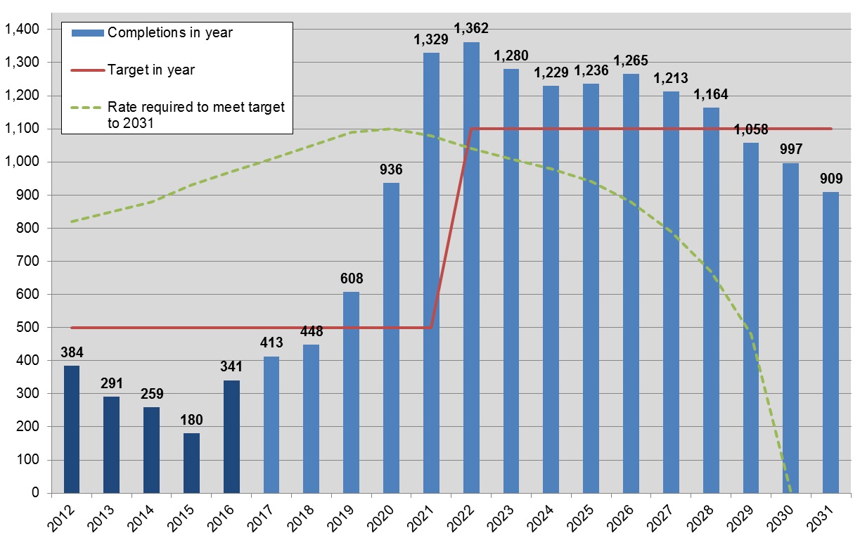
14.28 The table is followed by a housing trajectory setting out how the delivery of new homes is currently anticipated to occur over the plan period. Figure 6 over-page shows the anticipated housing trajectory. This will be kept up-to-date in future monitoring reports. This programme of delivery will allow the plan to demonstrate a five-year land supply at the point of adoption and, subsequently, on an on-going basis[154].
14.29 Although many of these indicators will be influenced by the implementation of this plan they are also subject to wider forces, such as the state of the economy, and the choices made by individuals, businesses and other service providers. Failure to meet these targets should not necessarily be read as a failure of the plan and future monitoring reports will identify where external factors have influenced performance.
Table 2: Key Indicators and Targets for Monitoring Policies
|
Strategic Policy |
Indicator |
Target |
|
SP1 |
Number of designated neighbourhood planning areas |
(none) |
|
SP1 |
Number of Neighbourhood Plans submitted and compliant and made |
(none) |
|
SP2 |
Housing completions by settlement type |
For at least two-thirds of development to occur within or adjoining identified towns |
|
SP3 |
Employment floorspace completions by location |
For at least 90% of business development to occur within designated employment areas or allocated employment sites |
|
SP4 |
Retail floorspace completions by location |
For at least 75% of retail development to occur within identified centres |
|
SP4 |
% of primary frontages in A1 retail use |
For at least 66% of units and floorspace within the primary frontage to remain in A1 use |
|
SP4 |
Land-use in local centres |
For at least one unit in all centres to remain in use as a shop |
|
SP4 |
Services available in villages |
(none) |
|
SP7 |
s106 / CIL Monitoring |
(none) |
|
SP7 |
Infrastructure delivery |
To ensure the timely delivery of infrastructure necessary to support the plan |
|
SP8 |
Housing completions |
For housing completions to remain broadly aligned to the trajectory established in the plan |
|
SP8 |
Five-year land supply |
To maintain a five-year land supply at all times |
|
SP8 |
2031 land supply |
To ensure projected completions over the period to 2031 will meet or exceed the housing targets of the plan |
|
SP8 |
Housing completions on previously developed land |
For at least 20% of homes over the plan period to be on previously developed land |
|
SP8 |
Affordable housing completions |
For at least one-third of housing completions to be for affordable housing |
|
SP8 |
Affordable housing supply by scheme type |
For affordable housing to meet target levels of provision |
|
SP8 |
Housing completions by size |
To supply a broadly even split between small (1- or 2-bed) and large (3+ bed) properties |
|
SP11 |
Applications permitted against the advice of the Environment Agency or Lead Local Flood Authority |
To not permit development against the advice of these statutory agencies |
|
SP12 |
Number and area of designated biodiversity sites |
No loss of designated sites in terms of number or area |
|
SP12 |
Open space provision in new development (permissions) |
For new development to achieve current open space standards |
|
SP12 |
Open space provision per 1,000 population |
For district-wide provision to achieve current open space standards |
|
SP13 |
Number and status of Conservation Areas |
No loss of designated areas and for all areas to be supported by up-to-date appraisals |
|
SP13 |
Number and status of Listed Buildings |
No loss of Listed Buildings and for no buildings to be at risk |
Review
14.30 The Government expects plans to be regularly reviewed, preferably every five years[155] and we will need to update our Local Plan more regularly than has happened in the past. National guidance recognises that plans can be reviewed in whole or in part to respond flexibly to changing circumstances[156]. We will use the monitoring framework, set out above, to keep the effects of this Plan under review.
14.31 Where monitoring shows that we are consistently failing to meet relevant targets, or are unlikely to do so in the future, or that wider conditions have changed to the extent that the strategy in this plan is no longer appropriate, we will initiate a review of the Plan that relates to those specific issue(s) identified.
14.32 In addition to our monitoring, we recognise that other events may trigger a future review of the Plan. Local plans should normally set out where development will occur over a 15-year period from the point of adoption[157]. This Plan shows how we will meet our needs over the period to 2031, 13 years from the anticipated date of adoption.
Figure 6: North Hertfordshire housing trajectory 2011-2031
14.33 We already recognise that further work is required to ensure we meet our needs in full in the period beyond 2026. However we believe that, due to the progress already made on these issues, the approach set out in this Plan is the most appropriate one for North Hertfordshire.
14.34 We consider that this Plan makes maximum use of reasonable and available development sites at the time of writing. On-going processes are likely to supplement the range of spatial options available in North Hertfordshire in the period after 2026. It is considered most appropriate to let these 'run their course' in order to properly inform longer-term planning.
14.35 The Council has resolved to fully explore the possibilities of a new settlement within the District. Our work to date recognises the long-term nature of these projects. Further work will be initiated to identify potential locations where any new settlement(s) might be located and this continues to be progressed.
14.36 At the same time, future decisions by other bodies may significantly influence future options for growth in North Hertfordshire. We will continue to work with central government and other relevant agencies to better understand the likely nature of potential projects[158].
14.37 We currently consider it most likely that the outcomes of these deliberations and the new settlement process will be reflected in a full review of the Plan. Our present intention is that the next full review of this Plan will be completed by the mid-2020s at the latest. It will roll the Plan forward to a new time horizon of at least 2041 and deliver specific additional land and sites that we already recognise will be needed.
14.38 This Plan recognises the requirements of the Duty to Co-operate and makes a positive contribution towards unmet development needs from Luton. This maximises the contribution that we feel can be made from that part of the District within the Luton Housing Market Area (HMA).
14.39 We are actively working with the other authorities in the HMA – Luton, Central Bedfordshire and Aylesbury Vale – to understand the extent to which the market area as a whole will be able to accommodate development needs[159]. If there proves to be insufficient capacity within the Luton HMA, it will be necessary to look further afield for potential solutions. This would be likely to involve a number of authorities.
14.40 We will continue to engage constructively in this process and, if necessary, consider how best to reflect the outcomes. Dependant on the nature of any issues raised, it may be possible to deal with this through partial or focused reviews of any relevant policy/ies.
14.41 Beyond these defined events, there may be changes in circumstances that we cannot currently foresee but which have a substantial impact upon the District. This might be a major change to the way in which the planning system operates or the cancellation of a key project required to support growth. We will determine the most appropriate response as and when any such circumstances arrive.
[150] North Hertfordshire Infrastructure Delivery Plan (R S Regeneration, 2016)
[151] AECOM transport modelling (AECOM, 2016)
[152] Planning applications must be determined in accordance with the Development Plan unless material considerations indicate otherwise. As well as this Local Plan, the Development Plan includes any Neighbourhood Plans produced by local communities and the Waste Local Plan and Minerals Local Plan produced by Hertfordshire County Council.
[153] Sustainability Appraisal of the North Hertfordshire Local Plan (CAG, 2016)
[154] Further information on the calculation of five-year land supply is set out in the Housing and Green Belt Background Paper (NHDC, 2016)
[155] As set out in the Government's Technical consultation on implementation of planning changes (DCLG, 2016)
[156] Paragraph 153 of the NPPF
[157] Paragraph 157 of the NPPF
[158] The Hertfordshire LEP, for example, has identified a long-list of potential strategic transport projects over the period to 2050 which could unlock new locations or directions for growth.
[159] Luton Housing Market Area Growth Study (Land Use Consultants, forthcoming)