Local Plan 2011-2031 Proposed Submission Draft
(48) SECTION ONE - INTRODUCTION AND CONTEXT
1 Introduction
1.1 Planning is about making important decisions affecting the environment and character of our towns, villages and countryside and ensuring that development happens in the right place at the right time. These decisions affect how we live and work and how we feel about places.
1.2 The process of preparing local plans and controlling development are firmly based within a legal framework set by the Government. The legislation and national planning advice state that all local authorities should have an up-to-date local plan. The last District Local Plan was adopted in 1996. North Hertfordshire District Council's new Local Plan directs where new development will take place across the plan area, describes what changes will occur and identifies how our towns and villages will be shaped in the future.
1.3 This Local Plan seeks to address the key issues facing North Hertfordshire and will set a strategic vision and spatial strategy for the District over the period 2011 to 2031. The Local Plan contains five main sections, not including the appendices. A separate Local Plan Proposals Map is published alongside the Local Plan to show the spatial implications of policies:
- Section One: Introduction and Context – this section explains the planning system and provides an overview of North Hertfordshire and the wider area. It also sets out the key challenges and issues facing the District.
- Section Two: Spatial Strategy and Strategic Policies – This section sets out the spatial strategy and vision for the future of the District and links this to the strategic policies which provide the guidance on the main issues that the Plan seeks to address. It sets out our overall approach to topics such as housing, employment, Green Belt and countryside. It also contains a separate policy for each of the Strategic Housing Sites (defined as sites of 500 or more homes) which will make a substantial contribution towards housing requirements over the plan period.
- Section Three: Development Management Policies – This section covers the detailed requirements that new development must meet to be granted planning permission. It includes issues such as open space, design and car parking.
- Section Four: Communities – This section sets out the site allocations for each community on a parish / town basis. It identifies the detailed site-specific criteria for each local housing allocation. Retail and employment allocations are also identified.
- Section Five: Implementation, Monitoring and Review – This section sets out how the proposals in the Plan will be delivered. It identifies key supporting infrastructure and the partners that will help to deliver it. It sets out a monitoring framework that will be used to ensure that our vision and strategic policies are being met and sets out an approach to a future review of the Plan.
1.4 It is important to note that the policies and supporting text in this Plan are inter-related and need to be read together when considering a specific proposal or issue. This Local Plan supersedes the saved policies from the 1996 North Hertfordshire District Local Plan No 2 (with Alterations). Appendix 1 provides a list of policies that have been superseded. Appendix 2 provides a list of Local Plan designations as shown on the Proposals Maps and where to view other designations which policies in the Local Plan refer.
The Planning Framework:
National Policy and Guidance
1.5 The National Planning Policy Framework (NPPF)[1] published in 2012 sets out the Government's planning policies for England and must be taken into account along with other national planning policy in the preparation of local and neighbourhood plans and in determining planning applications. The NPPF is supplemented by detailed Planning Practice Guidance (PPG), released in 2014, which provides additional detail on certain topics. Local plans must be consistent with national planning policy to pass examination.
1.6 One of the key elements of the NPPF is the presumption in favour of sustainable development. Local plans must be based on and reflect the presumption and include clear policies setting out how the presumption should be applied locally. It also states that local plans should meet objectively assessed needs for housing, business and other requirements, with sufficient flexibility to adapt to rapid change, unless the adverse impacts of doing so would significantly outweigh the benefits or other specific policies in the NPPF indicate that development should be restricted.
1.7 In relation to local plans, matters covered by the NPPF include (but are not limited to) requirements to:
- Properly assess the need for new development (known as objectively assessed needs) and planning to meet these insofar as is consistent with the framework;
- Where appropriate, carry out these assessments with regard to market areas which may cross administrative boundaries and ensuring that development needs across these wider areas are also met;
- Protect existing Green Belt and only alter it in exceptional circumstances;
- Identify what infrastructure will be required to support planned development;
- Address issues such as climate change and ensure a positive approach to the conservation and enhancement of natural and historic environments; and
- Where potential harm to relevant natural or historic assets may occur, consider this against the public benefits that may arise from any proposed development.
Duty to co-operate
1.8 Another important element of the National Planning Policy Framework is the Duty to Co-operate. The 'Duty-to-Co-operate' was introduced via the 2011 Localism Act. Public bodies have a legal duty to co-operate on strategic planning issues that cross administrative boundaries, with local planning authorities working together to meet development requirements which cannot wholly be met within their own areas. Local planning authorities will be expected to demonstrate evidence of having effectively cooperated to plan for issues with cross-boundary impacts when their local plans are submitted for examination.
1.9 The Council has sought to engage constructively and on an on-going basis with other neighbouring authorities and public bodies throughout the preparation of the Plan. This includes the joint commissioning and sharing of evidence base studies and the identification of infrastructure requirements. In particular the Council has worked with Stevenage Borough Council, Luton Borough Council and Central Bedfordshire District Council in terms of addressing housing and employment requirements. The Council has also worked with Hertfordshire County Council and other national bodies in terms of transport and other infrastructure requirements.
Relationship to Neighbourhood Plans
1.10 Neighbourhood plans have been introduced by the Localism Act 2011 and enable local communities to shape development in their area. These are plans produced by a parish council or a neighbourhood forum. Towns and parishes also have the option of working together to prepare a joint neighbourhood plan. If a neighbourhood plan is prepared, independently examined, is supported by the Council and receives a majority vote in a referendum it becomes part of the statutory development plan for that neighbourhood and is used when determining planning applications, alongside the Local Plan.
1.11 In order for a neighbourhood plan to become part of the statutory development plan for an area it must:
- have appropriate regard to national policy and guidance;
- contribute to the achievement of sustainable development;
- be in general conformity with the strategic policies contained in the development plan for the area; and
- not breach and be otherwise compatible with EU obligations.
1.12 The first step in preparing a neighbourhood plan is to define a neighbourhood area. There are currently eleven neighbourhood planning areas designated within the District with another two communities considering preparing a neighbourhood plan. Those plans under preparation include the parishes of Pirton, Kimpton, Ashwell, Codicote, Barkway and Nuthampstead, Ickleford, St Ippolyts, St. Pauls Walden, Wymondley, Preston and Knebworth.
1.13 National policy makes it clear that once a neighbourhood plan has demonstrated its general conformity with the strategic policies of the relevant local plan, and has been brought into force, the policies it contains will take precedence over existing non-strategic policies in the local plan for that neighbourhood, where they are in conflict.
1.14 This local plan clearly distinguishes between strategic and non-strategic policies to assist in the development and interpretation of Neighbourhood Plans.
1.15 Local planning authorities have a general duty to support communities producing neighbourhood plans. The Council is committed to neighbourhood planning as a process, and offers support and guidance to parish councils in preparation of their plans.
Appraisals and Assessments
1.16 The Local Plan must undergo a Sustainability Appraisal (SA) and a Strategic Environment Assessment (SEA) as part of its preparation. These are required under both national and European law. SEA takes into consideration the likely impacts of the Plan on the environment. The SA appraises the likely significant environmental, social and economic effects of the proposed policies in the Plan and how these can be mitigated and controlled. These assessments are normally carried out as a single process and this approach has been taken.
1.17 This Plan is accompanied by a sustainability appraisal report. The findings of the assessments have fed directly into the development of the policies. For the strategic policies reference is made in the Plan to the most important findings of the report.
1.18 In preparing the Local Plan, we have also carried out a Habitat Regulations Screening Assessment to determine whether the Plan is likely to have any significant effects on known European wildlife habitat sites. This assessment concluded that, within the measures and safeguards included in this Plan, the scale and type of development being proposed is unlikely to have a significant effect upon and European sites[2].
Statement of Community Involvement
1.19 The Local Plan has been prepared following consultation with the local community in accordance with the Council's Statement of Community Involvement[3] which sets out when the Council will consult the community in relation to the Local Plan, how the Council will engage with the community and who the Council will involve in that consultation. Consultation on the Local Plan has also been carried out in accordance with requirements set out in the Town and Country Planning (Local Planning) (England) Regulations 2012.
Local Development Scheme
1.20 The Local Plan has also been prepared in accordance with the Council's Local Development Scheme[4]which provides information about the programme for preparing planning documents to be prepared as part of the Local Plan. This includes documents that have been produced already and a timetable for the production of future documents.
The Local Plan Evidence Base
1.21 All local plans are required to have an evidence base to draw from during their preparation to ensure that accurate, robust and up-to-date information is available to formulate meaningful and effective policies. The Council has prepared a wide-ranging evidence base for the Local Plan. This is listed on the Council website and is updated on an ongoing basis.
Previous Consultation:
1.22 The policies and proposals within this Local Plan have evolved through a number of previous consultation stages.
1.23 Under new legislation in 2004 with the introduction of the Planning and Compulsory Purchase Act, the local plan process was renamed the 'Local Development Framework' (LDF). The contents of the LDF were guided by regional plans, formally known as Regional Spatial Strategies (RSS). These set out development targets and strategic policies for the local planning authorities in their area. North Hertfordshire was located within the East of England region and an RSS for this area was adopted in 2008.
1.24 The Council published several consultation papers as part of the LDF between 2005-2009 to conform to the emerging and adopted proposals of the RSS, including:
- Core Strategy and Development Policies Issues & Options (2005);
- Core Strategy Preferred Options (2007);
- Development Policies Preferred Options (2007);
- Stevenage & North Herts Action Plan Issues and Options (2007, jointly with Stevenage Borough Council);
- Land Allocations Issues & Options (2008); and
- Land Allocations Additional Suggested Sites Issues & Options (2009)
1.25 The publication of the NPPF in March 2012, followed by the eventual revocation of the East of England Plan in January 2013 effectively 'reset the clock' for North Hertfordshire's Local Plan. A decision was made to merge the work on the emerging core strategy and the land allocations into a single local plan. As a consequence of these events, the Council became responsible for determining strategic planning matters formerly set out in the RSS, such as the setting of housing targets for the area.
1.26 Since March 2012, the Council has carried out three public consultations on a new Local Plan for North Hertfordshire. Given the significant changes above, it is these consultations that are viewed as marking the formal preparation of this Plan. This was in response to the evidence work carried out in assessing the objectively assessed need for housing and requiring consultation on proposed housing sites. These included the:
- Housing Options Growth Levels and Locations 2011-2031 (February 2013)
- Housing Additional Local Options (July 2013); and
- Local Plan Preferred Options (December 2014)
1.27 All three of these consultations saw relatively strong responses from residents, businesses, organisations, elected representatives and other stakeholders. All representations have been assessed and summarised and have been key in shaping this document. The Statement of Consultation[5] sets out how the Council has taken into account the comments it has received and forms part of the Council's evidence base.
(5) 2 A Picture of North Hertfordshire
Figure 1: North Hertfordshire in Context:
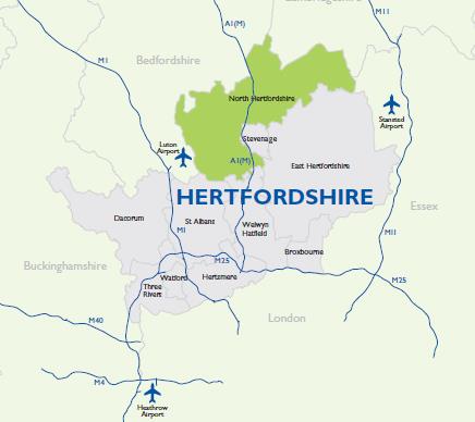
2.1 North Hertfordshire is a predominantly rural district covering approximately 375 square kilometres of land and is the most northern district within the County of Hertfordshire. The District is bounded by eight local authority areas – Stevenage, East Hertfordshire, St. Albans and Welwyn Hatfield within Hertfordshire, but also Luton, Central Bedfordshire, South Cambridgeshire and Uttlesford (Essex). Stevenage and Luton are relatively small in size and primarily urban by nature.
2.2 North Hertfordshire is characterised by a number of small to medium sized towns with a range of facilities and smaller settlements located within open countryside. The main settlements within North Hertfordshire are Hitchin, Baldock, Royston and the world's first Garden City, Letchworth, each representing a significant focus for employment and housing. Most of the Great Ashby estate on the edge of Stevenage lies in North Hertfordshire. There are also about 40 villages and hamlets. Although there is no one dominant centre serving the District, there is a high degree of interdependency between the various towns and villages, as well as with surrounding larger towns like Stevenage, Luton, Milton Keynes, Cambridge, Welwyn Garden City and London.
2.3 A large proportion of the rural area of the District is covered by Green Belt, with the remainder classified as rural area beyond the Green Belt. North Hertfordshire has two areas of Green Belt, the London Metropolitan Green Belt covering Hitchin, Letchworth Garden City, Baldock, Stevenage and nearby settlements, and the Luton Green Belt covering parts of the west of the District[6].
2.4 The District is strategically positioned with good rail and road connections. It is less than 40 miles from central London. The five railway stations within North Hertfordshire provide direct services north to Peterborough, north-east to Cambridge and King's Lynn, and south to London and Hertford. There are also services to Stevenage that offers access to the North East and Scotland. However no rail links from the District to the west exist, meaning towns like Luton and Milton Keynes are less accessible via public transport.
2.5 The A1 linking London to the North also passes through the District, as does the A505 running from east to west. Other main roads serving the local authority area include the A600, A602 and A507, while the two airports of Stansted and Luton are also situated in close proximity to the District as shown on Figure 2 below.
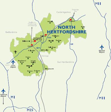
Figure 2: North Hertfordshire in detail
Population & Distribution
2.6 North Hertfordshire is a diverse area. The total population figure for North Hertfordshire, from the 2015 Mid-Year Estimates, was 131,696 (males = 64,621 and females = 67,075)[8]. Over 70% of the population live in the four main settlements of Hitchin, Letchworth Garden City, Royston and Baldock
2.7 The District age profile differs from the East of England profile as there is a lower proportion of 15-29 year olds (North Hertfordshire 15.7% compared to East of England 17.8%). There are, however, more in the age groups from 30-54 (North Hertfordshire 36 % compared to East of England 33.6%)[9].
2.8 Official statistics indicate that the population is likely to increase over the next 15 years by just over 24,000 residents (population estimate at 2031 – 153,400)[10]. This is due to a combination of factors, including people living longer, changes in social patterns, and the attractiveness of the District as a place to live. This will put considerable pressure not just on our housing numbers but on vital social support mechanisms such as schools and GP surgeries as well as our transport infrastructure.
Ethnicity
2.9 The District has a diverse population, with a black and minority ethnic population comprising 10.5% of the total population, compared with 14.6% for England, and 9.2% for the East of England region.
Economic Activity and Inactivity
2.10 8 in 10 (86.9%) of North Hertfordshire's 16-64 year olds are economically active (in or seeking employment) compared to a national figure of 77.8%[11]. The unemployment rate in North Hertfordshire is 3.4%; this is below the East of England figure (3.8%) and below the national rate (5.1%)[12]. Approximately 1 in 5 (13.1%) of North Hertfordshire's 16-64 year olds are economically inactive[13].
Deprivation
2.11 According to the 2015 Index of Multiple Deprivation, North Hertfordshire is relatively affluent compared to other local authority areas. The District ranks 271st out of 326 local authority areas in England (1 being the most deprived)[14]. None of the District's population lives in areas within the bottom 10% of Super Output Areas (SOA) nationally, i.e. in the most deprived parts of the country. North Hertfordshire does however have four areas in the next two cohorts, i.e. those which are in the top 30% are seen as being most deprived, this includes one area in Hitchin and three in Letchworth Garden city.
Health
2.12 On the whole the quality of life in North Hertfordshire is good. Life expectancy in North Hertfordshire is similar to the national figure; the male rate is currently 80.4 years compared to 79.4 years for England, and the female equivalent is 83.2 years compared to 83.1 years nationally. Life expectancy is 3.7 years lower for men in the most deprived areas of North Hertfordshire than in the least deprived areas[15].
2.13 Projected population changes for North Hertfordshire to 2031 and beyond shows the impact that higher life expectancy has in regard to the age of the general population, with a higher proportion of our residents living between the 70 to 90+ age bands who will require differing degrees of support in terms of health and social care.
2.14 Adult and child obesity rates in North Hertfordshire are below the national and regional averages. 19.1% v 23.0% for adults and 12.6% v 19.1% for children; however, these figures still present a key challenge for the District[16].
Economy:
2.15 Like most areas North Hertfordshire did not escape the detrimental affects of the economic downturn in 2009 and many variables including unemployment and job growth figures suffered as result. Figures have only recently returned to pre-2008 levels and the local employment environment is improving and the figures are moving in the right direction. It is estimated that there are around 48,800 jobs[17] in North Hertfordshire.
2.16 There is a higher concentration of people working in the District employed in sectors such as manufacturing, construction, retail, motor trades, property, entertainment and recreation. Many higher skilled residents commute out of the District for employment. Nonetheless sectors such as finance & insurance and information & communication make a substantial contribution to the District's overall economic output, although not employing a huge number of people. These represent opportunities for future expansion and development[18].
2.17 The District hosts a number of internationally important businesses in the environmental technologies, insurance and electronics, as well as companies in pharmaceutical technologies, advanced engineering. Information technology and in the service and business support sectors.
2.18 The District has a working age population of 81,700 of which 71,800 are economically active. The majority of these are employees and work full-time but a small proportion of the population are self employed (10.4%).
2.19 In 2015 the median gross pay for full-time workers in the area (residence based) was £637.3 per week. This was considerably higher than the median earnings of those living in the East of England region (£551.0 per week) and the National Average (£529.6 per week), reflecting the high earnings associated with the proportion of the public that commute out of the District.
2.20 15.7% of the population do not have access to a car. This is much lower than the national figure (24.9%) and slightly lower than regionally (17.7%).
Housing:
2.21 At the start of the plan period in 2011, there were approximately 55,000 homes in North Hertfordshire. Almost one-quarter of homes in North Hertfordshire were detached houses. This proportion was slightly higher than both the Hertfordshire county and national figures. Conversely, the proportion of flats (including converted houses) was slightly lower[19].
2.22 House prices in the District are well above the regional and national averages, although slightly below the average for Hertfordshire which is skewed significantly upwards by prices in areas such as St Albans. The average cost of a home in the District is around £350,000, meaning prices are around one-quarter higher than the national average[20].
2.23 Plainly, these district-wide figures mask some fairly significant variations within and between North Hertfordshire's towns and villages.
2.24 In the ten-year period preceding this Plan, almost 5,500 new homes were built. The level of housing completions was highest over the period 2001-2008. On average, more than 600 homes were built each year during this period, with more than 700 new homes built in both 2001/02 and 2007/08. However, the completion of work at Great Ashby coincided with the financial 'crash' and general downturn in the property market. Since 2008, housing completion rates in the District have almost halved to around 330 new homes per year[21].
2.25 There are currently more than 1,600 households on the local authority housing register awaiting assistance with their housing needs[22].
Natural and Built Environment:
Natural environment
2.26 The natural environment of North Hertfordshire contributes to its character and distinctiveness. North Hertfordshire has a diverse range of green infrastructure and environmental assets of local, regional and national importance. This includes Sites of Special Scientific Interest (SSSIs), Local Nature Reserves (LNRs), Wildlife Sites, protected trees and woodlands, extensive areas of agricultural land, minerals reserves, rivers, floodplains, and a comprehensive network of open space.
2.27 North Hertfordshire comprises a broad band of attractive undulating countryside following the chalk escarpment of the Chiltern Hills. This ridge forms the watershed between the river basins of the Thames and The Wash. The highest point is Telegraph Hill at Lilley, at 184m above sea level and the lowest point of 32m above sea level is where the River Rhee leaves the District north of Ashwell. Most of the rural area is farmland, although there is some woodland, especially in the west of the District. Part of the District is within the Chilterns Area of Outstanding Natural Beauty located to the far north west, an area designated for its nationally significant landscape.
2.28 The District contains a variety of habitats for wildlife and plants, including areas of high biodiversity - notably the chalk grasslands and chalky boulder clay woodlands and meadows in the east of the District, the oak and hornbeam woodlands in the west and the wet meadows and fens along the River Hiz and tributaries.
2.29 North Hertfordshire is located at the head of both Great Ouse and Thames river catchments and as a result fluvial flooding is not a huge issue based on the size and flow of the watercourses. Of greater significance is surface and groundwater flooding associated with historic settlement pattern topography. Also of concern is the potential for pollution of watercourses linked to the lack of dilution in the river environment. Additionally North Hertfordshire is identified as an area of water stress.
2.30 Minerals such as sand, gravel, crushed rock, chalk and clay are an important natural resource locally. The southern part of the District falls within a sand and gravel belt which stretches across Hertfordshire from Bishops Stortford to Hemel Hempstead. This provides the raw minerals required for constructing and maintaining roads, buildings and other infrastructure. Hertfordshire County Council is responsible for minerals planning for Hertfordshire.
Built Environment
2.31 The settlements of Hitchin, Baldock and Royston are all historic market towns each with their own distinctive character. Letchworth Garden City is based on Ebenezer Howard's original concept of a self contained settlement combining both town and country living. Hitchin, Letchworth Garden City and Baldock lie very close to each other and have strong relationships in terms of housing markets and job movements. All four towns are service centres with a range of shops, jobs and community facilities that serve their respective rural hinterlands. The District has 35 civil parishes and three unparished areas (Baldock, Hitchin and Letchworth Garden City). The Communities Chapter provides more detail on each of the towns and rural settlements across north Hertfordshire.
2.32 All the towns and many of the villages have historic areas and buildings; there are 40 conservation areas and approximately 2750 listed buildings. There are also a number of registered historic parks and gardens. The District has a long history of human habitation and is crossed by the prehistoric Icknield Way. It also contains many ancient monuments, including the iron age Ravensburgh Castle at Hexton, the largest fort in south-east England.
2.33 It is important for the Council to review and understand changes and trends in its economy and local population and associated pressures on its environment. The Spatial Strategy and policies in this Plan make provision for guiding development, improving and providing for facilities for the future, whilst protecting and enhancing the natural and historic environment. This cannot be done in isolation without understanding cross boundaries issues and working with key agencies.
Relationship with Other Plans and Strategies:
2.34 In preparing this Local Plan for North Hertfordshire, we also need to consider how it relates to, and affects, the wider area and the plans of other local authorities and agencies, including taking into consideration our own district plans and strategies.
Wider Area Plans and Strategies
2.35 The plan has been developed in consultation with nearby councils and other bodies under the duty to co-operate. National policy is clear that development should be co-ordinated across wider 'market areas' for both housing and employment. These are zones that share similar characteristics in terms of house prices, commuting patterns or the costs of business premises. They will not necessarily follow administrative boundaries and authorities should work together to try and meet development needs across these areas.[23]
2.36 The evidence work that supports this Local Plan has defined both the Housing Market Areas[24] and Functional Economic Market Area in which North Hertfordshire sits[25].
Housing Market Areas and Strategic Housing Market Assessment
2.37 The District Council has worked collaboratively with six other authorities to identify Housing Market Areas in Bedfordshire and surrounding areas. This identifies that the substantial majority of North Hertfordshire (98.7%) lies in a housing market area stretching from Welwyn Garden City, through and across the District to the Cambridgeshire borders and into Bedfordshire. This covers all of Stevenage's administrative area, smaller parts of Welwyn Hatfield, Central Bedfordshire and East Hertfordshire and a miminal area within South Cambridgeshire. This functional HMA has a population of around 350,000 and is referred to as the Stevenage HMA. This area is shown green in figure 3 over page.
Figure 3: HMA Areas

The majority of North Hertfordshire (outlined in red) falls within the Stevenage Housing Market Area (shown green). A small area to the west of the district falls within the Luton Housing Market Area (shown yellow)
2.38 The small area to the west of the District, including Hexton, Lilley and Breachwood Green, lies within a different housing market area centred on Luton. This HMA covers all of Luton's administrative area, a substantial area of Central Bedfordshire and a small area of Aylesbury Vale. This functional HMA has a population of around 323,000 and is referred to as the Luton HMA.
2.39 The HMA geography has informed the preparation of Strategic Housing Market Assessments (SHMA) which have been completed on a 'best fit' basis by groups of local authorities. The Council has prepared a joint SHMA[26] with Stevenage which identifies an objectively assessed need (OAN) for 13,800 homes in North Hertfordshire and 7,600 homes within Stevenage over the period 2011-2031. The plans of both authorities show that their individual housing needs can be accommodated in full within their administrative areas.
2.40 The Council has also been involved in the SHMA prepared for Luton and Central Bedfordshire[27]. The identified need for housing in this area is significant.
2.41 Luton's plan and associated evidence base identifies a requirement for approximately 18,000 homes in the Borough but has capacity for just 7,000. The issue of unmet needs from Luton is therefore a significant matter to be considered under the Duty to Co-operate.
2.42 The Council's own evidence base establishes with sufficient certainty that there are sites within North Hertfordshire which could contribute towards these needs, and the approach proposed for our own Plan will maximise the amount of housing that can reasonably be accommodated within this part of the Luton HMA that falls within the District.
Functional Economic Market Area
2.43 The Functional Economic Market Area (FEMA) covers a similar area to the Stevenage HMA . Our evidence shows that Stevenage, North Hertfordshire and the eastern half of Central Bedfordshire form a clearly defined FEMA that stretches along the A1 corridor[28]. 70% of people that work in this area, also live here. The economic profiles of the three areas are complementary while commercial property market data does not suggest that nearby commercial property markets, such as Luton, Bedford or Watford, extend this far). The FEMA is shown in figure 4 on the following page.
2.44 The FEMA considers the employment strategies of the associated authorities and the overall supply of jobs and employment land and future employment requirements that could arise from changes to future commuting patterns. It concludes that there will be a requirement for additional employment land to be provided within the FEMA to meet Stevenage's growth which cannot be met within their own administrative boundary.
Hertfordshire Plans and Strategies
2.45 A number of key plans and strategies are produced at a county level to which the Council should have regard to in preparing the Local Plan. Key amongst these is the:
- Strategic Economic Plan and Growth Deal of both the Hertfordshire Local Enterprise Partnership (LEP) and the Greater Cambridge, Greater Peterborough LEP.
- Hertfordshire Local Nature Partnership
- Hertfordshire Waste and Minerals Local Plans
- Hertfordshire Local Transport Plan
Hertfordshire LEP and the Greater Cambridge, Greater Peterborough LEP
2.46 In October 2013 the Hertfordshire LEP published their Strategic Economic Plan for the county. This strategy sets out the LEPs vision, that by 2030, Hertfordshire will be the leading economy at the heart of the UKs Golden Triangle, which encompasses Cambridge, Oxford and London. To deliver the vision, the LEP has identified a number of priority areas, which represent major opportunities for Hertfordshire. These include:
- Maintaining Hertfordshire's global excellence in science and technology;
- Harnessing Hertfordshire's relationship with London (and elsewhere);
- and Re-invigorating Hertfordshire's places for the 21st Century.
Figure 4: Extent of FEMA
North Hertfordshire shares a Functional Economic Market Area with Stevenage and the eastern half of Central Bedfordshire
2.47 The aim of the strategy is to promote growth in the county and ensure that Hertfordshire is perfectly placed for business. The plan focuses on three key growth corridors. North Hertfordshire lies within the A1 (M) corridor.
2.48 Given that the northern part of the District is heavily influenced by the Cambridgeshire economy, the District is also part of Greater Cambridge, Greater Peterborough LEP. The goal of the Greater Cambridge, Greater Peterborough LEP is to create an economy with 100,000 major businesses and create 160,000 new jobs by 2025, in an internationally significant low carbon, knowledge-based economy, balanced wherever possible with advanced manufacturing and services.
2.49 The LEPs are responsible for bidding and prioritising infrastructure investment within their areas.
Hertfordshire Local Partnership
2.50 The purpose of the Hertfordshire LNP is to ensure the county's natural environment is fully considered and valued in local decision making and that it delivers benefits for wildlife, people, landscapes and the local economy. To this end the LNP has prepared a strategy covering the period from 2013 to 2016, which identifies the following priorities for Hertfordshire:
- Healthy and resilient ecological networks;
- Delivering health and wellbeing through the natural environment;
- Sustainable economic growth through the natural environment; and Water for people and wildlife.
2.51 Underpinning the strategy is the need to deliver new green infrastructure and to protect/ enhance existing green infrastructure. To support growth in Hertfordshire local authorities will need to work together and with the LNP to achieve this.
Hertfordshire Waste Local Plan
2.52 The Hertfordshire Waste Core Strategy and Development Management Policies Development Plan Document (DPD) adopted in 2012, covers the period from 2011 to 2026. These documents set out the spatial vision and strategic objectives for waste planning in Hertfordshire up to 2026 and also contain the policies needed to implement these objectives, along with detailed generic development management policies that will be used to make decisions on waste planning applications.
2.53 This document is supported by the Waste Site Allocations (WSA) DPD which was adopted in 2014 and identifies sites for waste management facilities across the county. In addition to the Waste Local Plan, the County Council has produced Supplementary Planning Document for Employment Land Areas of Search for new waste management facilities, reflecting that designated Employment Land Areas are often an appropriate location for waste management uses.
2.54 When planning for new growth in North Hertfordshire, it will be necessary to have regard to this document when considering the implications of new development on waste disposal.
Hertfordshire Minerals Local Plan
2.55 The Hertfordshire Minerals Local Plan adopted in 2007 covers the period 2002 -2016. Policy 5 of that plan sets out the approach to minerals sterilisation. These have been taken into account in the selection of sites in this Plan. The County Council has commenced a review of the Minerals Local Plan.
Hertfordshire Local Transport Plan
2.56 The County Council is also the Highway Authority with responsibility for transport matters. This Plan supports key priorities and proposals from the Hertfordshire Local Transport Plan (LTP3) adopted in 2011. LTP3 sets out the transport strategy for Hertfordshire (over the period from 2011 to 2031), the goals and challenges to be met, and outlines a programme of transport schemes and initiatives to be delivered subject to available funding. The LTP covers all modes of transport - including walking, cycling, public transport, car based travel and freight - and takes account of the effect of transport on wider aspects including the economy, environment, climate change and social inclusion.
2.57 It will therefore be necessary to both have regard to this strategy and work with the Highway Authority when taking forward the development sites set out in the Local Plan. Work on the next iteration of the LTP – the 2050 Transport Vision – is well under way and is expected to be finalized by the end of 2016. This vision will set out proposals for accommodating growth in this Local Plan and other local plans in Hertfordshire.
District Plans and Strategies
2.58 The Local Plan is a key Council document. It is the spatial expression of the District's priorities and development needs going forward. It provides the planning framework to support the priorities identified in other Council plans and programmes including the Council's Corporate Plan 2017 to 2021, and other Council strategies covering economic development, housing, leisure, climate change, environment and waste.
North Hertfordshire Corporate Plan
2.59 The North Hertfordshire Corporate Plan 2017-2021recently reviewed in 2016 sets out the Council's vision and corporate objectives for the District. The council's vision set out in the Corporate Plan is:
'making North Hertfordshire a vibrant place to live, work and prosper'
2.60 The Corporate Plan draws together the key elements of the Council's proposals for how it will serve the District over the next few years. As well as looking at the current status of the authority, it considers the opportunities and risks facing the District, and also identifies the high level projects which will ensure the Corporate Plan is being delivered.
2.61 The Corporate Plan sets the following three objectives:
- To work with our partners to provide an attractive and safe environment for our residents, where diversity is welcomed and the disadvantaged are supported
- To promote sustainable growth within our District to ensure economic and social opportunities exist for our communities, whilst remaining mindful of our cultural and physical heritage
- To ensure that the Council delivers cost effective and necessary services to our residents that are responsive to developing need and financial constraints.
North Hertfordshire Economic Development Strategy
2.62 'Productive North Herts' the Council's economic development strategy adopted in September 2015 covers the period 2015 to 2025. The Strategy identifies a number of priorities that will provide a more coordinated and focussed approach to the needs of the local economy, and at the same time links to the Council's corporate objective to promote sustainable growth within our District. The Strategy and its associated Action Plan seek to guide economic activities across the District whilst also providing the basis for greater connection with the business community and key stakeholders. It recognises the need to work in partnership with key stakeholders to support and grow new and existing businesses and to attract inward investment.
Other relevant plans and Strategies
2.63 The spatial implications of other plans and strategies have been taken into account in the preparation of this Local Plan. These include the investment plans of key infrastructure and utilities providers including Network Rail, Highways England and Thames Water, emerging local plans of neighbouring authorities, the public health strategy for Hertfordshire and relevant European directives and requirements that need to be incorporated. Of particular relevance to this Plan is the Water Framework Directive, which seeks to improve the quality of all water bodies as well as those directives relating the protection of key species and the environmental assessment of relevant plans and strategies.
Key Challenges and Opportunities for North Hertfordshire
2.64 There are a number of challenges facing North Hertfordshire over the next 15 years which the Local Plan will need to address in terms of national policy and at the District and local level. There are also a number of opportunities associated with development which the Council should seek to utilise for the benefit of the District as a whole.
2.65 The National Planning Policy Framework states that the purpose of the planning system is to contribute to the achievement of sustainable development. It also identifies a need for the planning system to perform an economic role, a social role and an environmental role, if sustainable development is to be achieved[29]. These roles give rise to many issues and challenges for the District.
2.66 The key challenges are:
- Identifying and delivering the most sustainable forms and patterns of development around the District,
- Providing the right type and level of growth to meet the needs of the District and considering the strategic needs of adjoining authorities,
- Protecting and enhancing the environment and encouraging the prudent use of resources, and
- Creating places where people want to live, work and spend their leisure time.
2.67 In addressing these key challenges the following issues will need to be taken into account.
2.68 Our evidence states that North Hertfordshire needs to provide a significant number of homes and jobs over the plan period. We also need to ensure that our Plan helps meet development requirements in market areas that cross our administrative boundaries. Managing the growth of the economy, housing and meeting the needs of our existing communities, against a backdrop of financial constraint, are key issues for the District.
2.69 Some of the sites to be developed will be substantial new communities. Each will need careful planning to ensure that the development is properly integrated into the surrounding area, has the appropriate level of facilities on site and mitigates its impact on the local area. The most appropriate way to achieve this is, is through the preparation of masterplans with relevant bodies and joint plans where sites are close to or straddle the district boundary with neighbouring authorities.
2.70 The population is increasing, migration levels have been high in recent years, more people are living on their own, people are living longer and household sizes are becoming smaller all of which creates a high demand for housing and places additional pressure on community facilities. In addition the market cost of housing is increasingly out of reach for many households. There is also a need for more affordable housing.
2.71 The District is generally prosperous with lower levels of unemployment than the national average, and some areas of North Hertfordshire are amongst the most deprived in Hertfordshire. There is a need for job growth to continue to support the local economy and meet the needs of a growing population.
2.72 Recent changes in planning legislation and policy mean the Council does not have the same ability to protect the supply of employment land for the future.
2.73 A number of our employment areas are tired and dated and are in need of investment. There are also access issues with some employment areas as well as infrastructure constraints across the District and wider area.
2.74 There is a need to ensure that our town centres remain vibrant in a changing and volatile retail environment. The nature of our town centres has also transformed with changing shopping patterns and practices. There is a need to be more flexible in our approach towards the changing needs of our town centres whilst ensuring that they retain their market share in supporting their local communities.
2.75 Transport connections from north to south are strong with the main road and rail routes radiating from London. Links from east to west are generally less well developed placing pressures on local routes and rural roads are being used as cut-throughs, particularly in the western part of the District between Stevenage, Luton and Hitchin.
2.76 The District has a considerable daily outflow of commuters, to highly skilled employment areas mainly in central London but also to the high tech and development industries which surround Cambridge. Working in partnership with the Local Enterprise Partnerships, the business sector, and other key stakeholders will help identify opportunities for inward investment to increase our employment base and encourage new enterprise.
2.77 Improving physical and mental health is a key element of quality of life. The need to plan for new development creates the opportunity to build in the infrastructure and facilities for 'healthy living' from the start as well as providing opportunities to improve existing facilities, social networks and infrastructure.
2.78 Infrastructure that may be needed to accommodate this growth across the District includes; schools, surgeries, community buildings and sports facilities as well as roads, energy and sewerage. This is likely to require considerable inward investment to overcome issues related to transportation, health care, education and the provision of more new homes.
2.79 Inward investment can be secured through the planning system but only if it does not compromise the viability of new development. The Infrastructure Delivery Plan[30] (IDP) prepared alongside this Plan identifies the infrastructure requirements, cost, timing, potential funding mechanisms and responsibilities for delivery.
2.80 The quality of the District's natural and historic environment, its open spaces and countryside are highly valued by its residents. Protecting these areas and assets for the future alongside balancing the needs for development and ensuring suitable mitigation measures are put in place to reduce their impact will need to be addressed through the policies in the Plan.
2.81 Housing and economic growth is likely to lead to an increase in overall greenhouse gas emissions arising from domestic, transport and industrial sectors. It is also likely to lead to an increase in overall water consumption, and the associated need to treat waste water.
2.82 Changes to legislation and national planning policy in 2015 and 2016 mean that the CO2 and water performance of new dwellings is now governed by Building Regulations L, with changes to the Building Regulations in 2016 and 2019 expected to bring in tighter standards for CO2 emissions.
2.83 Any new development will need to be located in places which have good access to jobs, shops, services and public transport and also provide opportunities to travel by foot or on a bike. Provision of measures for water conservation, improved biodiversity, increasing energy efficiency of new development, and renewable energy can help to ensure that development is more sustainable.
[1] National Planning Policy Framework (DCLG) March 2012 – http://www.communities.gov.uk
[2] NHDC HRA Screening Assessment (2016)
[3] North Hertfordshire Statement of Community Involvement updated xxx 2015.
[4] North Hertfordshire Local Development Scheme January 2016
[5] Statement of Consultation (NHDC - September 2016)
[6] See Green Belt Review (NHDC 2016)
[7] Summary of the demographic profile of North Hertfordshire is based on data taken from nationally recognised sources such as the Office for National Statistics, NOMIS, Sport England and Experian.
[8] ONS (2016) Mid 2015 Population Estimates for UK, England and Wales, Scotland and Northern Ireland
[9] ONS (2016) Population Estimates by single year of age
[10] Stevenage and North Hertfordshire SHMA Update 2015
[11] Nomis (2016) – Official Labour Market Statistics; Employment and unemployment (Apr 2015 – Mar 2016)
[12] Nomis (2016) – Model based estimates of unemployment (July 2016)
[13] Nomis (2016) – Official Labour Market Statistics; Employment and unemployment (Apr 2015 – Mar 2016)
[14] Department for Communities and Local Government (2015) – English indices of deprivation 2015
[15] Public Health England (2015) – North Hertfordshire Health Profile 2015
[16] Public Health England (2015) – North Hertfordshire Health Profile 2015
[17] Nomis (2014)
[18] Employment land review (Regeneris Consulting, 2013)
[19] 2011 Census, Table KS401EW
[20] Quarterly House Price Data for Hertfordshire (HertsLIS, 2016)
[21] NHDC monitoring data
[22] Stevenage and North Hertfordshire Strategic Housing Market Assessment Update: Volume Two (ORS, 2016)
[23] NPPF paragraphs 47, 159 and 160.
[24] Housing Market Areas in Bedford and Surrounding Areas (ORS 2015)
[25] Functional Economic Market Area Study: Stevenage, North Hertfordshire and Central Bedfordshire Councils (NLP 2015)
[26] Stevenage and North Hertfordshire Strategic Housing Market Assessment Update (ORS 2015) as updated / superceded by Updating the Overall Housing Need (ORS, 2016)
[27] Luton and Central Bedfordshire Strategic Housing Market Assessment (ORS 2014)
[28] Functional Economic Market Area Study - Nathaniel Lichfield & Partners (NLP) 2015.
[29] NPPF paragraphs 6 and 7
[30] North Hertfordshire Infrastructure Delivery Plan September 2016