Codicote Neighbourhood Plan 2024 - 2031 Submission
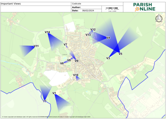
Appendix J – Justification for Important Views
|
ID |
Vantage Point & Direction |
Type |
Justification & Importance |
|
V1 |
From UCR 2 looking south east |
Mid distance view over countryside |
Popular view from Dark Lane across the Mimram valley and undulating countryside, capturing the rural essence of village surrounds. |
|
V2 |
From Ford looking along UCR2 looking north |
Framed view of Mimram stream |
Retain the view of a much-loved protected chalk stream, and ancient ford, appreciated by generations of villagers. The view towards Dark lane from the Mimram valley stream helps narrate the story of bygone village life. |
|
V3 |
From Footpath 8 looking north east to Ashley Grove |
Long distance view |
Traditional view framed by hedgerows and expansive local countryside, with footpaths leading towards an ancient grove, demonstrating a feeling of openness. |
|
V4 |
From Junction of Footpath 5 and 6 looking north-west to St Giles |
Wide view |
Much loved view of St Giles historic church nestled amongst a wooded backdrop, from open countryside. |
|
V5 |
From Footpath 5 looking north-west to St Giles photo |
Distant view |
Distant views to the village from a popular footpath, looking across rolling fields, heading towards St Giles Church and the north west of the village |
|
V6 |
From the bend on Heath Lane looking east |
Mid view |
A key view, from Heath Lane, looking along an approach towards the village centre, defined by flint walls, grass verges and hedgerows. |
|
V7 |
Entering Codicote village looking south-east along High Street |
Mid view |
Welcoming approach to the conservation area of the village through a part of the High Street verdant in character, showing the traditional flint walls to the right, and highlighting the villages rural nature. |
|
V8 |
From Heath Lane looking north-east to 1 & 3 Heath Lane |
Framed |
A view that reflects the historic character of the village with its many designated heritage and listed buildings, showing a 18th century building and the former village green to the right. |
|
V9 |
From Pond House looking north-west along High Street |
Mid distance |
View from the village green, with historic and heritage buildings either side of the high street. A classical village scene. |
|
V10 |
From St Albans Road looking southeast on Cowards Lane |
Framed |
Character view of a narrow village lane with verges and hedgerows. |
|
V11 |
From The Green looking west across Codicote |
Distant views |
Traditional view from the village across Codicote Heath, a well-used rural space traversed by public footpaths. |
|
V12 |
To St Giles Church across the churchyard |
Framed |
View of the medieval Grade II listed St Giles, with its stone and flint walls, utilised by communities through ten centuries, helping to narrate the story of bygone village life. |
|
V13 |
From St Giles Lychgate with war memorial, towards the church |
Framed |
This view of St Giles, its 15th century bell tower, and memorials to those that fell in the great wars. |
|
V14 |
From footpath 2 looking south east |
Mid distance |
Looking from the Whitwell Road grove, across the expanse of fields from a village footpath, with distant views. |
|
V15 |
From Bury Lane looking south west |
Mid distance |
Looking towards Codicote village and the sports centre with water tower in the background. View across The Great Field. |

Figure 43: View Map (Policies Map Extract)
