Ashwell Neighbourhood Plan Regulation 16 Submission
(1) 7 Natural environment
Natural landscape and rural character
7.1 The character of the village is influenced by the natural environment and draws on the traits of the local soils, aspect and geographic location. The village is positioned just beyond the eastern end of the Chiltern Hills, to the north of the Western Hills and west of Therfield Heath. It is underlain by Calcareous chalk, which produces alkaline soils with the potential for rare and uncommon chalk loving plant communities. This is a rolling landscape of high quality farmland, with large open fields and big skies.
7.2 Ashwell is typical of what Natural England considers as the East Anglian Chalk National Character Area (NCA No. 87):
"…the narrow continuation of the chalk ridge that runs south-west/north-east across southern England. The underlying geology is Upper Cretaceous Chalk, which is covered in a surface deposit of ice and river-deposited material laid down during the last ice age. This creates a visually simple and uninterrupted landscape of smooth, rolling chalkland hills with large regular fields enclosed by low hawthorn hedges, with few trees, straight roads and expansive views to the north."
7.3 Enclosure came late to the area and was never extensive. As a consequence, the landscape has few hedges, trees and woods, and the biodiversity of the land that surrounds the village is less diverse with fewer species. Hares and skylarks thrive and rare chalky plant communities, with species such as thyme and marjoram, can survive on unimproved, or semi-improved pasture and areas of lowland calcareous grassland. These are, however, rare habitats and there are a number of important surviving grassland habitats in the parish.
7.4 The wide open fields that characterise the outer parts of the parish play an important role in its character. The parish strides over the chalk scarp and views, especially of the church, can be seen from places like Partridge Hill, Station Road and Newnham Way. The views of the village from the main approaches need to be recognised and protected (See Figure 6.9 and map in Figure 6.10 ).
7.5 Natural England has prepared a number of Statements of Environmental Opportunity (SEO) for the East Anglian chalkland character area. These statements are designed to identify the important environmental functions of the landscapes and the ways in which the main characteristics of these areas can be balanced with landscape and land-use planning, community engagement and education, including the Local Plan making process. These are:
- SEO 1: Maintain sustainable, but productive, agricultural land use while expanding and connecting the chalkland assemblage of semi-natural grasslands, for example by sensitive management of road verges and extending buffer strips along field margins, to benefit soil and water quality, reduce soil erosion, strengthen landscape character and enhance biodiversity and pollinator networks.
- SEO 2: Conserve the regionally important East Anglian Chalk groundwater resource, by working in partnership to ensure that an integrated catchment-scale approach is secured for its enhanced long-term management, including the chalk streams, for the benefit of biodiversity, landscape character and recreational experience.
- SEO 3: Conserve and promote the landscape character, geodiversity, historic environment and historical assets of the chalklands, including the open views of undulating chalkland, large rectilinear field pattern and linear ditches, strong equine association and the Icknield Way prehistoric route. Improve opportunities to enhance people's enjoyment of the area while protecting levels of tranquillity.
- SEO 4: Conserve the settlement character and create or enhance sustainable urban drainage systems and green infrastructure within existing and new developments, particularly in relation to the urban fringe and growth areas such as south-east Cambridge, to provide recreation opportunities, increase soil and water quality and enhance landscape character.
However, this requires a carefully considered approach. Planting and management should maintain the land's existing character which is one of open fields, reflecting the limited impact of enclosure in the area (see para. 2.10).
Policy ASH10 Natural landscape and rural character
Summary
Full policy
POLICY ASH10 NATURAL LANDSCAPE AND RURAL CHARACTER
- Development proposals should maintain and enhance the natural environment, and retain landscape features, in accordance with Natural England's Statements of Environmental Opportunity (SEO) for the East Anglian chalkland character area and enhance the rural character and setting of Ashwell.
- Development proposals should demonstrate that they have addressed the following matters:
- respecting the natural topography of a site, preserving and sensitively incorporating existing natural features such as trees, hedgerows and ponds within the site; and
- being integrated into the landscape according to native ecological principles and including new landscape buffers between existing development and the countryside adjacent to development sites, particularly when seen from the village boundary; and
- ensuring adequate protection for trees and hedgerows during all phases of development to avoid damage, including activities causing soil compaction or severance of roots. Trees of arboreal significance should only be removed if diseased in which case they should be replaced with trees of a similar potential size and native species elsewhere on the site, unless this is clearly not possible.
- As appropriate to their scale, nature and location, proposals should provide open space that:
- Is in usable parcels of land and not fragmented; and
- Is safe, easily accessible and not severed by any physical barrier; and
- Is accessible to the general public; and
- creates a safe environment regarding lighting and layout; and
- is complemented by landscaping.
- Landscaping associated with construction and open space designs should be along ecological principles where possible using native species, (wildflower meadows), rain gardens (SuDS) and community orchards, to encourage species like bees and seed eating birds. Open spaces should provide an educational opportunity for people interested in the natural environment.
- Development proposals that provide for an appropriate legal agreement to ensure proper management of the open space over the lifetime of the development will be supported.
Conformity reference: NP Objectives: 8, 9; Saved Plan 1996: 14; Emerging Local Plan: SP12; NPPF (2019): 170 -171, 174 – 175; 177
Natural wildlife assets
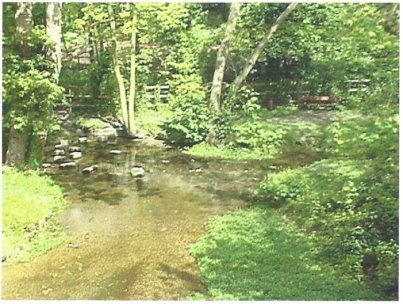
7.8 In terms of wildlife, Ashwell Springs, in the centre of the village, is a rare chalk stream wildlife habitat of 0.48 hectares. It has SSSI status and is managed by the Parish Council. The spring issues from the chalk to form one of the main sources of the River Rhee which flows into the River Cam and then into the Great Ouse. The water is at a constant temperature of around 100C. The cold temperature and clear water over gravel and chalk substrates are important for the survival of rare flatworms (Crenobia alpina and Polycelis felina), freshwater shrimps (Gammarus sp.) and fish such as Bullhead (Cottus gobio). The Springs are a valued and well visited local resource and village amenity with a natural paddling pool used for recreation.
7.9 Although not classed as 'main river' within the parish, the Rhee and its minor tributaries including Ashwell Quarry Springs and those at Westbury are all important chalk stream habitats and should be protected from damage caused by agricultural fertiliser and pesticide run-off or building development, with enhancement being a future aim wherever possible. Environment Agency guidance suggests providing buffer zones of 8m each side of water courses within which no development should be permitted.
|
|
|
Figure 7.1 Ashwell Springs |
7.10 Ashwell Quarry and Quarry Springs Nature Reserves are located west of the village. Although in private ownership, the former chalk quarry is leased to the Herts and Middlesex Wildlife Trust and managed by a local warden and volunteers. Possibly quarried from Roman times, the Totternhoe stone (a hard chalk rock) was used in Mediaeval times to repair St Mary's parish church. The poorer quality rock known as 'clunch' continued to be dug for use in local walls until the late 1800s but its main importance after the hard stone could no longer be extracted was as a source of lime for soil improvement, especially on the clay lands in the north of the parish. Extraction ceased in the early 1900s.
7.11 The chalky soil of the quarry now supports a wide range of flowering species such as Pyramidal Orchid (Anacamptis pyramidalis), Small Scabious (Scabiosa columbaria) and Clustered Bellflower (Campanula glomerata). The reserve also has important associated fauna such as the Chalkhill Blue butterfly (Lysandra coridon) and many species of small mammal including the rare Yellow-necked Mouse (Apodemus flavicollis). Nearby to the north is the clear spring, also part of the reserve. It feeds the River Rhee and is another important home to flat worms and other scarce wildlife.
7.12 St Mary's Church supports several species of bat including the uncommon Natterers Bat. Roosts and maternity colonies can be found in several other locations such as roof spaces and suitable trees with cavities. All bats are protected by law and any disturbance to roof spaces or the removal of old trees without the appropriate mitigation in place can have a serious impact on their populations..
7.13 A wide variety of bird species can still be found in the parish, although some are declining in numbers in common with other areas. Ashwell remains important in a county context for its farmland birds including skylarks, corn buntings and yellowhammers. Other small birds include summer breeding species such as blackcaps and whitethroats, swallows and swifts whilst common buzzards and red kites can be seen patrolling the area almost every day. Tawny, little and barn owls occur locally as do grey wagtails and mistle thrushes both of which are currently included on the Birds of Conservation Concern Red List.
7.14 The village supports a range of habitats comprising large and small gardens, allotments, orchards, small grass fields, hedges, walls, garden ponds and many trees both native and planted. Many of the longer-established field hedges contain fruiting trees such as cherry plum, crab apple and wild damson.
Wildlife corridors
7.15 Wildlife corridors are important features connecting wildlife populations otherwise separated by human activities. Hedges with botanically stable and diverse field margins, healthy rivers and streams, semi-natural and planted woodlands and tree belts are all wildlife corridors which are vital for allowing the movement of animals and the continuation of viable populations. Many such features occur in the parish but some are not as well-connected with other habitats or as sympathetically managed for wildlife as they could be.
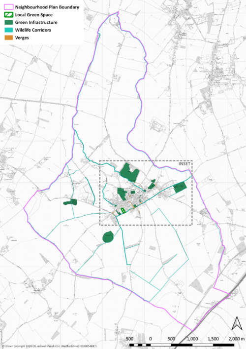
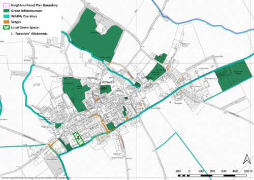
Figure 7.2 and Figure 7.3 show significant wildlife corridors within the parish. It illustrates the importance of watercourses and paths. All of the features mentioned above have a role to play though, and should be maintained so that wildlife can move freely and safely.
7.16 The proposed Environmental Land Management Scheme coming into operation following the end of the Common Agricultural Policy in the UK may encourage local landowners to take advantage of new initiatives to enhance and strengthen wildlife corridors throughout the ANP area. The ANP aims to prepare the ground for this sort of scheme.
Green infrastructure
7.17 Preceding paragraphs look at the Parish's natural assets from a wildlife perspective. 'Green Infrastructure' is a term that focuses on the contribution that these and other aspects of the environment make to the well-being of people living in the area and visitors alike. The human impact is what makes good quality green infrastructure important. Its two key characteristics are: that it is a network of integrated spaces and features, and that it is 'multi-functional', providing multiple benefits simultaneously. These can be to:
- Support people's mental and physical health.
- Encourage active travel.
- Cool urban areas during heat waves.
- Attract investment.
- Reduce water run-off during flash flooding.
- Provide carbon storage.
- Provide sustainable drainage.
7.18 ANP policy intends to exploit these multiple benefits. They are not just about providing critical spaces as wildlife refuges or stepping stones that prevent species becoming isolated, they are essential for health and well-being.
7.19 The extent to which green infrastructure provides these benefits depends on how it is designed and maintained, and the maturity and health of the elements that form it (such as trees). The green infrastructure assets of the Neighbourhood area – including gardens, fields, woodland, ponds - should be maximised and should facilitate the passage of wildlife. Development that provides accessible public space and improves the connectivity between wildlife areas and green spaces used by the community will be encouraged.
7.20 Development is also expected to play its part in enhancing biodiversity and the ANP accepts the need for an objective way of assessing this to enable real, measurable net biodiversity gain, as required by the NPPF.
At the time of writing the DEFRA and Natural England Biodiversity Metric 2.0[27] had just completed beta testing and, on its release in December 2020, would be the best available tool for assessing gain.
|
|
|
Figure 7.2 Network of the main green infrastructure elements in Ashwell Parish, including wildlife corridors |
PolicyASH11 Natural wildlife assets, wildlife corridors and green infrastructure
Summary
Full policy
(2) POLICY ASH11 Natural wildlife assets, wildlife corridors and green infrastructure
- As appropriate to their scale, nature and location development proposals are expected to demonstrate net biodiversity gain as calculated by the most up to date version of the DEFRA and Natural England biodiversity metric.
Proposals should also include provision for maintaining biodiversity gain in the future. - Proposals should be designed from inception to create, conserve, enhance and manage the network of green infrastructure – including the wildlife corridors shown on the policy maps, Figure 15.1 and Figure 15.2 - with the aim of delivering a net environmental benefit for local people and wildlife.
Proposals that seek to improve the connectivity between wildlife areas and green spaces will be supported in order to enhance the green infrastructure of Ashwell parish. In addition:- Future development should aim to include features such as swift and owl nesting boxes wherever appropriate; and
- New development should include fruiting trees in their planting mixes wherever possible.
- Watercourses in the parish should be left with a development-free 8 metre buffer zone on each side of the channel.
- Development will not normally be supported if it has an adverse effect on the Ashwell Springs Site of Special Scientific Interest unless it meets the NPPF criterion in para 175(b): "where the benefits of the development in the location proposed clearly outweigh both its likely impact on the features of the site that make it of special scientific interest, and any broader impacts on the national network of Sites of Special Scientific Interest".
Conformity Reference: NP Objectives: 9; Saved Plan 1996: 14; Emerging Local Plan: SP12; NPPF (2019): 170, 171; 175; 177
Local Green Spaces (LGS)
7.22 Under the NPPF, neighbourhood plans have the opportunity to designate Local Green Spaces which are of particular importance to the local community. This will afford protection from development other than in very special circumstances. Para 100 of the NPPF (2019) says that Local Green Spaces should only be designated:
- Where the green space is in reasonably close proximity to the community it serves.
- Where the green area is demonstrably special to a local community and holds a particular local significance, for example because of its beauty, historic significance, recreational value (including as a playing field), tranquillity or richness of its wildlife.
- Where the green area concerned is local in character and is not an extensive tract of land.
7.23 When designating Local Green Spaces, it is important to consider what protection is already afforded to an area and whether or not the designation will provide any further safeguard. Appendix D: Local Green Spaces, sets out a review of the green spaces in Ashwell to determine which might be appropriate for designation.
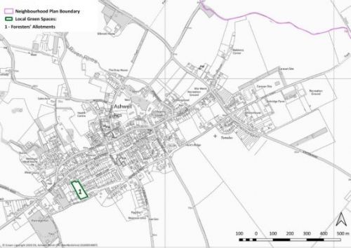
7.24 The review identified the Foresters' Allotments as an area of value to the community and in need of protection from inappropriate development. Figure 7.4 shows its location in the village. A more detailed map of this space appears in the 'Shortlisted Local Green Spaces' section of Appendix D, with an explanation of how it fulfils the Local Green Space criteria.
|
|
|
Figure 7.4 Local Green Space selected for registration: Foresters' Allotments (highlighted in green) |
Policy ASH12 Local green spaces
Summary
Full policy
(1) POLICY ASH12 Local Green Spaces
- The Ancient Order of Foresters' Allotments, as defined on the Policies Map, is designated as Local Green Space.
- Local policy for managing development on a Local Green Space should be consistent with policy for Green Belts (NPPF 145); proposals for built development will not be supported unless it can be clearly demonstrated that it is required to enhance the role and function of that Local Green Space.
Conformity reference: NP Objectives: 9; Saved Plan 1996: 14; Emerging Local Plan: SP12; NPPF (2019): 99 - 101, 145; 146