Ashwell Neighbourhood Plan Regulation 16 Submission
6 Design and heritage
Character of development
6.1 Throughout the engagement on the ANP, the community has stressed that new development should reflect the character of the parish and that the design of development should look and feel like local properties. The ANP requires high-quality design standards that integrate with the area and reflect and reinforce, without overwhelming, the rural character of the parish.
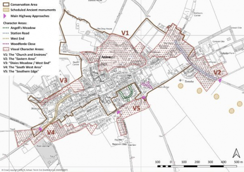
6.2 NHDC published a Design Supplementary Planning document in 2011[5], which describes Ashwell as a large village set in open countryside in the north of the district at the foot of the scarp slope of the chalk ridge. Alongside the Conservation Area, which covers much of the village, it identifies distinct character areas, such as West End, Station Road, Angell's Meadow and Woodforde Close. In addition, it identifies five Visual Character Areas:
- V1: The "Church and Environs" preserves the open nature of the church and surrounding farmsteads and meadows to the North of the village.
- V2: The "Eastern Area" protects the ribbon development east of the recreation area and treats it as part of the countryside.
- V3: "Dixies Meadow / West End" protects farmstead buildings and extensive views of the countryside fields.
- V4: The "South West Area" protects against further extension of the village in this area, which would appear to be visually sensitive and located on rising ground.
- V5: The "Southern Edge" protects the low density, ribbon development from further consolidation.
When complete, a new version of the Design Supplementary Planning Document and the NHDC's Local Plan 2011-2031 are likely to replace this document. However they are not expected to alter materially its conclusions or recommendations.
6.3 NHDC has also issued an Ashwell Conservation Area Character Statement[6] that describes what makes the area special and identifies key assets and views within it. In response, The ANP recognises that these require special consideration when any development or change is proposed.
6.4 Figure 6.1 shows the Conservation and Character Areas in Ashwell village.
6.5 The Ashwell Village Design Statement[7] 2000 set out additional detail about the character of the village and the parameters that should be considered for development. The document was revised in 2018 and a copy of this revision is in Appendix E. Both describe the built character across the parish as ranging in style, age, size and housing densities. For each area to maintain its character, a balance needs to be struck between the scale, bulk, density and height of the built form and that of open green spaces and, where relevant, the countryside.
6.6 All development should be designed to a high quality and reinforce and enhance local character, heritage assets and the rural setting of the area. The density of development should create a character that is appropriate to the site's context, including the landscape in which it is set, whilst making best use of the land available. Lower density housing should be located towards the outer edges of the settlement where it abuts open countryside, to maintain views from and into the individual settlements.
6.7 Development should have regard to both the character of the area in which it is set and to the character of the area overall.
Policy ASH3 Character of development
Summary
6.8 A large part of Ashwell village lies inside a Conservation Area and it has five Local Character Areas. Development must preserve and complement the features that make this place special. Subject to that, innovative design[8] will be supported where it clearly enhances its surroundings.
Full policy
(2) POLICY ASH3 CHARACTER OF DEVELOPMENT
- Development should conserve and enhance the Conservation Area, the Character Areas V1 to V5 as shown in Figure 6.1 , and key views and assets identified in the Conservation Area Character Statement 2019.
- The design of new development should demonstrate how it has taken account of the local context and reflected the character and vernacular of the area, using architectural variety in form and materials, in order to avoid building design that is inappropriate to the ANP area. For example: clusters of large, similar houses (in excess of three bedrooms) are not a characteristic of the village.
However, innovation in design will be supported where this demonstrably enhances the quality of the built form in a character area. - As appropriate to their scale, nature and location, development proposals should address the following criteria:
- make a positive contribution to the visual impact of the village from the highway and footpath approaches; and
- not have a significantly detrimental impact on the local views as set out in POLICY ASH9 Locally significant views.
- Development proposals affecting designated and non-designated heritage assets (either directly or via a change in their settings), will be expected to respect, conserve and enhance the significance of those assets.
Conformity reference: NP Objectives: 8; Saved Plan 1996: 7; Emerging Local Plan: SP8, SP9, SP13; NPPF (2019): 125, 127
Design of development
6.9 Good quality housing design can improve social wellbeing and the quality of life by improving the built environment, reducing crime, improving public health, easing transport problems and enabling greater access to green space.
6.10 In October 2019, a new National Design Guide[9] was launched, forming part of the Government's collection of Planning Practice Guidance. It forms a material consideration in the decision-making process, particularly in the absence of local design guidance. The document sets out the ten characteristics necessary for creating a well-designed place, contributing to its physical character, a sense of community and addressing environmental issues affecting climate.
6.11 The guide Building for a Healthy Life, 2020[10] is the Government-endorsed industry standard for the design of new housing developments. Building for a Healthy Life is a tool for assessing the design quality of homes and neighbourhoods. Its criteria also link to other standards for housing design, including the Housing Quality Indicators[11] (HQI) standards and Secured by Design[12]. It provides a framework that stakeholders should use for development along with other policies contained within this plan for the neighbourhood area to achieve the industry standard's 'Built for Life' quality mark.
6.12 When these building standards and design guides are updated or superseded, the ANP should apply the updated standards for good quality, well-designed homes and neighbourhoods.
6.13 The Ashwell Village Design Statement 2000, as amended in 2018, (see Appendix E), elements of which were adopted as Supplementary Planning Guidance (SPG) by NHDC in 2000, includes general design guidelines for the village as well as guidelines that are specific to the Character Areas (as described in 6.2). In August 2018 the ANP Working Group revised sections of the Design Statement relating to the settlement pattern (6) and buildings (7) for the purposes of the ANP.
Applicants should work closely with those affected by their proposals to evolve designs that take account of the views of the community. It is expected that the entirety of the guidance contained in the revised Design Statement is adhered to, not only that which has been adopted as SPG.
6.14 The Housing Survey 2015 undertaken for the ANP revealed a series of further points felt to be important to incorporate into any future housing design:
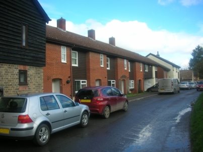
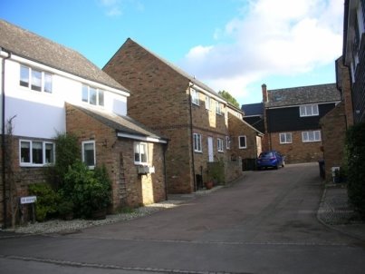
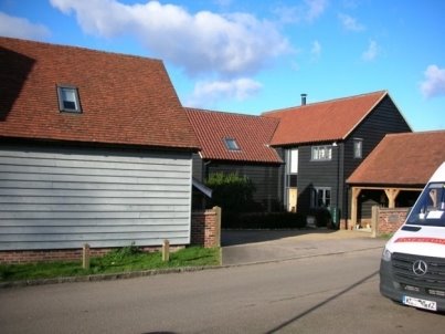
- Small clusters of housing: The positioning and layout of houses is an important contributory factor to overall good design. Small, informally laid out clusters of dwellings give a feeling of space, compared with repetitive layouts of larger numbers of dwellings often observed in 'dense' developments.
The pictures below show housing layouts in Ashwell that the community cited as good examples.
|
|
|
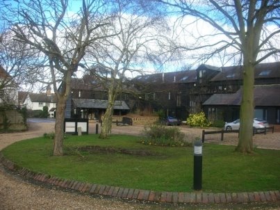
Figure 6.2 The Bear Farm housing development and the scale of the houses themselves reflect the character of their surroundings, in this case in a high density part of the village characterised by short terraces containing small numbers of dwellings (Bear Lane/Back Street) |
|
|
|
Figure 6.3 The Rickyard is a courtyard style and not a sprawling Close-style development. It is in keeping with its surroundings yet still provides adequate parking spaces |
|
|
|
Figure 6.4 Whitby Farm is another courtyard style development: another moderately sized cluster that reflects its origins (i.e. it was a farm) and is well integrated into the pattern of the village |
Of those responding to the Community survey, 47% considered bringing dwellings back into use by renovation and developments of up to ten dwellings acceptable. The proportion fell to 8% for up to twenty dwellings, an understandable response since, as a single development, that alone would represent growth of 2.3% in a well-established and historic village.
Whilst sites of fewer than 11 units would not be obliged to provide any affordable housing within the NPPF definition, they will be expected to meet local housing needs as will be required in Policy HS3 in the Emerging Local Plan and in the ANP POLICY ASH2 Housing mix, with the aim to ensure the sustainability of the village and give the opportunity for younger single people and families to remain in the village.
The ANP would also strongly encourage offers from developers prepared to provide affordable accommodation in excess of the levels stipulated in the Emerging Local Plan.
- Mixed and integrated: Development should follow the traditional street pattern with a variety of housing types that are closely integrated with community services and businesses. There should be an emphasis on safe access on foot and connectivity with the village centre without using a vehicle. This should apply to all ages, especially families with young children, older residents and those with restricted mobility.
|
|
|
Figure 6.5 The development also reflects is past use as a farmhouse and outbuildings in style and layout and seamlessly integrates business premises and residential units. It is well connected with the rest of the village and can be accessed from two sides of the site (Dixies Barn) |
- Appropriate density: New units should not be automatically "crammed together", but reflect densities in the immediate neighbourhood, though in parts of the village centre it is fairly high. This is consistent with the Emerging Local Plan's requirement in policy HS3 that "the scheme would provide a density, scale and character of development appropriate to its location and surroundings." and in para 8.21 which states, "Development on the periphery of settlements should generally be at a lower density to mark the transition to the rural area beyond."
|
|
|
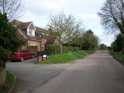
Figure 6.6 As development approaches the settlement boundary the housing density falls considerably (Ashwell Street/ Moules Yard) |
- Infill or development of vacant / brownfield sites: This acceptable as long as the density for that site does not exceed that of neighbouring plots and also contributes to a significant fall in building density with increasing distance from the centre of Ashwell village.
6.15 To a great extent, the points above reflect concerns about the sustainability of development that the ANP intends to manage with all its policies.
Policy ASH4 Design of development
Summary
Full policy
(2) POLICY ASH4 Design of Development
- Development will be supported where it demonstrates a high quality of design, which responds and integrates well with its surroundings, and meets the changing needs of residents. It should also minimise its impact on the natural and historic environment, respecting the topography and the issues that it may create with, for example, access and open views.
Development proposals should demonstrate how they have sought to address the following matters:- being guided by the National Design Guide and the principles of Building for a Healthy Life unless alternative principles would otherwise result in a higher quality of design. Development proposals will be supported where they achieve the relevant quality mark; and
- dwellings designed to be suitable for older residents (aged 60 and over) - particularly bungalows. Such dwellings should also be suitable for younger residents and are not intended to be restricted in use; and
- adherence to the space and access standards in Technical Housing Standards[13] and Building Regulations (Part M)[14] and the Hertfordshire Sustainable Design Toolkit[15]; and
- the guidance contained within the Ashwell Village Design Statement 2000, as amended in 2018 (Appendix E of the ANP); and
- the creation of variety through the use of a range of housing designs, provided that the predominant type of design reflects the character of the area; and
- to design layouts of safe and secure dwellings that meet the requirements of 'Secured by Design' and minimise the likelihood and fear of crime; and
- provide off-road parking for residents, visitors and service vehicles, in accordance with NHDC's Car Parking Standards[16] or their successor in either Appendix 4 of the Emerging Local Plan[17] (once adopted), or for non-residential building, the New Development Supplementary Planning Document September 2011[18]; and
- traffic generation and parking does not adversely affect vehicular and pedestrian safety; and
- ensure that areas requiring service and maintenance, including watercourses, are accessible at all times.
Conformity reference: NP Objectives: 1, 10; Saved Plan 1996: 21, 28, 55, 57; Emerging Local Plan: SP8, SP13; NPPF (2019): 124, 126, 127, 149
Flood risk
6.17 Surface water flooding is an issue for the village, principally around the western part of the High Street and in West End, though other parts of the High Street, Back Street, Bear Lane, Church Lane and Hodwell have also been affected. The Environment Agency's flood map (see Figure 6.7 and Figure 6.8 ) highlights this risk and the Agency has advised the inclusion of a policy in the ANP to help manage it. Note that the flooding related maps are periodically updated by the Environment Agency and the most up-to-date mapping should be used[19].
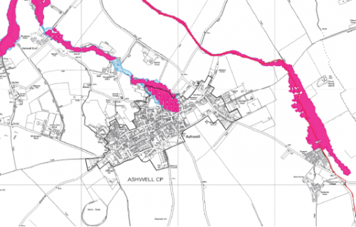
The Environment Agency has also highlighted in its comments that the village settlement boundary extends into flood zones 2 and 3, as identified in North Hertfordshire District Council's Strategic Flood Risk Assessment (2008).
|
|
|
|
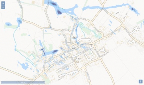

Figure 6.7 Surface water flood risk map of Ashwell village (Source: Environment Agency)
|
|
|
Figure 6.8 Ashwell flood zones 2 (blue) and 3 (pink) (Source: North Hertfordshire District Council SFRA 2008) |
6.18 There is serious concern about run-off from the scarp face that lies to the south of the village. This is a problem because not only has it created flash flooding but it also silts up drains, making the impact worse. In 2011 the Department for Food, the Environment and Rural Affairs (DEFRA) established Sustainable Drainage Systems (SuDS) standards to manage run-off volumes and flow rates from hard surfaces in a sustainable way, reducing the impact of development. They were updated in March 2015[20].
The ANP expects proposals for development within the village settlement boundary to comply with the standards.
6.19 To ensure that flooding and drainage matters are not made worse in the future, it is essential that any new development fully takes into account its possible impact on flooding and drainage not only within the site itself but its off-site effects within the village and surrounding areas. Whilst flooding issues are generally dealt with at the strategic level, the ANP presents an opportunity to encourage effective solutions that can add additional capacity and flexibility to water drainage systems in cost effective ways.
Policy ASH5 Flood risk
Summary
Full policy
(2) POLICY ASH5 Flood risk
- Site development should use Sustainable Drainage Systems (SuDS). Such systems should comply with "Sustainable Drainage Systems Non-statutory technical standards for sustainable drainage systems" March 2015 (or any that replace them) and the relevant NPPF and Planning Practice Guidance to which it refers.
Such development should demonstrate the use of a wide range of creative SuDS solutions, for example through the provision of SuDS as part of green spaces, green roofs, permeable surfaces and rain gardens. Only where it is demonstrably unfeasible will an absence of any on-site SuDS provision be supported in such developments.
If a non-SuDS solution is justified it must nonetheless perform at least as well as a design complying with SuDS (or replacement standards). - SuDS provision must demonstrate how its design will enhance wildlife and biodiversity as well as minimise the impacts of flooding, including fluvial.
- All developments are expected to comply with the drainage authority's (currently Anglian Water, as at January 2020) current Surface Water Drainage policy[21].
- Major development proposals (i.e. 10 dwellings or more) should be supported by a drainage scheme maintenance plan which demonstrates a schedule of activities, access points, outfalls and any biodiversity considerations. The maintenance plan should also include an indication of the adopting or maintaining authority or organisation and may require inclusion within a register of drainage features.
Conformity reference: NP Objectives: 1, 9, 10; Emerging Local Plan: SP11(b), D1(b)(ii), NE7, NE8; NPPF (2019): 20, 34, 148-150, 155-165
Sustainable water supply
6.21 Ashwell Springs SSSI (which forms the source of the River Rhee) is an environmental asset, being a chalk water spring with a unique habitat of flora and fauna.
Chalk streams are particularly vulnerable to drier weather. Only 200 are known globally, 85% of which are found in the UK in southern and eastern England. These streams emerge from the chalk aquifer, so the very pure water is rich in minerals and remains at a fairly constant temperature year-round. This good water quality supports many invertebrate and fish species making them an important haven for wildlife. They are also highly valued culturally.
6.22 The Environment Agency is taking action to protect chalk streams by reducing the amount of water abstracted. Water is taken from rivers primarily by the water sector, the energy sector, and for use by industry and agriculture. Any of these abstractions over 20 cubic metres per day require a licence from the Environment Agency.
6.23 Ashwell Springs is protected within Affinity Water's Drought Management Plan[22] because it is imperative that water resources are managed sustainably. When consulted, the Environment Agency confirmed this view and recommended the inclusion of a policy to protect Ashwell Springs SSSI and chalk streams. For this reason all new homes should achieve total mains water consumption of no more than 110 litres per person per day. This target is equivalent to that proposed, when the need arises, in para. 14 of the Housing: optional technical standards 2015[23].
Policy ASH6 Sustainable water supply
Summary
Full policy
POLICY ASH6 Sustainable water supply
- All residential development proposals will be required to achieve the water consumption standard set out below unless it can be demonstrated that doing so is not technically feasible or would make the scheme unviable.
Residential: total mains consumption of no more than 110 litres per person per day. - All major development proposals should be approved by the water supplier (Affinity Water, as at January 2020) in respect that they would not threaten the current achievement of minimum acceptable flow rates at Ashwell Springs and feeder chalk streams as committed within Affinity Water's Drought Management Plan.
Conformity reference: NP Objectives: 1, 9; Emerging Local Plan: SP11(c), D1(d), NE10(a), NE10(b); NPPF (2019): 20, 34, 149
Environmentally sustainable design
6.25 On 12 June 2019 the Government voted to amend the Climate Change Act 2008 by introducing a new target to reduce greenhouse gas emissions in the UK to zero by 2050 (known as a 'net zero' target). This is a challenge that will require everyone to be engaged: from households and communities, to businesses and local and national government.
6.26 Being 2050 ready will require new build to have minimal energy use and net carbon emissions over the year. They should be highly insulated, have low water demand and be fitted with or directly connected to renewable energy systems.
6.27 Notwithstanding current building regulations, standards for ecologically sustainable homes and developments are optional, but planners and developers are strongly encouraged to make use of energy efficient, sustainable materials and to consider high-efficiency alternative systems and facilities for development sites. In this context, the orientation of buildings can be important in order to make best use of available sunlight.
6.28 The Code for Sustainable Homes was withdrawn by the Government in 2015 and this has been replaced by new national technical standards which include new additional optional building regulations regarding water and access as well as a new national space standard (this is in addition to the existing mandatory building regulations). In addition, the 'Building Research Establishment Environmental Assessment Method' BREEAM is a widely recognised, accredited, independent method for assessing environmental performance of non-residential buildings. Until superseded by nationally prescribed standards, the BREEAM standards for non-residential and multi-residential buildings by nationally recognised certification bodies may also be accepted.
6.29 There is an opportunity to improve and promote sustainability in Ashwell by:
- Following basic passive environmental design in a 'fabric first'[24] approach.
- Integrating renewable energy systems into new development, including existing and new public buildings.
- Reducing water consumption through grey water systems.
- Promoting sustainable forms of transport through priority systems for pedestrians and cyclists.
- Community energy schemes.
- Promoting public transport.
6.30 The ANP seeks to encourage energy efficient and sustainable well-designed development.
Policy ASH7 Environmentally sustainable design
Summary
Full policy
(1) POLICY ASH7 ENVIRONMENTALLY SUSTAINABLE DESIGN
- Development proposals which seek to maximise design principles for energy efficiency and sustainability will be supported, in order to reduce energy consumption and climate effects. Proposals which incorporate the following energy design principles as appropriate to their scale and nature will be particularly supported:
- the principles established in the Hertfordshire Sustainable Design Toolkit, including updates; and
- the achievement of a fully integrated energy efficiency design which will achieve an EPC rating of 'A'; and
- siting and orientation of buildings to optimise passive solar gain; and
- the use of high quality, thermally efficient building materials; and
- the use of low carbon and renewable energy sources consistent with achieving sustainability and an EPC 'A' rating; and
- reducing water consumption through the use of grey water systems; and
- non-residential developments should aim to meet the Buildings Research Establishments BREEAM building standard 'excellent'.
- Alterations to existing buildings (where planning permission is required), including the sensitive retrofitting of historic buildings, should be designed with energy reduction in mind and comply with current sustainable design and construction standards.
Conformity reference: NP Objectives: 10; Saved Plan 1996: 21, 57; Emerging Local Plan: SP11, D1, D4; NPPF (2019): 149, 150(b), 151
Protecting historic assets
6.32 Ashwell has 78 listed building of which one, St Mary's Church, is listed Grade I, eight are Grade II* and 69 are Grade II. There are seven scheduled monuments in the Parish, including Arbury Banks, and numerous assets of local historic interest. The historic core of Ashwell was first designated a Conservation Area in 1968, the boundary being revised in 1978 and again in 1986.
Appendix B provides a full list of the nationally listed sites.
6.33 The best way to ensure heritage is protected is through good design, in particular with regard to build scale, form, massing, setback and materials. There is already legislation, borne out in national and local planning policies, which seeks to protect the character of listed buildings from inappropriate development.
6.34 The village, however, has several non-designated heritage assets that are considered to make an important contribution to the distinctive local character of the parish. Details of these assets is contained in the document, 'Ashwell Buildings and Antiquities', the 2nd Edition of which was published in 2020 and which is contained in Appendix C. This is the culmination of a project undertaken by a working party that was set up by the Parish Council in response to a request from the District Council to recommend revisions to the list of Listed Buildings which was originally prepared by the former Ministry of Housing and Local Government in the 1950s.
6.35 POLICY ASH8 extends protection to non-listed heritage assets of local importance. It seeks to protect them from detrimental impacts of development. There will be a strong presumption against the loss of those structures appearing in the associated document and developments which result in this will be refused.
6.36 In parallel with this policy, the Parish Council proposes that these buildings and structures are considered by North Herts District Council for inclusion in a Local List. There are precedents for this: lists already exist for Letchworth, Hitchin, Baldock, Newnham, Knebworth and Royston. However, the inclusion of any building or structure on a Local List is not necessary for the application of this policy. Note that the policy does not confer listed building status (a national designation) on any non-designated heritage assets. Works to buildings and structures listed in Appendix C will not require listed building consent.
6.37 There are currently three assets on Historic England's 'The Heritage at Risk Register': Church of St Mary, Roman Villa northeast of Ashwell village (archaeological site) and Town House (Ashwell Museum). An associated action in the ANP will be for the Parish Council to work with Historic England and NHDC to monitor heritage assets and to devise a strategy for bringing them back to their former glory.
Policy ASH8 Protecting historic assets
Summary
Full policy
(2) POLICY ASH8 Protecting Historic Assets
- New development should seek to avoid harm to the heritage assets (designated and non-designated) within the ANP area.
- Development proposals that conserve or enhance the historic environment will be supported. Proposals that could affect the significance of the buildings or structures of character as set out in Appendix C of the ANP will be supported if they preserve, sustain and enhance the special character, significance, appearance and locally distinctive features of the asset/s affected, particularly in terms of scale, form, proportion, design, materials and the retention of features.
- Planning permission will not normally be granted for development that would result in the loss of these assets and will only be supported where it can be demonstrated that the benefits of the scheme outweigh the scale of any harm or loss, having regard to their significance.
Conformity reference: NP Objectives: 8; Saved Plan 1996: 16; Emerging Local Plan: SP13, HE1, HE2, HE3; NPPF (2019): 189, 190, 192 - 197
Locally significant views
6.39 With a well-established population, views contribute to tradition, memory and sense of place. They are equally important for residents and for visitors. The Ashwell Village Design Statement 2000, as amended in 2018, (Appendix E) includes a reference to the importance of views, noting that "important vistas must be protected, particularly those which allow views of the countryside from within the village."
6.40 In addition to views out from within the village, there are many views towards the village, or within the village itself, which are intrinsic to Ashwell's sense of place. Many of these views focus on the tower of St Mary's Church, a grade I listed medieval building. Indeed, In 'The Spectator' of July 1956 Sir John Betjeman[25] comments on Ashwell's church thus:
"So I went to Ashwell. We first saw its gigantic fourteenth century church tower... dominating all, this magnificent church tower. And the church inside, white and spacious and East Anglian, with arcades like a Cathedral, clear glass everywhere, uneven floors and splendid chancel, was worthy of the best of English villages."
It should be noted that while some views or vistas are experienced from a single viewpoint, there is often a dynamic component to many views that changes and evolves as one moves along a street or path. It should also be noted that some views may be more apparent in winter when the leaves are off the trees. New developments should explore opportunities to create new views or vistas.
6.42 This policy seeks to ensure that adequate weight is given to the conservation and enhancement of views significant for local people and visitors.
|
Ref |
Description of the view |
Photograph |
|
SV1 |
To the South West – from Cow Lane - St. Mary`s Church with well-maintained field hedge in the foreground. Cow Lane is a historically significant access route to the village and the Church from the Mordens. This open countryside approach provides a clear view of the Church and a valued visual transition from countryside landscape to the village's structures. |
|
|
SV2 |
To the South West - Mill Street. An archetypal English village scene showcasing listed buildings, with the mill in the foreground and St. Mary`s behind, set among the many mature trees. |
|
|
SV3 |
To the South East - from ground off Rollys Lane, purchased by the Merchant Taylors Company with funds from Henry Colbron's bequest. St. Mary`s Church with rear of Merchant Taylors in the foreground. This view of St Mary's is seen within the heart of the historical centre of the village and is sensitive to roof heights to avoid obscuring the church. |
|
|
SV4 |
To the South – from Coldharbour Lane. This view provides context for the Ashwell settlement which nestles in the valley to the north of Slip End and Claybush Hill which is visible in the distance with open countryside in both foreground and background. |
|
|
SV5 |
To the East – from Gardiners Lane. Fine view of St. Marys Church through Bushel and Strike car park. Another view of the church from within the heart of the historical centre of the village which would be sensitive to being obscured by additional buildings. |
|
|
SV6 |
To the North East and also to the North (not pictured)– from the High Street. St Mary's Church tower viewed across Dixies Meadow, the only green space, bordering High Street, and close to the village centre. It is the combination of a green space and a view of the church's position in the village directly visible from the main road which makes this piece of land sensitive to development. |
|
|
SV7 |
To the North East – from West End. A more distant view of St. Mary's Church. This is an iconic main route into the heart of historical Ashwell with a variety of housing styles and ages built right up to the pavements, including nationally listed buildings.. |
|
|
SV8 |
To the North – from High Street and Church Lane. St Mary's Church with densely sited historic housing bordering the narrow Church Lane in the foreground. This view forms part of the important central area of the village and would be highly sensitive to development. |
|
|
SV9 |
To the East – from Newnham Hill. This view is from a path popular with walkers. The picture shows how well the village is contained by good greenery. It is a classic view of open countryside, punctuated by the Grade I listed St Marys church |
|
|
SV10 |
To the North – from Claybush Road Significant view of St Mary's Church tower as a village focal point from open countryside bordering Claybush Road which is the main access route from the South. |
|
|
SV11 |
To the North – from Claybush Road St Mary's Church tower clearly visible from high ground. For road users this is a striking introduction to the village, and this southern edge's sensitivity to development is mentioned in the Landscape Character Area Assessment 224. |
|
|
SV12 |
To the North – from Ashwell St (also known as The Ruddery). An important distant view through Hunts Close pasture land across Lucas Lane housing and beyond to open countryside in the North towards Wrestlingworth. The view projects a strong feeling of space and rural tranquillity. |
|
|
SV13 |
To the West – from the corner of Station Road and Lucas Lane. The grade II listed memorial by Lutyens is a commanding presence here. The recreation ground, playground and pavilion provide a setting for traditional village green sport and children's play. Within the village Settlement Boundary it is the largest green open space and has historical significance as a recreation area. It also provides a visual transition from built forms to countryside at the North East corner of the village. |
|
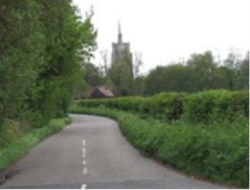
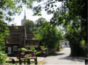
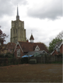
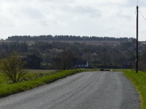
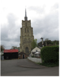
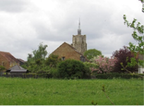
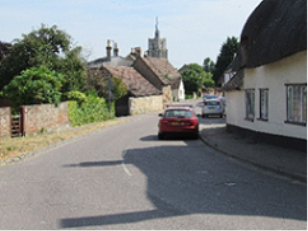
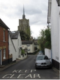
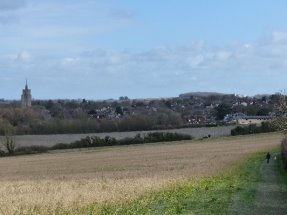
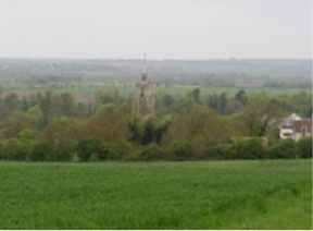
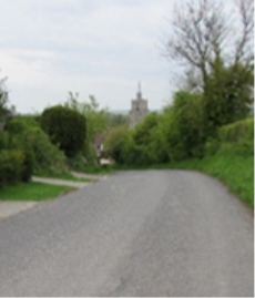
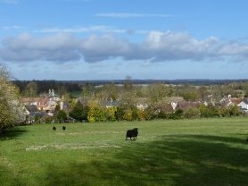

Figure 6.9 important views, with descriptions and an indication of their significance
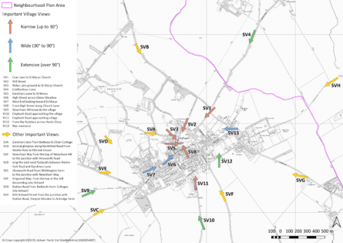
6.43 The map in Figure 6.10 shows the location of the views and their orientation. It includes dynamic views ('Other important views') referred to in paragraph 6.41 but not illustrated in Figure 6.9
|
|
|
Figure 6.10 map showing locally significant views |
Preserving the character of the village landscape
6.44 Maintaining the visual character in and around the village was identified as an important aim in the NHDC commissioned Landscape Character Area Assessment 224[26], which it adopted in 2005, and updated in 2011. Its purpose was to:
- Advise on development control matters for both NHDC and Stevenage Borough Council.
- Develop policy for future development plans.
- Provide a framework for other landscape planning.
- Inform countryside conservation and management activities, access and recreation projects.
- Support grant applications.
6.45 To achieve its purpose the report identified a number of features of the North Baldock Chalk Uplands in and around Ashwell that need preserving and/or enhancing. The ANP acknowledges this need, noting the following comment about the village's built form:
"There are many fine traditional buildings particularly in and around the nucleated settlement of Ashwell. This village has more architecturally worthwhile houses than many others in the county. Nearly all are timber framed or gabled brick type and some are of medieval origin."
6.46 The Assessment found that the setting of these structures and the local views are important to the preservation of their character as well as the settings and views being important in themselves, commenting that:
- In visual terms North Baldock Chalk Uplands is considered to be of moderate to high sensitivity. Open views and skylines throughout the Character Area are particularly sensitive to development.
- The southern edge of Ashwell is self contained and would be sensitive to further development.
- St Mary's Church in Ashwell forms a landmark feature in many views within the Character Area.
6.47 Built development guidelines were to:
- "Retain the rural character of the Character Area ensuring that any new development is appropriately sited and of a scale, form and style appropriate to the Character Area."
- "Conserve the traditional character of Ashwell, particularly the approaches to the village from the south and west. Ensuring that any development within or located on the edge of the village uses appropriate vernacular materials and features."
Policy ASH9 Locally significant views
Summary
Full policy
(2) POLICY ASH9 Locally significant views
- The Plan identifies twenty one locally-significant views, described and mapped in Figures 6.9 and 6.10. As appropriate to their scale and nature, development proposals within the arcs of the various views as shown on Figure 6.10 should be designed in a way that safeguards the locally-significant view or views concerned.
- Development proposals are required to ensure that they do not have a significantly detrimental impact on the locally significant views shown in Figure 6.9 and mapped in Figure 6.10 and the policy maps, Figure 15.1 and Figure 15.2
- Development proposals are to comply with the findings and guidelines in Character Area Assessment 224 referred to in paras 6.44 to 6.47 of the ANP.
Conformity reference: NP Objectives: 8; Saved Plan 1996: 21; Emerging Local Plan: NE1, HE1; NPPF (2019): 124, 125, 127; 170(a); 170(b); 171
[6] https://www.north-herts.gov.uk/sites/northherts-cms/files/Ashwell%20Conservation%20Area%20Character%20Statement.pdf (27/12)
[7] https://www.north-herts.gov.uk/sites/northherts-cms/files/files/spg18_ashwell_village_design_statement_oct_2000-2.pdf (27/12)
[8] What is considered 'innovative' would depend on the circumstances of the case and cannot be defined exactly to suit all cases. However, as an example, it could be taken to mean new materials, methods or approaches that improve on conventional solutions, or the beneficial adoption of existing materials, methods or approaches not normally used in the situation under consideration.
[12] https://www.securedbydesign.com/ (27/12)
[13] https://www.gov.uk/government/publications/technical-housing-standards-nationally-described-space-standard (27/12)
[14] https://www.planningportal.co.uk/info/200135/approved_documents/80/part_m_-_access_to_and_use_of_buildings (27/12)
[15] https://www.hertfordshire.gov.uk/microsites/building-futures/a-sustainable-design-toolkit/sustainable-design-toolkit.aspx#:~:text=The%20Sustainable%20Design%20Toolkit%20aids,stages%20for%20development%20in%20Hertfordshire. (27/12)
[16] https://www.north-herts.gov.uk/planning/planning-policy/local-plan-current-policy/district-local-plan-no2-alterations/saved-local Policy 55 (27/12)
[17] https://www.north-herts.gov.uk/sites/northherts-cms/files/Proposed%20Submission%20Local%20Plan.pdf (27/12)
[18] https://www.north-herts.gov.uk/sites/northherts-cms/files/files/vehicle_parking_at_new_development_spd_sept_2011.pdf, Section 5 (27/12)
[19] https://flood-warning-information.service.gov.uk/long-term-flood-risk/map, surface water (27/12)
[20] https://assets.publishing.service.gov.uk/government/uploads/system/uploads/attachment_data/file/415773/sustainable-drainage-technical-standards.pdf (27/12)
[21] https://www.anglianwater.co.uk/developers/drainage-services/sustainable-drainage-systems/surface-water-policy/ (27/12)
[23] https://www.gov.uk/guidance/housing-optional-technical-standards#introduction, derived from 2015 Approved Document G, Building Regulations 'Sanitation, hot water safety and water efficiency', March 2015, pp.15 G2(3) (27/12)
[24] A 'fabric first' approach to building design involves maximising the performance of the components and materials that make up the building fabric itself, before considering the use of mechanical or electrical building services systems
[25] http://archive.spectator.co.uk/article/13th-july-1956/12/city-and-suburban (subscription) (27/12)