Ashwell Neighbourhood Plan Regulation 16 Submission
(2) 2 Local context
A brief history of Ashwell
2.1 The village of Ashwell lies at the centre of a large parish of over 1,800 hectares (4,000 acres). The parish is the most northerly in Hertfordshire and borders both Bedfordshire and Cambridgeshire. The settlement we know today lies to the north-west of a shallow chalk escarpment, near springs surrounded by ash trees from which the village derives its name.
2.2 A Neolithic (c.2,700 to 2,000 BC) henge was discovered in a field south of Ashwell Street and close to the village in 2015. It may have been related to the Springs and might have had a religious function. There are numerous Bronze Age (c.2,000 to c.800 BC) barrows in the area such as Highly Hill and the site of the Neolithic henge. Arbury Banks is an Iron Age (c.800 BC to c.100 AD) hillfort which was probably used only when an attack was imminent or underway. The Iron Age settlement was probably in the area of Buttway Cottages, i.e. to the west of the road going from the village to Ashwell End.
2.3 Roman material found in 2002 at Ashwell End indicates that there had been a religious site there in honour of Senuna, a goddess not found anywhere else in the Roman Empire. Near a site of religious pilgrimages such as this, there would have been places to satisfy the needs of visiting pilgrims although, to date, nothing has been found. There was a villa in a neighbouring field. There was also a villa on the south facing side of Partridge Hill and aerial photographs show Roman fields not far from it.
2.4 To the north of Ashwell Street in Hunts Close archaeological excavations have found items from Roman, Saxon and Medieval periods such as coins, pottery items, a bow brooch, an elaborately decorated copper alloy sword scabbard chape, and a decorated silver gilt handle from a Romano-British priest's ritual rattle. It is probable that this was a Roman religious site as well.
2.5 A three-field system of agriculture was probably in existence in the southern part of the parish in the late ninth century or early tenth century but could have been much older. The northern, low-lying and flatter part of the parish had mixed use. The section closest to the present village, which is intersected by the River Rhee, was probably pasture. The land further north, bounded by the Rhee and its tributary the Ruddery, seems to have been mainly pasture and woodland, with a section on the eastern side being meadow. Most of this land was slowly incorporated into the arable three field system in the early medieval period.
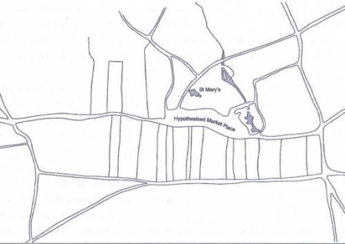
2.6 The village of Ashwell dates from the early tenth century (c. 917) when the framework of the present road structure was laid out (see Fig 2.1). The Anglo-Saxon new town, as it was then, was formed around a large marketplace which stretched from the Springs to Gardiners Lane, with one boundary on High Street and another on a combination of Swan Street, Hodwell and the path from the Lock-up to the Springs. The area close to the church and enclosed by the present day roads of Swan Street, Church Lane, High Street and Gardiners Lane, would have been the market for goods. The area from Church Lane to the Lock-up and beyond to the Springs would have been the stock market, the Springs and river providing water for the animals.
2.7 The three-field system of agriculture was created so that the farmers of the parish had strips scattered throughout the three fields. It was most convenient, therefore, to have the farmhouses and yards in the centre of the parish i.e. within the town. Some of these farm houses/yards, including Westbury, Farrows, Dixies, Bear, Kirby Manor, Whitby, Brassknocker, Jessamine, Ducklake and the Bury, are still discernible. Today there are a few pieces of agricultural land in the village, such as Dixies Meadow and Church Mead, which are remnants of this system.
2.8 Ashwell is mentioned in Domesday Book of 1086, when it was one of the most important settlements in Hertfordshire.
2.9 Some enclosure of the open fields happened over time. An assizes court case in 1333 suggests that the Abbot of Westminster, who was Lord of the Manor of Ashwell, set about enclosing some of the manorial lands. The field structure and the hedges in the fields just to the north of the village on either side of the Rhee and around the Bury, which was the home of the Lord's bailiff, suggest that this was the area that was enclosed.
2.11 No buildings from the Anglo-Saxon period have survived although a number from the medieval period still exist. The Old Cottage on the High Street, has a wall that was constructed in the mid-thirteenth century. The parish church of St Mary was built during the fourteenth century, at a time when Ashwell was a thriving market town. The first brick building in the village was the Merchant Taylors' School in Mill Street, which was built in 1681. Today there is little evidence of houses being built between the late seventeenth century and the early nineteenth century, although a few might have been built and are now unrecognisable as being from that period. The only known dwelling that was built in this time is the Old Rectory which was built c. 1812. After a devastating fire in 1850 a number of houses had to be rebuilt especially in Silver Street. A growing population required a number of new houses to be built quickly in the second half of the nineteenth century.
2.12 After the First World War, new social housing was built in Station Road, in the Arts and Crafts style that was influenced by the work of Parker and Unwin in Letchworth. In the 1920s a number of farm houses were built in the area of Ashwell End on the new allotment farms. Each of these farms was of around 70 acres, and they were created by Hertfordshire County Council to give returning war veterans and others the opportunity to become farmers.
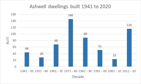
2.13 Since the Second World War the number of houses in Ashwell has more than doubled. The local council started building houses in the late 1940s and continued into the 1960s. From the 1970s onwards private estates such as Woodforde Close, The Rickyard, Fordham Close and Angell's Meadow were built. More recently, Colbron Close and John Sale Close were built, see Figure 2.2
2.14 In the last 15 years significant housing developments have been added with the building of Walkdens (27 units in two phases), and Philosophers Gate (19 units), both off Station Road on the East side of Ashwell. Both of these developments include affordable or starter homes with some rental provision included in the former. Figure 2.2 shows the units built since 1945 and 2019, which is shown as a graphic in Figure 2.3 .
|
Location |
Units |
Location |
Units |
Location |
Units |
|
|
1945-50 |
Dixies Close |
44 |
||||
|
Total |
44 |
|||||
|
1951-60 |
Ashwell Street |
11 |
Toppers, Ashwell St. |
1 |
Bear Lane |
7 |
|
2-12 Lucas Lane |
5 |
Station Rd. |
3 |
West End |
1 |
|
|
Total |
28 |
|||||
|
1961-70 |
Ashwell St. |
12 |
41-49 Back St. |
5 |
60-70 Back St. |
6 |
|
89,91,93 Back St. |
3 |
Dairy |
1 |
8,10 Green La. |
2 |
|
|
52,54 High St. |
3 |
Hinxworth Road |
1 |
9-17 Lucas La. |
6 |
|
|
Brewery, Mill St. |
4 |
Newnham Way |
5 |
Sunnymead |
17 |
|
|
Westbury Farm Cottages |
2 |
West End |
1 |
|||
|
Total |
68 |
|||||
|
1971-80 |
Angell's Meadow |
46 |
Ashwell St. |
4 |
Bear Farm |
12 |
|
Fordham Close |
7 |
1-3 Green La. |
2 |
1 High St. |
1 |
|
|
4 High St. |
1 |
46,48 High St. |
2 |
47,49 High St. |
2 |
|
|
51,51A,51B High St. |
3 |
95 High St. |
1 |
Hinxworth Rd. |
1 |
|
|
The Mill |
1 |
Rickyard |
8 |
28,30 Silver St. |
2 |
|
|
38 Silver St. |
1 |
Springhead |
1 |
Station Rd. |
2 |
|
|
3,5 Swan St. |
2 |
15 Swan St. |
1 |
Wolverley House |
23 |
|
|
Woodforde Close |
22 |
Gate House, Mill Street |
1 |
|||
|
Total |
146 |
|||||
|
1981-90 |
Ashwell End |
1 |
7 Ashwell St. |
1 |
85 Back St. |
2 |
|
Bacons Yard |
16 |
Dixies Farm |
11 |
Dovecote |
6 |
|
|
Maltings |
22 |
Partridge Hill |
1 |
Sales Acre |
1 |
|
|
37 Silver St. |
3 |
Sunnymead |
10 |
Westbury Barns |
7 |
|
|
Wolverley House |
8 |
|||||
|
Total |
89 |
|||||
|
1991-00 |
Ashwell End |
1 |
3 Ashwell St. |
1 |
5 Ashwell St. |
1 |
|
Ashwell End |
1 |
Colbron Close |
16 |
Ducklake |
4 |
|
|
Gardiners La. |
1 |
22 High St. |
2 |
John Sale Close |
10 |
|
|
Merchant Taylors |
5 |
Moules Yard |
4 |
Silver Court |
4 |
|
|
Westbury Farm |
1 |
|||||
|
Total |
51 |
|||||
|
2001-10 |
59 Ashwell St. |
1 |
Farrows Farm |
3 |
Newnham Way |
2 |
|
Newnham Way |
1 |
37 Silver St. |
3 |
Small Gains |
1 |
|
|
Walkdens |
12 |
|||||
|
Total |
23 |
|||||
|
2011-20 |
Broadchalke Close |
3 |
Hodwell |
1 |
The Limes (Cooke) |
7 |
|
Moules Yard Extn. |
2 |
Newnham Way |
1 |
Philosopher's Gate |
19 |
|
|
Shire End |
6 |
Walkdens Extn. |
15 |
Whitby Farm |
5 |
|
|
22 Lucas La. |
1 |
94 Ashwell St. |
1 |
Old Stables, Mill St. |
1 |
|
|
48 Ashwell St. |
1 |
15 High St. |
1 |
35 High St. |
1 |
|
|
22,24 Hodwell |
2 |
15 Kingsland Way |
1 |
17 High St. |
1 |
|
|
Lucas La., opp Rec. |
4 |
East, 25 Ashwell St. |
1 |
Dixie's Close /Back St. |
2 |
|
|
Adj. 2 Ashwell St. |
1 |
Townsend Field, Station Rd |
9 |
Rear 4-14 Claybush Hill |
30 |
|
|
Total |
116 |
Figure 2.2 Number of units built by decade since 1945
|
|
|
Figure 2.3 Housing growth in Ashwell 1941 to 2020 |
Profile of the community today and key challenges
2.15 A detailed profile of the parish is provided in Appendix A. In summary, the key aspects of the profile of the neighbourhood area, as they relate to the ANP, are as follows[2]:
- The rural nature of the parish is treasured among locals and has evolved over time. There is a need to protect Ashwell from overdevelopment that would change the nature and setting of the parish.
- The parish is rich in designated environmental and historic assets and any growth must be undertaken sympathetically, maximising the preservation of such assets while enabling people to enjoy them.
- Ashwell parish has an ageing population, with a high number of those being in the two oldest age brackets: 45 to 64 and over 65. These age brackets grew significantly between 2001 and 2011.
- There are few adults aged between 25 and 44 years old, an age bracket that dropped considerably between 2001 and 2011.
- There is a fairly high number of children (and teenagers) in the parish when compared to the district as a whole. This may be due to the attractiveness of the parish and the presence of a good primary school.
- The parish has a high proportion of larger, detached homes. The vast majority of homes are owned. There is a trend toward under-occupancy in the parish (i.e. houses with more rooms than deemed useable given the number of occupants), which might suggest that there are insufficient numbers of houses to downsize to. The village needs smaller homes, including affordable ones that are suited to young couples and families, and to those wishing to downsize. Enabling those who want to downsize will free up larger, under-occupied homes for growing families. Measures like this would help to bring younger people to the parish, which in turn may help to sustain local services and facilities.
- Affordability of housing is an issue locally, where average incomes put even affordable market housing out of reach. The percentage of social and private rental properties is low when compared to the district, restricting options for those on modest or median incomes to move to the parish. Two developments that have taken place since the 2011 Census have made a start on redressing this imbalance.
- There is a need to ensure that the village centre continues to provide the services required by the local community, including sustaining the school, local health facilities and shops.
- A key priority for residents is continued access to healthcare, and there is a keenness among residents to maintain the existing provision of the surgery, pharmacy and dental services.
- Equally, the viability of the primary school is important and links very much to the need to provide the type of housing that will enable families to continue to move to the area.
- The nearest railway station (Ashwell and Morden) is four kilometres distant and safely accessible only by car owing to the lack of a footway, a dangerous bend along the road with a 60mph speed limit and absence of street lighting. Other stations are also a drive away at Baldock, Royston and Letchworth Garden City. The parish has bus links to several major employment centres, however off-peak services, and those to the more rural parts are infrequent.
- The parish hashigher than UK average levels of car ownership, with an average of 1.6 cars per household across the area compared to 1.2 at the national level. Higher car ownership is not unexpected in more rural areas, however it will be important to ensure that public transport is adequate for those with limited access, particularly given that 11% of residents have no access to a car at all.
- High levels of car ownership mean that congestion is a problem, particularly in the more historic parts of the village where roads are narrower and houses have been built without off-street parking. The situation is exacerbated by the limited bus service.
- Parking generally is in short supply and off-street parking particularly so.
- Unemployment is low with many people working from home and levels of home working are likely to increase in the future. Whilst a few people work in the Parish or nearby, the majority travel between 10km and 40km to work, suggesting high levels of out-commuting. It will be important to safeguard employment in the Parish and to help those who work from home, given the high numbers in this category.
- The resident population is well-qualified. It will be important to consider ways to provide additional higher paid jobs locally or improve links to neighbouring settlements that are less reliant on the use of the car. Providing the necessary infrastructure for home-workers is important.
[2] Based on Census 2011 unless otherwise specified