Preston Parish Neighbourhood Plan 2018 - 2031 - February 2019
C.1 Context
This small and oddly shaped parish stretches about 3 miles across the Chiltern escarpment. Variations in altitude and gradient, and in soil type and depth, give a constant change in scenery, as one travels through the parish, on foot, horse, cycle or by car. These subtle changes are reflected in the pattern of habitats which now exist. Throughout at least ten centuries, people have lived and worked in this short and narrow slice of Hertfordshire's countryside.
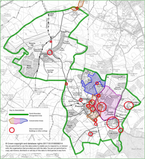
As discussed further in this appendix the parish contains 2 Conservation Areas, a Registered Historic Park and Garden, 63 Listed Buildings and Structures, as well as 1 Site of Special Scientific Interest.
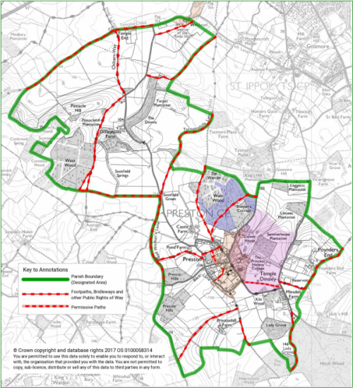
Footpaths, Bridleways and Green Lanes
There is a well-used network of Public Rights of Way (including part of the Chiltern Way, many footpaths, bridleways and green lanes) as well as permissive paths through the churchyard to the Millennium Meadow and across a field in the grounds of PHC, formerly known as Princess Helena College.
Views and Vistas
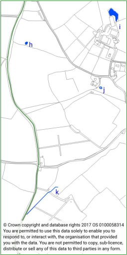
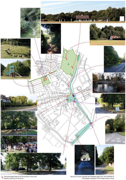
The residents value the views and vistas afforded by our setting. Below is a map from the survey which is indicative of the views, not definitive.
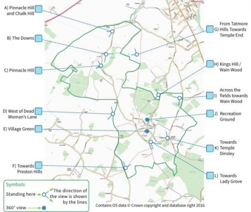
The following photographs illustrate some of the views and vistas from the above map and the Distinct Villages map on page 67
C) Pinnacle Hill
B) The Downs
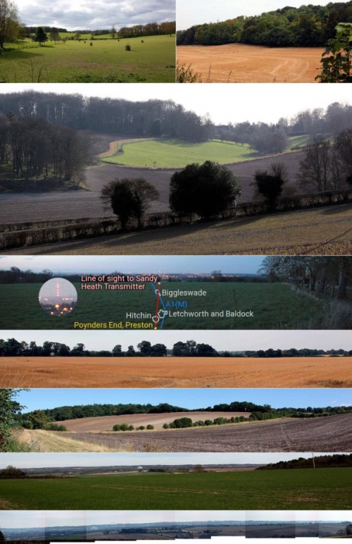
K) Towards Temple Dinsley
Looking South from Sootfield Green
F) Towards Preston Hills
Standing at Poynders End looking towards Stevenage. This is just from one angle. Below is a panorama of the horizon stitched together from multiple photographs.
Distinct Villages
The views from Preston across open countryside are highly appreciated by residents and visitors alike. To the east and north in particular they stretch beyond the neighbouring town of Hitchin to open countryside. From Sootfield Green and Poynders End the Sandy Heath Transmitting Station, some 15 miles (24 Km) to the north as the crow flies, can be seen. To the west the views flow down and across the valley to where cows and sheep graze and to woodland beyond.
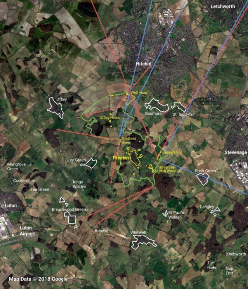
Some of the views are suggested by straight lines. Preston Village, smaller settlements and individual farms/houses within the parish are shown with a yellow border. Preston Parish boundary is shown in green. The more noticeable of the neighbouring settlements have a white border.
C.2 Natural Environment
Areas, habitats and species with legal protection.
This Appendix gives data which supplements that given in Section 10, Environment and Heritage, in the Preston Parish Neighbourhood Plan.
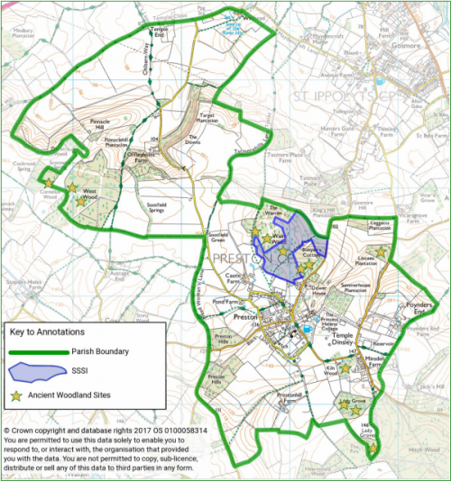
Site of Special Scientific Interest
Natural England has designated part of Wain Wood as a Site of Special Scientific Interest under Section 28 of the Wildlife and Countryside Act 1981 (shaded blue on the above map). It is an area of diverse flora and ancient deciduous woodland, known to have existed before 1600. The SSSI zone is only 19.03 hectares of the total wood of 31.02 hectares. Felling and removal of conifers in the summer of 2017 from the areas of ancient woodland surrounding the SSSI zone may enrich the biodiversity of this valuable habitat.
The details of the designation (as of December 2017) are as follows:
Wain Wood (TL 180255, Area: 19.2 ha, 47.4 acres) is the only SSSI in the parish. An ancient seat natural oak/hornbeam (Quercusspecies/Carpinusbetulus) woodland, which is notable as it is near the northern limit of its natural range, and is a habitat that is now much reduced in extent nationally through woodland clearance or felling and restocking with conifers.
The stand comprises mature pedunculate oak Quercusrobur and sessile oak Quercuspetraea with hornbeam standards in the south and wild cherry Prunusavium frequent in the north. Thinly developed hornbeam coppice dominates the shrub layer throughout with elder Sambucusnigraalso present. Here the sparse ground flora is composed of bluebell Hyacinthoidesnon-scripta, bramble Rubusfruticosus, bracken Pteridiumaquilinum and bryophytes. A disused pit near the centre of the wood is surrounded by standard ash Fraxinusexcelsior and wild cherry with abundant dog's mercury Mercurialisperennis as ground cover.
A damp open ride in the south of the wood is characteristic of unimproved acidic grassland with sheep's sorrel Rumexacetosella, yellow pimpernel Lysimachianemorum and common centaury Centauriumerythraea. Elsewhere, drier more base-rich conditions support a ride flora indicative of calcareous grassland. Species present include field scabious Knautiaarvensis, hairy St John's wort Hypericumhirsutum, lady's mantle Alchemillafilicaulis and eyebright Euphrasiaofficinalis.
The wood is said to support an interesting butterfly community, including the near threatened and scarce purple hairstreak butterfly, Theclaquercus,but there are no recent records.
The accounts of the woodward, John Merrit, 1739-1767 survive and are part of the Delme Radcliffe Collection at the County Archive Office, Hertford. Within the wood is a large and deep natural amphitheatre, known as Bunyan's Dell, because John Bunyan, (1628-1688), the Bedfordshire Baptist preacher, held clandestine gatherings here for his followers. Bunyan is thought to have stayed overnight at Bunyan's Cottage, a timber-framed 17th century building in the wood.
The Ancient Woodland Inventory Sites
Ancient woodland is land that has had a continuous cover of woodland since at least 1600. There are two categories:
ASNW Ancient semi-natural woodland or ASNW sites: 6 in Preston Parish. These include parts of Hitch Wood and of Hearnsfield Wood, and one part of West Wood and Goodley's Wood.
PAWS Planted ancient woodland site or PAWS sites: 7 in Preston Parish. These are sites where the original tree cover has been felled and replaced by planting, probably of conifers in the 20th century. These include parts of Wain Wood, the Linces Plantation, and in the north west of the parish, Cockrood Springs and Scotswick Springs, and the larger part, 24 hectares, of West Wood and Goodley's Wood.
|
|
Sitename |
GridRef. |
Category |
Total area(ha.) |
|
1. |
Linces Plantation |
TL188255 |
PAWS |
0.40 |
|
2. |
Wain Wood |
TL182254 |
PAWS |
0.73 |
|
3. |
Wain Wood |
TL178255 |
PAWS |
5.46 |
|
4. |
Wain Wood |
TL 179254 |
ASNW |
19.10 |
|
5. |
Wain Wood |
TL 181253 |
PAWS |
4.54 |
|
6. |
The Warren |
TL176256 |
ASNW |
1.19 |
|
7. |
Ladygrove North (Kiln Wood) |
TL185243 |
PAWS |
1.78 |
|
8. |
Ladygrove South |
TL186239 |
ASNW |
2.61 |
|
9. |
Ladygrove South |
TL185240 |
PAWS |
3.24 |
|
10. |
Hitch Wood |
TL191234 |
ASNW |
65.38 |
|
11. |
West Wood |
TL161259 |
PAWS |
24.29 |
|
12. |
Goodleys Wood |
TL160260 |
ASNW |
6.21 |
|
13. |
Cockrood/Scotswick Spring |
TL 156260 |
ASNW |
2.41 |
PAWS = Plantation on Ancient Woodland Site ASNW = Ancient Semi-Natural Woodland
Note: Only a very small area of the Hitch Wood/The Firs/Ladygrove South/Hearnsfield Wood complex of woodlands lies within Preston Parish.
The Local Wildlife Sites
There are 9 Local Wildlife Sites. The habitats include woodland, ponds and chalk grassland.
The local wildlife sites are non-statutory sites designated at County and District level as being of conservation importance. The aim of this identification is twofold: to protect such sites from land management changes which may lessen their nature conservation interest, and to encourage sensitive management to maintain and enhance their importance.
In Hertfordshire, ecologists seek permission from landowners to access areas; they then use robust, scientifically determined criteria and detailed surveys to identify potential sites. The selection of sites is based on the most important, distinctive and threatened species and habitats within a national, regional and local context. Ratification of each selected site is awarded by the Hertfordshire Local Wildlife Sites Partnership; this status is recognised by Natural England.
Although Local Wildlife Sites have no statutory protection, they need to be considered in the planning process through the guidance provided by the National Planning and Policy Framework, which states that to minimise impacts on biodiversity and geodiversity, planning policies should identify and map components of the local ecological networks, including locally designated sites of importance for biodiversity, and promote their preservation and restoration. Plans should be concerned not only with designated areas, but also with other land of conservation value and the possible provision of new habitats.
Other Non-Statutory Sites of Parish Importance
These are sites of conservation importance which require protection from any changes which may lessen their ecological importance.
- Woodland: 1
Preston Hills Wood TL173246, buzzards and red kites breeding here.
- Ponds: 11 and Streams: 2
Historically, Preston Parish has had more ponds, due to rainwater collecting in natural depressions in the clay soil, the maintenance of a 'puddled' clay lining, and the need for livestock to thrive, before a piped water supply became available.
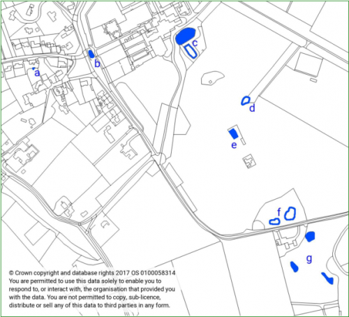
See list of ponds with map grid references on following page.
|
a |
TL179247 |
Pond behind Old Forge |
|
b |
TL180247 |
Village Green Pond –for more detail see Local Blue Space Assessment, page 78 |
|
c |
TL182248 |
Pond(s) adjacent to Temple Dinsley House OS Maps and Data show two ponds, aerial imaging shows only the north of the two having water |
|
d |
TL183246 |
Pond in PHC Field OS Maps and Data show a pond, aerial imaging shows a surface feature but cannot see water – possibly now seasonal or dried up |
|
e |
TL183246 |
Pond Believed to have been dug as a reservoir when the Estate water supply (using the header tank in the adjoining barn) was constructed in the early years of the 20th Century. Shows as water on aerial imagery, regular shape on OS Master Map Data, does not show on OS1:25000 map |
|
f |
TL184244 |
Ponds or standing water Visible from School Lane – possibly seasonal. Not shown on OS Master Map data or1:25000 Map |
|
g |
TL185244 TL184243 TL185243 |
3 Ponds in Ladygrove North (Kiln Wood) |
 Ponds and Stream
to West
of Village
Ponds and Stream
to West
of Village
|
h |
TL172251 |
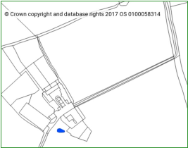
Pond near Sootfield Green, in field between Dead Woman's Laneand Charlton Road |
|
i |
TL176252 |
Pond to north of buildings at Castle Farm |
|
j |
TL175249 |
Evidence of former pond at The Pond Farmhouse Still shown on OS maps and data but aerial imagery and observations from public footpath only show evidence of a former pond |
|
k |
TL173243 to TL172242 |
OS 1:25000 map shows a stream or watercourse Aerial imagery shows features that may once have been a water course – water has been seen flowing from the wood into the roadside gulley in living memory |
Preston Hill Farm Pond - TL179239 Source of the River Hiz- TL174275
- St. Martin's Churchyard TL178248
On this one acre of land, there is an avenue of Irish yews, planted soon after 1900 and recently coppiced, tall conifers with an understorey of brambles along the boundary fence, and, on the gravestones, many lichens. Hedgehogs, tawny owls, gold crests and green woodpeckers are recent recordings.
- Green Lanes: 2
Dead Woman's Lane and its northern extension, Tatmore Hills Lane, are ancient trackways with tall hedges and solid banks; they act today as vital corridors of shelter and food supply for many species. Bats, linnets, yellowhammers, and among the flora, ransoms, dog's mercury, red bartsia, knapweed as well as bluebells have all been recorded.
- A Former Park: 1
To the north of the 17th Century Offley Holes Farmhouse, lies an area of pasture with occasional trees, partly edged by metal railings. This is the legacy of a small landscape park of the 19th century, when there were over 200 parks throughout Hertfordshire. Hugh Prince charts its development, as follows:
|
Size in acres |
Owner |
Source |
|
50 |
Rev. Lynch Burroughs |
Bryant's Map of Hertfordshire, 1821 |
|
40 |
Richard Marsh |
OS 1st edition, 6'' map, 1863-1881 |
Cattle and sheep now regularly graze this pasture, a rare sight in the farming scenes in North Hertfordshire today. This grassland also provides a valuable food supply for small mammals, insects and grassland birds, amongst the arable acreage in the north of the parish.
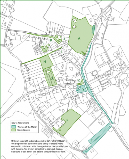
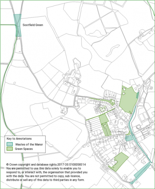
- Green Spaces
Public green spaces, such as The Green, the Recreation Ground and Church Meadow, and privately owned green spaces such as the churchyard, the meadow off Back Lane and the NHDC field and the abundance of gardens across the village, not only contribute visually to the open spacious feel of the 'village scape', but now contribute generously to the food and shelter available to many wildlife species, especially birds, insects, amphibians and small mammals.
Green Spaces: 12 plus verges
The village benefits from the following green spaces, some of which are "Wastes of the Manor".
|
A |
Cricket and Recreation Ground – adjacent to Hitchin Road. One corner is also a Waste of the Manor – for more detail see Local Green Space Assessment, page 77 |
|
|
B |
The verge running from opposite the Recreation Ground to the entrance of PHC and including the Village Green Pond –for more detail see Local Green Space Assessment, page 78 |
Waste of the Manor |
|
C |
The grass verge between Preston House and the Village Green. – for more detail see Local Green Space Assessment, page 79 |
|
|
D |
The Village Green, including the area with the Village Well and Telephone Box – for more detail see Local Green Space Assessment, page 79 |
Waste of the Manor |
|
E |
The verges either side of the lane and the triangle
in the fork of the lane along Crunnells Green
|
Waste of the Manor |
|
F |
PrestonPrimarySchoolPlaying Fields |
|
|
G |
St. Martin'sChurchyard |
|
|
H |
The Millennium Play Ground – accessible via the Churchyard and Chiltern Way Extension Footpath – for more detail see Local Green Space Assessment, page 81 |
|
|
I |
Chiltern Way Extension Footpath – At the Chequers Lane end and the Millennium Playground this is wide enough to be considered a green space as well as a path – for more detail see Local Green Space Assessment, page 81 |
|
|
J |
The grass verges around the car park in Chequers Lane |
TL179249 |
|
K |
The grass verges in front of 15 to 25 Chequers Lane |
|
|
L |
The grass area enclosed by 1 to 6 Templars Lane |
|
In addition to these, many of the roadside verges throughout the village are green spaces that provide vantage points to view the countryside, refuge from traffic for pedestrians, as well as in some places a surface on which dogs and humans can walk. Some of the verges merge seamlessly into frontages and gardens. All of this forms a key part of the rural character of the lanes in the parish.
The footpaths, bridleways and green lanes are often wide enough to be considered as green spaces as well as Rights of Way.
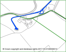
There is also a Waste of the Manor at Sootfield Green as shown below
Local Green and Blue Space Assessment
|
Site |
Cricket and Recreation Ground |
|
Address / Location |
Entrance from and adjacent to Hitchin Road. Also backs on to Wain Wood. |
|
Ref in this plan |
Green Space A |
|
Section / Page Ref |
Appendix C.2, page 73 |
|
Grid Ref |
TL180249 (of Entrance) |
|
Description and purpose |
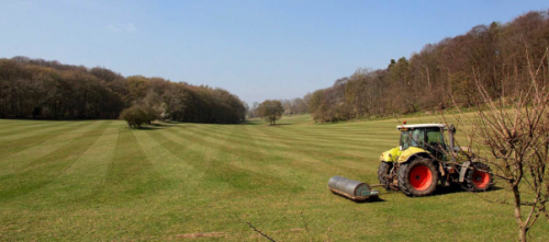
An open playing field, surrounded by woodland and gardens. Bounded by hedges including a cob hedge to Hitchin Road. It contains: Recreation Equipment for Older Children; Sports Pavilion; Cricket Pitch, Practice Nets and Electronic Scoreboard. |
|
Ownership |
Preston Parish Council - One corner is also a Waste of the Manor |
|
CheckList |
|
|
Statutory designations (e.g. SSSI) |
Sits within the Preston Conservation Area. Adjoins Wain Wood SSSI. |
|
Site Allocations (give details) |
None |
|
Planning permissions (give details) |
None |
|
NPPF Criteria |
|
|
Proximity to the community it serves |
Within main settlement of Village |
|
Local Significance |
|
|
Recreation Value |
Open space for walking and sports. Cricket - matches, practice and junior team coaching; Recreation space for older children. |
|
Beauty |
The ground affords a 360 degree panoramic view of trees and hedges. |
|
Historic Value |
Home of Preston Cricket Club, first founded in 1882 and playing at this site since 1919. The Pavilion is listed as an Undesignated Heritage Asset and may be worthy of listing in future. |
|
Tranquillity |
The ground is often quiet providing a space for walking and reflection. |
|
Wildlife |
Surrounded by hedges and woodland with a Cob Hedge adjoining Hitchin Road. This provides a large open habitat for birds and small mammals as with any space occasionally used by people. |
|
Extensive Tract |
No |
|
Site |
Vergeagainst PHC Wall |
Village Pond (Blue Space) |
|
Address / Location |
The verge running from opposite the Recreation Ground to the entrance of PHC and including the Village Green Pond. |
Located on the "Verge against PHC Wall" opposite the Village Green. |
|
Ref in this plan |
Green Space B |
Blue Space b (note lower case key used for blue spaces) |
|
Section / Page Ref |
Appendix C.2, page 73 |
Appendix C.2, page 71 |
|
Grid Ref |
TL180249 to TL181245 |
TL180247 |
|
Description and purpose |
A wide verge ranging from hedgerow and scrub to mown lawn with ornamental trees and planted bulbs. The verge provides refuge for pedestrians, places to sit, extra space for events on the village green and visual amenity. The old cart pond is sited on this verge - see Village Pond. |
This is the former cart pond. It been partially restored and provides run off of rain water that would otherwise flood Hitchin Road. It provides visual amenity with seating in the form of a bench on the south side. |
|
Ownership |
Waste of the Manor |
Waste of the Manor |
|
Check List |
|
|
|
Statutory designations (e.g. SSSI) |
Sits within the Preston Conservation Area. Adjoins Temple Dinsley - Register of Historic Parks and Gardens under which the wall and gate piers are Grade II listed. |
Sits within the Preston Conservation Area. Adjoins Temple Dinsley. |
|
Site Allocations (give details) |
None |
None |
|
Planning permissions (give details) |
None |
None |
|
NPPF Criteria |
|
|
|
Proximity to the community it serves |
Within main settlement of Village |
Within main settlement of Village |
|
Local Significance |
|
|
|
Recreation Value |
Open Space for walking, sitting and extra space for village events. |
None |
|
Beauty |
Affords views of PHC Wall, a space from which to enjoy looking across the Village Green and of high visual amenity in its own right. |
Enhances the verge and Village Green. |
|
Historic Value |
The Wall is Grade II listed. |
Partially restored cart pond - photographic records from late 19th /early 20th century show size and location. It was filled in during the 1950s and restored in 2008 without cart access. |
|
Tranquillity |
Absorbs road noise enhancing tranquillity of the village. |
Part of the tranquillity of the setting. |
|
Wildlife |
Provides a green corridor from opposite the Recreation Ground to Crunnells Green. |
Provides water for birds and animals as well as a habitat for aquatic and amphibious species. |
|
Extensive Tract |
No |
No |
|
Site |
Verge between Preston House and the Village Green |
The Village Green and Well |
|
Address / Location |
Between Preston House and The Village Green - on the corner of Church Lane and School Lane. |
The Village Green, including the area with the Grade II Village Well and Grade II Listed Telephone Box. Bounded by: The Red Lion public house (Grade II listed) to the South; School Lane and PHC Wall to the East; Church Lane to the North. |
|
Ref in this plan |
Green Space C |
Green Space D |
|
Section / Page Ref |
Appendix C.2, page 73 |
Appendix C.2, page 73 |
|
Grid Ref |
TL180247 |
TL180247 |
|
Description and purpose |
This is a mown lawn verge with a footpath running across to a matching drop kerb on the green. It provides a refuge for foot traffic, additional space for village events on the Green and visual amenity. |
The Village Green, including the area with the Village Well, Telephone Box and Parish Noticeboard. An area of mown lawn with a canopy of mature trees and newer plantings. Provides a meeting point for social interactions. Hosts events such as Village Day, Open Gardens Refreshments and Plant Stall. Green space for informal play and relaxation. Provides visual amenity. |
|
Ownership |
Hertfordshire County Council |
Waste of the Manor |
|
Check List |
|
|
|
Statutory designations (e.g. SSSI) |
Sits within the Preston Conservation Area. |
Sits within the Preston Conservation Area. |
|
Site Allocations (give details) |
None |
None |
|
Planning permissions (give details) |
None |
None |
|
NPPF Criteria |
|
|
|
Proximity to the community it serves |
Within main settlement of Village |
Within main settlement of Village |
|
Local Significance |
|
|
|
Recreation Value |
Additional space for village events. |
Hosts events such as Village Day, Open Gardens Refreshments and Plant Stall. Green space for informal play and relaxation. |
|
Beauty |
Adds to general openness and enhances the setting of the Green. |
This is the rural heart of the Village. To many it defines what Preston is about visually. See: front cover of Neighbourhood Plan, images of Maypole Dancing, The Well, Phone Box and Red Lion on pages 6, 14, 40 and 48. |
|
Historic Value |
None |
Photographic evidence of grazing early 20th century. |
|
Tranquillity |
Part of the tranquillity of the setting. |
A tranquil heart of the village - even dampening noise when hosting village events. |
|
Wildlife |
Minimal |
The tree canopy provides a habitat for birds and insects. |
|
Extensive Tract |
No |
No |
|
Site |
Verges along Crunnells Green |
|
Address / Location |
Either side of Crunnells Green (a lane connecting School Lane to Back Lane), including a triangle of land in the road at the junction of Crunnells Green and Back Lane. |
|
Ref in this plan |
Green Space E |
|
Section / Page Ref |
Appendix C.2, page 73 |
|
Grid Ref |
TL181245 to TL180244 |
|
Description and purpose |
The verges consist of secondary woodland (giving a canopy across the lane) and the triangle of land has rough grass with trees providing a canopy. No purpose other than providing the setting of a rural lane. |
|
Ownership |
Waste of the Manor |
|
Check List |
|
|
Statutory designations (e.g. SSSI) |
Sits within the Preston Conservation Area. |
|
Site Allocations (give details) |
None |
|
Planning permissions (give details) |
None |
|
NPPF Criteria |
|
|
Proximity to the community it serves |
Within main settlement of Village |
|
Local Significance |
|
|
Recreation Value |
None |
|
Beauty |
Providing the setting of a rural lane. See image of couple walking along Crunnells Green on page 6. |
|
Historic Value |
None |
|
Tranquillity |
Verges absorb noise. |
|
Wildlife |
Provides much needed habitat of undisturbed deep hedge rows and secondary woodland. |
|
Extensive Tract |
No |
|
Site |
Millennium Playground |
Chiltern Way Extension Footpath |
|
Address / Location |
Not bounded by any roads. Accessible via the Churchyard and Chiltern Way Extension Footpath. Lies to the North of the Churchyard. |
Connects Butchers Lane, Castlefield Foot Entrance, Millennium Playground and Chequers Lane (with rear access for Chequers Cottages). |
|
Ref in this plan |
Green Space H |
Green Space I |
|
Section / Page Ref |
Appendix C.2, page 73 |
Appendix C.2, page 73 |
|
Grid Ref |
TL178248 |
TL177248 to TL179249 |
|
Description and purpose |
A parcel of land which has been rescued from brambles to include a play area for young children, an orchard, and a footpath connecting the rear of the churchyard with the Chiltern Way Extension. Much of the wilderness has been retained to mitigate noise from play and encourage wildlife. |
Public Right of Way - see Address above for locations served. At the Chequers Lane end and the Millennium Playground this is wide enough to be considered a green space as well as a path. |
|
Ownership |
NHDC - Leased to Preston Parish Council |
Hertfordshire County Council Rights of Way |
|
Check List |
|
|
|
Statutory designations (e.g. SSSI) |
Adjoins the Preston Conservation Area. |
Eastern End within the Preston Conservation Area. |
|
Site Allocations (give details) |
None |
None |
|
Planning permissions (give details) |
None |
None |
|
NPPF Criteria |
|
|
|
Proximity to the community it serves |
Within main settlement of Village |
Within main settlement of Village |
|
Local Significance |
|
|
|
Recreation Value |
Playground with equipment for younger children. Fruit trees for use by local residents. |
Part of longer walk which provides relaxation and leisure for many people not only Preston residents. |
|
Beauty |
Provides a green oasis between the surrounding residential properties of Church Lane, Chequers Lane (including Templars Lane) and Butchers Lane. |
Attractive at the Chequers Lane end where protected by the Conservation Area. Marred at the other end by a tall green metal fence separating it from the meadow of Castlefield. |
|
Historic Value |
None |
None known |
|
Tranquillity |
Parents comment that it is so quiet it helps the children calm down. |
Provides a quiet pedestrian route. |
|
Wildlife |
Provides a diverse range of habitats supporting native species of plants, small mammals, birds and insects. |
A corridor for wildlife affording hedgerow habitats. |
|
Extensive Tract |
No |
No |
Photographs of Local Open Greenand Blue Spaces
Species Data for theParish
The National Biodiversity Network Trust, a registered charity, organises nationally, the collation of biodiversity data and maintains the NBN Atlas. The Hertfordshire Environmental Records Centre at St. Albans collaborates with the NBNT. The NBN database records 13,375 entries for this parish; these entries are submitted by both professional and expert amateur ecologists, after fieldwork surveys in the parish.
The number of species (shown in brackets) of the flora and the fauna give us an insight into what is living in, and sharing, the environment of our parish:
es (23)
|
Animals: |
Mammals (21) Birds ( |
86) Amphibians (3) Reptiles (1) |
||
|
Insects: |
Beetles (7) Butterflies (21) Moths |
(22) True bugs (5) |
||
|
Plants: |
Conifers (4) Ferns |
(2) Flowering plants (329) Horsetail (1) |
||
|
Bryophytes & Algae: Lichens (34) Liverworts (2) Moss |
|
|||
|
|
|
|
|
|
Total number of different species: 561, all having been seen and identified in this parish in recent decades. It is likely that this seemingly high figure is not the full total. Expertise and time are needed to notice and to identify all species, in every season, year by year; the availability of skilled ecologists/observers is essential for a fuller recording of all species.
Within the fauna, the parish has some species which are protected under both national and European legislation:
The NERC Act is the Natural Environment and Rural Communities Act of 2006.
- Amphibians: common frog, common toad and smooth newt: all are Species of Principal Importance, Section 41 NERC Act.
- Birds: willow tit, lesser spotted woodpecker, lesser redpoll: all are 'Woodland Red Listed Birds', and Species of Principal Importance, Section 41 NERC Act.
- Birds: grey partridge, spotted flycatcher, yellowhammer, corn bunting, linnet: all are 'Grassland Birds of Conservation Concern Red listed species', and Species of Principal Importance, Section 41 NERC Act.
- Birds: swift, short-eared owl, common redpoll: these are 'Birds of Conservation Concern Amber listed species'.
- Lichens: The lichen, Flavoplacadichroa, was recorded in the parish in 2012, and is 'Nationally Scarce'.
- Reptiles: The slow worm, Anguisfragilis, has been recorded, and is a Species of Principal Importance, Section 41 NERC Act.
- Mammals: brown hare: this is a Species of Principal Importance, Section 41, NERC Act.
- Mammals: bats: 5 species have been recorded in the parish: all are European Protected Species, also Species of Principal Importance, Section 41 NERC Act. The 5 species are: common pipistrelle, brown long-eared, Myotisspp., the natterer, the daubenton.
Farming andthe Environment
For centuries, farming has had a greater effect on the landscape and all habitats than any other human activity. Recent changes in farming practice have often degraded the landscape and many habitats. We need to ensure that the farms have the capacity to produce food and so sustain the nation's human population. But, since the Department of the Environment's 'Countryside Survey' in the 1980s, government legislation has, through the Set-Aside Schemes, required farmers to give greater consideration to the flora and the fauna of their local farmland.
In 2016, a new Countryside Stewardship Scheme, with Single Farm Payments offering capital grants towards supporting and enhancing environmental sustainability, has taken this policy a step further.
Within this small parish, there is a wide diversity of habitats. We need to ensure that these are maintained, restored and enriched. With detailed ecological data available, sites can be identified for habitat creation. The new Stewardship Scheme can assist with creating 'wildlife corridors' within and across the parish, linking one grassland with another, one woodland with another, along a network of botanically diverse hedgerows, verges and bridleways. Sufficient well maintained ponds are needed to enable many species to survive, breed and thrive. This concept of a 'Green Infrastructure' across the parish and the wider landscape, gives some priority to the basic needs of the wildlife.
Fauna and flora do not recognise parish boundaries. The habitats straddle across our parish boundaries, for example, woodland continues into St. Paul's Walden Parish, and chalk downland continues along the Chiltern scarp slope into Offley Parish.
On a wider landscape scale, within a few miles of this parish, we have a scattering of medium and smaller size woods and spinneys, and a mosaic of historic landscaped parks. These include: Hitchin Priory Park, St. Ibbs Park, St. Paul's Walden Bury, Kings Walden Park, Offley Place and Putteridge Bury as well as our own Temple Dinsley Park. Ecologically similar habitats can be identified, and wildlife networks created and maintained. Opportunities exist to restore and generously to enrich the local environment, for the benefit of all.
C.3 Built Environment
Listed Buildings
This is a National status, and applies to 63 buildings on 42 sites in this small parish. 61 are Grade II. Two are Grade II*, which are 'particularly important buildings of more than special interest'.
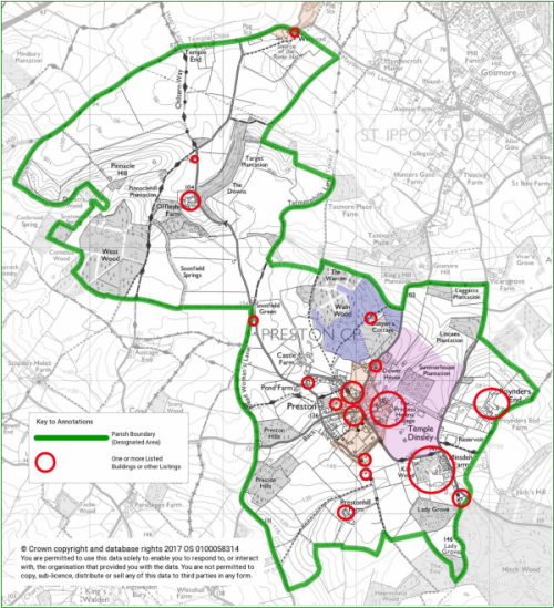
The map above and following detailed maps clearly show the present number and distribution of buildings and structures of national merit in the parish. The high number is evidence of the wealth of past residents, and of the availability of tradesmen and craftsmen to construct premises of such quality.
The Location of Listed Buildings in the Village
Note: the wall and gate piers shown in magenta are also listed.
The location of Listed Buildings, beyond the Village
Prepared by the Preston Parish Neighbourhood Plan Steering Group © 2019 Page 87 of 110
Index of Listed Buildings:
|
Name |
Listed Entry Number from Historic England |
|
Bunyan's Cottage |
LEN 1347489 |
|
Chequers Cottages 1-6 and 3 linked rear outhouses |
LEN 1176623 |
|
Crunnells Green Cottage |
LEN 1102423 |
|
Fir (Fig) Tree Cottage |
LEN 1102426 |
|
Hitchwood Cottage 1-2 and outhouse |
LEN 1176749 |
|
Kiln Wood Cottage and linked outhouse |
LEN 1102433 |
|
Laburnam Lodge (Joyners Cottage as at April 2018) |
LEN 1347481 |
|
Ladygrove Stud Farm, Dairy Cottage, Kiln Wood Lodge, LadygroveLodge |
LEN 1176799 |
|
Offley Holes Barn and Cartshed |
LEN 1102429 |
|
Offley Holes Barns |
LEN 1176723 |
|
Offley Holes Farm House |
LEN 1307781 |
|
Offley Holes 'The Lodge' |
LEN 1347484 |
|
Poynders End House |
LEN 1102431 |
|
Poynders End: Tudor House |
LEN 1102430 GRADE II* |
|
Poynders End: Tudor House Octagonal Dairy |
LEN 1176732 |
|
Preston Hill Farm: West Barn |
LEN 1347485 |
|
Preston Hill Farm: East Barn |
LEN 1176739 |
|
Princess Helena College: Ice House |
LEN 1176789 |
|
Princess Helena College: House and Formal Gardens |
LEN 1307766 GRADE II* |
|
Princess Helena College: Gate Posts and Park Wall |
LEN 1102432 |
|
Princess Helena College: The Piggery |
LEN 1347448 |
|
Princess Helena College: The Dower House |
LEN 1102427 |
|
Princess Helena College: Temple Dinsley |
LEN 1000919 Parkland GRADE II* |
|
Red Lion Public House |
LEN 1102425 |
|
Reeves Cottage |
LEN 1102424 |
|
Rose Cottage |
LEN 1102460 |
|
Sadleirs End |
LEN 1347463 |
|
Sootfield Green |
LEN 1389610 |
|
Spindle Cottage Barn |
LEN 1102428 |
|
Spindle Cottage |
LEN 1176712 |
|
St. Martin's Church: The Lychgate |
LEN 1102461 |
|
St. Martin's Church (C. of E.) |
LEN 1176631 |
|
St. Martin's Church: The Mausoleum |
LEN 1102420 |
|
St. Martin's Place |
LEN 1102421 |
|
Telephone Kiosk |
LEN 1103249 |
|
The Old Forge |
LEN 1102422 |
|
The Well on The Green |
LEN 1176692 |
|
The Wilderness |
LEN 1307843 |
|
The Chequers, with Wall and Outhouse |
LEN 1307773 |
|
Vine Cottage |
LEN 1347482 |
|
Wellhead Farm: Granary and Barn |
LEN 1102459 |
|
Wellhead Farm: South-West Barn |
LEN 1307809 |
Undesignated Heritage Assets
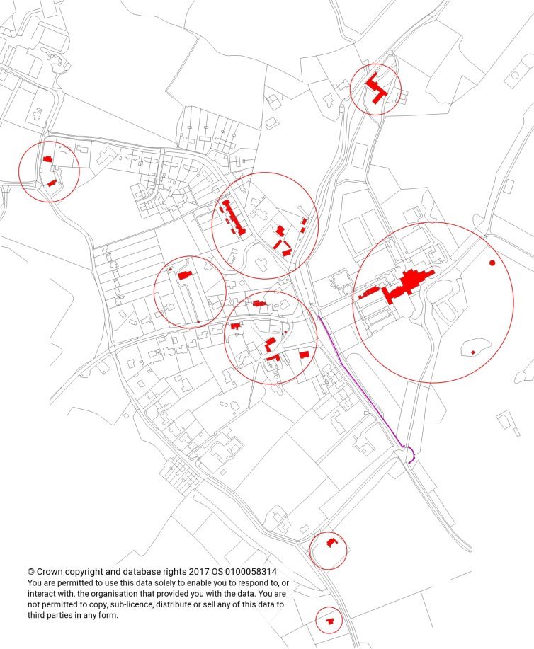
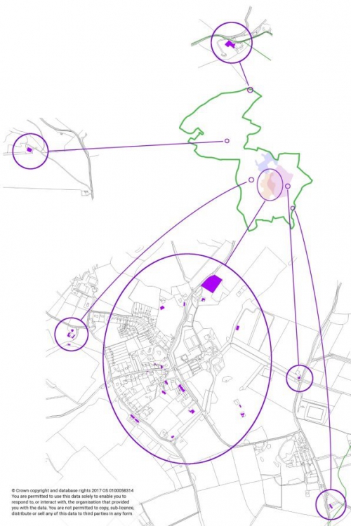
In addition to the listed buildings there are a number of undesignated buildings that have the potential to be considered as heritage assets. These are mostly located in and around the village. Areas containing the undesignated heritage assets are shown by the purple circles and oval below.
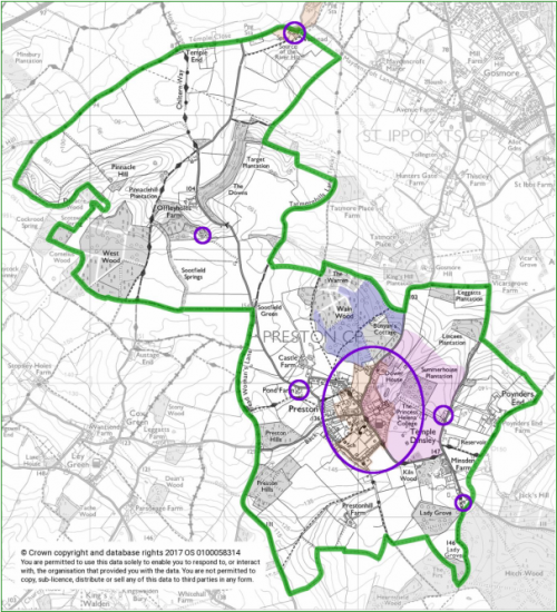
Investigating the assets and their heritage potential is a project to be undertaken outside of the Neighbourhood Plan if there are parties interested and the opportunity to do so.
Locations of Undesignated Heritage Assets
List of Undesignated Heritage Assets
|
TL175276 |
Wellhead Farm – Barns and farm buildings other than those already Grade II |
|
TL168260 |
Former Coach House of Offley Holes House |
|
TL175248 |
Open Sided Barn or Coach House at The Pond Farmhouse |
|
TL175249 |
The Pond Farmhouse and Barns / Outbuildings |
|
TL178245 |
Holly Cottages, Back Lane |
|
TL180244 |
3 Crunnells Green |
|
TL181245 |
Crunnells Green House |
|
TL187241 |
5 to 7 Hitchwood Lane (Hitchwood Cottages) |
|
TL183245 |
Barns or Agricultural Buildings in field with Permissive path in grounds of PHC |
|
TL183249 |
Barn or Agricultural Building in Summerhouse Plantation |
|
TL186247 |
1 and 2 Lodge, Temple Dinsley |
|
TL181250 |
Barn at the Dower House |
|
TL182251 |
Walled Garden (derelict) adjacent to Dower House and Preston Road |
|
TL180250 |
Barn (Conversion) beside road at the Hartings |
|
TL179250 |
Pavilion, Recreation Ground |
|
TL180247 |
Section of brick wall to garden of Preston House and Church Lane |
|
TL179247 |
John Bunyan Chapel - Now Redmayne Bentley Stock Brokers |
|
TL179247 |
Barn at St. Martin's Place, Church Lane |
|
TL179247 |
Barn at The Old Forge, Church Lane |
|
TL180247 |
Outbuilding at The Red Lion |
|
TL180247 |
Kenward Cottage |
|
TL179246 |
Pryor House |
|
TL180246 |
Village Hall and The Bungalows, School Lane |
Temple Dinsley / PHC (formerly Princess Helena College)
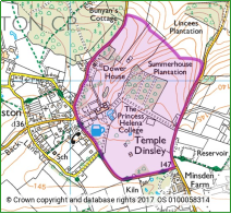
The garden and other land at Temple Dinsley are registered under the Historic Buildings and Ancient Monuments Act 1953, within the Register of Historic Parks and Gardens by English Heritage for its special historic interest (marked in magenta/pink).
Temple Dinsley has an 18th century park, and an early 20th century garden, of national merit, both are on the English Heritage Register as Grade ll*.
It is not known exactly when the 18th century park was formed. An 18th century brick ice house still exists in the park, and it is listed. Hugh Prince in his book, 'Parks in Hertfordshire since 1500' charts the development of this landscape, as follows:
|
Size in acres |
Owner |
Source |
|
65 |
Thomas Harwood |
Bryant's Map of Hertfordshire, 1821 |
|
50 |
William H. Darton |
OS 1st edition, 6'' map, 1863-1881 |
|
70 |
Countess of Carnarvon |
OS 5th edition, 1'' map, 1932-33 |
The historic Landscape Park and Gardens are now registered as 200 hectares in size. Temple Farm homestead in the southern part of the park was demolished in the early years of the 20th Century. In c.1908 Edwin Lutyens was commissioned to design and have built 'The Piggery', a small brick building with pyramidal roof, as an 'eyecatcher' feature, clearly visible from the south drive and the house. The park is laid to pasture and woodland, with the Summerhouse Plantation created in the early 20th century; these, with two small ponds, form valuable habitats for wildlife, to the south east of the village settlement. The listed 18th century Dower House stands north of Temple Dinsley house, within the registered park. The two fine pairs of gate piers and flanking walls at the entrance to the south drive, also designed by Lutyens in c.1908, are listed, as is the park wall.
The Gardens and Pleasure Grounds were laid out by Lutyens, with planting designs by Gertrude Jekyll, c.1909-1910. No planting plans still exist. The hard landscaping of brick walls and terraces, the York stone steps and paths, the brick loggia and belvedere are all to be seen in situ today, and make clear the 8 main compartments or 'rooms' of the original plan: the Rose Garden, the 2nd Rose Garden, the Herbaceous Garden, the smaller Herbaceous Garden, the Diamond Garden, the Spring Garden, the Pool Garden and the Pergola Garden. Lutyens's ornamental pool has become a swimming pool for the PHC students; this is much enjoyed by the residents of the parish and their families in the summer holidays. The Hertfordshire Gardens Trust assisted with some restoration of The Rose Garden in 1993, and the rose growers, Harkness of Hitchin, supplied new rose bushes, as the firm had done in 1909. Today, the planting throughout the gardens is much simplified from the exuberance of the Edwardian days, when labour was cheaper.
Preston Conservation Area
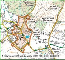
Much of the present village, the house and gardens of Temple Dinsley lie within the Preston Conservation Area.
The central core of this historic village was awarded this designation on 8th June 1970. This area (marked in orange) includes houses of different ages, sizes and materials, with their gardens, The Green and the four lanes and the one footpath which all converge there, and, also, the house and formal gardens of PHC. There are 33 Listed Buildings within the designated Conservation Area.
Charlton Conservation Area
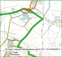 The area
was designated on 12th September 1977. The southernmost tip
of this area falls inside the Parish of Preston. The
sloping fields surrounding the Wellhead Farm spring source
of the River Hiz, allow rainwater to percolate through the
soil and thus contribute to the volume and flow in the
spring. The valley shape is shallow, the river channel
narrow, and the flow of water now much more irregular than
it was 30 years ago, but, in an otherwise somewhat dry
landscape, this feature is of real significance and
deserves full protection.
The area
was designated on 12th September 1977. The southernmost tip
of this area falls inside the Parish of Preston. The
sloping fields surrounding the Wellhead Farm spring source
of the River Hiz, allow rainwater to percolate through the
soil and thus contribute to the volume and flow in the
spring. The valley shape is shallow, the river channel
narrow, and the flow of water now much more irregular than
it was 30 years ago, but, in an otherwise somewhat dry
landscape, this feature is of real significance and
deserves full protection.
Former Gardens of Merit
- Offley Holes House: the house was designed by W.L. Lucas, and built in 1894. He may have also designed the garden.
- Poynders End House: the house was designed by Geoffry Lucas of Hitchin, and built in 1905. It is not yet known who designed the garden.
Research on both sites is continuing. Neither site is registered by Historic England.
Areas of Archaeological Significance (AAS)
This is a County and District status, devised in the 1980s by NHDC Museum Service's Field Archaeology Officer, Gilbert Burleigh, and the NHDC Planning Department.
List of 'Monument Sites' i.e. Earthworks and Landscape Features
|
HHER no. |
Description |
|
12597 |
Possible Saxon 'sacred place', Wain Wood |
|
9121 |
AAS 188: Possible site of 'Welei', a deserted medieval village, sherds of 11th/12thC. pottery and a medieval roof tile |
|
1956 |
AAS 99: Possible site of an early medieval 'Preston Castle'. Also the site of a 'fortified' 18thC house, with literary associations: Lawrence Sterne's 'Tristram Shandy' |
|
17252 |
Cropmark of pits, Sootfield Green |
|
18756 |
Cropmarks of several enclosures and a trackway, possibly a Romano-British farmstead, Sootfield Springs |
|
1721 |
Burial, unknown date |
|
17249 |
Cropmarks of enclosures, ditches and pits, possibly an extensive 'farmed landscape' of prehistoric date |
|
17250 |
As above |
|
17251 |
As above |
|
6577 |
Cropmark of a straight linear feature, aligned East-West |
|
4756 |
AAS 192 Possible terraced 'house platforms' from former cottages |
|
10834 |
Site of post-medieval kilns, with ponds in the former clay pits |
|
4600 |
Part of a 'supposed Roman road' from Verulamium to Ickleford, and beyond; not proven |
|
4604 |
As above |
|
Temple Dinsley: 10 Monument sites, and 1 Landscape site |
|
|
2883 |
AA 168 Site of the Preceptory of the Knights Templar and of the Knights Hospitaller, and of the 16th century manor house at Temple Dinsley |
|
11933 |
Supposed site of the 16thC manor house at Temple Dinsley |
|
1835 |
Possible deserted medieval settlement, and an undated 'holloway', or sunken lane |
|
18228 |
Substantial post medieval field boundary ditch, and other linear earthworks and possible enclosures |
|
18229 |
Post medieval trackway: the access route to the former Temple Farmhouse, its barns and yards |
|
18231 |
Group of post medieval clay extraction pits, presumably connected with the kilns in Kiln Wood |
|
13053 |
Site of Temple Farm, a post medieval farmstead, demolished c. 1910 |
|
18230 |
Post medieval sub-rectangular pond, within the curtilage of the former Temple Farm |
|
18226 |
Site of early 20thC sewage tanks, Temple Dinsley: the 2 small rectangular structures were replaced by a circular structure by 1924, and this was not in use by 1981 |
|
18227 |
Site of an extraction pit or quarry, Summerhouse Plantation, Temple Dinsley |
|
7341 |
A 'LANDSCAPE' site: the 18thC Park and the 20thC Gardens of Temple Dinsley; upgraded to Grade 2* in July 2002 |
AAS sites for which we do not have HHER reference numbers
AAS 146 South of Charlton – A cropmark of an enclosure of unknown date and function
AAS 202 Sootfield Green – Evidence for a medieval and post medieval settlement AAS 238 Wellhead – Evidence for a Roman and medieval settlement
AAS 239 South of Temple Close – Strip lynchets, visible on aerial photographs
HHER = Hertfordshire Historic Environment Record number
AAS = Area of Archaeological Significance – a designation devised in the 1980s by the NHDC Museum Service and the Planning Department.
List of Archaeological Artefacts or Objects Foundin the Parish
In the last 200 years, and now stored in 4 locations: the NHDC North Hertfordshire Museum in Hitchin, St. Martin's Church in Preston, St. Mary's Church in Hitchin, and The British Museum in London.
- The NHDC North Hertfordshire Museum, Brand Street, Hitchin:
|
HHER no. |
Description |
|
|
555 |
Palaeolithic flint implement |
|
|
1722 |
Flint implements |
|
|
1429 |
Roman coins, and a 5'' high biscuit coloured 'urn' |
|
|
1428 |
Sherds from 4 Romano-British pottery vessels, 1st – 2nd C. AD |
|
|
1481 |
Roman brooch, c.200 AD |
|
|
4009 |
Medieval brown earthenware 'bowl on a foot': a chafing dish |
|
|
LM Acc.no. |
||
|
LM 2055 |
Pottery sherds, from Romano-British to the 19th C. |
Not donated. |
|
LM 2054 |
Possible head of a shepherd's crook |
Not donated. |
|
LM 2556 |
Medieval copper alloy 'strap-end', for a belt |
Not donated. |
|
LM 804 |
12 medieval glazed floor tiles from Temple Dinsley |
|
HHER = Hertfordshire Historic Environment Record number
LM/HM Acc. No. = Letchworth Museum /Hitchin Museum Accession number, now combined in the collection at the North Hertfordshire Museum, Hitchin
- St. Martin's Church, Preston:
Part of the lid of a medieval stone coffin, in Purbeck marble, decorated with a floriated cross on its upper side and a simple cross on its underside. Probably from a 'tomb-chest' grave of a Master of the Knights Templar Preceptory at Temple Dinsley. This very significant artefact is now on display in the church; it has been erected on an oak frame, in memory of Christopher Sansom, a local resident and historian.
- St. Mary's Church, Hitchin:
Three medieval defaced limestone effigies, with one, possibly, of a Templar knight, all now recumbent on a windowsill in the north aisle of St. Mary's Church. Nathaniel Salmon, writing in 1728, records that '….three several Figures lying, cut in a coarse stone, are said to be brought down from Temple Dinsley when that Chapel was pulled down….' Sir Benedict Ithell had purchased the Temple Dinsley estate in 1714; he had pulled down the earlier house and built the present mansion. During the building works, his builders may well have disturbed the graveyard of the Templars and Hospitallers, and found the effigies. It would have been respectful and appropriate, at that time, for Sir Benedict to have given them to the nearest church for safe keeping. Sir Benedict was a subscriber to Nathaniel Salmon's new volume of 1728. Bridget Cherry, writing in 1977, records the 'three defaced stone effigies, one from the mid 13thC and two from the late 14thC', but she does not confirm that one is that of a Knight Templar.
- The British Museum, London:
- Fragmentary chalice and paten, from Temple Dinsley
- Five medieval glazed floor tiles, from Temple Dinsley
- Conserving and Enhancing the Natural Environment
The following information and Policies have been provided to the Preston Parish Neighbourhood Plan Steering Group and Preston Parish Council by Herts and Middlesex Wildlife Trust. The Preston Parish Council (PPC) confirms their agreement to, and support of, the following Policies for Biodiversity.
D.1 The Parish of Preston supports a rich variety of natural habitats and species. Many of these are of regional and national significance. The PPC expects that the planning system should contribute to the conservation and enhancement of these and to the ecological systems that support them. In accordance with the NPPF, development policies will seek to maximise the benefits of planning decisions to biodiversity, within the context of sustainable development.
D.2 In order to accurately determine whether no net loss and enhancement to biodiversity can be delivered by development the PPC expects that, when requested, precise ecological assessment by suitably qualified people to accepted national standards be undertaken, sufficient to determine net gain.
D.3 The DEFRA Biodiversity Impact Calculator1 has been designed to determine and quantify existing biodiversity value, in terms of habitats, and the consequent measures required to ensure no net loss and where possible net gain. This is considered the most appropriate mechanism for determining current ecological value and delivering net ecological gain.