Proposed Main Modifications
This document sets out a schedule of proposed Main Modifications to the North Hertfordshire Local Plan 2011-2031 arising from the Examination. These are drawn from a number of sources including:
- The proposed modifications submitted by the Council alongside the Plan (Examination Library Reference LP3);
- Memoranda of Understanding, Statements of Common Ground or other agreements;
- The Council's Matters statements submitted to the examination in advance of the hearing sessions; and
- Changes discussed at the examination hearing sessions and recorded in the Action Lists on the Council's website
Some modifications proposed in earlier documents or Hearing Statements have been subject to further change or superceded following discussion at the hearing sessions. The definitive schedule of the Main Modifications has been published as a pdf document and can be found at the local plan main modifications page
Where appropriate, a reference is included to any relevant Examination Document, Matter Statement or other supporting documents in the last column for each Main Modification.
Text which would be added to the plan as a consequence of these modifications is shown in INSERTED:inserted text.
Text which would be removed from the plan as a consequence of these modifications is shown DELETED:deleted text.
Modifications are shown in document order.
|
Ref. |
Page (LP1) |
Policy / Paragraph |
Modification |
Reason / source |
|
|
(24) MM 001 |
0 |
About this consultation |
DELETED:Delete |
For INSERTED:effectiveness; Consultation has occurred |
|
|
INTRODUCTION AND CONTEXT |
|||||
|
INTRODUCTION |
|||||
|
5 |
Paragraph 1.3 |
This Local Plan seeks to address the key issues facing North Hertfordshire and will set a strategic vision and spatial strategy for the District over the period 2011 to 2031. The Local Plan contains five main sections, not including the appendices. A separate Local Plan DELETED:Proposals INSERTED:Policies Map is published alongside the Local Plan to show the spatial implications of policies |
For INSERTED:legal compliance |
||
|
6 |
Paragraph 1.4 |
It is important to note that the policies and supporting text in this Plan are inter-related and need to be read together when considering a specific proposal or issue. This Local Plan supersedes the saved policies from the 1996 North Hertfordshire District Local Plan No 2 (with Alterations). Appendix 1 provides a list of policies that have been superseded. Appendix 2 provides a list of Local Plan designations as shown on the DELETED:Proposals INSERTED:Policies Maps and where to view other designations which policies in the Local Plan refer. |
For INSERTED:legal compliance |
||
|
(1) MM 004 |
7 |
Paragraph 1.12 |
The first step in preparing a neighbourhood plan is to define a neighbourhood area. There are currently DELETED:eleven INSERTED:twelve neighbourhood planning areas designated within the District DELETED:with another two communities considering preparing a neighbourhood plan. INSERTED:The Pirton Neighbourhood Plan was 'made' in 2018 and forms part of the Development Plan in this parish. Those plans under preparation include the parishes of Kimpton, Ashwell, Codicote, Barkway and Nuthampstead, Ickleford, St Ippolyts, St. Pauls Walden, Wymondley, Preston and Knebworth INSERTED:and the joint neighbourhood planning area of Bygrave, Baldock & Clothall. |
Factual update for INSERTED:effectiveness |
|
Ref. |
Page (LP1) |
Policy / Paragraph |
Modification |
Reason / source |
|
|
A PICTURE OF NORTH HERTFORDSHIRE |
|||||
|
(1) MM 005 |
After para 2.55 [new paras.] |
INSERTED:The County Council's adopted Mineral Consultation Area Supplementary Planning Document identifies areas of the district where particular care is needed to prevent the unnecessary sterilisation of sand and gravel resources. INSERTED:In order to prevent sterilisation of mineral resources the council and developers will consider the effect of future development on mineral resources in these areas at an early stage and seek the advice of Hertfordshire County Council as the Mineral Planning Authority in accordance with the Minerals Consultation Area SPD (and any future revisions/successor). |
For INSERTED:effectiveness as proposed in LP3. |
||
|
SPATIAL STRATEGY AND STRATEGIC POLICIES |
|||||
|
SPATIAL STRATEGY AND SPATIAL VISION |
|||||
|
(3) MM 006 |
27 |
Vision (2nd bullet) |
|
To ensure the plan is INSERTED:positively prepared and INSERTED:effective as proposed in LP3. |
|
|
(7) MM 007 |
30 |
After Ch.3 |
INSERTED:Add key diagram as shown at Annex 1 of this schedule |
For INSERTED:consistency with national policy; omitted in error from submitted Plan |
|
Ref. |
Page (LP1) |
Policy / Paragraph |
Modification |
Reason / source |
||
|
CHAPTER 4 |
STRATEGIC POLICIES |
|||||
|
(31) MM 008 |
31 |
Policy SP1 (c)(iv) |
Policy SP1: Sustainable development in North Hertfordshire |
For INSERTED:effectiveness as proposed in LP3. |
||
|
This Plan supports the principles of sustainable development within North Hertfordshire. We will:
|
||||||
|
32 |
Para 4.7 |
In setting a framework for growth, this Plan also recognises the value of local knowledge and the importance of local choice. A number of parishes within the District are already designated Neighbourhood Planning areas and our Local Plan is structured flexibly in response. This chapter contains the INSERTED:strategic policies and aspirations with which any neighbourhood plans, or other local planning initiatives, must be in general conformity. |
For INSERTED:consistency with national policy. |
|||


|
Ref. |
Page (LP1) |
Policy / Paragraph |
Modification |
Reason / source |
|
|
(68) MM 010 |
32 |
Policy SP2 |
Policy SP2: Settlement Hierarchy and Spatial Distributionx |
For INSERTED:effectiveness to better explain the spatial strategy of the Plan following Matter 2 Hearing Session (ED53, ED138) |
|
|
INSERTED:Between 2011 and 2031, the plan seeks to make provision for at least 15,950 new homes. INSERTED:Approximately 80% DELETED:The majority of the District's INSERTED:housing development INSERTED:and the substantial majority of new employment, retail and other development will be located within INSERTED:the adjusted settlement boundaries of DELETED:or adjoining the following towns:
INSERTED:Approximately 11% of housing, along with supporting infrastructure and facilities will be delivered in five villages identified by this Plan for growth:
INSERTED:The remaining development will be dispersed across the District as set out below. INSERTED:In Category A villages, DELETED:GINSERTED:general development will DELETED:also be allowed within the defined settlement boundaries of DELETED:the Category A villages of:
|
|||||

|
Ref. |
Page (LP1) |
Policy / Paragraph |
Modification |
Reason / source |
|
|
Infilling development which does not extend the built core of the village will be allowed in the Category B villages of:
DELETED:Only l INSERTED:Limited affordable housing and facilities for local community needs INSERTED:meeting the requirements of Policy CGB2 will be allowed in the Category C settlements of:
INSERTED:Development outside of these locations or general parameters will be permitted where this is supported by an adopted Neighbourhood Plan. Under the provisions of national policy at the time of this Plan's examination, Neighbourhood Plans cannot allocate sites in the Green Belt or amend Green Belt boundaries |
|||||
|
INSERTED:[x] The figures shown in this policy for individual settlements are the total of planned, permitted and completed development for the period 2011-2031 as shown in Chapter 13 of the submitted plan. These figures are not a target and do not necessarily represent the maximum number of new homes that will be built. |
|||||
|
(6) MM 011 |
33 |
After paragraph 4.11 (new paragraphs) |
INSERTED:Based on the policies and allocations of this plan, it is anticipated that at least four in every five new homes delivered over the plan period will be built within the adjusted settlement boundaries of the towns. These will remain the primary focus for employment, retail and other development. The balance of new development will be distributed across North Hertfordshire's villages and the remainder of the District. INSERTED:Much of this growth will be delivered on sites allocated for development by this Plan. This will be supplemented by (often smaller) 'windfall' sites which come forward within the settlement boundaries and parameters identified in Policy SP2 as well as any further |
Consequential modifications to MM010 for INSERTED:effectiveness following Matter 2 & 8 hearing sessions (NHDC Matter |
|
|
Ref. |
Page (LP1) |
Policy / Paragraph |
Modification |
Reason / source |
|
|
INSERTED:sites subsequently identified through Neighbourhood Plans. These schemes may include opportunities for self-build development. |
2 Statement, ED53, ED54, ED83, ED138, ED144) |
||||
|
(24) MM 012 |
34 |
After paragraph 4.12 (new paragraph) |
INSERTED:Five villages have been identified that can support higher levels of growth:
|
Consequential modifications to MM010 for INSERTED:effectiveness following Matter 2 hearing session (ED53, ED138) |
|
|
(2) MM 013 |
34 |
Paragraph 4.13 |
INSERTED:The Category A villages, normally DELETED:those containing primary schools, DELETED:all INSERTED:also have defined boundaries within which development will be allowed and sites have been allocated to meet the District's overall housing DELETED:totals INSERTED:requirement. DELETED:Category A villages have defined DELETED:settlement boundaries and INSERTED:These villages are excluded from the policy designation (either Green Belt or Rural Area Beyond the Green Belt – see Policy SP5) which affects the surrounding countryside. |
For INSERTED:effectiveness to provide clarity in neighbourhoo d planning |
|
|
(6) MM 014 |
35 |
SP3 |
Policy SP3: Employment |
To ensure Plan is INSERTED:positively prepared, justified, effective and INSERTED:consistent with national policy as proposed in |
|
|
The Council will proactively encourage sustainable economic growth, support new and existing businesses and seek to build on the District's strengths, location and offer. We will
|
|||||
|
Ref. |
Page (LP1) |
Policy / Paragraph |
Modification |
Reason / source |
|
|
LP3 and following Matter 13 hearing session (ED56, ED150) |
||||
|
(3) MM 015 |
37 |
4.28 |
A significant DELETED:new employment INSERTED:allocation DELETED:site will be developed INSERTED:out at the east of Baldock, supporting the proposed increase in residential development in the town (see Policy SP8). |
For INSERTED:effectiveness consequential to MM014 |
|
|
37 |
4.30 |
Within Hitchin and Letchworth Garden City, employment area designations from the previous local plan will be broadly retained, with some modest releases of sustainable, |
For INSERTED:effectiveness |
||
|
Ref. |
Page (LP1) |
Policy / Paragraph |
Modification |
Reason / source |
||
|
brownfield sites for residential development. Within Letchworth, the former power station site at Works Road has been brought back into use for employment purposesINSERTED:. DELETED:and is DELETED:reflected in a new planning designation. |
consequential to MM014 and following Matter 13 hearing session (ED56, ED150) |
|||||
|
(26) MM 017 |
38 |
SP4 |
Policy SP4:INSERTED: Town Centres, DELETED:and Local CentresINSERTED: and Community Shops |
For INSERTED:effectiveness following Matter 14 Hearing Sessions (ED56, ED77, ED117 and ED151). |
||
|
The Council will make provision for an appropriate range of retail facilities across the District and are committed to protecting the vitality and viability of all centres. We will:
|
||||||
|
Ref. |
Page (LP1) |
Policy / Paragraph |
Modification |
Reason / source |
||||||||
INSERTED:38,100 gross sq.m is a district wide retail capacity but it is principally derived from the retail capacity projections for the four town centres, as indicated below: |
||||||||||||
|
INSERTED:Years |
INSERTED:2016-2021 |
INSERTED:2021-2026 |
INSERTED:2026-2031 |
INSERTED:Totals |
||||||||
|
INSERTED:Baldock |
INSERTED:300 |
INSERTED:1,600 |
INSERTED:1,400 |
INSERTED:3,300 |
||||||||
|
INSERTED:Hitchin |
INSERTED:3,800 |
INSERTED:3,600 |
INSERTED:3,700 |
INSERTED:11,100 |
||||||||
|
INSERTED:Letchworth |
INSERTED:2,400 |
INSERTED:3,300 |
INSERTED:3,500 |
INSERTED:9,200 |
||||||||
|
INSERTED:Royston |
INSERTED:3,200 |
INSERTED:2,000 |
INSERTED:1,900 |
INSERTED:7,100 |
||||||||
|
INSERTED:Urban Extensions |
INSERTED:1,500 |
INSERTED:2,700 |
INSERTED:2,600 |
INSERTED:6,800 |
||||||||
|
INSERTED:Other |
INSERTED:200 |
INSERTED:200 |
INSERTED:200 |
INSERTED:600 |
||||||||
|
INSERTED:Total |
INSERTED:11,400 |
INSERTED:13,400 |
INSERTED:13,300 |
INSERTED:38,100 |
||||||||
|
INSERTED:The three town centres of Baldock, Hitchin and Letchworth Garden City have significant overlapping markets, with spend leakage from Letchworth Garden City to Hitchin and a lack of physical space at Baldock to accommodate its projected retail capacity. To address the leakage and physical capacity across these three centres the indicative distribution and phasing of provision is as follows: |
||||||||||||
|
INSERTED:Years |
INSERTED:2016-2021* |
INSERTED:2021-2026 |
INSERTED:2026-2031 |
INSERTED:Totals |
||||||||
|
INSERTED:Baldock |
INSERTED:0 |
INSERTED:0 |
INSERTED:0 |
INSERTED:0 |
||||||||
|
INSERTED:Hitchin |
INSERTED:0 |
INSERTED:3,700 |
INSERTED:3,300 |
INSERTED:7,000 |
||||||||
|
INSERTED:Letchworth |
INSERTED:5,350 |
INSERTED:5,500 |
INSERTED:5,000 |
INSERTED:15,850 |
||||||||
|
INSERTED:Royston |
INSERTED:4,350 |
INSERTED:2,200 |
INSERTED:1,800 |
INSERTED:8,350 |
||||||||
|
INSERTED:Urban Extensions |
INSERTED:0 |
INSERTED:3,400 |
INSERTED:2,900 |
INSERTED:6,300 |
||||||||
|
INSERTED:Other |
INSERTED:0 |
INSERTED:300 |
INSERTED:300 |
INSERTED:600 |
||||||||
|
Ref. |
Page (LP1) |
Policy / Paragraph |
Modification |
Reason / source |
||||||
|
INSERTED:Total |
INSERTED:9,700 |
INSERTED:15,100 |
INSERTED:13,300 |
INSERTED:38,100 |
||||||
|
INSERTED:*2016 to 2021 projections includes take-up of vacant units and the implementation of commitments.
|
||||||||||
|
(2) MM 018 |
39 |
After paragraph 4.39 (New paragraphs) |
INSERTED:4.xx The Local Plan strategy for town centre uses is to maintain the District's market share. This means that across the district, the retail capacity will be met principally in the four town centres. This is to maintain the current retail hierarchy within the District and the wider catchment areas. INSERTED:4.xx However given that Baldock, Letchworth Garden City and Hitchin are in close proximity, leakage of the projected retail expenditure for each town is likely to occur. The most significant is leakage from Letchworth Garden City to Hitchin. INSERTED:4.xx In addition there is less physical capacity in Baldock and Hitchin to accommodate their projected retail capacities. The retail strategy for the District is therefore to direct the capacity to Letchworth Garden City over the plan period, which has greater potential for physical space and to recapture its leakage. |
For the Plan to be INSERTED:justified and INSERTED:effective following Matter 14 Hearing Sessions. |
||||||
|
39 |
Paragraph 4.40 |
We are committed to promoting the well-being of the town centres in the District. Town centre strategies have been produced for the main centres of Hitchin, Baldock, Letchworth Garden City, and Royston. These promote the vitality and viability of the centres and cover all those aspects of policy guidance with a spatial dimension relevant to town centres, including economic, environmental and social well-being and matters such as community safety, community facilities, traffic management, marketing and delivery. The strategies provide a method of keeping town centre development up-to-date and flexible to take account of ongoing changes in the retail environment. INSERTED:These town centre strategies will be monitored and reviewed during the life of this Local Plan. |
For INSERTED:effectiveness following Matter 14 Hearing Sessions strategies |
|||||||
|
(20) MM 020 |
39 |
Paragraph 4.44 |
The growth of the District will require additional centres to be provided to serve the DELETED:largest new developments INSERTED:urban extensions at Baldock and on the edge of Luton. Once |
For INSERTED:effectiveness. |
||||||

|
Ref. |
Page (LP1) |
Policy / Paragraph |
Modification |
Reason / source |
||
|
built, these will become local centres in our retail hierarchy and future proposals within them will be assessed appropriately. |
||||||
|
39- 40 |
Paragraph 4.46 |
Our evidence shows there will be a steady growth in retail demand over the plan period, INSERTED:although projected growth post-2026 carries a degree of uncertainty due to changing shopping and retail patterns. Projected growth is driven in part by planned population growth but also by underlying changes in the way people shop and how much money they have available to spend. It is anticipated that on-line shopping will continue to grow whilst a certain amount of future demand can be accommodated through the re-occupation of existing, vacant shop units. However, it is also necessary to identify new sites for retail41. INSERTED:Projected retail needs, and particularly those in the post-2026 period, will be kept under review via the monitoring framework and updated retail studies. Footnote41 North Hertfordshire Retail Study Update (Nathaniel Lichfield & Partners, 2016) |
To ensure the Plan is INSERTED:justified, INSERTED:effective and INSERTED:consistent with national policy. |
|||
|
40 |
Paragraph 4.48 |
DELETED:Further allocations and broad locations are identified within our main towns to accommodate the remainder. |
For INSERTED:effectiveness. |
|||
|
(61) MM 023 |
41 |
Policy SP5 |
Policy SP5: Countryside and Green Belt |
For INSERTED:consistency with national policy and INSERTED:legal compliance following Matter 15 hearing session (NHDC Matter 15 hearing statement, |
||
|
We support the principles of the Green Belt and recognise the intrinsic value of the countryside. Green Belt and Rural Areas Beyond the Green Belt are shown on the Proposals INSERTED:Policies Map. We:
|
||||||
|
Ref. |
Page (LP1) |
Policy / Paragraph |
Modification |
Reason / source |
||
|
ED55, ED152) |
|||||
|
(1) MM 024 |
41 |
Paragraph 4.54 |
Green Belt boundaries have been reviewed around all of the main towns within and adjoining the District, with the exception of Royston which lies beyond the Green Belt. Boundaries have also been reviewed INSERTED:around a number of villages DELETED:where they previously surrounded or covered ('washed over') DELETED:Category A and Category B villages within INSERTED:by the Green Belt. |
Consequential modification to MM010 for INSERTED:effectiveness |
||
|
(1) MM 025 |
42 |
Paragraph 4.56 |
Proposals for development within the Green Belt will be considered against national DELETED:guidance INSERTED:policy. Where the proposed use can be considered acceptable in principle, we will use the detailed policies of this Plan to determine whether permission should be granted. |
For INSERTED:consistency with national policy following Matter 15 hearing session (ED55, ED152) |
||
|
42 |
Paragraph 4.58 |
The Rural Area Beyond the Green Belt covers the majority of the east of the District including most of the land between Baldock and Royston as well as the villages and countryside to the south of Royston. INSERTED:It also covers the land to the north and west of Hitchin beyond the outer edge of the Green Belt. |
Factual amendment INSERTED:for effectiveness (ED55, ED152)INSERTED:. |
|||
|
42 |
Paragraph 4.59 |
In terms of intrinsic character and beauty, DELETED:this area INSERTED:the Rural Area beyond the Green Belt |
For clarity and |
|||

|
Ref. |
Page (LP1) |
Policy / Paragraph |
Modification |
Reason / source |
|
|
027 |
contains some of the highest quality countryside in the District. However, the settlements are generally more dispersed meaning a Green Belt designation cannot be justified. This sparser pattern of development additionally means that, outside of the defined settlements, many sites are not well located in relation to key services. On these grounds it remains appropriate to INSERTED:restrain the types of development allowed in the Rural Area beyond the Green Belt DELETED:have a policy of restraint. Our detailed INSERTED:Development Management policies set out the approach that will apply in this area. |
INSERTED:effectiveness following Matter 15 hearing session |
|||
|
(39) MM 028 |
43 |
Policy SP6 |
Policy SP6: Sustainable transport |
For INSERTED:effectiveness following Matter 16 Hearing Session (ED55, ED105, ED153). |
|
|
We will deliver accessibility improvements and promote the use of sustainable transport modes insofar as reasonable and practicable. We will:
|
|||||
|
Ref. |
Page (LP1) |
Policy / Paragraph |
Modification |
Reason / source |
|
|
be unavoidable, require replacement routes to the satisfaction of the Council. |
|||||
|
(2) MM 029 |
43 |
Paragraph 4.66 |
The overarching transport policy document for the area is the Hertfordshire Local Transport Plan (LTP3) which provides the framework for achieving better transport systems in Hertfordshire for the plan period 2011-2031. The LTP4 is in progress which will cover the Hertfordshire DELETED:2020 INSERTED:2050 Transport vision and will be INSERTED:adopted DELETED:consulted on in DELETED:late 2016 INSERTED:2018. The Local Transport Plan covers all modes of transport including walking, cycling, public transport, car based travel, reducing road freight movements and making provision for those with mobility impairments. |
For INSERTED:effectiveness; (NHDC Matter 16 Statement, para 8) |
|
|
(4) MM 030 |
44 |
Paragraph 4.67 and associated footnote |
Although the DELETED:LTP3 INSERTED:Local Transport Plan identifies some specific schemes, the majority of transport schemes are identified at settlement level. From time to time the County Council, INSERTED:North Hertfordshire District Council, and neighbouring authorities publishDELETED:es other documents and strategies[x] which will also need to be taken into account INSERTED:when considering development proposals. This includes the NHDC Transport Strategy and also relevant strategies prepared by neighbouring authorities, such as the Stevenage Mobility Strategy, for sites that are functionally attached to, or in close proximity to North Hertfordshire. INSERTED:[x] These could include the forthcoming HCC Growth Transport Plans, the NHDC Transport Strategy prepared as part of the evidence base as well as other local strategies, for example cycling. |
For INSERTED:effectiveness following Matter 16 Hearing Session, (NHDC Matter 16 Statement, ED55, ED105, ED153) |
|
|
(8) MM 031 |
44 |
After Paragraph 4.68 (new paragraph) |
INSERTED:Many of the developments in the smaller settlements may not be enough on their own to have a major transport impact within an area. However, cumulatively a number of developments can create additional demands and burdens on existing infrastructure (such as increased use of less appropriate roads, higher volumes of traffic through constrained village centres) which may require suitable mitigation to be implemented. Such mitigation can also include better, walking and cycling improvements and public transport services which will reduce the need to travel by car. The Council will consider these overall cumulative impacts as far as they are able as part of Policy SP7 and may require appropriate contributions from all such development sites. |
For INSERTED:effectiveness following Matter 16 Hearing Session (ED55, ED105, ED153). |
|
|
Ref. |
Page (LP1) |
Policy / Paragraph |
Modification |
Reason / source |
|
|
(15) MM 032 |
44 |
Policy SP7 |
Policy SP7: Infrastructure requirements and developer contributions |
To ensure Plan is INSERTED:justified, effective and INSERTED:consistent with national policy following Matter 6 & 16 hearing sessions (LP3, MOU9, NHDC Matter 16 Statement, ED53, ED55, ED109, ED142, ED153). |
|
|
The Council will require development proposals to make provision for infrastructure that is necessary in order to accommodate additional demands resulting from the development. We will:
|
|||||
|
Ref. |
Page (LP1) |
Policy / Paragraph |
Modification |
Reason / source |
|
|
(16) MM 033 |
45 |
Paragraph 4.75 |
On the largest development sites, it will be necessary to directly provide facilities alongside the primary use – schools within residential areas, bus stops within business parks, cycling routeINSERTED:s and new footways etc. In other areas, much of the growth arises from a number of smaller developments. A small development on its own may not be enough in itself to have a major impact within an area. However, cumulatively a number of developments INSERTED:(including both the larger and smaller sites) can create additional demands and burdens on existing infrastructure which may require suitable mitigation to be implemented. INSERTED:Transport infrastructure including highways improvements and sustainable transport measures such as walking, cycling, improved public transport and behaviour change - projects are needed to address cumulative impacts - the latter seek to reduce vehicle travel to improve capacity and enable more sustainable travel. The NHDC Transport Strategy sets out the measures required, and all developments will be expected to contribute to these measures. |
For INSERTED:effectiveness and following ED105. |
|
|
(7) MM 034 |
46 |
Paragraph 4.83 |
In cases where viability is an issue, developers will DELETED:be expected INSERTED:need to INSERTED:provide DELETED:pay for an DELETED:independent assessment and analysis of their viability evidence INSERTED:in order to verify it. This must be completed by a suitably qualified individual or company and DELETED:to scrutinise the assumptions that have been made INSERTED:and the conclusions that have been reached and whether they are justified. The methodology and scope of any such assessment should be agreed in advance between the applicant and the Council. If, following this assessment, it is accepted INSERTED:by the Council that the viability of a scheme would be critically undermined by application of the Council's usual standards and expectations, we will exceptionally:
|
For INSERTED:effectiveness following Matter 16 Hearing Session |
|
|
Ref. |
Page (LP1) |
Policy / Paragraph |
Modification |
Reason / source |
|
|
(43) MM 035 |
47-48 |
Policy SP8 |
Policy SP8: Housing |
To ensure the Plan is INSERTED:positively prepared, justified, effective and INSERTED:consistent with national policy following Matter 2, 3, 4, 8, 10 and 12 hearing sessions and consequential to MM010 (ED53, ED54, ED60, ED83, ED139, ED140,ED144, ED149) |
|
|
Over the period 2011-2031, housing growth will be supported across the District. We will:
|
|||||
|
Ref. |
Page (LP1) |
Policy / Paragraph |
Modification |
Reason / source |
||
|
(1) MM 036 |
47 |
Footnote 48 |
These requirements include a small buffer of approximately INSERTED:4% DELETED:7% over and above the DELETED:targets for North Hertfordshire's housing needs identified in criterion (a) INSERTED:total housing requirement set through criteria (a) and (b) of this Policy to ensure sufficient flexibility. See Monitoring and Delivery chapter for further information. INSERTED:All figures are net. |
For clarity and INSERTED:effectiveness; to reflect up- to-date information on housing supply |
||
|
(3) MM 037 |
48 |
Paragraph 4.89 |
More than DELETED:4,300 INSERTED:3,900 of the required homes are accounted for by completions since 2011, sites which have already obtained planning permission and other allowances. DELETED:These allowances INSERTED:The majority of these 3,900 homes will be on previously developed land and also include:
|
For INSERTED:effectiveness and to reflect the INSERTED:justified allowances from these sources (ED53, ED140). |
||
|
(7) MM 038 |
49 |
Paragraph 4.95 |
The remainder of new homes will be delivered through a range of local housing allocations set out in the detailed policies of this Plan:
|
For INSERTED:effectiveness consequential to MM010 |
||

|
Ref. |
Page (LP1) |
Policy / Paragraph |
Modification |
Reason / source |
|
(4) MM 039 |
49 |
Paragraph 4.96 |
This Plan also makes provision to meet the future needs of the Gypsy and Traveller community. DELETED:Existing arrangements at INSERTED:Additional permanent pitches will be provided adjoining the INSERTED:existing Pulmer Water site near Codicote DELETED:will be formalisedINSERTED:. A new site is allocated at Woodside Place, Danesbury Park Road at the southern edge of the District allowing requirements over the period to 2031 to be met. |
To ensure Plan is INSERTED:positively prepared and INSERTED:justified consequential to MM139 |
|
(1) MM 040 |
50 |
Paragraph 4.99 |
A stepped approach is considered most appropriate. Housing supply will be measured against targets to deliver an average of 500 homes per year over the first ten years of the plan period (2011-2021). For the period beyond 2021, a target of 1,100 homes per year will apply. INSERTED:Our approach to five-year land supply is set out in Policy IMR1 in Chapter 14. |
For INSERTED:effectiveness; Consequential modification to MM372 |
|
(5) MM 041 |
50 |
Paragraph 4.101 |
The Council is committed to fully exploring new settlement options in the District INSERTED:and initial work has been undertaken53. INSERTED:However, DELETED:Our evidence shows that we cannot DELETED:expect INSERTED:rely upon a INSERTED:future new settlement to DELETED:make a substantial contribution INSERTED:contribute to housing requirements in this INSERTED:current Plan DELETED:period to 203153. INSERTED:We will work with relevant partners on an on-going basis to build the evidence base that is required to support any new settlement(s) and deliver on our aspirations. 53 North Hertfordshire New Settlement Study (ATLAS, 2016) |
For INSERTED:effectiveness following Matter 4 Hearing Session (ED53, ED140). |
|
Ref. |
Page (LP1) |
Policy / Paragraph |
Modification |
Reason / source |
|
(7) MM 042 |
50 |
Paragraph 4.104 |
Land to the west of the A1(M) at Stevenage within North Hertfordshire has long been identified as a sustainable location for a substantial urban extension to the town. Given the history of this site, it is considered there is sufficient justification to remove this site from the Green Belt now and safeguard it for future use. INSERTED:This land is not allocated for development at the present time. No development will be permitted until a plan review determines that the site is required to meet long-term needs and remains (part of) the most appropriate solution. |
For INSERTED:consistency with national policy; Paragraph 85 of the NPPF |
|
(3) MM 043 |
50 |
Paragraph 4.105 |
In taking this approach, it is recognised that a review of this Local Plan will need to conclude INSERTED:well before the end of the plan period in 2031. DELETED:It is reasonable to assume that some development will be realised from whichever sites are identified through this process in the period after 2026. An allowance of 500 homes has been included in our housing figures. |
For INSERTED:effectiveness following the Matter 4 Hearing Session (ED53, ED140). |
|
(3) MM 044 |
51 |
Paragraph 4.109 |
Self-build provides another route to home ownership. INSERTED:Small developments, often delivered by local builders and companies, have historically made a valuable contribution to housing land supply in North Hertfordshire. These include schemes designed by individuals for their own use. We will continue to support small windfall schemes where they are compatible with the policy framework of this plan. Government guidance also encourages us to facilitate further opportunities for people to self-build through Local Plan policies and other measures. On INSERTED:five of our strategic sites, 1% of plots will be reserved INSERTED:and marketed for INSERTED:those DELETED:people with a local connection who wish to build their own home INSERTED:reflecting demand recorded on the Council's Self-Build Register. No specific self-build targets have been set on Local Housing Allocation sites and local demand will be considered on a site-by-site basis having regards to the Council's self-build register. Self build may additionally be an issue that local communities wish to explore through Neighbourhood Plans. |
For INSERTED:effectiveness to better reflect the range of building activity taking place in the District (ED53, ED54, ED83, ED139, ED144). |
|
Ref. |
Page (LP1) |
Policy / Paragraph |
Modification |
Reason / source |
||
|
(6) MM 045 |
52 |
Policy SP9 |
Policy SP9: Design and sustainability |
For INSERTED:consistency with national policy and INSERTED:effectiveness following Matter 17 hearing session (LP3, ED55, ED154). |
||
|
The Council considers good design to be a key aspect of sustainable development. We will
|
||||||
|
(4) MM 046 |
52 |
Paragraph 4.117 |
The detailed policies of this Plan and supplementary guidance set out standards that will apply to new development in the District. Government reforms and technical standards have streamlined the type and amount of additional requirements that we can ask of new development. Having regard to relevant evidence, we consider it appropriate to introduce these DELETED:standardised INSERTED:optional requirements in North Hertfordshire. |
For INSERTED:consistency with national policy (LP3) |
||
|
(3) MM 047 |
55 |
Policy SP11 |
Policy SP11: Natural resources and sustainability |
For INSERTED:legal compliance and INSERTED:effectiveness; (LP3, ED52, ED55, ED156) |
||
|
This Plan seeks to meet the challenges of climate change and flooding. We will:
|
||||||
|
Ref. |
Page (LP1) |
Policy / Paragraph |
Modification |
Reason / source |
||
|
55 |
Paragraph 4.136 |
This Plan also seeks to have regard to the wider water environment. The DELETED:Water Framework Directive (WFD) INSERTED:Water Environment (Water Framework Directive) Regulations 2017[59] DELETED:is a piece of INSERTED:transpose European legislation that requires member states to make plans to protect and improve the water environment. It seeks to improve the condition of all qualifying water bodies to a "good" status and prevent deterioration in the water environment. Footnote: [59]For information on the INSERTED:Water Environment (Water Framework Directive) INSERTED:Regulations 2017, see: DELETED:http://www.environment-agency.gov.uk/research/planning/33362.aspx INSERTED:http://evidence.environment-agency.gov.uk/FCERM/en/SC060065/About.aspx and INSERTED:https://www.legislation.gov.uk/uksi/2017/407/contents/made |
For INSERTED:legal compliance; (ED55, ED156) |
|||
|
(1) MM 049 |
56 |
After paragraph 4.138 (new paragraph) |
INSERTED:Wastewater from some parts of North Hertfordshire is treated at Rye Meads on the Hertfordshire / Essex border. This site lies within a protected site of European importance and currently has capacity to serve additional development until 2026. We will work with the relevant bodies to ensure long-term wastewater treatment solutions are available which will not have an adverse impact upon the Lee Valley Special Protection Area. |
To ensure Plan is INSERTED:positively prepared and INSERTED:effective (LP3, ED52) |
||
|
(10) MM 050 |
56 |
Policy SP12 |
Policy SP12: Green infrastructure, INSERTED:landscape and biodiversity DELETED:and landscape |
For INSERTED:effectiveness and INSERTED:consistency with national policy (NHDC Matter 19 Statement, para 33, LP3, ED52). |
||
|
We will accommodate significant growth during the plan period whilst ensuring the natural environment is protected and enhanced. We will:
|
||||||


|
Ref. |
Page (LP1) |
Policy / Paragraph |
Modification |
Reason / source |
||
|
(2) MM 051 |
56 |
Paragraph 4.145 |
INSERTED:This Plan sets out a clear strategic approach for the protection, enhancement, creation and management of networks of green infrastructure. Green infrastructure refers to all assets within and between towns and villages, both urban and rural. It is a network of multi-functional open spaces, including urban parks, gardens, woodlands, hedgerows, watercourses and associated buffer zones, and green corridors in addition to protected sites, nature reserves and open countryside. |
For INSERTED:consistency with national policy consequential to MM051. |
||
|
(1) MM 052 |
57 |
Paragraph 4.147 |
Our detailed policies set out our approach to green infrastructure. DELETED:provision in new developments |
For INSERTED:effectiveness and clarity. |
||
|
(7) MM 053 |
57 |
After paragraph 4.147 (new paragraphs) |
INSERTED:Much of North Hertfordshire is largely unspoilt, with very attractive landscape encompassing a range of natural, man-made and urban and rural spaces. The natural landscape to the west of Hitchin towards Hexton and Lilley follows the escarpment of the Chiltern Hills and part of the District here falls within the Chilterns Area of Outstanding Natural Beauty (AONB). There are also locally important landscapes which contribute to a feeling of remoteness in other parts of the District, for example Lilley Bottom and the East Anglian Heights. INSERTED:Whilst there are no biodiversity sites designated at the European level in the District, for example Ramsar sites, Special Areas of Conservation or Special Protection Areas, there are a number of nationally designated sites. Strict protection and control will be applied to all national designations in accordance with the conservation of Species and Habitats Regulations (2010). These designations include six Sites of Special Scientific Interest (SSSIs) as shown on the Policies Map and eight designated Local Nature Reserves (LNRs). INSERTED:Ancient woodland is a nationally agreed designation for land that has been woodland since at least 1600 AD. The District's woodlands will be managed over the plan period to provide recreation and amenity for local residents, and also to ensure their survival to benefit biodiversity. Ancient hedgerows are protected by the Hedgerow Regulations 1997 and will be protected and enhanced where possible to ensure their contribution to biodiversity and ecological networks. INSERTED:Species or Habitats of Principal Importance as identified in S41 of the Natural Environment and Rural Communities Act 2006 are defined at the national level and the Hertfordshire Biodiversity Action Planx sets out an approach to biodiversity at the county level. In addition to this, the Hertfordshire Local Nature Partnership (LNP) Guiding Principles have informed the policies in this Plan. INSERTED:The District has over 300 designated Wildlife Sitesy . The Hertfordshire Environmental Records Centre updates the list of designated Wildlife Sites on a regular basis. Sites identified or designated as Wildlife Sites are afforded protection as sites of substantive nature conservation value. INSERTED:Local Geological Sites are given the same level of protection as Wildlife Sites and are considered important for their educational or historical value. There are currently 11 Local Geological Sites in North Hertfordshire. INSERTED:Footnotes: INSERTED:[x] Hertfordshire Environmental Forum (2006) A Biodiversity Action Plan for Hertfordshire, INSERTED:http://www.hef.org.uk/nature/biodiversity_vision/index.htm INSERTED:[y] Please refer to the list held by the Hertfordshire Environmental Records Centre for the current list of designated Wildlife Sites |
For INSERTED:effectiveness and consequential to MM050 (LP3, NHDC Matter 19 Statement, para 33, ED52) |
||
|
Ref. |
Page (LP1) |
Policy / Paragraph |
Modification |
Reason / source |
||
|
(6) MM 054 |
Paragraph 4.148 |
There are a wide range of important habitats within North Hertfordshire, including hedgerows, wildflower meadows, orchards, ponds, lakes, reed bed and fen, ancient woodlands in the south, chalk grasslands and chalk streams in the east, DELETED:and wet woodlands along the River Hiz and its tributaries, INSERTED:and a wildlife corridor which runs in a south-west to north-east direction passing through the northern part of the district which is an important asset of food and habitat for flora and fauna, particularly birds. Many of these habitats are subject to specific designations, reflecting their value in terms of wildlife interest, for instance national sites such as Sites of Special Scientific Interest and Local Nature Reserves, and local sites such as local wildlife sites. INSERTED:The Biodiversity Action Plan for Hertfordshire and the Green Infrastructure Plan for North Hertfordshire identify the importance of such habitats. |
For INSERTED:effectiveness following Matter 19 hearing session (ED55, ED156). |
|||
|
Paragraph 4.150 |
DELETED:Much of North Hertfordshire is largely unspoilt, very attractive landscape encompassing a range of natural, man-made and urban and rural spaces. The natural landscape to the west of Hitchin towards Hexton and Lilley follows the escarpment of the Chiltern Hills and part of the District here falls within the Chilterns Area of Outstanding Natural Beauty (AONB). DELETED:There are also locally important landscapes which contribute to a feeling of remoteness in other parts of the District, for example Lilley Bottom and the East Anglian Heights. Our detailed policies set out how we expect landscape issues to be taken into account. |
Consequential to MM053 |
||||
|
(4) MM 056 |
57 |
Policy SP13 |
Policy SP13: Historic environment |
For INSERTED:effectiveness and INSERTED:consistency with national policy following Matter 20 hearing session (NHDC Matter 20 Statement, ED55, ED157) |
||
|
The Council will balance the need for growth with the proper protection and enhancement of the historic environment. INSERTED:When considering the impact of a proposed development on the significance of a heritage asset, the more important the heritage asset the greater the weight that will be given to the conservation of the asset and the management of its setting. We will pursue a positive strategy for the conservation and enjoyment of the historic environment through:
|
||||||
|
Ref. |
Page (LP1) |
Policy / Paragraph |
Modification |
Reason / source |
|||
|
(10) MM 057 |
60 |
After Paragraph 4.174 (new paragraph) |
INSERTED:All strategic sites will be masterplanned collaboratively with the Council and key stakeholders. It is the Council's expectation that the masterplan will normally be provided before or at outline application stage. It will be secured through conditions and / or a legal agreement. The masterplan should include:
|
For INSERTED:effectiveness following Matter 10 hearing sessions. |
|||
|
(10) MM 058 |
61 |
Policy SP14 |
Policy SP14: Site BA1 – North of Baldock |
To ensure Plan is INSERTED:positively prepared, INSERTED:justified and INSERTED:effective following |
|||
|
Land to the north of Baldock, as shown on the DELETED:Proposals INSERTED:Policies Map, is allocated as a Strategic Housing Site for a new neighbourhood of approximately 2,800 homes. Planning permission for residential-led development will be granted DELETED:where INSERTED:provided thatINSERTED:the following site-specific requirements are met:
|
|||||||
|
Ref. |
Page (LP1) |
Policy / Paragraph |
Modification |
Reason / source |
||
|
INSERTED:stakeholders and secured prior to the DELETED:submission INSERTED:approval of any detailed matters;
INSERTED:x. Provision of an appropriate site for a care home for older people in Use Class C2 in accordance with the locational criteria in Policy HS4;
|
Matter 8 & 10 hearing sessions and consequential to MM134 and MM136 (NHDC Matter 10 statement,); |
|||||
|
Ref. |
Page (LP1) |
Policy / Paragraph |
Modification |
Reason / source |
||
|
||||||
|
(1) MM 059 |
62 |
After Paragraph 4.179 new paragraph |
INSERTED:At minimum, the site will contain a 6FE secondary school to ensure the demands arising from within the development can be met. A larger school of 8FE would additionally serve existing residents of Clothall Common and adjoining new development. Appropriate measures to ensure pupils can safely and conveniently walk or cycle to school from the south of the railway line will be required to support this scale of provision. |
For INSERTED:effectiveness; (NHDC Matter 10 statement) |
||
|
(4) MM 060 |
62 |
After Paragraph 4.180 New paragraph |
INSERTED:National policy encourages the creation of inclusive and mixed communities meeting the needs of all age groups. A small proportion of plots will be reserved for those wishing to build their own home. Land will also be reserved for a home for older people who need greater levels of care. A minimum of 50-60 bed spaces are likely to be required in order to support the provision of communal facilities and on-site staff. The care home site |
For INSERTED:effectiveness following Matter 8 hearings and |
||
|
Ref. |
Page (LP1) |
Policy / Paragraph |
Modification |
Reason / source |
|
|
INSERTED:should be sustainably located close to key facilities in line with the requirements of Policy HS4. |
consequential to MM134 and MM136 (ED54, ED144); |
||||
|
(9) MM 061 |
63 |
Policy SP15 |
Policy SP15: Site LG1 – North of Letchworth Garden City |
To ensure Plan is INSERTED:positively prepared, justified and INSERTED:effective following Matter 8 & 10 hearing sessions and consequential to MM134 and MM136. (LP3, MOU2, NHDC Matter 10 statement, ED54, ED95, ED144, ED146B); |
|
|
Land to the north of Letchworth Garden City, as shown on the Proposals Map, is allocated as a Strategic Housing Site for approximately 900 homes. Planning permission for residential development will be granted DELETED:where INSERTED:provided that the following site-specific requirements are met:
INSERTED:x. How comprehensive integration into the existing pedestrian and cycle, public transport and road networks will be secured;
INSERTED:x. Provision of an appropriate site for a care home for older people in Use Class C2 in accordance with the locational criteria in Policy HS4 subject to up-to-date assessment of likely future needs and existing supply |
|||||
|
Ref. |
Page (LP1) |
Policy / Paragraph |
Modification |
Reason / source |
|
|
|||||
|
(2) MM 062 |
63 |
Paragraph 4.188 |
The masterplan will also be required to demonstrate an access solution which works in both highway and urban design terms. Previous work has shown that a new access from DELETED:Stotfold INSERTED:Norton Road could be accommodated in landscape terms65. However, this needs to be balanced against a requirement to properly integrate this site with the existing Garden City. At the same time, any impacts upon the existing local highway network need to be managed within acceptable limits. 65 Land north of Letchworth: landscape sensitivity study (LUC, 2013) |
For INSERTED:effectiveness (NHDC Matter 10 statement.) |
|
|
63 |
Paragraph 4.189 |
Sites at this scale generate enough demand to support the provision of new primary schools on-site. DELETED:The presumption is that INSERTED:SDELETED:site LG1 will follow this principle. However, the irregular shape of the site and the location of surrounding schools DELETED:and an existing reserve school site in the area mean that this requires further consideration INSERTED:to ensure existing school intake and travel patterns are not unduly affected. |
For INSERTED:effectiveness (NHDC Matter 10 statement). |
||
|
(1) MM 064 |
64 |
Paragraph 4.190 |
Although this site will not generate a requirement for a local centre which forms part of the formal retail hierarchy, it will be necessary to provide neighbourhood-level shops and facilities to ensure that the new development is sustainable. INSERTED:Our evidence also identifies a requirement for a new GP surgery in Letchworth to serve new development[x]. INSERTED:[x] Infrastructure Delivery Plan Update (RS Regeneration, 2018) |
To ensure the Plan is INSERTED:positively prepared and INSERTED:effective following |
|
|
Ref. |
Page (LP1) |
Policy / Paragraph |
Modification |
Reason / source |
|
|
Matter 10 hearing sessions. |
|||||
|
(3) MM 065 |
64 |
After Paragraph 4.190 (new paragraph) |
INSERTED:A small proportion of plots will be reserved for those wishing to build their own home. To ensure sufficient provision of homes for older people, any application should be supported by up-to-date evidence of housing need. This will determine whether it is necessary to make provision for a care home. These normally require a minimum of 50- 60 bed spaces in order to support the provision of communal facilities and on-site staff so an accurate picture of existing supply across Letchworth and the wider district will be essential. Any care home site should be sustainably located close to key facilities in line with the requirements of Policy HS4. |
For INSERTED:effectiveness following Matter 8 hearings and consequential to MM134 and MM136 |
|
|
64 |
Paragraph 4.193 |
Although parts of the north-eastern boundary are quite clearly defined, there are currently limited features demarcating the north-west and eastern edges of the site. These should be addressed in a comprehensive strategy which limits any harm to INSERTED:existing green infrastructure and the wider landscapeINSERTED:, DELETED:and preserves the setting of nearby heritage assets DELETED:whilst creating INSERTED:and creates new defensible limits to the town. |
For INSERTED:effectiveness following Matter 10 hearing session. |
||
|
(2) MM 067 |
64 |
Insert after paragraph 4.194 |
INSERTED:An odour assessment will need to demonstrate that a suitable distance is provided between Letchworth Garden City Water Recycling Centre and sensitive development (defined as buildings which are regularly occupied) as part of the detailed masterplanning of the site. |
For INSERTED:effectiveness (LP3, MOU2, NHDC Matter 10 statement) |
|
|
(15) MM 068 |
65 |
Policy SP16 |
Policy SP16: Site NS1 – North of Stevenage |
To ensure Plan is INSERTED:positively prepared, justified and INSERTED:effective |
|
|
Land to the north of Stevenage within Graveley parish, as shown on the DELETED:Proposals INSERTED:Policies Map, is allocated as a Strategic Housing Site for approximately 900 homes. Planning permission for residential development will be granted DELETED:where INSERTED:provided that the following site-specific requirements are met: |
|||||
|
Ref. |
Page (LP1) |
Policy / Paragraph |
Modification |
Reason / source |
|
|
following Matter 10 hearing session (NHDC Matter 10 statement, ED96, ED147) |
||||
|
Ref. |
Page (LP1) |
Policy / Paragraph |
Modification |
Reason / source |
|
|
|||||
|
(1) MM 406 |
65 |
Paragraph 4.195 |
The area north of Stevenage is currently undeveloped farm land in the parish of Graveley. Adjoining land within Stevenage Borough to the south has been identified for development and this provides an opportunity for a coherent extension of the town to the north67. A masterplanning exercise for this site will need to consider the INSERTED:collective implications of these DELETED:cross-boundary allocations and demonstrate appropriate solutions. This may lead to some facilities which will serve the whole development being located wholly within either North Hertfordshire's or Stevenage's administrative areas. Footnote: 67 Stevenage Borough Local Plan 2011-2031:Publication Draft (SBC, 2016) |
For INSERTED:effectiveness following Matter 10 hearing session. |
|
|
(2) MM 069 |
65 |
Paragraph 4.196 |
It is envisaged that principal access to the site will be in the form of a looped estate road, one end of which will be in Stevenage Borough. The northern end of this road will emerge at, or close to, the existing junction of the B197 at Graveley Road / North Road. A new arrangement, possibly a roundabout, will need to be provided. INSERTED:Any transport proposals should consider the effects on adjacent networks and communities such as Graveley, and propose suitable mitigation; the analysis should also consider cumulative impacts. |
For INSERTED:effectiveness as proposed in ED105. |
|
|
(5) MM 070 |
66 |
After paragraph 4.196 (new paragraphs) |
INSERTED:The site will need to integrate provision for walkers, cyclists and public transport in line with the aims of the Stevenage Mobility Strategy. This will include connections to the wider sustainable travel network. These measures, along with wider transport and |
For INSERTED:effectiveness following |
|
|
Ref. |
Page (LP1) |
Policy / Paragraph |
Modification |
Reason / source |
|
INSERTED:mobility proposals arising from development of the site, will be developed in consultation with Hertfordshire County Council and Stevenage Borough Council. INSERTED:Development at this scale would normally generate a requirement for the on-site provision of a 2FE primary school. The relationship with the adjoining land in Stevenage means that, in this instance, it may be possible to co-locate education provision for the two schemes to ensure the most effective outcome. INSERTED:Our evidence suggests that the three housing allocations to the north of Stevenage within the District will generate a requirement for two additional GPsx. The most appropriate location and format for this provision will be determined in consultation with health service providers also having regard to existing and proposed patterns of provision within Stevenage. INSERTED:The retail forecasts supporting the plan suggest that approximately 1,300m2 of A-class floorspace could be accommodated within this site to meet the needs arising from the new housingy. Equally it is recognised that Site NS1 is located in close proximity to existing and proposed convenience supermarkets and proposed local facilities within Stevenage. Any application should be supported by an up-to-date assessment of local retail requirements to ensure provision within this site is appropriately scaled to meet the needs generated by the development. INSERTED:[x] North Hertfordshire Infrastructure Delivery Plan September 2016 (Updated January 2018) INSERTED:[y] North Hertfordshire Retail Study Update (Nathaniel Lichfield & Partners, 2016) |
Matter 10 hearing session (NHDC Matter 10 statement, ED96, ED147) |
|||
|
(3) MM 071 |
66 |
Paragraph 4.200 |
INSERTED:The site is in close proximity to a number of heritage assets. Sensitive design and layout will be required to ensure that any harm to their settings is minimised. Assessment of any impact upon the historic environment must be comprehensive and should not stop at the administrative boundary. To the south-east of the site, the adjoining land within Stevenage Borough is known colloquially as 'Forster Country' in recognition of author EM Forster. His childhood home INSERTED:of Rook's Nest is INSERTED:Grade I listed with INSERTED:a large part of its INSERTED:historic |
For INSERTED:effectiveness (NHDC Matter 10 statement). |
|
Ref. |
Page (LP1) |
Policy / Paragraph |
Modification |
Reason / source |
|
|
INSERTED:landscape setting protected by DELETED:a INSERTED:the St Nicholas' and Rectory Lane Conservation Area. INSERTED:This conservation area also contains and provides the setting for a Grade I listed, twelfth century church. |
|||||
|
(6) MM 072 |
67 |
Policy SP17 |
Policy SP17: Site HT1 – Highover Farm, Hitchin |
To ensure Plan is INSERTED:positively prepared, INSERTED:justified and INSERTED:effective following Matter 10 hearing session (ED95, ED146A) |
|
|
Land to the east of Hitchin, as shown on the Proposals Map, is allocated as a Strategic Housing Site for approximately 700 homes. Planning permission for residential development will be granted DELETED:where INSERTED:provided that the following site-specific requirements are met:
|
|||||

|
Ref. |
Page (LP1) |
Policy / Paragraph |
Modification |
Reason / source |
||
|
(1) MM 073 |
67 |
Paragraph 4.205 |
A site at this scale will generate sufficient demand to support a new primary school on site. This will need to be at least 1FE in size. Further information on likely pupil yields, along with an understanding of any extent to which the nearby Highover JMI School may be able to meet future demands, will determine if it is necessary to DELETED:secure INSERTED:deliver a 2FE school on- site. |
For INSERTED:effectiveness following Matter 10 hearing sessions |
||
|
68 |
After paragraph 4.208 (new paragraph) |
INSERTED:The Highover Farm complex, at the south-west of the allocation site, is an important and long-evolved complex of agricultural buildings recognised on the Council's register of locally important heritage assets. In 2018, the Threshing Barn, which lies within this complex, was Grade II listed. |
For INSERTED:consistency with national policy (ED146A). |
|||
|
(9) MM 075 |
69 |
SP18 |
Policy SP18: Site GA2 – Land off Mendip Way, Great Ashby |
To ensure Plan is INSERTED:positively prepared, justified and INSERTED:effective following Matter 10 hearing session (NHDC Matter 10 statement, ED96, ED105, ED147) |
||
|
Land to the north-east of Great Ashby within Weston parish, as shown on the - DELETED:Proposals INSERTED:Policies Map, is allocated as a Strategic Housing Site for approximately 600 homes. Planning permission for residential development will be granted DELETED:where INSERTED:provided that the following site-specific requirements are met:
|
||||||
|
Ref. |
Page (LP1) |
Policy / Paragraph |
Modification |
Reason / source |
||
INSERTED:x. Transport Assessment to identify and secure measures to manage traffic flows arising from the development along Back Lane;
|
||||||
|
Ref. |
Page (LP1) |
Policy / Paragraph |
Modification |
Reason / source |
||
|
||||||
|
(2) MM 076 |
69 |
Paragraph 4.211 |
Although this site will not generate a requirement for a local centre which forms part of the formal retail hierarchy, it will be necessary to provide neighbourhood-level shops and facilities to ensure that the new development is sustainable. INSERTED:Our evidence identifies that the three housing allocations to the north of Stevenage within the District will generate a requirement for two additional GPs. The most appropriate location and format for this provision will be determined in consultation with health service providers also having regard to existing and proposed patterns of provision within Stevenage. |
For INSERTED:effectiveness following Matter 10 hearing sessions (ED96, ED147) |
||
|
(1) MM 077 |
70 |
Paragraph 4.213 |
Development of this site provides the opportunity to address these issues. INSERTED:Reserving sufficient land within this site to deliver 2FE of primary-age INSERTED:and 4FE of secondary-age provision will DELETED:exceed INSERTED:meet the requirements arising from the site itself and INSERTED:also help alleviate pressures arising from existing and planned development in Great Ashby. INSERTED:Together these will help to create a more sustainable residential neighbourhood at the north-east of Stevenage enabling more short-distance journeys to school. |
For INSERTED:effectiveness following Matter 10 hearing session (NHDC Matter 10 statement) |
||
|
(2) MM 078 |
70 |
Paragraph 4.214 |
DELETED:We will continue to work with the landowner and County Council to explore options for secondary school provision in this area. A modest level of secondary-age provision, potentially in the form of an all-through school, could provide a local solution for Great Ashby and create a more sustainable residential neighbourhood at the north-east of Stevenage. INSERTED:It is currently anticipated that the secondary element of a new school will not be required before the late 2020s at the earliest. To ensure an appropriately sized site, additional school playing fields would be required on land beyond the allocation boundary to the south-west of Footpath Weston 027 and Warrensgreen Wood towards Warrens Green Lane. This land is retained within the Green Belt to ensure appropriate control over any built structures. |
For INSERTED:effectiveness (NHDC Matter 10 statement) |
||
|
Ref. |
Page (LP1) |
Policy / Paragraph |
Modification |
Reason / source |
|
(6) MM 079 |
70 |
After Paragraph 4.214 (new paragraphs) |
INSERTED:The Stevenage Mobility Strategy aims to significantly increase the proportion of journeys undertaken on foot, by bike and by public transport over the plan period. Sites on the edge of Stevenage will need to make appropriate provision for sustainable modes of transport, and appropriate contributions to relevant sustainable travel schemes across the town, to ensure that they meet these aims. INSERTED:There are local concerns that Back Lane, a narrow minor road which leads to Church Lane in Graveley, could be used by increased numbers of vehicles leaving the site, and that junctions in Graveley itself will suffer from congestion as a result of increased flows. This issue should be specifically addressed in the Transport Assessment for the site as part of the consideration of likely development impacts upon the wider highway network. INSERTED:These measures, along with wider transport and mobility proposals arising from development of the site, will be developed in consultation with Hertfordshire County Council and Stevenage Borough Council. |
For INSERTED:effectiveness following Matter 10 hearing session (ED96, ED105, ED147). |
|
70 |
Paragraph 4.215 |
INSERTED:Much of DELETED:TINSERTED:the revised Green Belt boundary has been drawn along the routeINSERTED:s of DELETED:a public rightINSERTED:s of way. Although DELETED:a clearly defined featureINSERTED:s, parts of DELETED:its INSERTED:their alignmentINSERTED:s cut across INSERTED:more open DELETED:fields INSERTED:land. Structural planting DELETED:here will reinforce the INSERTED:new boundary as well as providing visual containment of the development. |
For INSERTED:effectiveness (NHDC Matter 10 statement) |
|
|
70 |
Paragraph 4.216 |
Distinct areas of woodland lie between the site and the existing development at Great Ashby. These should be sensitively incorporated into the development having regard to their status as local wildlife sites. These woodsINSERTED:, and the connections from them to the wider countryside, will be integral to the green infrastructure of the siteINSERTED:.DELETED:, which INSERTED:This will also include incorporation of key rights of way. |
For INSERTED:effectiveness (NHDC Matter 10 statement) |
|
|
(1) MM 082 |
70 |
Paragraph 4.217 |
A green infrastructure corridor currently runs through Great Ashby following the alignment of the overhead power lines. This should additionally be carried through the new development to provide a continuous link through the neighbourhood to the wider countryside. INSERTED:The width of the corridor will be informed by the health and safety clearance requirements imposed by National Grid (or any other relevant body). |
For INSERTED:effectiveness following Matter 10 hearing session (ED96, |

|
Ref. |
Page (LP1) |
Policy / Paragraph |
Modification |
Reason / source |
||
|
ED147) |
||||||
|
(44) MM 083 |
71 |
Policy SP19 |
Policy SP19: Sites EL1, EL2 & EL3 – East of Luton |
To ensure Plan is INSERTED:positively prepared,justified and INSERTED:effective (LP3, MOU5, NHDC Matter 10 statement, ED54, ED83, ED144) |
||
|
Land to the east of Luton, as shown on the DELETED:Proposals INSERTED:Policies Map, is allocated as a Strategic Housing Site for a new neighbourhood of approximately 2,100 homes. Planning permission for residential-led development will be granted INSERTED:provided that DELETED:where the following site-specific measures requirements are met:
|
||||||
|
Ref. |
Page (LP1) |
Policy / Paragraph |
Modification |
Reason / source |
||
|
||||||
|
72 |
Paragraph 4.219 |
Three adjoining sites are identified to the East of Luton totalling 2,100 dwellings. Around |
For |
|||
|
Ref. |
Page (LP1) |
Policy / Paragraph |
Modification |
Reason / source |
|
084 |
150 homes will meet requirements arising from within North Hertfordshire, with the remaining 1,950 homes addressing needs that cannot be physically accommodated within Luton. INSERTED:The contribution towards unmet needs from Luton will include the provision of both market and affordable homes. The District Council will work with Luton Borough Council to secure appropriate mechanisms for nomination rights in any legal agreement(s) relating to the site(s). |
INSERTED:effectiveness |
||
|
(1) MM 085 |
72 |
Paragraph 4.222 |
Our assessments show that this level of development can be accommodated without a significant adverse impact on the wider highway networks of Luton and Hertfordshire [70]. This will be achieved, in part, by ensuring that education needs arising from the allocation will be met within the site itself. INSERTED:In the period beyond 2028, it may prove necessary to expand secondary provision to ensure wider education needs across the rural west of the District can be met. This matter will be kept under review and subject to further investigation and / or planning application(s) at the appropriate time. [70] East of Luton Urban Extension Stage 2 – Traffic Modelling Results (AECOM, 2016); Preferred Local Plan Model Testing (AECOM, 2016) |
For INSERTED:effectiveness following Matter 10 hearing sessions |
|
72 |
After paragraph 4.222 New paragraph |
INSERTED:The sites will need to integrate provision for walkers, cyclists and public transport in line with the aims of the NHDC Transport Strategy and the sustainable travel strategy set out in the Luton Local Plan. This will include connections to the wider sustainable travel network. |
For INSERTED:effectiveness (NHDC Matter 10 statement). |
|
|
72 |
After paragraph 4.225 New paragraph |
INSERTED:East of Luton lies within the Thames Water area with wastewater draining to their facility at East Hyde south east of Luton. Previous work identifies that this treatment works should have sufficient capacity to accommodate this planned development, it is recognised that upgrades to the existing infrastructure network may be required. INSERTED:Scheme promoters should work with Thames Water, and together, to identify the likely nature of infrastructure required to ensure this can be programmed appropriately. |
For INSERTED:effectiveness (NHDC Matter 10 statement) |

|
Ref. |
Page (LP1) |
Policy / Paragraph |
Modification |
Reason / source |
||||
|
DEVELOPMENT MANAGEMENT POLICIES |
||||||||
|
ECONOMY AND TOWN CENTRES |
||||||||
|
(2) MM 088 |
75 |
ETC1 |
To ensure the Plan is INSERTED:effective and INSERTED:justified following Matter 13 hearing session (ED51, ED56, ED150) |
|||||
|
Within the INSERTED:safeguarded DELETED:allocated Employment Areas, INSERTED:and the Employment Allocations (BA10 and RY9), as shown on the INSERTED:Policies DELETED:Proposals Map, planning permission will be granted DELETED:where INSERTED:provided:
Planning permission for other INSERTED:employment-generating uses will be granted as an exception to the above criteria INSERTED:provided they are:
|
||||||||
|
75 |
5.4 |
DELETED:Within the employment areas, certain areas will be reserved for B1 uses such as offices, research and development and light industry only. Due to the constrained nature of the District's Town Centres, and the competition from other land uses, much of the new office development anticipated over the plan period is likely to be within Employment Areas. |
To ensure the Plan is INSERTED:effective and INSERTED:justified; (ED51) |
|||||
|
(4) MM 090 |
77 |
ETC2 |
Policy ETC2: Employment development outside Employment Areas INSERTED: and Employment Allocations BA10 and RY9 |
For INSERTED:effectiveness and INSERTED:consistency with national policy following Matter 13 hearing statement (NHDC |
||||
|
Planning permission for employment uses outside of allocated Employment Areas INSERTED:and Employment Allocations BA10 and RY9 will be granted DELETED:where INSERTED:provided that:
|
||||||||
|
Ref. |
Page (LP1) |
Policy / Paragraph |
Modification |
Reason / source |
||
The Council will only permit the loss of existing employment uses on unallocated sites, where it can be demonstrated that:
|
Matter 13 Statement, ED56, ED150, Para. 25 NPPF) |
|||||
|
(1) MM 091 |
77 |
5.9 |
There are a number of employment sites across North Hertfordshire that are outside the designated Employment Areas INSERTED:and Employment Allocations but which provide sources of local employment and services. These are in other parts of the main towns including town centres, in INSERTED:the villages identified for growth, category A villages, and sometimes within category B and C villages or in the countryside following the re-use or redevelopment of agricultural buildings. Some have been there for a long time and may not be in the most appropriate location while others exist perfectly well adjacent to other uses such as residential and / or in their wider setting. INSERTED:Planning Applications seeking non-employment uses on such sites will need to be supported with evidence that at least twelve months of active marketing has been undertaken. This will include an assessment of market signals, including that the marketing has been conducted appropriately given the terms, |
For INSERTED:effectiveness and INSERTED:consistency with national policy (ED56, ED150)) |
||
|
Ref. |
Page (LP1) |
Policy / Paragraph |
Modification |
Reason / source |
||
|
INSERTED:rental values and / or sales values of the site and similar properties, the benefits of the proposed uses and the impact on the community of such a loss of employment land. |
||||||
|
(1) MM 092 |
77 |
ETC3 |
Policy ETC3: New retail, leisure and other main town centre development |
For INSERTED:effectiveness; following Matter 14 hearing sessions (ED56, ED117, ED151) |
||
|
Planning permission for new retail, leisure and other main town centre development will be granted INSERTED:provided that DELETED:where:
|
||||||
|
(1) MM 093 |
78 |
5.16 |
Nevertheless, the first preference for the location of leisure facilities encompasses a wider area than retail as leisure uses should not be re-directed from the wider town centre areas to the primary shopping area. DELETED:Therefore, the first preference for leisure facilities includes both the primary shopping area and wider town centre area. |
For INSERTED:consistency with national policy (ED56, ED117, ED151) |
||
|
78 |
5.17 |
DELETED:For other town centre uses the test will start at number two in the list above. |
For INSERTED:consistency with national policy (ED56, ED117, ED151) |
|||
|
78 |
5.19 |
This Plan identifies thresholds for the application of the impact test in North Hertfordshire's towns in line with our evidence76. Applications for main town centre uses |
For INSERTED:effectiveness; (ED56, ED117, |
|||


|
Ref. |
Page (LP1) |
Policy / Paragraph |
Modification |
Reason / source |
||
|
on sites outside the town centres, not otherwise in accordance with the development plan and exceeding the thresholds INSERTED:in Policy ETC3 DELETED:below must also be assessed against the impact considerations set out in Government guidance before planning permission will be granted.:
Footnote76 North Hertfordshire Town Centre and Retail Study Update (NLP, 2016) |
ED151) |
|||||
|
(1) MM 095 |
79 |
ETC4 |
For INSERTED:effectiveness and INSERTED:consistency with national policy following Matter 14 hearing sessions; (ED56, ED117, ED151) |
|||
|
Town Centre boundaries for Hitchin, Letchworth Garden City and Royston are shown on the DELETED:Proposals INSERTED:Policies Map. Within the designated Primary Shopping Frontages, planning permission will be granted at ground-floor level:
|
||||||
|
(1) MM 096 |
79 |
ETC5 |
For INSERTED:effectiveness and INSERTED:consistency with national policy following Matter 14 hearing sessions (ED56, ED117, ED151) |
|||
|
In the Secondary Shopping Frontages of Hitchin, Letchworth Garden City, Baldock and Royston, as shown on the DELETED:Proposals INSERTED:Policies Map, planning permission will be granted at ground-floor level:
|
||||||


|
Ref. |
Page (LP1) |
Policy / Paragraph |
Modification |
Reason / source |
||
|
80 |
5.24 |
For Secondary Frontages, the policy is more flexible, allowing retail, office and DELETED:restaurant INSERTED:food/beverage uses (A1, A2INSERTED:, DELETED:and A3INSERTED:, A4 and A5) uses based on their contribution to vitality and viability and their ability to attract people to the centre. DELETED:Other uses such as pubs (A4) and hot food takeaways (A5) can add to an areas attractiveness and vitality, however, control is needed to ensure that these uses do not detract from the centre and affect the shopping pattern. |
For INSERTED:effectiveness consequential to MM096 (ED56, ED117, ED151) |
|||
|
80 |
5.25 |
Evidence in the form of predicted footfall, opening times and linked trips will be required for any application seeking to meet the exception criteria. Where a shop unit has been vacant for an extended period of time (normally at least DELETED:six months INSERTED:one year), documentary evidence should demonstrate that all reasonable attempts to sell or let the premises for the preferred use(s) have failed. |
For INSERTED:effectiveness; (ED56, ED117, ED151) |
|||
|
(1) MM 099 |
80 |
ETC6 |
For INSERTED:effectiveness and INSERTED:consistency with national policy following Matter 14 hearing sessions (ED56, ED117, ED151) |
|||
|
Within Local Centres, as shown on the INSERTED:Policies DELETED:Proposals Map or identified in approved masterplans INSERTED:for the strategic site allocations, planning permission will be granted where:
Proposals for over 500INSERTED:sq.m DELETED:m2 gross will not generally be suitable in local centres. |
||||||
|
(2) MM 100 |
81 |
ETC7 |
Policy ETC7: DELETED:Scattered LocalINSERTED: communityshops and services in towns and villages |
For INSERTED:effectiveness; following Matter 14 hearing session (ED56, ED117, |
||
|
Planning permission for small-scale proposals providing new shops and services DELETED:will be granted within existing settlements to serve the INSERTED:day-to-day needs of the local community DELETED:as an exception to the sequential approach set out in Policy ETC3(a) INSERTED:will be |
||||||


|
Ref. |
Page (LP1) |
Policy / Paragraph |
Modification |
Reason / source |
||
|
INSERTED:granted where:
Planning permission for the loss or change of use of any shops, services or facilities outside the defined retail hierarchy will be granted where:
An exception to criterion (a) above will only be permitted if it can be demonstrated that the unit INSERTED:is no longer required to meet the needs of the local community, including through evidence of at least twelve months active marketing.DELETED:has remained vacant for a year or more, and documentary and viability evidence has been provided that all reasonable attempts to sell or let the premises for similar uses in that period have failed. |
ED151) |
|||||
|
81 |
5.34 |
New facilities of an appropriate scale and location within DELETED:Category A and Category B villages INSERTED:towns, villages and smaller settlements will generally be supported INSERTED:subject to meeting the criteria of Policy CGB2b where applicable DELETED:without the need for sequential testing of alternate locations. |
For INSERTED:effectiveness; (ED56, ED117, ED151) |
|||
|
81 |
Paragraph 5.36 |
These facilities should be protected wherever possible and the policy seeks to prevent their loss. However, where it can be shown such facilities are no longer needed and not viable, then permission may be granted for a change of use. INSERTED:Planning Applications seeking a change of use that is not for shops, services or similar facilities will need to be supported with evidence that at least twelve months of active marketing has been |
For INSERTED:effectiveness, consequential to MM100 |
|||


|
Ref. |
Page (LP1) |
Policy / Paragraph |
Modification |
Reason / source |
||
|
INSERTED:undertaken. This will include an assessment of market signals, including that the marketing has been conducted appropriately given the terms, rental values and / or sales values of the site and similar properties, the benefits of the proposed use(s) and the impact on the community of such a loss of shops, services or similar facilities. |
||||||
|
82 |
ETC8 |
For INSERTED:effectiveness and INSERTED:consistency with national policy following Matter 14 hearing sessions (ED56, ED117, ED151) |
||||
|
Planning permission for tourism-related development will be granted DELETED:as an exception, INSERTED:subject to the sequential approach set out in Policy ETC3 where it:
DELETED:In the rural area outside settlement boundaries proposals will need to evidence why they can not be accommodated within existing settlements and how they will support the rural economy. |
||||||
|
82 |
5.41 |
DELETED:Although INSERTED:The district of North Hertfordshire is INSERTED:itself not a major tourist destination. INSERTED:However, there are a wide range of attractions in the District, particularly those based on heritage and the countryside. Some, such as Letchworth, the world's first Garden City, Royston Cave and the British Schools INSERTED:and Museum in Hitchin are unique. Knebworth House and INSERTED:its grounds INSERTED:are a major day visitor destination INSERTED:in the region and INSERTED:unique nationally in their capacity for INSERTED:large music. INSERTED:The inclusion of a tourism policy reflects this sector's growing significance as a form of economic development, and its potential to diversify both urban and rural economies. |
For INSERTED:effectiveness and INSERTED:consistency with national policy (LP3) |
|||
|
COUNTRYSIDE AND GREEN BELT |
||||||
|
(2) MM 104 |
84 |
Policy CGB1 |
For INSERTED:legal compliance and INSERTED:effectiveness following Matter 15 hearing session |
|||
|
In the Rural Areas beyond the Green Belt, as shown on the DELETED:Proposals INSERTED:Policies Map, planning permission will be granted DELETED:where INSERTED:provided that the development:
|
||||||


|
Ref. |
Page (LP1) |
Policy / Paragraph |
Modification |
Reason / source |
||
|
(ED55, ED152) |
|||||
|
(1) MM 105 |
84 |
Paragraph 6.1 |
The Rural Area beyond the Green Belt covers the countryside to the east INSERTED:and north of the District that lies outside of the towns and DELETED:Category A INSERTED:larger villages identified in Policy SP2. These areas do not meet the necessary criteria to be designated as Green Belt, but it is still necessary to impose restraints on development to prevent inappropriate schemesINSERTED:x. INSERTED:[x] The Council's definition of "Rural Areas beyond the Green Belt" is not intended to replicate the NPPF definition of "rural areas" which also includes development within villages, as covered by other policies of this Plan. |
For INSERTED:effectiveness following Matter 15 hearing session (ED55, ED152) |
||
|
84 |
Paragraph 6.2 |
INSERTED:Policy CGB1 sets out the broad typologies of development considered acceptable within the Rural Area Beyond the Green Belt. Where schemes INSERTED:fall within DELETED:meet one or more of the DELETED:criteria INSERTED:categories above, they will be judged against other relevant policies of the Plan. |
For INSERTED:effectiveness in interpreting Policy CGB1 |
|||
|
84 |
Policy CGB2 |
For INSERTED:effectiveness and INSERTED:consistency with national policy; Consequential modification to MM108 |
||||
|
DELETED:Planning permission for community facilities and services or affordable housing
DELETED:will be granted where:
|
||||||
|
Ref. |
Page (LP1) |
Policy / Paragraph |
Modification |
Reason / source |
||
DELETED:The provision of limited market housing to cross-subsidise schemes under this policy will be granted planning permission in exceptional circumstances where it can be demonstrated that the level of market housing proposed is strictly necessary to make the required development deliverable and would accord with criteria (d) and (e) of this policy. |
||||||
|
(8) MM 108 |
84 |
Policy CGB2 – New policies |
Policy CGB2a: Exception sites for affordable housing in the Green Belt |
For INSERTED:effectiveness and INSERTED:consistency with national policy following Matter 15 hearing session (ED55, ED152) |
||
|
INSERTED:Planning permission for limited affordable housing in the Green Belt
INSERTED:will be granted provided that the land is identified for such development in a Neighbourhood Plan or:
|
||||||
|
Ref. |
Page (LP1) |
Policy / Paragraph |
Modification |
Reason / source |
||
INSERTED:Development permitted in Category C settlements within the Green Belt under Policy SP2 will also need to meet criteria (a) to (e) above. |
||||||
|
Policy CGB2b: Community facilities, services and affordable housing in the Rural Area Beyond the Green Belt |
||||||
|
INSERTED:Planning permission for community facilities, services or affordable housing in the Rural Area Beyond the Green Belt
INSERTED:will be granted provided that the land identified for such development in a Neighbourhood Plan or:
|
||||||

|
Ref. |
Page (LP1) |
Policy / Paragraph |
Modification |
Reason / source |
||
|
INSERTED:Development permitted in Category C settlements in the Rural Area Beyond the Green Belt under Policy SP2 will also need to meet criteria (a) to (e) above INSERTED:The provision of limited market housing to cross-subsidise schemes under this policy will be granted planning permission in exceptional circumstances where it can be demonstrated that the level of market housing proposed is strictly necessary to make the required development deliverable and would accord with criteria (d) and (e) of this policy. |
||||||
|
85 |
Paragraph 6.5 |
This Plan proactively identifies a range of development allocations across the District. These will all be expected to contribute towards affordable housing provision INSERTED:and, where justified, new infrastructure resulting in a significant boost in new homes INSERTED:and facilities for local needs. |
To ensure the Plan is INSERTED:positively prepared |
|||
|
85 |
Paragraph 6.6 |
However, on occasion a small-scale need may still be identified for affordable housing or other types of community facilities to meet rural needs which cannot be met within the main townsINSERTED:,DELETED:and INSERTED:the villages INSERTED:identified for growth or on allocated sites. This policy continues North Hertfordshire's historic approach of allowing specified development on exception sites. |
For INSERTED:effectiveness; Consequential modification to MM010 |
|||
|
(2) MM 111 |
85 |
Paragraph 6.9 |
A number of the settlements identified in Policy SP2 are located relatively closely to one another and it may be possible to meet any such needs more sustainably in nearby settlements. In justifying the exception site, applicants should have regard to actual and potential sites INSERTED:both within the parish where development is proposed and in other, nearby locations. In assessing compliance with criterion b of the policies, the Council will have regard to potential alternate sites within both a 15 minute drive time and a 30 minute journey time using passenger transport where the locations are connected by a route providing at least five services per weekday.;
|
To aid in interpretation of proposed Policies CGB2a and CGB2b and for INSERTED:effectiveness following Matter 15 hearing session |
||
|
Ref. |
Page (LP1) |
Policy / Paragraph |
Modification |
Reason / source |
||
|
DELETED:of the location where the need has been identified. |
||||||
|
(2) MM 112 |
86 |
Policy CGB3 |
For INSERTED:effectiveness and INSERTED:consistency with national policy following Matter 15 hearing (ED55, ED152) |
|||
|
Planning permission for INSERTED:isolated new homes INSERTED:in the countryside to support DELETED:existing agricultural, forestry and other rural businesses will be granted DELETED:where INSERTED:provided that:
INSERTED:Where accommodation is proposed in association with a new business, applicants will need to demonstrate the business is viable with secure future prospects as an exception to criterion (b). INSERTED:If a new home is deemed essential to support a rural business, it should first be permitted through a time-limited permission, or temporary accommodation such as a caravan. Permission for permanent dwellings will normally only follow in the event of a persistent need. INSERTED:Any temporary or permanent home will be restricted to the occupancy of a worker associated with the business. Planning permission for the removal of agricultural occupancy conditions will only be granted where:
|
||||||
|
Ref. |
Page (LP1) |
Policy / Paragraph |
Modification |
Reason / source |
||
|
agricultural worker's dwelling. INSERTED:Where proposals are for development that would be inappropriate in the Green Belt, this policy will be used to help consider and assess any case of very special circumstances. |
||||||
|
86 |
Paragraph 6.17 |
DELETED:If a new home is deemed essential to support a rural business, it should first be permitted through a time-limited permission, or temporary accommodation such as a caravan. DELETED:Permission for permanent dwellings will normally only follow in the event of a persistent need. Any temporary or permanent home will be restricted to the occupancy of a worker associated with the business. |
For INSERTED:effectiveness; Consequential modification to MM112 [CGB3] |
|||
|
(2) MM 114 |
87 |
Policy CGB4 |
Policy CGB4: Existing DELETED:rural buildings INSERTED:in the Rural Area Beyond the Green Belt |
For INSERTED:effectiveness and INSERTED:consistency with national policy following Matter 15 hearing session (ED55, ED152) |
||
|
Planning permission for the re-use, replacement or extension of buildings in the DELETED:Green Belt or Rural Area beyond the Green Belt will be granted DELETED:where INSERTED:provided that:
|
||||||
|
(1) MM 115 |
87 |
After paragraph 6.21 (new paragraph) |
INSERTED:National policy provides clear guidance on proposals for the re-use, replacement or extension of buildings in the Green Belt which will be used, alongside the detailed design policies of this plan for relevant applications. |
For INSERTED:effectiveness; Consequential to MM114 |
||
|
(1) MM 116 |
87 |
Paragraph 6.22 |
INSERTED:We consider that a broadly consistent approach is also justified in the Rural Area Beyond the Green Belt to DELETED:In these cases, we will ensure that INSERTED:similar proposals do not cause harm DELETED:to the rural area. Such harm may come from a variety of sources. The extension, alteration or replacement of buildings can change their character negatively, for example where a modest cottage, over time, becomes a mansion. |
For INSERTED:effectiveness; Consequential to MM114 |
||
|
88 |
Policy CGB5 |
For INSERTED:effectiveness |
||||
|
Ref. |
Page (LP1) |
Policy / Paragraph |
Modification |
Reason / source |
||
|
117 |
In areas of Urban Open Land, as shown on the DELETED:Proposals INSERTED:Policies Map, planning permission will be granted DELETED:where INSERTED:provided that the development:
|
following Matter 10 (Baldock) hearing session and for INSERTED:legal compliance following Matter 15 hearing session (ED55, ED152) |
||||
|
88 |
Paragraph 6.28 |
However it is also recognised that, in appropriate circumstances, this land could provide opportunities for the location of INSERTED:access roads or other transport infrastructure, general landscaping, school playing fields, sports pitches or other low-intensity uses associated with nearby development and / or the adjoining settlements. Where such uses are sought within Urban Open Land, all reasonable attempts should be made to maintain openness and careful consideration should be given to the scale of any ancillary INSERTED:buildings and treatments such as boundary fencing or bunding. |
For INSERTED:effectiveness; Consequential modification to MM117; Omission in Proposed Submission LP |
|||
|
TRANSPORT |
||||||
|
(16) MM 119 |
89 |
Policy T1 |
For INSERTED:effectiveness following Matter 16 Hearing Session (ED55, ED153); |
|||
|
Planning permission will be granted INSERTED:provided that DELETED:where:
|
||||||
|
Ref. |
Page (LP1) |
Policy / Paragraph |
Modification |
Reason / source |
||
|
providedINSERTED:; and
|
||||||
|
(3) MM 120 |
90 |
Policy T2 |
For INSERTED:effectiveness following Matter 16 Hearing Session (ED55, ED153, NHDC Matter 16 statement) |
|||
|
Planning permission will be granted INSERTED:provided that: DELETED:where:
INSERTED:x. parking for non-residential development is provided having regard to the standards for non-residential development set out in the relevant Supplementary Planning Document;
INSERTED:Variations from these standards will only be considered where applicants can demonstrate that the accessibility, type, scale, mix and use of the development; the availability of and opportunities for public transport; local car ownership levels; and on-street conditions justify such variations. |
||||||
|
91 |
Paragraph 7.15 |
DELETED:Residential INSERTED:Parking standards INSERTED:for residential car and cycle parking are set out in Appendix 4 of this Plan. Parking provision in accordance with these standards will generally meet the day to day needs of the occupiers but without over provision. Relevant applications will be required to meet these standards. Recommended standards for other uses, and other types of parking, DELETED:including cycle parking, are set out in supplementary guidance86. This document also provides general guidance on issues such as design and layout. Footnote: 86 Vehicle Parking at New Development Supplementary Planning Document (NHDC, 2011) |
For INSERTED:effectiveness following Matter 16 Hearing Session (ED55, ED153); |
|||
|
Ref. |
Page (LP1) |
Policy / Paragraph |
Modification |
Reason / source |
||
|
91 |
After paragraph 7.16 (new paragraph) |
INSERTED:The policy also introduces some flexibility in the application of the standards. Where development proposals seek to reduce the standard, applicants will be required to demonstrate justification for such variation based on the principles of the NPPF (paragraph 39) and taking into consideration impact on on-street conditions such as highway safety, available on-street capacity as well as likely pedestrian and environmental impacts. |
For INSERTED:effectiveness; Consequential to MM121 following Matter 16 hearing session. |
|||
|
HOUSING STRATEGY |
||||||
|
(2) MM 123 |
92 |
Policy HS1 |
For INSERTED:legal compliance and INSERTED:effectiveness following Matter 8 and Matter 15 hearing sessions. |
|||
|
Local Housing Allocations are listed by parish and settlement in Chapter 13 and shown on the DELETED:Proposals INSERTED:Policies Map. Planning permission for residential development and associated infrastructure on these sites will be granted DELETED:where INSERTED:provided that:
Planning permission for other uses will be refused. |
||||||
|
92 |
8.2 |
The remainder will be delivered through Local Housing Allocations within and adjoining the District's towns and villages. These are individually set out in the INSERTED:policies in the Communities chapter of this Plan. |
For INSERTED:effectiveness; Consequential amendment to MM123 [HS1] |
|||
|
(4) MM 125 |
92 |
Policy HS2 |
For INSERTED:effectiveness following Matter 8 hearing session (ED54, ED144) |
|||
|
Planning permission for new homes will be granted DELETED:where INSERTED:provided that:
|
||||||
|
INSERTED:Size of site (gross dwellings) INSERTED:11 – 14 dwellings INSERTED:15 – 24 dwellings |
INSERTED:Target percentage of dwellings to be affordable INSERTED:25% INSERTED:35% |
|||||
|
Ref. |
Page (LP1) |
Policy / Paragraph |
Modification |
Reason / source |
||
|
INSERTED:25 or more dwellings |
INSERTED:40% |
|||||
Where development of a site is phased or divided into separate parts, or could reasonably be considered part of a larger development which would exceed the thresholds, it will be considered as a whole for the purposes of affordable housing provision. DELETED:Size of site (gross dwellings) DELETED:Target percentage of dwellings to be DELETED:affordable DELETED:11 – 14 dwellings DELETED:25% DELETED:15 – 24 dwellings DELETED:35% DELETED:25 or more dwellings DELETED:40% |
||||||
|
Ref. |
Page (LP1) |
Policy / Paragraph |
Modification |
Reason / source |
|
(2) MM 126 |
93 |
Paragraph 8.8 |
Affordable housing is provided for those who cannot access open market housing. It includes social rented and affordable rented housing and intermediate housing, such as shared ownership schemes INSERTED:or other models where they meet the definition of Affordable Housing set in national policy. Affordable Housing is normally delivered in partnership with Registered Providers who assume long-term responsibility for the homes and can include schemes built through Community Land Trusts or other forms of co-operative provision. It is secured with planning conditions and legal agreements to make sure that the benefit of the housing continues in the long term. |
For INSERTED:effectiveness following Matter 8 hearing session (ED54, ED144) |
|
(1) MM 127 |
94 |
Paragraph 8.11 |
Our general expectation is that any affordable housing provision required and secured under this policy will be made on site. Although sites of between 10 and 14 units will deliver relatively low numbers of affordable homes, Registered Providers operating in the District are normally willing to take on these small groups of new homes. The onus will be firmly upon the applicant to DELETED:demonstrate that any exceptional circumstances exist to INSERTED:robustly justify off-site provision INSERTED:or contributions in lieuINSERTED:. DELETED:or, on INSERTED:On Strategic Housing Sites, INSERTED:or other large schemes, a phased approach to affordable housing delivery INSERTED:will normally only be agreed where this is critical to ensuring viability and / or the provision of supporting infrastructure. The justification for any of these approaches will need to demonstrate how the scheme would contribute to the objective of delivering mixed and balanced communities. |
For INSERTED:consistency with national policy |
|
(2) MM 128 |
94 |
Paragraph 8.12 |
Our normal approach will be to request 65% rented tenures and 35% other tenures for affordable housing to meet the needs of local people INSERTED:and ensure viability. DELETED:This will be used as a starting point for negotiation, but this INSERTED:This may change as the plan period progresses INSERTED:in response to new evidence or to reflect site-specific circumstances. |
For INSERTED:effectiveness; Consequential amendment to MM125 |
|
(6) MM 129 |
94 |
Paragraph 8.13 |
The strength of local house prices means that affordable housing products which are linked to open-market sales or rental values will remain out of reach for many households and this issue will need to be taken into consideration. INSERTED:Affordable rent for larger (3+ bed) properties will normally be capped at below 80% of the local market rent. For shared ownership products, the most appropriate initial purchase percentages will be assessed on a case-by-case basis based upon local sales values. The Council will also consider the |
For INSERTED:effectiveness; To provide additional information to aid interpretation of Policy HS2(a)(iii) |
|
Ref. |
Page (LP1) |
Policy / Paragraph |
Modification |
Reason / source |
|
|
INSERTED:likely impacts of any proposed service (or other) charges in determining affordability. |
(as amended) |
||||
|
(3) MM 130 |
94 |
After paragraph 8.15 (new paragraph) |
INSERTED:All affordable housing will be secured through legal agreements. Where appropriate, these agreements will include mechanisms to ensure that those with local connections are given appropriate priority in the allocation of homes. This is particularly relevant for schemes outside of the main towns where occupants of affordable housing on both allocated and exception sites may need to demonstrate a connection either to the parish in which the housing is to be provided, or to another nearby parish where a specific need for affordable housing has been identified. A local connection to the District is normally required to be eligible for inclusion on the housing waiting list. |
For INSERTED:effectiveness following Matter 8 hearing session (ED54, ED144) |
|
|
(2) MM 131 |
95 |
Policy HS3 (a)(i) |
To ensure the Plan is INSERTED:justified and INSERTED:effective following Matter 8 hearing session (ED54, ED144) |
||
|
Planning permission for new homes will be granted DELETED:where INSERTED:provided that:
|
|||||
|
(1) MM 132 |
95 |
Paragraph 8.18 |
National policy requires local plans to provide for a mix of housing that meets the requirements of different groups within the community[92]. DELETED:Having regards to our DELETED:evidence, we will seek INSERTED:Current evidence suggests it is most appropriate to DELETED:deliver INSERTED:target a broad balance between smaller (defined as 2-bed or less) and larger (3-bed or more) homes over the plan period. [92]Paragraph 50 of the NPPF |
For INSERTED:effectiveness; Consequential amendment to MM131 |
|
|
(5) MM |
95 |
Paragraph 8.20 |
On most suburban and edge-of-settlement sites, applicants should therefore make an initial assumption of 60% larger (3+ bed) and 40% smaller (1 or 2 bed) homes to ensure an |
For INSERTED:effectiveness; Consequential |
|

|
Ref. |
Page (LP1) |
Policy / Paragraph |
Modification |
Reason / source |
|
|
133 |
overall mix is achieved. The most appropriate solution will be considered on a site-by-site basis having regard to this, INSERTED:up-to-date evidence of housing need, the criteria set out above and the outcomes from applying Policy HS2. |
amendment to MM131 |
|||
|
(2) MM 134 |
96 |
Policy HS4 |
For INSERTED:effectiveness following Matter 8 hearing session (ED54, ED144) |
||
|
Planning permission for sheltered and supported housing in uses classes C2 and C3 will be granted DELETED:where INSERTED:provided that:
Planning permission for residential developments of 100 units or more will be granted where INSERTED:provided that an element of accommodation within Use Class C3 for older persons housing is included under the requirements of Policy HS3(a) where this would be consistent with criteria (a) to (d) above.DELETED:; and
|
|||||
|
(2) MM 135 |
96- 97 |
Paragraph 8.29 |
On DELETED:the largest INSERTED:larger housing sites we will DELETED:additionally expect a DELETED:modest proportion of DELETED:sheltered and / or supported housing to be provided INSERTED:new homes to contribute towards the modelled demand for older persons housing95. This should include affordable housing provision where appropriate. INSERTED:The most appropriate form(s) of provision will be assessed on a case-by-case basis. On some sites, the provision of a modest number of bungalows or smaller housing units that meet Accessible and Adaptable standards (see Policy HS5) may be the most appropriate approach. On larger sites we may seek a wider range of provision including sheltered and / or supported housing across both the market and affordable elements of provision. |
For INSERTED:effectiveness; To provide additional information to aid interpretation of Policy HS4 (as amended). |
|


|
Ref. |
Page (LP1) |
Policy / Paragraph |
Modification |
Reason / source |
||
|
97 |
Paragraph 8.30 |
All of our Strategic Housing Sites will be large enough to support the provision of local facilities such as shops and bus routes. It should be possible for each of the sites identified in Policy SP14 to SP19 to accommodate the requirements of this policy. INSERTED:Any additional requirements for these sites in relation to C2 provision are set out in the site-specific policies. |
For INSERTED:effectiveness; Consequential to MM134 |
|||
|
(1) MM 137 |
97 |
Policy HS5 |
For INSERTED:effectiveness |
|||
|
Planning permission for major residential development will be granted DELETED:where INSERTED:provided that:
|
||||||
|
98 |
Policy HS6 |
For INSERTED:effectiveness following Matter 8 hearing session (ED54, ED144) |
||||
|
Planning permission for relatives' and dependents' accommodation formed by the adaptation or extension of the main dwelling will be permitted DELETED:where INSERTED:provided that:
Free standing annexes will DELETED:exceptionally be allowed where the above criteria are met and it can be demonstrated that adaptation or extension of the main house is not possible. |
||||||
|
(5) MM 139 |
98/9 9 |
Policy HS7 |
To ensure the Plan is INSERTED:positively prepared, INSERTED:justified, INSERTED:effective |
|||
|
DELETED:Land at Pulmore Water, as shown on the Proposals Map, is allocated for the provision of 7 permanent Gypsy and Traveller pitches to meet the District's needs up to 2031. |
||||||
|
Ref. |
Page (LP1) |
Policy / Paragraph |
Modification |
Reason / source |
||
|
INSERTED:The Council will protect existing and allocated lawful pitches for Gypsies and Travellers. INSERTED:The following sites, as shown inset into the Green Belt on the Policies Map, are allocated for the provision of permanent Gypsy and Traveller pitches to meet the District's needs up to 2031:
INSERTED:These sites are allocated solely for the accommodation of Gypsy and Travellers that meet the planning definition. Planning Permission will only be granted for development and occupation that meets the planning definition of Gypsy and Travellers. Other uses will not be permitted. INSERTED:There is no identified need to allocate any transit or travelling showpeoples' sites. Planning permission for accommodation for Gypsies and Travellers or Travelling Showpeople will be granted where:
|
and INSERTED:consistent with national policy following Matter 12 hearing session (ED60, ED96, ED149) |
|||||
|
Ref. |
Page (LP1) |
Policy / Paragraph |
Modification |
Reason / source |
||
Where all the above criteria are met, proposals for sites for Gypsies, Travellers and Travelling Showpeople may be appropriate in the countryside as rural exception sites (in line with Policy CGB2INSERTED:b) but Green Belt policies would still apply. |
||||||
|
(3) MM 140 |
99 |
8.41 |
The Local Plan should make appropriate provision to meet the needs of Gypsies, Travellers and Travelling Showpeople in North Hertfordshire. DELETED:There is recognition that the three groups are different and have very different needs, but for the purposes of this policy the key considerations are very similar. INSERTED:The Gypsy and Traveller Accommodation Assessment (2018) [100 INSERTED:provides evidence that there is no identified need for transit or travelling show people sites but a need to provide twelve pitches for Gypsies, eight at Pulmer Water and four at Danesbury Park Road. 100 Gypsy & Traveller Accommodation Assessment Study – January 2018 |
For INSERTED:effectiveness following Matter 12 hearing session (ED60, ED96, ED149) |
||
|
(2) MM 141 |
99 |
8.42 |
There is currently one private Traveller site at DELETED:Pulmore INSERTED:Pulmer Water in the parish of Codicote. This consists of twelve permanent pitches and six pitches INSERTED:which have had temporary INSERTED:planning permission. INSERTED:There is also one unauthorised encampment in Danesbury Park Road. Sites CD4 and CD6 are allocated in this Local Plan to meet the identified need in the Accommodation Assessment. DELETED:There are no public sites in the District. Historically, the District has not been an area where significant numbers of Gypsies, Travellers or Travelling Showpeople have resided in or resorted to, which is |
For INSERTED:effectiveness following Matter 12 hearing session (ED60, ED96, ED149). |
||

|
Ref. |
Page (LP1) |
Policy / Paragraph |
Modification |
Reason / source |
||
|
supported by figures for unauthorised encampments and developments. |
||||||
|
(3) MM 142 |
99 |
8.44 |
Our evidence identifies a requirement for DELETED:7 INSERTED:12 additional pitches over the period to 2031. The area INSERTED:that was covered by the temporary planning permission on the DELETED:Pulmore INSERTED:Pulmer Water site INSERTED:helps to meetDELETED:s INSERTED:the requirement DELETED:though the existing permission expires in 2017 INSERTED:by providing 8 pitches. The land at Woodside Place, Danesbury Park Road meets the requirement for the remaining four pitches. |
For INSERTED:effectiveness following Matter 12 hearing session (ED60, ED96, ED149). |
||
|
100 |
8.45 |
DELETED:This area INSERTED:These two sites are DELETED:is area is therefore allocated for permanent provision. DELETED:and to provide certainty going forward. Based on current evidence, it should prevent the need for future 'single issue' reviews of this policy and the long-term needs of these communities will be considered as part of the next general review of the plan alongside the needs of the settled community. |
For INSERTED:effectiveness following Matter 12 hearing session (ED60, ED96, ED149). |
|||
|
DESIGN |
||||||
|
(4) MM 144 |
101 |
Policy D1 |
For INSERTED:effectiveness and INSERTED:consistency with national policy following Matter 17 and 20 hearing sessions (ED55, ED154, ED157) |
|||
|
Planning permission will be granted INSERTED:provided that DELETED:where development proposals:
|
||||||
|
Ref. |
Page (LP1) |
Policy / Paragraph |
Modification |
Reason / source |
||
|
||||||
|
(1) MM 145 |
102 |
Paragraph 9.6 |
Using innovative design to reduce energy consumption and waste from the construction and use of buildings can optimise the potential of the site and have a positive influence on the environment. Development should DELETED:meet the requirements of the most up to date standards on INSERTED:seek to minimise carbon emissions and DELETED:embedded INSERTED:maximise opportunities for the generation of energy from renewable sourcesINSERTED:, so far as is practicable given other policies in this plan and viability considerations. DELETED:The reduction of carbon emissions should be achieved by both making new development as energy efficient as possible and through increasing the amount of energy gained from renewable sources. The efficient use of new materials from local or sustainable sources, together with the reuse and recycling of materials will help to reduce the energy used and the waste created in the development. It will also help the development to achieve local character and distinctiveness. The policy encourages sustainable design, and the use of materials and technologies that will ensure that the energy used in the construction and throughout the life of the development will be minimised. |
For INSERTED:effectiveness as proposed in LP3 |
||
|
(2) MM 146 |
102 |
Paragraph 9.12 |
Development proposals should be in line with current regulations and guidelines and any future changes in Legislation or to the Building Regulations that will affect the sustainability of a building. INSERTED:North Hertfordshire lies in an area of serious water stress. Both the Environment Agency and Anglian Water support the introduction of the optional water efficiency standard within the district therefore, the lower figure of 110 litres per person per day for water consumption is sought. The introduction of the lower standard will have a marginal impact on scheme viability in the area. |
To ensure the Plan is INSERTED:justified and INSERTED:effective (ED55, ED154) |
||
|
103 |
Paragraph 9.16 |
For development proposals in Letchworth Garden City reference should be made to the INSERTED:Letchworth Garden City Design Principles INSERTED:set out in Appendix 5 of this Plan.DELETED:available on the Heritage Foundation's website. |
For INSERTED:effectiveness |
|||

|
Ref. |
Page (LP1) |
Policy / Paragraph |
Modification |
Reason / source |
||
|
(3) MM 148 |
104 |
Policy D2 |
Policy D2: House extensions, replacement dwellings and outbuildings |
For INSERTED:effectiveness; following Matter 17 hearing session (ED55, ED154) |
||
|
Planning permission for house extensions will be granted where:
Planning permission for replacement dwellings and outbuildings will be granted where:
|
||||||
|
(11) MM 149 |
104 |
After paragraph 9.23 (new paragraph) |
INSERTED:London Luton Airport immediately adjoins the District to the west. Development potentially affected by noise from the airport will need to ensure that appropriate mitigation measures are incorporated. Site-specific criteria for relevant allocated sites are set out in the Communities section of this plan. |
For INSERTED:effectiveness |
||
|
(7) MM |
105 |
Policy D4 |
For INSERTED:effectiveness |
|||
|
Ref. |
Page (LP1) |
Policy / Paragraph |
Modification |
Reason / source |
||
|
150 |
Planning permission will be granted INSERTED:provided that DELETED:where development proposals:
INSERTED:Where an air quality impact assessment demonstrates that a development is unacceptable from a local air quality perspective the development will be refused. Where air pollution impact assessments are not required there will still be a requirement on developers to provide appropriate levels of mitigation to address emissions of pollutants to the atmosphere. |
following Matter 17 and 21 hearing sessions (ED55, ED94, ED154, ED158) |
||||
|
(2) MM 151 |
105 |
Paragraph 9.25 |
The outcome of the air pollution impact assessment will be used to determine the nature and scale of the steps that should be taken to remove or reduce the scale of those concerns. Ideally this will occur at the design, planning and/or development stage, but may in certain circumstances rely on post development mitigation measures. DELETED:It is conceivable that in certain circumstances the outcome of an air quality impact assessment may demonstrate that a development is unsustainable from a local air quality perspective and may be refused. |
For INSERTED:effectiveness |
||
|
(2) MM 152 |
105 |
Paragraph 9.26 |
Two of the main roads that cross the District do so on a north – south axis: the A1(M) and A10. Another main road is the A505 that traverses the District on a southwest – northeast axis. It is the A505 that is currently directly associated with air quality concerns because it passes through the four main population centres of the District namely Hitchin, |
For INSERTED:effectiveness (factual correctness) |
||
|
Ref. |
Page (LP1) |
Policy / Paragraph |
Modification |
Reason / source |
||
|
Letchworth Garden City, Baldock and Royston. Of particular concern is the area in the south of Hitchin. Notably Stevenage Road (A602) near the Hitchin Hill roundabout, which has been designated an Air Quality Management Area (AQMA) and the Payne's Park roundabout at the A602 junction with the A505 which DELETED:is to be INSERTED:was designated an AQMA in 2016. |
||||||
|
(15) MM 153 |
106 |
Paragraph 9.30 1st sentence |
The following are types of developments for which the Council would expect DELETED:consideration to be given to the submission of an air quality impact assessment: ……. |
For INSERTED:effectiveness following Matter 21 hearing session. |
||
|
(2) MM 154 |
106 |
Paragraph 9.31 |
For other types of developments an air quality impact assessment will not be required but there will be DELETED:an expectation INSERTED:a requirement for the developer to negotiate and agree air quality mitigation measures that are proportionate to the scale of the proposed development. INSERTED:This requirement is in place to provide an opportunity to address the cumulative impacts of smaller, or less sensitively located, developments that nonetheless will be making a contribution to the emission of air pollutants. |
For INSERTED:effectiveness following Matter 21 hearing session. |
||
|
HEALTHY COMMUNITIES |
||||||
|
(1) MM 155 |
108 |
Policy HC1 |
For INSERTED:consistency with national policy (NHDC Matter 18 statement) |
|||
|
Planning permission for new community facilities will be granted INSERTED:provided that DELETED:where they are:
INSERTED:Proposals for the redevelopment of sporting facilities will be supported where the development is for alternative sports and recreational provision, the needs for which clearly outweigh the loss of the existing facilities. The loss of community facilities will only be permitted where this is justified by:
|
||||||

|
Ref. |
Page (LP1) |
Policy / Paragraph |
Modification |
Reason / source |
||
|
||||||
|
(1) MM 156 |
108 |
Paragraph 10.5 |
It is important that these facilities are situated within local communities so that they are accessible; help to reduce the need to travel and provide opportunities for people to participate in activities within their own community. INSERTED:One way that this can be achieved is through the shared use of facilities such as the dual use of school facilities for sport and other community uses in appropriate locations. |
For INSERTED:effectiveness (NHDC Matter 18 statement) |
||
|
(1) CHAPTER 11 |
NATURAL ENVIRONMENT |
|||||
|
(6) MM 157 |
110 |
Before Policy NE1 (New Policy NEx and supporting text ) |
Policy NEx: Strategic green infrastructure |
For INSERTED:consistency with national policy and for INSERTED:effectiveness following Matter 19 hearing session (ED55, ED156) |
||
|
INSERTED:Planning permission will be granted provided that development:
|
||||||
|
INSERTED:11.x Protection of those sites which contribute to the diversity of strategic green infrastructure throughout the District from inappropriate development is |
||||||
|
Ref. |
Page (LP1) |
Policy / Paragraph |
Modification |
Reason / source |
|
INSERTED:important.INSERTED: INSERTED:However, in some cases it needs to be acknowledged that appropriate mitigation measures would enable development to take place. INSERTED:11.x INSERTED:This policy will also ensure that when new strategic green infrastructure is created appropriate management and maintenance regimes are in place to provide the framework for its long-term use. INSERTED:11.x INSERTED:North Hertfordshire has significant strategic green infrastructure assets. These are identified in the North Hertfordshire District Green Infrastructure Plan1 and include:
INSERTED:11.x INSERTED:The plan also identifies areas of strategic green infrastructure deficiency as well as opportunities to create new strategic green infrastructure not yet identified. New development should be connected to strategic green infrastructure networks which provide high quality, direct linkages across the development |

|
Ref. |
Page (LP1) |
Policy / Paragraph |
Modification |
Reason / source |
|
|
INSERTED:where possible. Developers should use the guiding principles set out in the Green Infrastructure Plan to influence all development proposals from an early stage in the design process. |
|||||
|
(5) MM 158 |
110 |
Policy NE1 |
For INSERTED:consistency with national policy and INSERTED:effectiveness following Matter 19 hearing session (ED55, ED156). |
||
|
Planning permission will be granted for development proposals that:
|
|||||
|
(1) MM 159 |
110 |
Paragraph 11.3 |
The INSERTED:guidelines referred to at criterion 'a.' of the policy originate from the North Herts Landscape Study107DELETED:is INSERTED:which provides an assessment of the character of the landscape within the District. There are 37 separate landscape character areas covering the District, some lie totally within the District while some extend into adjoining districts. The study provides a description of the distinctive characteristics of each landscape character area based on factors such as the geology, landform, soil types and historical activities for each area. |
For INSERTED:effectiveness (NHDC Matter 19 Statement, para 9) |
|
|
(2) MM 160 |
110 |
Paragraph 11.4 |
The North Herts Landscape Study also identifies the inherent sensitivities of each character area in landscape and visual terms together with its capacity to accommodate a |
For INSERTED:effectiveness following Matter |
|


|
Ref. |
Page (LP1) |
Policy / Paragraph |
Modification |
Reason / source |
||
|
range of different types of development. Development should respect the sensitivities of each landscape character area and accord with the guidelines for managing change identified for each landscape character area in relation to built development and landscape management, INSERTED:whilst recognising that some impacts on landscape are inevitable if future development needs are to be met. |
19 hearing session. |
|||||
|
(1) MM 161 |
110 |
Policy NE2 delete |
For INSERTED:effectiveness Consequential to MM157 |
|||
|
Planning permission will be granted where development:
|
||||||
|
111 |
Paragraphs 11.5 to 11.7 delete |
DELETED:11.5 Protection of those sites which contribute to the diversity of green infrastructure throughout the District from inappropriate development is important. However, in some cases it needs to be acknowledged that appropriate mitigation measures would enable development to take place. DELETED:11.6 This policy will also ensure that where new green infrastructure is created appropriate management and maintenance regimes are in place to provide the framework for its long-term use. DELETED:11.7 North Hertfordshire has significant green infrastructure assets. These are identified in the North Hertfordshire District Green Infrastructure Plan108 and include ancient woodlands (e.g. at Newton Wood), biodiversity rich landscapes (e.g. Therfield Heath), chalk streams, rivers, and valleys (e.g. Lilley Bottom and the Mimram valley). They also include the historic designed landscapes of Letchworth |
For INSERTED:effectiveness Consequential to MM157 |
|||


|
Ref. |
Page (LP1) |
Policy / Paragraph |
Modification |
Reason / source |
|
|
DELETED:Garden City and the literary associations of Forster Country, north of Stevenage. The plan also identifies areas of green infrastructure deficiency as well as opportunities to create new green infrastructure Developers should use the guiding principles set out in the Green Infrastructure Plan to influence all development proposals from an early stage in the design process. Footnote: DELETED:108 North Hertfordshire District Green Infrastructure Plan (2009) |
|||||
|
(1) MM 163 |
111 |
Policy NE3 |
Policy NE3: The Chilterns Area of Outstanding Natural Beauty (AONB) |
For INSERTED:consistency with national policy; for INSERTED:effectiveness following Matter 19 hearing session (NHDC Matter 19 statement, para 15, ED55, ED156) |
|
|
Planning permission for any proposal within the AONB, or affecting the setting of the AONB, will only be granted DELETED:when INSERTED:provided that it:
|
|||||
|
(1) MM |
112 |
Paragraph 11.12 |
The AONB is a nationally designated landscape and as such permission for major developments INSERTED:within its boundaries will be refused unless exceptional circumstances |
For INSERTED:effectiveness following Matter |
|

|
Ref. |
Page (LP1) |
Policy / Paragraph |
Modification |
Reason / source |
||
|
164 |
prevail as defined by national planning policy.112 National guidance explains that whether a proposal constitutes major development is a matter for the relevant decision taker, taking into account the proposal in question and the local context.113 |
19 hearing session |
||||
|
(9) MM 166 |
113 |
After paragraph 11.14 (New Policy NEx and supporting text ) |
Policy NEx: Biodiversity and geological sites |
For INSERTED:effectiveness and INSERTED:consistency with national policy following Matter 19 hearing session (LP3, NHDC Matter 19 Statement, para 33, ED52, ED55, ED156) |
||
|
INSERTED:Planning permission will only be granted for development proposals affecting designated sites that:
INSERTED:Development proposals on non-designated sites that include important habitats and species will be expected to meet the requirements of this policy. |
||||||
|
Ref. |
Page (LP1) |
Policy / Paragraph |
Modification |
Reason / source |
||
|
INSERTED:All development should seek to deliver net gains for biodiversity and geodiversity, contribute to ecological networks and the water environment, and/or restore degraded or isolated habitats where possible. Local Geological Sites are ratified by the Herts & Middlesex Wildlife Trust (HMWT) and are afforded the same protection as Local Wildlife Sites. |
||||||
|
INSERTED:11.xx INSERTED:Sites allocated in this Plan that have the potential to impact on designated biodiversity sites are required to provide an ecological survey and provide mitigation and/or off-setting measures as necessary. Where appropriate the Strategic Policies and Communities sections of this Plan provide site specific policies relating to the impact on designated sites, for instance on Therfield Heath SSSI or Wain Woods SSSI. INSERTED:11.xx INSERTED:Sites can contain important habitats or species even where they are not formally designated. These sites are identified by the Hertfordshire Environmental Records Centre as being of ecological interest and should be afforded protection. INSERTED:11.xx INSERTED:Ecological surveys will be expected to involve an objective assessment of ecological value. Surveys should be consistent with BS42020 Biodiversity- Code of Practice for Planning and Development, or as superseded, and use the Biodiversity Impact Calculatorx, or as superseded, to assess ecological value. This methodology will ensure that appropriate mitigation or compensation is provided to meet the aims of national policy and is commensurate to the scale and location of the development and the likely impact on biodiversity, the legal protection or other status of the site. INSERTED:11.xx INSERTED:Where off-site compensation is delivered as a last resort, the ecological networks mapping system developed by the Herts and Middlesex Wildlife Trust and Local Nature Partnership should be used. This provides the basis of targeted habitat creation to maximise the benefits to biodiversity of any required ecological measures. INSERTED:11.xx INSERTED:Certain habitats (such as chalk grassland) are priority habitats for the District. Restoration, mitigation and any compensation measures should focus on these |
||||||
|
Ref. |
Page (LP1) |
Policy / Paragraph |
Modification |
Reason / source |
|
INSERTED:priority habitats as described in the Hertfordshire Biodiversity Action Plan.y INSERTED:11.xx INSERTED:Developments are required to demonstrate how existing wildlife habitats such as trees, hedgerows, woodlands and rivers will be retained, safeguarded and managed during and after development, including the provision of buffers where required. Where buffers are provided, these should be a minimum of 12 metres of complimentary habitat for all connective features for wildlife habitats or priority habitats. INSERTED:11.xx INSERTED:Where necessary, a management plan outlining mitigation measures may be required to sensitively manage any issues arising as a result of the development on biodiversity or geodiversity assets. INSERTED:11.xx INSERTED:Development proposals will be expected to maximise opportunities for net gains, or contribute to improvements in biodiversity, which can be demonstrated by using the Biodiversity Impact Calculator. INSERTED:11.xx INSERTED:Net gains can be delivered through the provision of soft landscaping, including trees, shrubs and other vegetation to support wildlife habitats as identified by the Hertfordshire Biodiversity Action Plan.z Similarly, the provision of permanent integrated features for wildlife can contribute to net gains, for instance the provision of bat and swift boxes, particularly where development borders open space. Footnotes: INSERTED:x The Biodiversity Impact Calculator is a tool used to quantify the value of biodiversity at any site and can form an evidence base on required mitigation for a development, the amount of residual biodiversity impact, and if necessary, the amount of require offsite compensation. The current Biodiversity Impact Calculator is available on the Environment Bank website at : INSERTED:http://www.environmentbank.com/impact-INSERTED:calculator.php INSERTED:yHertfordshire Environmental Forum (2006) A Biodiversity Action Plan for Hertfordshire, INSERTED:http://www.hef.org.uk/nature/biodiversity_vision/index.htm INSERTED:z Hertfordshire Environmental Forum (2006) A Biodiversity Action Plan for Hertfordshire,INSERTED: INSERTED:http://www.hef.org.uk/nature/biodiversity_vision/index.htm |


|
Ref. |
Page (LP1) |
Policy / Paragraph |
Modification |
Reason / source |
||
|
(2) MM 167 |
113 |
Policy NE4 |
Policy NE4: Protecting DELETED:publically accessible open space |
For INSERTED:effectiveness as proposed in LP3 |
||
|
Planning permission will INSERTED:only be granted for any proposed loss of open space DELETED:only where INSERTED:provided that:
INSERTED:Any built facilities within new or existing open space must be ancillary to the primary use and of an appropriate scale and design. Measures should be taken to integrate such facilities into the landscape. |
||||||
|
113 |
Before Paragraph 11.15 insert (New Policy NEx) |
Policy NEx: New and improved open space |
For INSERTED:effectiveness and INSERTED:consistency with national policy following Matter 19 hearing session (ED55, ED156) |
|||
|
INSERTED:Planning permission will be granted for development proposals that make provision for new and/or improved open space which:
INSERTED:Any on-site provision must include a long term maintenance and management plan, |
||||||
|
Ref. |
Page (LP1) |
Policy / Paragraph |
Modification |
Reason / source |
||
|
INSERTED:and where required phasing plans, to demonstrate delivery. INSERTED:Proposals for new open spaces which meet identified needs will be encouraged in suitable locations, served by a choice of sustainable travel options. INSERTED:Financial contributions towards the provision of open space will be considered only where it can be demonstrated that the requirements of policy NE5 part (b)(ii) are met. INSERTED:Where a development is phased, or a site is either divided into separate parts or otherwise regarded as part of a larger development, it will be considered as a whole for the purposes of open space provision. |
||||||
|
114 |
Paragraph 11.15 delete |
DELETED:Over the plan period it is anticipated that some open spaces could come under pressure for development. It is therefore vital that any proposed loss of open space is carefully considered to ensure that the both the existing and future population of North Hertfordshire has sufficient access to open space. |
For INSERTED:effectiveness consequential to reordering of policies. |
|||
|
114 |
Paragraph 11.18 |
The Open Space Review INSERTED:defines the types of open space, sets out the current provision of open space, identifying deficits, surpluses as well as priorities for improvement INSERTED:and suggested standards for open space provision associated with new development. The review analyses open space provision in the four main towns of Hitchin, Letchworth Garden City, Baldock and Royston, as well as in rural areas. INSERTED:The Council also currently has a number of Action Plans[x] that set out open space priorities, which along with other relevant guidelines[y] can be used when determining the type of open space required. INSERTED:Footnotes: INSERTED:[x] The Council's Action Plans include: Cemeteries and Closed Churchyards Action Plan; Outdoor Play Provision Action Plan; Outdoor Sports Facilities Action Plan; and the Allotments Action Plan. INSERTED:[y] Fields in Trust Guidelines (October 2015) or as superseded, Guidance for Outdoor |
For INSERTED:effectiveness following Matter 19 hearing session (ED55, ED156). |
|||
|
Ref. |
Page (LP1) |
Policy / Paragraph |
Modification |
Reason / source |
|
INSERTED:Sport and Play: Beyond the Six Acre Standard, INSERTED:http://www.fieldsintrust.org/guidance |
||||
|
(1) MM 171 |
114 |
After paragraph 11.18 insert (New paragraphs) |
INSERTED:11.xx Over the plan period it is anticipated that some open spaces could come under pressure for development. It is therefore vital that any proposed loss of open space is carefully considered to ensure that DELETED:the INSERTED:both the existing and future population of North Hertfordshire has sufficient access to open space. In parts of the District where there are identified deficiencies in open space, any proposed loss would be subject to increased scrutiny. INSERTED:11.xx As well as guarding against losses we also need to ensure provision of open space on new development and securing improvement to existing spaces. INSERTED:11.xx It is vital to ensure that any on-site open space in new development is high quality, complements the landscape setting and is fully publically accessible to support sustainable and inclusive communities. Open space should be well integrated into the design of a scheme and located to achieve good access for all residents by suitable and sustainable modes of travel. Further to this, the provision of new open spaces across the District will be valuable in alleviating visitor and recreational pressure on designated biodiversity sites. INSERTED:11.xx The Open Space Review outlines locations where there is currently under- provision of certain types of open space and should be used in determining the most appropriate type of open space required. INSERTED:11.xx Designing new open spaces to meet community needs and enable community access can be extremely valuable in maximising access to open space. For example, enabling open spaces associated with schools to be used by the community can be helpful in meeting the demands for specific types of open space, such as playing fields. INSERTED:11.xx In some developments, there may be a requirement for open space buffers to |
For INSERTED:effectiveness consequential to reordering of policies and following Matter 19 hearing session (ED55, ED156). |
|
Ref. |
Page (LP1) |
Policy / Paragraph |
Modification |
Reason / source |
|
INSERTED:protect against sources of pollution, such as roads or railway lines, or for landscape, visual or ecological purposes, for instance connective features such as hedgerows and watercourses. In these cases it will be expected that the open space standards will be delivered alongside any buffer areas which are necessary. INSERTED:11.xx The Council will support proposals for facilities within new and existing open spaces, for instance changing rooms or a kiosk, where the proposed facility is ancillary to the primary use and is of a scale and design that is commensurate with the primary use. The Council will consider larger facilities where they are appropriate to the use of the open space in accordance with national policy and guidance. INSERTED:11.xx Long-term management and maintenance plans will be required to ensure that open spaces can continue to be enjoyed by the community in years to come. INSERTED:11.xx It is acknowledged that some types of open space can only realistically be delivered on a larger scale due to the amount of space that would be required and management arrangements. In these circumstances it may be acceptable for financial contributions to be provided towards the provision of open space. INSERTED:11.xx Where it can be demonstrated that open space cannot be provided on site a financial contribution towards the provision of new or enhancement of existing open space will be sought subject to the criteria set out in the policy. In such instances, the Council will direct such contributions towards areas with an identified open space deficiency or towards projects for new or improved open spaces. This is to ensure that the additional demand created by the proposed development is met. INSERTED:11.xx This Plan does not designate Local Green Space. However, the Council will |


|
Ref. |
Page (LP1) |
Policy / Paragraph |
Modification |
Reason / source |
||
|
INSERTED:support the designation and enhancement of Local Green Space as proposed by local communities, for instance in Neighbourhood Plans, where appropriate. |
||||||
|
114 |
Paragraphs 11.19 and 11.20 delete |
DELETED:The Open Space Review and any other relevant Council reports should be used when interpreting the above policy. In parts of the District where there are identified deficiencies in open space, any proposed loss would be subject to increased scrutiny. DELETED:Financial contributions may be appropriate subject to the criteria set out in the policy. In such instances, the Council will direct such contributions towards areas with an identified open space deficiency or towards projects for new or improved open spaces. |
For INSERTED:effectiveness consequential to reordering of policies and following Matter 19 hearing session (ED55, ED156). |
|||
|
(1) MM 173 |
114 |
Policy NE5 delete |
DELETED:Policy NE5: New and improved public open space and biodiversity |
For INSERTED:effectiveness consequential to reordering of policies and following Matter 19 hearing session (ED55, ED156). |
||
|
DELETED:Planning permission will be granted for relevant development proposals that
DELETED:Any proposed facilities within open space must be small scale and ancillary to the primary use DELETED:Financial contributions towards the provision of open space as an exception to criterion DELETED:(a) will be considered only in exceptional circumstances and where it can be |
||||||


|
Ref. |
Page (LP1) |
Policy / Paragraph |
Modification |
Reason / source |
||
|
DELETED:demonstrated that the requirements of policy NE4 part (b)(ii) are met. DELETED:Where a development is phased, or a site is either divided into separate parts or otherwise regarded as part of a larger development, it will be considered as a whole. |
||||||
|
115 to 117 |
Paragraphs 11.21 to 11.40 delete |
DELETED:11.21 To support growth over the plan period, relevant development proposals will be expected to contribute towards open space provision in the District. Relevant development proposals are:
DELETED:11.22 It is vital to ensure that any on-site open space is high quality, complements the landscape setting and is fully publically accessible to support sustainable and inclusive communities. Further to this, the provision of new open spaces across the District will be valuable in alleviating visitor and recreational pressure on designated biodiversity sites. DELETED:11.23 The Open Spaces Review undertaken in 2016 sets out open space standards that should be taken into account when determining the quantity of open space provision required. These standards will also be used at masterplanning stage for the strategic sites outlined in the Plan. DELETED:11.24 Where large-scale developments are intended to be phased over a number of years, forward projections of the population and / or households may be considered. DELETED:11.25 Whilst in most cases open space provision on-site will be required as the development exceeds the thresholds set out above, there may be instances where there is a specific need for open space. For example, in an area with an |
For INSERTED:effectiveness consequential to reordering of policies and following Matter 19 hearing session (ED55, ED156). |
|||
|
Ref. |
Page (LP1) |
Policy / Paragraph |
Modification |
Reason / source |
|
DELETED:open space deficiency, or where an open space improvement project has been identified. DELETED:11.26 The Open Spaces Review also outlines locations where there is currently under-provision of certain types of open space. This Review, or as superseded, should be used in determining the most appropriate type of open space to provide or contribute towards. DELETED:11.27 In addition, the Council has a number of other relevant documents which can be used when determining the type of open space required. The Green Space Management Strategy and accompanying Action Plan sets out priorities for open space for across the District between 2014 and 2019. The priority actions are disaggregated by the type of open space, timescales and cost within a clear framework for delivery. DELETED:11.28 The Council also currently has a number of Action Plans that that set out open space priorities comprising:
DELETED:11.29 Play and recreational space has an important role in the function of many of the District's open spaces. Play space provision should be made in accordance with the relevant guidelines. 116 A balance must be achieved between a level of supervision for child safety and crime prevention, and the potential for noise amenity impacts. DELETED:11.30 No additional allotment sites are designated in this Plan. However, the Council will require appropriate contributions towards allotment provision given the |
|
Ref. |
Page (LP1) |
Policy / Paragraph |
Modification |
Reason / source |
|
DELETED:demand for allotment space. DELETED:11.31 This Plan does not designate Local Green Space. However, the Council will support the designation and enhancement of Local Green Space as proposed by local communities, for instance in Neighbourhood Plans, where appropriate. DELETED:11.32 Designing new open spaces to meet community needs and enable community access can be extremely valuable in maximising access to open space. For example, enabling open spaces associated with schools to be used by the community can be helpful in meeting the demands for specific types of open space, such as playing fields. DELETED:11.33 It is acknowledged that some types of open space can only realistically be delivered on a larger scale due to the amount of space that would be required and management arrangements. As such, in exceptional circumstances it may be acceptable for financial contributions to be provided towards the provision of open space. DELETED:11.34 Where a financial contribution is accepted instead, or in addition to, on-site open space provision, the contribution will be allocated to new open space provision elsewhere, or improvements towards existing open spaces. This is to ensure that the additional demand created by the proposed development is met. DELETED:11.35 The Council will support proposals for facilities within open spaces, for instance changing rooms or a kiosk, where the proposed facility is small scale and ancillary to the primary use. The Council will take a flexible approach to the format and scale of the floorspace in accordance with national policy and guidance. DELETED:11.36 The provision of open space can also serve a dual purpose of flood risk management, and the Council will encourage proposals that provide multiple benefits. |
|
Ref. |
Page (LP1) |
Policy / Paragraph |
Modification |
Reason / source |
|
DELETED:11.37 In some developments, there may be a requirement for open space buffers to protect against sources of pollution, such as roads or railway lines, or for landscape, visual or ecological purposes, for instance connective features such as hedgerows and watercourses. In these cases it will be expected that the open space standards will be delivered alongside any buffer areas which are necessary. DELETED:11.38 Development proposals will be expected to maximise opportunities for net gains, or contribute to improvements in biodiversity, which can be demonstrated by using the Biodiversity Impact Calculator117. DELETED:11.39 Net gains can be delivered through the provision of soft landscaping, including trees, shrubs and other vegetation to support wildlife habitats as identified by the Hertfordshire Biodiversity Action Plan118. Similarly, the provision of permanent integrated features for wildlife can contribute to net gains, for instance the provision of bat and swift boxes, particularly where development borders open space. DELETED:11.40 Long-term management and maintenance plans will be required to ensure that open spaces can continue to be enjoyed by the community in years to come, and to provide necessary protection to biodiversity assets. Footnotes: 116 DELETED:Fields in Trust Guidelines (October 2015) or as superseded, Guidance for Outdoor Sport and Play: Beyond the Six Acre Standard, http://www.fieldsintrust.org/guidance DELETED:117The Biodiversity Impact Calculator is a tool used to quantify the value of biodiversity at any site and can form an evidence base on required mitigation for a development, the amount of residual biodiversity impact, and if necessary, the amount of require offsite compensation. The current Biodiversity Impact Calculator is available on the Environment Bank website at : http://www.environmentbank.com/impact-calculator.php DELETED:118Hertfordshire Environmental Forum (2006) A Biodiversity Action Plan for Hertfordshire, http://www.hef.org.uk/nature/biodiversity_vision/index.htm |
|
Ref. |
Page (LP1) |
Policy / Paragraph |
Modification |
Reason / source |
||
|
(1) MM 175 |
117 |
Policy NE6 delete |
DELETED:Policy NE6: Designated biodiversity and geological sites |
For INSERTED:effectiveness consequential to reordering of policies and following Matter 19 hearing session (ED55, ED156). |
||
|
DELETED:Planning permission will only be granted for development proposals affecting designated sites that:
DELETED:Development proposals on non-designated sites that include important habitats and species will be expected to meet parts (b) to (d) of this policy. DELETED:Local Geological Sites are ratified by the Herts & Middlesex Wildlife Trust (HMWT) and are afforded the same protection as Wildlife Sites. |
||||||
|
Ref. |
Page (LP1) |
Policy / Paragraph |
Modification |
Reason / source |
|
117 to 119 |
Paragraphs 11.41 to 11.52 delete |
DELETED:11.41 Whilst there are no biodiversity sites designated at the European level in the District, for example Ramsar sites, Special Areas of Conservation or Special Protection Areas, there are a number of nationally designated sites. This includes six Sites of Special Scientific Interest (SSSIs) as shown on the Proposals Map and eight designated Local Nature Reserves (LNRs). DELETED:11.42 There are also a number of National Planning Policy Framework sites comprising ancient woodland, and aged or veteran trees. Ancient woodland is a nationally agreed designation for land that has been woodland since at least 1600 AD. The District's woodlands will be managed over the plan period to provide recreation and amenity for local residents, and also to ensure their survival to benefit biodiversity. DELETED:11.43 Species or Habitats of Principal Importance as identified in S41 of the Natural Environment and Rural Communities Act 2006 are defined at the national level and the Hertfordshire Biodiversity Action Plan119 sets out an approach to biodiversity at the county level. In addition to this, the Hertfordshire Local Nature Partnership (LNP) Guiding Principles have informed the policies in this Plan. DELETED:11.44 The District has over 300 designated Wildlife Sites.120 DELETED:The Hertfordshire Environmental Records Centre updates the list of designated Wildlife Sites on a regular basis. Sites identified or designated as Wildlife Sites are afforded protection as sites of substantive nature conservation value. DELETED:11.45 Local Geological Sites are given the same level of protection as Wildlife Sites and are considered important for their educational or historical value. There are currently 11 Local Geological Sites in North Hertfordshire. DELETED:11.46 Sites allocated in this Plan that have the potential to impact on designated biodiversity sites are required to provide an ecological survey and provide mitigation and/or off-setting measures as necessary. Where appropriate the |
For INSERTED:effectiveness consequential to reordering of policies and following Matter 19 hearing session (ED55, ED156). |


|
Ref. |
Page (LP1) |
Policy / Paragraph |
Modification |
Reason / source |
|
DELETED:Strategic Policies and Communities sections of this Plan provide site specific policies relating to the impact on designated sites, for instance on Therfield Heath SSSI or Wain Woods SSSI. DELETED:11.47 Sites can contain important habitats or species even where they are not formally designated. These sites are identified by the Hertfordshire Environmental Records Centre as being of ecological interest and should be afforded protection. DELETED:11.48 Ecological surveys will be expected to involve an objective assessment of ecological value. Surveys should be consistent with BS42020 Biodiversity- Code of Practice for Planning and Development, or as superseded, and use the Biodiversity Impact Calculator121 or as superseded, DELETED:to assess ecological value. This methodology will ensure that appropriate mitigation or compensation is provided to meet the aims of national policy. DELETED:11.49 Where off-site compensation is delivered as a last resort, the ecological networks mapping system developed by the Herts and Middlesex Wildlife Trust and Local Nature Partnership should be used. This provides the basis of targeted habitat creation to maximise the benefits to biodiversity of any required ecological measures. DELETED:11.50 Certain habitats (such as chalk grassland) are priority habitats for the District. Restoration, mitigation and any compensation measures should focus on these priority habitats as described in the Hertfordshire Biodiversity Action Plan.2 DELETED:11.51 Developments are required to demonstrate how existing wildlife habitats such as trees, hedgerows, woodlands and rivers will be retained, safeguarded and managed during and after development, including the provision of buffers where required. Where buffers are provided, these should be a minimum of 10 metres of complimentary habitat for all connective features for wildlife habitats or |


|
Ref. |
Page (LP1) |
Policy / Paragraph |
Modification |
Reason / source |
||
|
DELETED:priority habitats. DELETED:11.52 Where necessary, a management plan outlining mitigation measures may be required to sensitively manage any issues arising as a result of the development on biodiversity or geodiversity assets. Footnotes: DELETED:119 Hertfordshire Environmental Forum (2006) A Biodiversity Action Plan for Hertfordshire, http://www.hef.org.uk/nature/biodiversity_vision/index.htm DELETED:120 Please refer to the list held by the Hertfordshire Environmental Records Centre for the current list of designated Wildlife Sites. DELETED:121 The Biodiversity Impact Calculator is a tool used to quantify the value of biodiversity at any site and can form an evidence base on required mitigation for a development, the amount of residual biodiversity impact, and if necessary, the amount of require offsite compensation. The current Biodiversity Impact Calculator is available on the Environment Bank website at : http://www.environmentbank.com/impact-calculator.php |
||||||
|
(4) MM 177 |
119 |
Policy NE7 |
For INSERTED:effectiveness following Matter 19 hearing session (NHDC Matter 19 hearing statement, para 36; LP3 and MoU5) |
|||
|
Planning permission for development proposals will be granted INSERTED:provided that DELETED:where (as applicable): INSERTED:x. Development is located outside of medium and high risk flood areas (flood zone 2 and 3) and other areas affected by other sources of flooding where possible;
|
||||||

|
Ref. |
Page (LP1) |
Policy / Paragraph |
Modification |
Reason / source |
|||
INSERTED:x. INSERTED:the impact of any residual flood risk will be minimised through flood resistant, resilient design and construction;
|
|||||||
|
(2) MM 178 |
120 |
Paragraph 11.55 |
Where development is proposed in an area at risk from flooding, the applicant will be required to demonstrate that the site passes the flood risk Sequential Test before providing a Flood Risk Assessment (FRA) as part of the planning application submission. The flood risk Exception Test may also need to be demonstrated at this stage. An FRA is applicable to development over 1 hectare in flood zone 1 and all types of development in flood zones 2 and 3. Flood risk impacts should be taken into account for the lifetime of the development, and consideration given to the mitigation that needs to be provided for the increased future flood risk with predicted climatic changesINSERTED:. This should include appropriate consideration of downstream flood risks and, where necessary, on site attenuation to address this. |
For INSERTED:effectiveness as proposed in LP3 |
|||
|
(4) MM 179 |
120 |
Policy NE8 |
For INSERTED:effectiveness following Matter 19 hearing session (LP3, NHDC |
||||
|
Planning permission for development will DELETED:only be granted INSERTED:provided that DELETED:where:
|
|||||||
|
Ref. |
Page (LP1) |
Policy / Paragraph |
Modification |
Reason / source |
||
|
flooding, enhance biodiversity, water quality and provide amenity benefits;
|
Matter 19 Statement, ED55, ED156) |
|||||
|
(2) MM 180 |
120 |
Paragraph 11.58 |
The Council will consult and work with the Lead Local Flood Authority123 (LLFA)INSERTED:, DELETED:and the Environment Agency INSERTED:and Internal Drainage Boards as required on development proposals that are at risk from flooding or may contribute to additional surface run off. At risk areas are identified in the SFRA and mitigation measures need to be considered when designing development in order to reduce the risk of flooding from surface water. INSERTED:When selecting appropriate drainage techniques, it is important to try and maximise the number of benefits, and to prioritise the most sustainable approaches taking into consideration appropriate design and financial viability issues. These techniques can be set out in the form of a hierarchy. Evidence will need to be provided that development has followed the surface water management hierarchy as detailed below. |
For INSERTED:effectiveness; following Matter 19 hearing session (LP3, ED55, ED156) |
||
|
(1) MM 181 |
121 |
Paragraph 11.59 |
For major development the LLFA is a statutory consultee in relation to the management of surface water drainage. Whilst SuDS is only a requirement for major development, it is recommended for all development to ensure surface water is appropriately managed. INSERTED:Developers should consult with the Lead Local Flood Authority and / or the Internal Drainage Board at the earliest possible opportunity, to ensure SuDS are incorporated at the design stage. |
For INSERTED:effectiveness (NHDC Matter 19 statement, para 45). |
||
|
(1) MM 182 |
122 |
Policy NE9 1st sentence and criteria 'a' |
To ensure the Plan is INSERTED:justified (NHDC Matter 19 statement, para 48) |
|||
|
Planning permission for development proposals will be granted INSERTED:provided that DELETED:where they make appropriate space for water, including (as applicable):
|
||||||
|
Ref. |
Page (LP1) |
Policy / Paragraph |
Modification |
Reason / source |
||
|
||||||
|
122 |
Paragraph 11.60 final sentence |
Groundwater is an important resource for both water supply and biodiversity as it discharges into surface waters and wetlands, and maintains river and stream flows during dry spells. Most potable water (water which is safe to drink) in North Hertfordshire is abstracted from the ground. As a consequence it can be vulnerable to pollutants. It is therefore important to protect these water resources from any potential pollutants and recapture as much water run off as possible. Development proposals therefore must demonstrate that available improvements in the efficiency of water use, surface drainage systems and pollution prevention measures have been optimised, and that they have strived to mitigate future problems. Policy DELETED:NE9 INSERTED:NE11: Contaminated Land specifically sets the requirements for contaminated land. |
For INSERTED:effectiveness |
|||
|
(1) MM 184 |
122 |
After paragraph 11.63 (new paragraph) |
INSERTED:Main rivers are watercourses shown to be designated as main on the Environment Agency's statutory flood map[x]. These are usually a larger stream or river with a significant effect on the overall drainage of a catchment area, however smaller watercourses can also be designated as main rivers. The Environment Agency has authority, powers, rights and responsibilities for regulating main rivers. Ordinary watercourses are any other river, stream, ditch or culvert (other than a public sewer) that is not a designated Main River. The responsibility for maintenance of these lies with anyone who owns the adjacent land or property. Where these fall in Internal Drainage Board (IDB) land they are regulated by the IDB, outside of this North Hertfordshire District Council will be the regulator. INSERTED:Footnote: INSERTED:[x] Flood Map for Planning - INSERTED:https://flood-map-for-planning.service.gov.uk/ |
For INSERTED:effectiveness; following Matter 19 hearing session (ED55, ED156) |
||
|
(2) MM 185 |
123 |
Policy NE10 |
Policy NE10 : Water INSERTED:conservation DELETED:Framework Directive and wastewater infrastructure |
For INSERTED:effectiveness following Matter 19 hearing session |
||
|
Planning permission for new development will be granted INSERTED:provided that DELETED:where;
|
||||||
|
Ref. |
Page (LP1) |
Policy / Paragraph |
Modification |
Reason / source |
||
|
the INSERTED:Water Environment (Water Framework Directive) INSERTED:Regulations 2017 (WFD);
New development around Stevenage within the Rye Meads Sewage Treatment Works Catchment will need to demonstrate that additional potable water supply and INSERTED:consequential wastewater treatment capacity can be achieved and implemented ahead of development without significant environmental impact, including adverse effects on designated sites. |
(LP3, MOU2, MOU5, MOU6, ED55, ED156) |
|||||
|
123 |
Paragraph 11.66 |
As a result there is little environmental capacity that can be taken up without causing a breach of statutory environmental targets including the INSERTED:Water Environment (Water Framework DirectiveINSERTED:) Regulations 2017 (WFD).126. Additionally water supply also has implications under the WFD, not just water quality. The Great Ouse and Thames catchments are both highly water stressed. Any proposed increase in groundwater abstraction from theINSERTED:se catchmentINSERTED:s is also likely to have implications on compliance with WFD regulations DELETED:also. 126 For information on the Water Framework Directive, see: DELETED:http://www.environment-agency.gov.uk/research/planning/33362.aspx INSERTED:http://evidence.environment-agency.gov.uk/FCERM/en/SC060065/About.aspx |
For INSERTED:effectiveness consequential to MM185 (ED55, ED156) |
|||
|
123 |
After paragraph 11.67 (new paragraph) |
INSERTED:At present only the River Ivel is at a "good" status while the rest of the water bodies in North Hertfordshire are failing. Further information in relation to the water bodies in North Hertfordshire is available on the Environment Agency's Catchment Data Explorer[x] |
For INSERTED:effectiveness; (NHDC Matter 19 statement, para |
|||
|
Ref. |
Page (LP1) |
Policy / Paragraph |
Modification |
Reason / source |
||
|
INSERTED:including measures that will help achieve their objectives. Developers will be expected to contribute towards measures and objectives through their development proposals. INSERTED:Footnote: INSERTED:[x] INSERTED:http://environment.data.gov.uk/catchment-planning/ |
56, LP3, MoU5) |
|||||
|
(3) MM 188 |
124 |
Policy NE11 |
For INSERTED:effectiveness; (NHDC Matter 19 statement, para 61, LP3, MoU5) |
|||
|
Planning permission for development affecting INSERTED:or affected by contaminated land will be granted INSERTED:provided that DELETED:where:
|
||||||
|
INSERTED:Footnote: INSERTED:[x] Groundwater Protection: Principles and practice (GP3), https://www.gov.uk/government/publications/groundwater-protection-principles-and-practice-gp3; Model Procedures for the Management of Land Contamination, https://www.gov.uk/guidance/land-contamination-risk-management |
||||||
|
(1) MM 189 |
124 |
Paragraphs 11.72 and 11.73 (Delete and insert new paragraphs) |
DELETED:11.72 There are numerous sites in the District which are potentially affected by contamination as a consequence of their historical land uses. DELETED:11.73 The policy addresses the protection of the health of end users of proposed developments, as well as the protection of the historic, built and natural environment, including groundwater. The latter is of particular relevance in North Hertfordshire because much of the District's water supply comes from an |
For INSERTED:effectiveness (LP3, MoU5) |
||
|
Ref. |
Page (LP1) |
Policy / Paragraph |
Modification |
Reason / source |
||
|
DELETED:unconfined aquifer. INSERTED:11.xx Decisions should ensure that the site is suitable for its new use taking account of ground conditions, pollution arising from previous uses and any proposals for land remediation. INSERTED:11.xx Much of the area covered by this plan overlies Secondary and Principal Aquifers. Abstractions are located throughout the plan area, with WFD aquifers and rivers present. Source Protection Zones (1 to 3) and landfills are present within the plan area, and mostly in the areas around Hitchin, Letchworth, Baldock, Royston, Ashwell and Stevenage. Principal aquifers are geological strata that exhibit high permeability and provide a high level of water storage. They may support water supply and/or river base flow on a strategic scale. Secondary aquifers are often capable of supporting water supplies at a local scale and normally provide an important source of flow to some rivers. The use of groundwater for local drinking water supplies in the area makes it particularly vulnerable to pollution. INSERTED:11.xx Certain new activities need to be deterred in sensitive areas based on their intrinsic hazard to sensitive receptors (e.g. groundwater, Principal Aquifers, Source Protection Zones). Close to sensitive receptors a precautionary approach is likely to be taken even where the risk of failure is low as the consequences may be serious or irreversible. INSERTED:11.xx Where risks from landfill gas are likely to arise, where land contamination may be reasonably suspected, or particularly environmentally sensitive developments (e.g. petrol filling stations) are proposed for sensitive sites, developers are encouraged to hold pre-application discussions. A Preliminary Risk Assessment (PRA) should be undertaken as the first stage in assessing these risks and is a requirement for validating relevant planning applications. |
||||||
|
125 |
Policy NE12 |
For INSERTED:consistency with national policy following |
||||
|
Proposals INSERTED:for solar farms involving the best and most versatile agricultural land and proposals for wind turbines will be determined in accordance with national policy. Proposals for INSERTED:other renewable and low carbon energy development which would |
||||||
|
Ref. |
Page (LP1) |
Policy / Paragraph |
Modification |
Reason / source |
||
|
contribute towards reducing greenhouse gas emissions will be permitted subject to an assessment of the impacts upon:
In assessing renewable and low carbon energy proposals against the above criteria the Council will give significant weight to their local and wider benefits, particularly the potential to reduce greenhouse gas and other harmful emissions, and the social benefits of community owned schemes where this is relevant. Proposals for decentralised energy schemes associated with development of the strategic sites allocated in the Plan will be encouraged subject to an assessment of the impacts. In all cases, end of life/redundant plant, buildings, apparatus, and infrastructure must be removed and the site restored to its former state or a condition agreed with the Council. |
Matter 19 hearing session (ED55, ED156) |
|||||
|
126 |
Paragraph 11.77 |
The Hertfordshire Renewable and Low Carbon Energy Technical Study identifies energy opportunity areas in the District. This may assist developers to choose the appropriate renewable technology, depending on the location of the development. The Study also identified that there may be areas of opportunity to investigate decentralised energy schemes, this could be particularly relevant in those areas where larger scale development |
For INSERTED:consistency with national policy (NHDC Matter 19 Statement, para |
|||


|
Ref. |
Page (LP1) |
Policy / Paragraph |
Modification |
Reason / source |
||
|
may take place. Broadly, decentralised energy schemes refer to energy that is generated off the main grid and can include micro-renewables, heating and cooling. Schemes can serve a single building or a whole community. Although development proposals for renewable and low carbon energy will be supported in appropriate locations, it is also important that development proposals incorporate energy efficient measures to help reduce the demand for energy in the first place. INSERTED:The Council is mindful that an appropriate balance must be maintained between the benefits of renewable energy and other constraints and considerations in accordance with national Planning Practice Guidance (PPG). |
72). |
|||||
|
HISTORIC ENVIRONMENT |
||||||
|
(5) MM 192 |
127 |
Policy HE1 (i) Additional criterion and paragraph |
For INSERTED:effectiveness and INSERTED:consistency with national policy following Matter 20 hearing session (NHDC Matter 20 Statement, ED55, ED157) |
|||
|
Planning applications relating to Designated heritage Assets INSERTED:or their setting shall be accompanied by a Heritage Assessment/Justification Statement that:
Planning permission for development proposals affecting Designated Heritage Assets or their setting will be granted where they (as applicable):
INSERTED:Where substantial harm to, or loss of significance, of a designated heritage asset is |
||||||


|
Ref. |
Page (LP1) |
Policy / Paragraph |
Modification |
Reason / source |
|||
|
INSERTED:proposed the Council shall refuse consent unless it can be demonstrated that the scheme is necessary to deliver considerable public benefits that outweigh the harm or loss. |
|||||||
|
(2) MM 193 |
128 |
Policy HE2 |
For INSERTED:effectiveness and INSERTED:consistency with national policy (NHDC Matter 20 Statement , para 13) |
||||
|
Planning permission will be granted for proposals that seek to DELETED:restore INSERTED:conserve or provide new uses for designated heritage assets identified on the national register, or the INSERTED:Council's 'At Risk' DELETED:local risk register maintained by the Council, that are justified and appropriate to the significance of the asset to return a heritage asset to beneficial use. Proposals that harm the significance of heritage assets included on national and local registers will be resisted unless the need for, and the benefits of, the development in that location clearly outweigh that harm, taking account of the asset's significance and importance, and all feasible solutions to avoid and mitigate that harm have been fully DELETED:implemented INSERTED:assessed. |
|||||||
|
(4) MM 194 |
128 |
Policy HE3 |
Policy HE3: DELETED:Local heritage INSERTED:Non-designated heritage assets |
For INSERTED:effectiveness and INSERTED:consistency with national policy, following Matter 20 hearing session (ED55, ED157) |
|||
|
DELETED:Permission for the loss of a building of local interest will only be granted where INSERTED:Permission for a proposal that would result in harm to, or the loss of, a non- designated heritage asset will only be granted provided that a balanced judgement has been made that assesses the scale of harm to, or loss of significance of the non- designated asset and, where the proposal results in the loss of a non-designated heritage asset:
|
|||||||
|
Ref. |
Page (LP1) |
Policy / Paragraph |
Modification |
Reason / source |
|||
|
(3) MM 195 |
128 |
After paragraph 12.7 (new paragraph) |
INSERTED:Non-designated heritage assets are buildings, monuments, sites, places, areas or landscapes identified as having a degree of significance meriting consideration in planning decisions but which are not formally designated heritage assets. This policy is concerned with those non-designated heritage assets that are locally listed, such as Buildings of local interest. |
For INSERTED:effectiveness; Consequential to MM194 following Matter 20 hearing session (ED55, ED157) |
|||
|
(6) MM 196 |
129 |
Policy HE4 |
For INSERTED:effectiveness (NHDC Matter 20 Statement, para 17). |
||||
|
Permission for development proposals affecting heritage assets with archaeological interest will be granted INSERTED:provided that: DELETED:where:
Where archaeological sites have been assessed to meet the criteria for inclusion on adopted registers or maps of locally important heritage assets these shall be treated in the same way as archaeology areas and areas of archaeological significance. INSERTED:Areas of as yet, unknown archaeology may be identified during research, or through the planning or plan making process. These sites or areas should be treated in the same way as archaeology areas and areas of archaeological significance. |
|||||||
|
Ref. |
Page (LP1) |
Policy / Paragraph |
Modification |
Reason / source |
|
All tables |
Local Housing Allocations and site-specific INSERTED:policy criteria All site references to be prefaced with INSERTED:"Policy" e.g. DELETED:Site INSERTED:Policy AS1 |
For INSERTED:effectiveness; To ensure policy status is afforded to the site-specific criteria |
||
|
133 |
Paragraph 13.1 |
This chapter sets out the site allocations for development for each community in North Hertfordshire. It identifies the detailed site-specific INSERTED:policy criteria for each local housing allocation. Retail and employment allocations are also identified and site- specific INSERTED:policy criteria are provided where considered necessary. |
For INSERTED:effectiveness; Consequential modification to MM197 [above] |
|
|
133 |
Paragraph 13.2 |
All development sites listed in this chapter are shown on the DELETED:Proposals INSERTED:Policies Map. The communities are generally based on the established network of town and parish boundaries138 and are arranged alphabetically as follows: Footnote: 138 Exceptions to this include where development is proposed on the edge of an existing settlement but using land (partly) in an adjoining parish. Sites on the edge of Baldock but in Clothall parish, for example, are included in the Baldock section. |
For INSERTED:legal compliance |
|
|
(1) MM 200 |
135 |
Paragraph 13.5 |
Ashwell is identified as a Category A village. A development boundary is shown on the DELETED:Proposals INSERTED:Policies Map to indicate the area within which further development will be allowed. The boundary has been drawn so as to allow for Ashwell's development needs during this Plan period. |
For INSERTED:legal compliance |
|
(1) MM 201 |
135 |
Paragraph 13.7 |
One housing site is identified in Ashwell for 33 new homes. DELETED:62 INSERTED:71 further homes have been built or granted planning permission since 2011. |
INSERTED:Positively prepared; Updated housing monitoring information |
|
Ref. |
Page (LP1) |
Policy / Paragraph |
Modification |
Reason / source |
|||||||
|
(2) MM 202 |
135 |
Land west of Claybush Road |
33 homes |
For INSERTED:effectiveness following Matter 11 Hearing session to clarify access (ED95, ED148A) |
|||||||
|
|||||||||||
|
135 |
Table after Policy AS1 |
Total allocated sites |
33 homes |
INSERTED:Positively prepared; Updated housing monitoring information |
|||||||
|
Completions and permissions |
DELETED:62 INSERTED:71 homes |
||||||||||
|
Total allocated, completed and permitted |
DELETED:95 INSERTED:104 homes |
||||||||||
|
(3) BALDOCK |
|||||||||||
|
137 |
Paragraph 13.16 |
Baldock is classed as a town in Policy SP2DELETED:: Settlement Hierarchy. A boundary for the town is shown on the DELETED:Proposals INSERTED:Policies Map. Beyond this boundary is classed as Green Belt. |
Consequential modification to MM010 [SP2]; for INSERTED:legal compliance |
||||||||
|
(1) MM 205 |
137 |
Paragraph 13.19 |
8 housing sites are allocated in and around Baldock. These will deliver an estimated 3,436 new homes (3,136 during the plan period to 2031). A further DELETED:154 INSERTED:212 new homes have been built or granted planning permission since the start of the plan period in 2011. |
INSERTED:Positively prepared; Updated housing monitoring information |
|||||||
|
(1) MM 206 |
138 |
Land INSERTED:south-west of Clothall Road (Clothall parish) |
200 homes |
For INSERTED:effectiveness; NHDC Matter 10 statement, factual correction |
|||||||
|
|||||||||||
|
Ref. |
Page (LP1) |
Policy / Paragraph |
Modification |
Reason / source |
||||
|
potentially include insulation and orientation of living spaces;
|
||||||||
|
(38) MM 207 |
138 |
Land south of Clothall Common (Clothall parish) |
DELETED:200 INSERTED:245 homes |
For INSERTED:effectiveness to provide better policy control over the land following Matter 10 Hearing session (ED128, ED146A). |
||||
|
||||||||

|
Ref. |
Page (LP1) |
Policy / Paragraph |
Modification |
Reason / source |
||||
|
comprehensive green infrastructure and / or SUDs approach;
|
||||||||
|
(37) MM 208 |
139 |
Land east of Clothall Common (part in Clothall parish) |
DELETED:95 INSERTED:50 homes |
For INSERTED:effectiveness; following Matter 10 Hearing session (ED128, ED146A) |
||||
|
||||||||
|
139 |
Land off Yeomanry Drive |
25 homes |
For INSERTED:effectiveness as proposed in LP3 |
|||||
|
||||||||
|
Ref. |
Page (LP1) |
Policy / Paragraph |
Modification |
Reason / source |
|||||||
|
maintain access to, and integrity of, Footpath Baldock 036 INSERTED:and east-west green corridor;
|
|||||||||||
|
140 |
Table After Policy BA11 |
Total allocated sites* |
3,386 homes |
INSERTED:Positively prepared; Updated housing monitoring information |
|||||||
|
Completions and permissions |
DELETED:204 INSERTED:212 homes |
||||||||||
|
Total allocated, completed and permitted 2011-2031* |
DELETED:3,290 INSERTED:3,298 homes |
||||||||||
|
141 |
Royston Road |
19.6 |
To ensure the Plan is INSERTED:positively prepared, INSERTED:justified, INSERTED:effective and INSERTED:consistent with national policy following Matter 13 hearing session (LP3, MOU5, ED56, ED150) |
||||||||
|
|||||||||||
|
INSERTED:Designated employment areas |
|||||||||||
|
Bondor Business Centre |
2.5 |
||||||||||
|
Ref. |
Page (LP1) |
Policy / Paragraph |
Modification |
Reason / source |
||||||
|
Royston Road |
3.3 |
|||||||||
|
DELETED:Parts of employment areas designated for business use only |
||||||||||
|
DELETED:Bondor Business Centre East |
DELETED:1.0 |
|||||||||
|
(31) MM 409 |
142 |
Paragraph 13.30 |
Additionally a southern link road is DELETED:also proposed to enable the development of INSERTED:site BA3 DELETED:and BA4 but also improvingINSERTED:. This will improve connectivity to the south of the town providing the ability to bypass this junction. INSERTED:The detailed alignment of the link road will be determined through the Development Management process. This may require the existing bunding at the eastern end of the proposed link road to be re-profiled. The agreed route of the southern link road through the bunded area will mark the outer limits of built development in this part of the site. |
For INSERTED:effectiveness |
||||||
|
(2) MM 212 |
142 |
After 13.30 (new paragraph) |
INSERTED:Baldock has historically experienced air quality issues associated with traffic in the town. However, these measures should help to ensure that relevant Air Quality Objectives are not exceeded as a consequence of growth. Detailed assessments will be required in line with Policy D4 when larger sites (including BA1 to BA4) are brought forward for development. |
For INSERTED:effectiveness as proposed in LP3 |
||||||
|
(4) MM 213 |
143 |
Paragraph 13.35 |
Barkway is DELETED:identified as a Category A INSERTED:one of five villageINSERTED:s where higher levels of growth will be supported. DELETED:in the settlement hierarchy and INSERTED:It is the largest in population terms of three villages located in the area to the east of the A10 and to the south of Royston. Despite this, facilities are limited and so residents would INSERTED:presently be likely to travel to either Royston to the north or Buntingford to the south for many day to day items. A development boundary is shown on the DELETED:Proposals INSERTED:Policies Map to indicate the area within which further development will be allowed. The boundary has been drawn so as to allow for Barkway's development needs during this Plan period. |
Consequential modification to MM010 [SP2] for INSERTED:effectiveness; for INSERTED:legal compliance |
||||||
|
143 |
Paragraph 13.37 |
Three sites are allocated in Barkway for an estimated 173 new homes. A further DELETED:31 INSERTED:37 homes have been built or granted planning permission since 2011. |
INSERTED:Positively prepared; Updated housing monitoring information |
|||||||
|
144 |
Land off Windmill Close |
20 homes |
For INSERTED:effectiveness |
|||||||

|
Ref. |
Page (LP1) |
Policy / Paragraph |
Modification |
Reason / source |
||||||
|
215 |
|
following Matter 11 hearing session (ED95, ED148A) |
||||||||
|
(9) MM 216 |
144 |
Land between Cambridge Road & Royston Road |
140 homes |
For INSERTED:effectiveness as proposed in LP3 and following Matter 11 hearings (ED95, ED148A). |
||||||
DELETED:adjoining reserve school site;
|
||||||||||
|
144 |
Table after Policy BK3 |
Total allocated sites |
173 homes |
INSERTED:Positively |
||||||
|
Ref. |
Page (LP1) |
Policy / Paragraph |
Modification |
Reason / source |
|||
|
217 |
Completions and permissions |
DELETED:31 INSERTED:37 homes |
INSERTED:prepared; Updated housing monitoring information |
||||
|
Total allocated, completed and permitted |
DELETED:204 INSERTED:210 homes |
||||||
|
144 |
Paragraph 13.38 |
The visible economic activity of the village is limited to a petrol filling station/garageDELETED:, soft furnishings business and car repairs business. Barkway Park Golf Club is also located near to the edge of the village. |
For INSERTED:effectiveness as proposed in LP3 |
||||
|
(1) MM 219 |
144 |
Paragraph 13.39 |
The existing first school site in Barkway is constrained and is considered difficult to expand. Hertfordshire County Council hold a reserve school site in the village, lying DELETED:between sites BK1 and INSERTED:within site BK3. This will be retained providing the opportunity to respond to the increase in the number of dwellings for the village. |
INSERTED:For effectiveness; Consequential modification to MM216 |
|||
|
145 |
After paragraph 13.41 (new paragraph) |
INSERTED:Newsells Park Stud is an established rural business which lies directly to the north of site BK3. The stud is a specialist business which relies on the adjoining pasture land to create the best conditions for rearing foals. Development on site BK3 will need to take into account any potential impact from noise, increased activity and other forms of disturbance both during construction and throughout the occupancy of the scheme. |
INSERTED:For effectiveness; Consequential modification to MM216 |
||||
|
(22) MM 221 |
150 |
Paragraph 13.66 |
Cockernhoe INSERTED:& Mangrove Green is identified as a Category A village. The development boundary is shown on the DELETED:Proposals INSERTED:Policies Map to indicate the area within which further development will be allowed. The boundary has been drawn so as to include both the village INSERTED:of Cockernhoe & Mangrove Green and the adjoining expansion of Luton. Outside this boundary the rest of the Cockernhoe ward is classed as Green Belt. |
For INSERTED:effectiveness following Matter 5 hearing session |
|||
|
(2) CODICOTE |
|||||||
|
(3) MM 222 |
152 |
Paragraph 13.74 |
Codicote is DELETED:identified as a Category A INSERTED:one of five villageINSERTED:s where higher levels of growth will be supported. The development boundary shown on the DELETED:Proposals INSERTED:Policies Map to |
Consequential modification to |
|||
|
Ref. |
Page (LP1) |
Policy / Paragraph |
Modification |
Reason / source |
|||
|
indicate the area within which further development will be allowed. The boundary has been drawn so as to encompass the existing developed extent but also allow for Codicote's future development needs. |
MM010 [SP2] for INSERTED:effectiveness and for INSERTED:legal compliance |
||||||
|
152 |
Paragraph 13.77 |
Four sites are allocated in and around Codicote village for an estimated 315 new homes. A further DELETED:49 INSERTED:52 homes have been built or granted planning permission with the parish since 2011. |
INSERTED:Positively prepared; Updated housing monitoring information |
||||
|
(7) MM 224 |
152 |
Land south of Cowards Lane |
73 homes |
For INSERTED:effectiveness following Matter 11 Hearing session and to correct factual error (ED96, ED148B) |
|||
|
|||||||
|
(7) MM 225 |
153 |
Codicote Garden Centre, High Street |
54 homes |
For INSERTED:effectiveness as suggested in LP3 and following |
|||
|
|||||||
|
Ref. |
Page (LP1) |
Policy / Paragraph |
Modification |
Reason / source |
||||
|
Matter 11 Hearing session (ED96, ED148B). |
|||||||
|
(5) MM 226 |
153 |
Land north of The Close |
48 homes |
For INSERTED:effectiveness following Matter 11 Hearing session (ED96, ED148B) |
||||
|
||||||||
|
Ref. |
Page (LP1) |
Policy / Paragraph |
Modification |
Reason / source |
||||
|
sensitive design to ensure appropriate approach to nearby Grade II* listed The Bury. |
||||||||
|
(8) MM 227 |
153 |
Land south of Heath Lane |
140 homes |
For INSERTED:effectiveness following Matter 11 Hearing session (ED96, ED148B) |
||||
|
||||||||
|
Ref. |
Page (LP1) |
Policy / Paragraph |
Modification |
Reason / source |
|||||||
|
|||||||||||
|
154 |
Table after Policy CD5 |
Total allocated sites |
315 homes |
INSERTED:Positively prepared; Updated housing monitoring information |
|||||||
|
Completions and permissions |
DELETED:49 INSERTED:52 homes |
||||||||||
|
Total allocated, completed and permitted |
DELETED:364 INSERTED:367 homes |
||||||||||
|
(1) MM 229 |
13.78 |
Paragraph 13.78 |
A site adjoining the existing Gypsy and Traveller site at DELETED:Pulmore INSERTED:Pulmer Water has been identified for INSERTED:eight DELETED:six additional pitches INSERTED:and a site at Danesbury Park Road for four pitches. |
To ensure the Plan is INSERTED:positively prepared, INSERTED:justified, INSERTED:effective and INSERTED:consistent with national policy following updated evidence ( ED60) |
|||||||
|
154 |
Land at DELETED:Pulmore INSERTED:Pulmer Water, St Albans Road DELETED:7 INSERTED:8 |
As above |
|||||||||
|
Ref |
Site |
Pitch estimate |
|||||||||
|
CD4 |
Land at Pulmore Water, St Albans Road |
DELETED:6 INSERTED:8 |
|||||||||
|
(2) MM 231 |
154 |
New Policy CD6 |
INSERTED:Land at Woodside Place, Danesbury Park Road INSERTED:4 |
As above |
|||||||
|
154 |
Paragraph 13.80 |
The existing 1 FE Codicote school regularly fills most of its available places from the local area. Its current site is physically constrained. Expansion of the existing primary school is required to accommodate demand from the additional residential development INSERTED:within sites CD1, CD2, CD3 and CD5 as well as other dwellings that may come forward DELETED:that is DELETED:planned in Codicote. INSERTED:Expansion of the existing primary school will require site CD5 to come forward first to provide the land with the other three sites coming forward shortly after to ensure the necessary contributions for the expansion are available at |
For clarity and INSERTED:effectiveness following Matter 11 hearing session Matter 11 Hearing session |
||||||||
|
Ref. |
Page (LP1) |
Policy / Paragraph |
Modification |
Reason / source |
||||||
|
INSERTED:the right time. |
||||||||||
|
(1) MM 233 |
154 |
After paragraph 13.81 (new paragraph) |
INSERTED:Some minor roads leading to/from Codicote may require mitigation. This includes Bury Lane/Park Lane to Old Knebworth, and St. Albans Road. The effects of increased traffic through the village centre could also be off-set by environmental improvements. |
For INSERTED:effectiveness as (NHDC Matter 11 statement, ED105) |
||||||
|
(1) GRAVELEY AND NORTH OF STEVENAGE |
||||||||||
|
(1) MM 234 |
155 |
Paragraph 13.86 |
Graveley is identified as a Category A village. The development boundary is shown on the DELETED:Proposals INSERTED:Policies Map to indicate the area within which further development will be allowed. The boundary has been drawn so as to encompass the existing developed extent but also allow for Graveley's future development needs. |
For INSERTED:legal compliance |
||||||
|
155 |
Paragraph 13.89 |
Our strategic site to the north of Stevenage is located in Graveley parish. One site is allocated within the village for an estimated 8 new homes. A further DELETED:8 INSERTED:10 homes have been built or granted planning permission since 2011. |
Factual update |
|||||||
|
155 |
Table after Policy GR1 |
Completions and permissions |
DELETED:8 INSERTED:10 homes |
INSERTED:Positively prepared; Updated housing monitoring information |
||||||
|
Total allocated, completed and permitted |
DELETED:916 INSERTED:918 homes |
|||||||||
|
(7) MM 237 |
156 |
(new criteria to be added) |
Land at Roundwood (Graveley parish) |
330 homes |
For INSERTED:effectiveness; following Matter 10 hearing session (NHDC Matter 10 statement, ED96, ED105, ED147) |
|||||
|
||||||||||
|
Ref. |
Page (LP1) |
Policy / Paragraph |
Modification |
Reason / source |
||
|
INSERTED:Stevenage Mobility Strategy;
|
||||||
|
(2) MM 238 |
157 |
Paragraph 13.99 |
Our proposals for site GA2 also require consideration of education provision, DELETED:including a minimum requirement INSERTED:reserving land to provide a new 2FE primary INSERTED:/ 4FE secondary 'all through' school. DELETED:Between them, tINSERTED:These measures DELETED:should INSERTED:will ensure sufficient provision to serve Great Ashby as a whole. |
For INSERTED:effectiveness (NHDC Matter 10 statement) |
||
|
(4) MM 239 |
157 |
After paragraph 13.99 (New paragraph) |
INSERTED:The Stevenage Mobility Strategy aims to significantly increase the proportion of journeys undertaking on foot, by bike and by public transport over the plan period. Sites on the edge of Stevenage will need to make appropriate provision for sustainable modes of transport, and appropriate contributions to relevant sustainable travel schemes across the town, to ensure that they meet these aims. |
For INSERTED:effectiveness; following Matter 10 hearing session (NHDC Matter 10 statement, ED96, ED105, ED147) |
||
|
(5) MM |
157 |
Paragraph 13.100 |
Our transport modelling does not identify any specific mitigation scheme requirements for Great Ashby. INSERTED:There are however local concerns that Back Lane, a narrow minor road |
For INSERTED:effectiveness; following Matter 10 |
||
|
Ref. |
Page (LP1) |
Policy / Paragraph |
Modification |
Reason / source |
|
240 |
INSERTED:which leads to Church Lane in Gravely, could be used by increased numbers of vehicles leaving the new development sites, and that junctions in Graveley itself will suffer from congestion as a result of increased flows . These issues are also part of wider network issues concerning junction 8 of the A1(M) and alternative routeings to this, which are being reviewed by the Council and HCC, and which will propose mitigation measures in the area. These will be reflected in future iterations of the Infrastructure Delivery Plan. Any transport proposals should consider the effects on adjacent networks and communities such as Graveley , and propose suitable mitigation; the analysis should also consider cumulative impacts.INSERTED: DELETED:However, iINSERTED:It is INSERTED:also recognised that there are localised highway issues in the area, particularly relating to on-street car parking141. TheDELETED:se INSERTED:parking issues have arisen, in part, as a result of national planning policies in place at the time Great Ashby was developed which restricted the amount of off-street car parking the District Council could require. INSERTED:These measures, along with wider transport and mobility proposals arising from development of the site, will be developed in consultation with Hertfordshire County Council and Stevenage Borough Council. Footnote: 141 This also explains why high-level traffic modelling, which will not contain this level of intelligence, considers there to be sufficient capacity. |
hearing session (NHDC Matter 10 statement, ED96, ED105, ED147) |
||
|
157 |
Paragraph 13.101 |
INSERTED:Some elements of DELETED:PINSERTED:potential INSERTED:solutions to these issues DELETED:highway management measures, such as the use of Traffic Regulation Orders (TROs) INSERTED:to deal with parking issues, lie outside the direct control of the planning system and it is therefore not for this Local Plan to dictate the most appropriate solution(s). |
For INSERTED:effectiveness; following Matter 10 hearing session (NHDC Matter 10 statement, ED96, ED105, ED147) |
|
|
157 |
Paragraph 13.102 |
It is recognised that a careful balance needs to be struck between facilitating new development, INSERTED:encouraging sustainable travel choices, ensuring safe vehicular access throughout Great Ashby, the provision of parking places and the need to ensure that any measures which might be implemented do not simply displace problems to other INSERTED:less |
For INSERTED:effectiveness; following Matter 10 hearing session (NHDC Matter 10 |
|
Ref. |
Page (LP1) |
Policy / Paragraph |
Modification |
Reason / source |
|
INSERTED:appropriate locations. |
statement, ED96, ED105, ED147) |
|||
|
(1) MM 243 |
158 |
Paragraph 13.103 |
We will continue to work with the community councilINSERTED:, Stevenage Borough Council and highway authority to determine the most appropriate solution(s). Sites in Great Ashby will need to ensure that any transport assessments appropriately take these matters into account and contribute reasonably to any necessary mitigation measures, or wider strategies which may seek to address these issues. |
For INSERTED:effectiveness; following Matter 10 hearing session (NHDC Matter 10 statement, ED96, ED105, ED147) |
|
(4) MM 244 |
158 |
After Paragraph 13.103 (new paragraph) |
INSERTED:Our evidence identifies that the three housing allocations proposed to the north of Stevenage within the District will generate a requirement for two additional GPs. The most appropriate location and format for this provision will be determined in consultation with health service providers also having regard to existing and proposed patterns of provision within Stevenage. |
For INSERTED:effectiveness; following Matter 10 hearing session (NHDC Matter 10 statement, ED96, ED105, ED147) |
|
159 |
Paragraph 13.108 |
Hexton is identified as a Category A village. The development boundary is shown on the DELETED:Proposals INSERTED:Policies Map to indicate the area within which further development will be allowed. The boundary has been drawn so as to encompass the existing developed extent. |
For INSERTED:legal compliance |
|
|
159 |
Paragraph 13.111 |
There are no sites allocated for residential development in Hexton. Planning permission has been granted for DELETED:one INSERTED:two new homeINSERTED:s since 2011. |
INSERTED:Positively prepared; Updated housing monitoring information |
|
|
161 |
Paragraph 13.122 |
Hitchin is classed as a town under Policy SP2. A settlement boundary is defined for the town (shown on the DELETED:Proposals INSERTED:Policies Map), within which new development is |
For INSERTED:legal compliance |
|
Ref. |
Page (LP1) |
Policy / Paragraph |
Modification |
Reason / source |
|||
|
encouraged. Beyond the settlement boundary is Green Belt. |
|||||||
|
162 |
Paragraph 13.126 |
Seven sites are allocated in and around Hitchin for an estimated DELETED:1,009 INSERTED:971 new homes. The significant majority of these will be built at our Strategic Housing Site at Highover Farm. A further DELETED:638 INSERTED:702 homes have been built or granted planning permission in Hitchin since 2011. |
INSERTED:Positively prepared; Updated housing monitoring information |
||||
|
(1) MM 249 |
162 |
Land north of Pound Farm (St Ippolyts parish) |
84 homes |
For INSERTED:effectiveness Following Matter 10 hearing session (ED95, ED146A) |
|||
|
|||||||
|
162 |
Land south of Oughtonhead Lane |
46 homes |
For INSERTED:effectiveness following Matter 10 hearing session (ED95, ED146A) |
||||
|
|||||||
|
Ref. |
Page (LP1) |
Policy / Paragraph |
Modification |
Reason / source |
||||||
|
HT5 |
Land at junction of Grays Lane & Lucas Lane |
16 homes |
For INSERTED:effectiveness following Matter 10 hearing session (ED95, ED146A) |
|||||||
|
||||||||||
|
HT6 |
Land at junction of Grays Lane & Crow Furlong |
53 homes |
For INSERTED:effectiveness following Matter 10 hearing session (ED95, ED146A) |
|||||||
|
||||||||||
|
(1) MM 253 |
163 |
Industrial Area, Cooks Way |
DELETED:50 INSERTED:12 homes |
For INSERTED:effectiveness following Matter 10 hearing session (LP3, ED95, ED146A) |
||||||
|
||||||||||
|
Ref. |
Page (LP1) |
Policy / Paragraph |
Modification |
Reason / source |
|||||||
|
completed schemes.
|
. |
||||||||||
|
163 |
Table after Policy HT10 |
Total allocated sites |
DELETED:1,009 INSERTED:971 homes |
INSERTED:Positively prepared; Updated housing monitoring information |
|||||||
|
Completions and permissions |
DELETED:638 INSERTED:702 homes |
||||||||||
|
Total allocated, completed and permitted |
DELETED:1,647 INSERTED:1,673 homes |
||||||||||
|
(1) MM 397 |
163 |
Paragraph 13.128 |
The following sites are designated employment areas shown on the DELETED:Proposals INSERTED:Policies Map. Applications will be considered in accordance with our detailed policies. |
For INSERTED:legal compliance |
|||||||
|
164 |
Table after Paragraph 13.128 |
Ref |
DELETED:Employment allocations and site-specific criteria Designated employment areas |
Hectares |
To ensure the plan is INSERTED:effective and INSERTED:justified following Matter 13 Hearing Session (ED56, ED150) |
||||||
|
Wilbury Way |
38.9 |
||||||||||
|
Burymead Road |
7.1 |
||||||||||
|
Station approach |
1.4 |
||||||||||
|
Land adjacent to Priory Park |
0.9 |
||||||||||
|
DELETED:Parts of employment areas designated for business use only |
|||||||||||
|
DELETED:Wilbury Way |
DELETED:3.6 |
||||||||||
|
DELETED:Cadwell Lane |
DELETED:0.8 |
||||||||||
|
DELETED:Burymead Road |
DELETED:7.1 |
||||||||||
|
DELETED:Land adjacent to Priory Park |
DELETED:0.9 |
||||||||||
|
(1) MM 255 |
164 |
Paragraph 13.132 |
A need for additional retail floorspace has been recognised INSERTED:by the Council and national guidance is clear that, where this is the case, sites should be allocated where this need can be met. INSERTED:The retail capacity projections[x] are district wide and can be met within the district. They are based on the projected additional spend on retail from an increased population and retaining market shares from competing centres. The capacity projections for Hitchin indicate the potential for growth of 11,100 gross sq.m to 2031. Whilst the retail projections go to 2031, national planning guidance advises that such projections are rarely reliable beyond five years. The Council will monitor |
To ensure the Plan is INSERTED:positively prepared, INSERTED:justified and INSERTED:effective following Matter 14 hearing sessions (ED56, ED151) |
|||||||

|
Ref. |
Page (LP1) |
Policy / Paragraph |
Modification |
Reason / source |
|
INSERTED:such projections through the monitoring framework over the plan period to help inform decision making on any planning applications that include retail. DELETED:Our evidence sees the Churchgate Centre and the surrounding area as a location where up to 4,000m2 of additional retail floorspace could be provided as part of a comprehensive mixed-use redevelopment. Footnote: INSERTED:[x]North Hertfordshire Retail Study Update (NLP, 2016); Retail Background Paper (NHDC, 2016) |
||||
|
164 |
After paragraph 13.132 (New Paragraph) |
INSERTED:For allocation purposes, the capacity has been distributed between three of the four Town centres' in the District. Baldock does not have an allocation due to no sites being presented as available to the Council. |
To ensure the Plan is INSERTED:positively prepared, INSERTED:justified and INSERTED:effective following Matter 14 hearing sessions (ED56, ED151) |
|
|
164 |
Paragraph 13.133 |
INSERTED:Our evidence sees the Churchgate Centre and the surrounding area as a location where up to 4,000 gross sq.m of additional retail floorspace could be provided as part of a comprehensive mixed-use redevelopment across the entire allocated site. Redevelopment of this area at a suitable scale and reflecting the historic properties of Hitchin town centre has the potential to enhance the character, appearance and significance of this area. |
To ensure the Plan is INSERTED:positively prepared, INSERTED:justified and INSERTED:effective consequential to MM255 (ED56, ED151) |
|
|
164 |
After paragraph 13.133 (new paragraphs) |
INSERTED:Paynes Park could deliver up to 3,000 gross sq.m additional retail floorspace and overall the remaining potential retail capacity for Hitchin of 4,100 gross sq.m will need to be met on a district wide basis. The retail study briefing note[x] indicates in its summary table that by 2031 the District as a whole will have effectively met its current capacity projections. INSERTED:A concept framework / masterplan will be initiated by the District Council to address |
To ensure the Plan is INSERTED:positively prepared, INSERTED:justified and INSERTED:effective following Matter 14 hearing sessions |

|
Ref. |
Page (LP1) |
Policy / Paragraph |
Modification |
Reason / source |
|||
|
INSERTED:the requirements of Policies HT11 and HT12. It will consider existing and potential land uses, capacities for development and place-making. It will illustrate the disposition and connectivity of current and potential land uses including retail; employment / commercial; housing; community facilities; formal/informal public open space; the market; links to car parks, bus stops, key footpaths, cycle tracks and vehicular routes as well as guidance on how these routes will align through and around the framework / masterplan area connecting to surrounding neighbourhoods. The framework / masterplan will also consider the phasing and deliverability of any site-specific proposals. INSERTED:New footnote: INSERTED:[x]Retail Study Briefing Note (Lichfields, 2017) |
(ED56, ED151) |
||||||
|
164 |
Paragraph 13.134 |
TheDELETED:is schemeINSERTED:s will be INSERTED:main town centre uses DELETED:retail-led. Consequently, no specific housing allocation DELETED:or requirement is identified, and any residential units here will contribute towards the DELETED:windfall INSERTED:other allowances identified in Policy SP8INSERTED:(c) of this Plan. |
For INSERTED:effectiveness following Matter 14 hearing sessions (ED56, ED151) |
||||
|
164 |
After paragraph 13.135 (new paragraphs) |
INSERTED:Any major planning application within the allocation area on the Policies Map, should have regard to the concept framework / masterplan. Any major planning application which comes ahead of the concept framework / masterplan will be considered in accordance with the criterion in Policy HT11. INSERTED:The Hitchin Town Centre Strategy review will commence in advance of the second period of the Local Plan; being informed by the preceding Concept Framework. |
For INSERTED:effectiveness following Matter 14 hearing sessions (ED56, ED151) |
||||
|
165 |
Ref to Policy |
DELETED:Retail allocations and site-specific criteria criteria INSERTED:Town Centre Uses allocations and site-specific criteria |
For INSERTED:effectiveness following Matter 14 hearing sessions (ED56, ED151) |
||||
|
(1) MM 262 |
165 |
DELETED:Retail INSERTED:Town Centre Uses allocations and site-specific criteria |
To ensure the Plan is INSERTED:positively |
||||
|
Churchgate and its surrounding area |
Mixed-use |
||||||
|
Ref. |
Page (LP1) |
Policy / Paragraph |
Modification |
Reason / source |
||
|
INSERTED:prepared, INSERTED:justified and INSERTED:effective following Matter 14 hearing sessions (ED56, ED151) |
|||||


|
Ref. |
Page (LP1) |
Policy / Paragraph |
Modification |
Reason / source |
|||
|
|||||||
|
(1) MM 263 |
165 |
Paynes Park |
Mixed use |
To ensure the Plan is INSERTED:positively prepared, INSERTED:justified and INSERTED:effective following Matter 14 hearing sessions (ED56, ED151) |
|||
|
|||||||
|
166 |
Paragraph 13.145 |
All schemes in Hitchin will be required to make reasonable contributions towards the funding of these works, INSERTED:and to walking and cycling schemes in Hitchin which aim to influence mode share and free up capacity for new development. DELETED:However, appropriate funding arrangements will need to be made. These need to reflect the fact |
For INSERTED:effectiveness (NHDC Matter 10 statement, ED105) |
||||
|
Ref. |
Page (LP1) |
Policy / Paragraph |
Modification |
Reason / source |
|||
|
DELETED:that background traffic growth triggers the requirement for the schemes with new development than utilising some of the additional capacity that would be provided. INSERTED:In some cases, existing traffic or background growth may result in junction capacity issues, and new development will further increase these problems. However any additional capacity developed to resolve existing or background growth issues will also be taken up by new development, and appropriate contributions are therefore likely to be required. |
|||||||
|
169 |
Paragraph 13.151 |
There are no sites allocated for residential development in Holwell. DELETED:10 INSERTED:12 homes have been built or granted planning permission since 2011. |
INSERTED:Positively prepared; Updated housing monitoring data |
||||
|
(4) MM 266 |
169 |
Paragraph 13.155 |
Ickleford is identified as DELETED:a Category A INSERTED:one of five villageINSERTED:s where higher levels of growth will be supported. The development boundary INSERTED:of Ickleford is shown on the DELETED:Proposals INSERTED:Policies Map to indicate the area within which further development will be allowed. Most of the rest of the parish is classed as Green Belt, save a small area in the far north of the parish on the Bedfordshire border which is Rural Area Beyond the Green Belt. |
For INSERTED:effectiveness; consequential modification to MM010 [SP2] |
|||
|
(1) MM 267 |
169 |
Paragraph 13.157 |
Three sites are allocated around the edge of Ickleford village for an estimated 199 new homes. DELETED:10 INSERTED:11 further new homes have been built or granted planning permission since 2011. |
INSERTED:Positively prepared; Updated housing monitoring data |
|||
|
(4) MM 268 |
169 |
Land at Duncots Close |
9 homes |
For INSERTED:effectiveness, following Matter 11 hearing session (NHDC Matter 11 Statement, ED96, |
|||
|
|||||||
|
Ref. |
Page (LP1) |
Policy / Paragraph |
Modification |
Reason / source |
|||||
|
ED148B) |
||||||||
|
(4) MM 269 |
169 |
Burford Grange, Bedford Road |
40 homes |
For INSERTED:effectiveness, following Matter 11 hearing session (LP3, NHDC Matter 11 Statement, ED96, ED105, ED148B) |
|||||
|
|||||||||
|
(4) MM 270 |
170 |
Land at Bedford Road |
150 homes |
For INSERTED:effectiveness, following Matter 11 hearing session (LP3, NHDC Matter 11 Statement, ED96, ED105, ED148B) |
|||||
|
|||||||||

|
Ref. |
Page (LP1) |
Policy / Paragraph |
Modification |
Reason / source |
|||
|
|||||||
|
(1) MM 271 |
170 |
Table after Policy IC3 |
Completions and permissions |
DELETED:10 INSERTED:11 homes |
INSERTED:Positively prepared; Updated housing monitoring data |
||
|
Total allocated, completed and permitted |
DELETED:209 INSERTED:210 homes |
||||||
|
(1) MM 272 |
170 |
Paragraph 13.158 |
Our transport modelling work does not identify any specific mitigation works that are required on the Ickleford road network. Development here will, however, contribute toward traffic generation within Hitchin and appropriate contributions will be sought towards identified schemes in the town. INSERTED:Any transport assessments for sites in Ickleford should also consider the junction of the A600 and Turnpike Lane, where improved facilities for pedestrians and cyclists may mitigate higher traffic volumes. |
For INSERTED:effectiveness, following Matter 11 hearing session (NHDC Matter 11 Statement, ED105) |
|||
|
Ref. |
Page (LP1) |
Policy / Paragraph |
Modification |
Reason / source |
|
(2) MM 273 |
170 |
Paragraph 13.160 |
Ickleford Primary is a 1FE school DELETED:and regularly fills most of its available places from the local area. However, it is located on a constrained site. The school premises lie partially within the Conservation Area and the original school building is listed. There is no capacity to expand within the current site INSERTED:but the advantages of keeping the school at the historic centre of the village are recognised in both functional and heritage terms. |
For INSERTED:effectiveness, following Matter 11 hearing session (ED96, ED148B) |
|
(1) MM 274 |
170 |
After Paragraph 13.160 (new paragraph) |
INSERTED:As well as serving Ickleford, the school also admits pupils from northern Hitchin as well as outlying rural areas and settlements. The amount of development proposed for Ickleford may result in a need for additional primary school provision. However, it is not possible to say at this point exactly how or when this provision might be needed. The additional demand created by new development in Ickleford may be offset, either in whole or in part, by changes to school admission patterns outside of the village. |
For INSERTED:effectiveness, following Matter 11 hearing session (ED96, ED148B) |
|
(3) MM 275 |
170 |
Paragraph 13.161 |
DELETED:The estimated number of homes on site INSERTED:Site IC3 INSERTED:reserves sufficient land to provide DELETED:makes allowance for the provision of a new primary school of up to 2FE DELETED:on this site INSERTED:should this prove necessary. This would allow for the relocation of the existing school and INSERTED:/ or additional provision to meet requirements arising from new development if this is determined to be the most appropriate solution. INSERTED:The Council will work with the school, Hertfordshire County Council and other stakeholders as required to monitor the demand for school places. All options for the retention of the existing school in its current form, its expansion within or adjoining its existing site or splitting provision across the two sites will be fully explored before any decision is taken to relocate Ickleford Primary to the reserve site within IC3. |
For INSERTED:effectiveness, following Matter 11 hearing session (ED96, ED148B) |
|
(1) MM 276 |
171 |
Paragraph 13.163 |
Anglian Water consider there is capacity in the relevant treatment works to support the level of growth proposed. INSERTED:There have been local incidents of sewer flooding and all sites will be required to robustly assess wastewater drainage requirements. |
For INSERTED:effectiveness, following Matter 11 hearing session (ED96, ED148B) |
|
(1) MM 277 |
171 |
After paragraph 13.163 (new paragraph) |
INSERTED:Hertfordshire County Council, as minerals planning authority, has identified a potential resource block (and associated buffer) to the north of Hitchin. Sites IC2 and IC3 lie within these areas. These sites will be subject to consultation with the mineral planning |
For INSERTED:effectiveness and consequential to MM269 [IC2] & |
|
Ref. |
Page (LP1) |
Policy / Paragraph |
Modification |
Reason / source |
|||||
|
INSERTED:authority to determine whether prior extraction (or any other relevant measure) is necessary to avoid sterilisation of any minerals resource. |
MM270 [IC3] |
||||||||
|
172 |
Paragraph 13.168 |
No sites are allocated in Kelshall for residential development. DELETED:One INSERTED:No new homeINSERTED:s DELETED:has INSERTED:have been built INSERTED:or granted planning permission in the parish since 2011. |
For INSERTED:effectiveness; Error in submitted plan |
||||||
|
173 |
Paragraph 13.171 |
Kimpton is identified as a Category A village under policy SP2. It has been excluded from the Green Belt with its settlement boundary being shown on the DELETED:Proposals INSERTED:Policies Map. Blackmore End is classed as a Category B settlement. It has also been excluded from the Green Belt and infilling development that does not extend the built up area into the surrounding countryside will be permitted. Peters Green is a Category C settlement. Development here will be restricted to limited affordable housing and facilities for local community needs in accordance with our detailed policies. |
For INSERTED:legal compliance |
||||||
|
173 |
Land north of High Street |
13 homes |
For INSERTED:effectiveness following Matter 11 Hearing session (ED95, ED147) |
||||||
|
|||||||||
|
173 |
After paragraph 13.174 (new paragraph) |
INSERTED:Infrastructure and mitigation There are known flooding issues in Kimpton, from both surface water and groundwater, particularly along Claggy Road which acts as a flood route into the High Street. Development in Kimpton will be required to achieve the equivalent of greenfield run off rates to ensure existing issues are not exacerbated. |
For INSERTED:effectiveness consequential to MM280 [KM3] |
||||||
|
174 |
Land west of The Heath, Breachwood Green |
16 homes |
For INSERTED:effectiveness |
||||||
|
Ref. |
Page (LP1) |
Policy / Paragraph |
Modification |
Reason / source |
|||
|
282 |
|
following Matter 11 Hearing session (ED95, ED147) |
|||||
|
(5) MM 283 |
176 |
Paragraph 13.185 |
Knebworth is identified as a Category A village. It is excluded from the Green Belt with a settlement boundary shown on the DELETED:Proposals INSERTED:Policies Map. General development will be permitted in this area. The rest of the parish is designated Green Belt. Old Knebworth is identified as a Category B village within the Green Belt where limited infilling will be allowed. |
For INSERTED:legal compliance |
|||
|
(2) MM 284 |
176 |
Paragraph 13.188 |
This Plan identifies four local housing allocations within Knebworth for an estimated 598 new homes. A further DELETED:65 INSERTED:138 homes have already been built or granted planning permission INSERTED:within the parish. |
INSERTED:Positively prepared; Factual update |
|||
|
(4) MM 285 |
177 |
Land at Deards End |
200 homes |
For INSERTED:effectiveness following Matter 10/11 hearing (NHDC Matter 11 Statement, ED128, ED147) |
|||
|
|||||||
|
Ref. |
Page (LP1) |
Policy / Paragraph |
Modification |
Reason / source |
|||
|
perimeter of site;
|
|||||||
|
(7) MM 286 |
177 |
Land off Gypsy Lane |
184 homes |
For INSERTED:effectiveness following Matter 10/11 hearing (NHDC Matter 11 Statement, ED128, ED147) |
|||
|
|||||||
|
Ref. |
Page (LP1) |
Policy / Paragraph |
Modification |
Reason / source |
|||||
|
|||||||||
|
(2) MM 287 |
177 |
Chas Lowe site, London Road |
14 homes |
For INSERTED:effectiveness following Matter 10/11 hearing (ED128, ED147) |
|||||
|
|||||||||
|
(7) MM 288 |
178 |
Land east of Knebworth |
200 homes |
For INSERTED:effectiveness following Matter 10/11 hearing (NHDC Matter 11 Statement, ED128, ED147) |
|||||
|
|||||||||
|
(1) MM |
178 |
Table after Policy KB4 |
Completions and permissions |
DELETED:65 INSERTED:138 homes |
INSERTED:Positively |
||||
|
Ref. |
Page (LP1) |
Policy / Paragraph |
Modification |
Reason / source |
|||
|
289 |
Total allocated, completed and permitted |
DELETED:663 INSERTED:736 homes |
INSERTED:prepared; Factual update |
||||
|
(1) MM 290 |
178 |
Paragraph 13.189 |
The facilities of Knebworth are designated as a village centre in our retail hierarchy under policy SP4. Applications in this area, outside of the allocated housing site, will be assessed using our detailed development management policies. The village centre is shown on the DELETED:Proposals INSERTED:Policies Map and the detailed in Appendix INSERTED:3 DELETED:4. |
For INSERTED:legal compliance and error |
|||
|
(1) MM 291 |
178 |
Paragraph 13.191 |
INSERTED:Land will be reserved within Site KB2 DELETED:will INSERTED:to provide an additional primary school that will meet the needs arising from new development at the west of Knebworth and provide capacity to serve some existing residential areas. INSERTED:Land at the south-east of the KB2 allocation is most suited for this provision which should additionally seek to maximise the distance of the school from the A1(M). |
For INSERTED:effectiveness following Matter 10/11 hearing (NHDC Matter 11 Statement, ED128, ED147) |
|||
|
(2) MM 292 |
178 |
Paragraph 13.192 |
There is currently no secondary education provision in Knebworth. Pupils travel to a variety of schools in Hitchin, Stevenage and Welwyn Garden City. DELETED:Although some of these journeys can, and are, made by public transport, many are also made by car. This contributes to some of the known traffic issues in the town and across the wider road network |
For INSERTED:effectiveness (NHDC Matter 11 statement) |
|||
|
(2) MM 293 |
178 |
Paragraph 13.193 |
DELETED:New development, particularly on site KB4 to the east of Knebworth, provides the opportunity to look at alternate approaches. Making smaller-scale secondary provision, possibly as an 'all-through school'144 may be an appropriate solution which meets future needs, benefits existing residents and provides a more sustainable approach. 144 All-through schools make provision for all children from age 4 to 18. See Policy SP10. |
For INSERTED:effectiveness (NHDC Matter 11 statement) |
|||
|
(3) MM 294 |
179 |
Paragraph 13.194 |
INSERTED:It is currently anticipated that any secondary school provision in Knebworth will not be required until the late 2020s at the very earliest. To ensure an appropriately sized site can be made available, land to the north of Watton Lane at the east of the village is reserved for this purpose. We will INSERTED:continue to work with Hertfordshire County Council, the Parish Council, the landowner and Knebworth Primary School to INSERTED:monitor long-term education needs across the Stevenage School Place Planning Area and explore the most |
For INSERTED:effectiveness (NHDC Matter 11 statement) |
|||
|
Ref. |
Page (LP1) |
Policy / Paragraph |
Modification |
Reason / source |
|
appropriate education solution for this site. |
||||
|
(2) MM 295 |
179 |
Paragraph 13.195 |
Our transport modelling does not identify any specific mitigation scheme requirements for Knebworth. However, the high streetINSERTED:, including the junction of Stevenage Road/London Road/Watton Road and Station Road, is a known pinch point, particularly when delays or incidents on the A1(M) result in the B197 being used as an alternate route between Welwyn Garden City and Stevenage. INSERTED:There are also issues of poor pedestrian/cycle access along Station Road under the railway line, and similar issues at Gun Lane and new development will be expected to consider improvements to walking/cycling conditions in these locations and make reasonable contributions to secure their delivery. |
For INSERTED:effectiveness (NHDC Matter 11 statement, ED105) |
|
(1) MM 296 |
179 |
Paragraph 13.200 |
DELETED:A planning application INSERTED:Planning permission has DELETED:recently been DELETED:submitted INSERTED:granted for a new library, doctors' surgery and pharmacy on the site of the current library within the identified village centre. |
INSERTED:Positively prepared (NHDC Matter 11 statement) |
|
(1) LETCHWORTH GARDEN CITY |
||||
|
Ref. |
Page (LP1) |
Policy / Paragraph |
Modification |
Reason / source |
|
181 |
Paragraph 13.211 |
Letchworth Garden City is the District's second largest urban area, with only slightly fewer people than neighbouring Hitchin. Letchworth has largely grown to fill most of the space between Hitchin and Baldock, leaving little room for further growth that does not erode the separation between those towns. North and south of the town are the villages of Stotfold (in Central Bedfordshire) and Willian. A settlement boundary is defined for the town (shown on the DELETED:Proposals INSERTED:Policies Map) within which new development is encouraged. Beyond the settlement boundary is Green Belt. |
For INSERTED:legal compliance |
|
|
182 |
Paragraph 13.214 |
New development within Letchworth Garden City will need to demonstrate how it accords with the INSERTED:Letchworth Garden City INSERTED:Design principles INSERTED:as set out in Appendix 5. |
For INSERTED:effectiveness; Consequential to MM144 and MM147. |

|
Ref. |
Page (LP1) |
Policy / Paragraph |
Modification |
Reason / source |
|||||
|
(1) MM 299 |
182 |
Paragraph 13.215 |
Fourteen sites are allocated in Letchworth for an estimated DELETED:1,546 INSERTED:1,523 additional dwellings. A further DELETED:594 INSERTED:592 homes have been built or granted planning permission since 2011 and the town will see more than 2,000 new homes built over the plan period. |
INSERTED:Positively prepared; Error in submitted Plan; updated housing monitoring data |
|||||
|
(2) MM 300 |
182 |
Land north of former Norton School, Norton Road |
45 homes |
For INSERTED:effectiveness following Matter 10 hearing session (ED95, ED146A) |
|||||
|
|||||||||
|
183 |
Land at Birds Hill |
86 homes |
For INSERTED:effectiveness following Matter 10 hearing session (ED95, ED146A) |
||||||
|
|||||||||
|
Ref. |
Page (LP1) |
Policy / Paragraph |
Modification |
Reason / source |
||||
|
||||||||
|
NewFootnote: INSERTED:[X] As identified in Design Principles for Industrial Premises in Letchworth Garden City, Letchworth Garden City Heritage Foundation, 2015 |
||||||||
|
(2) MM 302 |
183 |
Land off Radburn Way |
35 homes |
For INSERTED:effectiveness following Matter 10 hearing session (ED95, ED146A) |
||||
|
||||||||
|
(1) MM 303 |
183 |
Former Lannock School |
45 homes |
For INSERTED:effectiveness following Matter 10 hearing session (ED95, ED146A) |
||||
|
||||||||
|
(5) MM 304 |
184 |
Former playing field, Croft Lane |
37 homes |
For INSERTED:effectiveness following Matter 10 hearing session (ED95, ED146A) |
||||
|
||||||||
|
Ref. |
Page (LP1) |
Policy / Paragraph |
Modification |
Reason / source |
|||||||
|
Croft Lane Conservation Area and setting of the Grade II Listed Buildings along Cashio Lane, Croft Lane and Norton Road;
|
|||||||||||
|
185 |
Table after Policy LG10 |
Total allocated sites |
1,523 homes |
INSERTED:Positively prepared; Updated housing monitoring information |
|||||||
|
Completions and permissions |
594 INSERTED:592 homes |
||||||||||
|
Broad location – Letchworth Garden City town centre |
50 homes |
||||||||||
|
Total allocated, completed and permitted |
2,167 INSERTED:2,165 homes |
||||||||||
|
(1) MM 399 |
185 |
Paragraph 13.217 |
DELETED:In order to help deliver the additional local jobs estimated to be needed in the District over the plan period, policy SP3 identifies that 1.5 hectares of employment land should be allocated at the former Power Station on Works Road, partly to compensate the loss of employment sites on the western fringes of the main employment area, but also to provide new employment space for business growth. |
INSERTED:Positively prepared; allocation has been built; consequential to MM014 |
|||||||
|
185- 186 |
Table after Paragraph 13.217 |
Ref |
DELETED:Employment allocations and site-specific criteria INSERTED:Designated employment areas |
Hectares |
To ensure Plan is INSERTED:positively prepared, justified and effective as discussed at Matter 13 Hearing Session (ED56, ED150) |
||||||
|
DELETED:Former power station, Works Road |
DELETED:1.5 |
||||||||||
|
DELETED:Designated employment areas |
|||||||||||
|
Works Road |
70.9 |
||||||||||
|
Blackhorse Road |
11.8 |
||||||||||
|
Icknield Way |
11.4 |
||||||||||
|
Spirella |
2.8 |
||||||||||
|
DELETED:Parts of employment areas designated for business use only |
|||||||||||
|
DELETED:Amor Way |
DELETED:0.2 |
||||||||||
|
DELETED:Blackhorse Road North |
DELETED:4.8 |
||||||||||
|
DELETED:Icknield Way North |
DELETED:3.7 |
||||||||||
|
DELETED:Icknield Way South |
DELETED:3.0 |
||||||||||
|
DELETED:Spirella |
DELETED:2.8 |
||||||||||
|
186 |
Paragraph 13.218 |
Letchworth has the second largest town centre in the District as identified on the Policies Map. The town centre contains both primary and secondary frontage located in the main |
For INSERTED:legal compliance |
||||||||
|
Ref. |
Page (LP1) |
Policy / Paragraph |
Modification |
Reason / source |
|
retail area around Eastcheap, Leys Avenue, Station Road and the Garden Square shopping centre. These areas will be defined on the DELETED:Proposals INSERTED:Policies Map. |
||||
|
(1) MM 306 |
186 |
Paragraph 13.219 |
DELETED:There is no immediate identified need (up to 2021) for additional retail floorspace in Letchworth as existing permissions and filling vacant units help meet the town's short term requirement. However, beyond 2021 there is a need to identify sites to accommodate additional floorspace. This will be in the form of mixed use allocations.INSERTED:A need for additional retail floorspace has been recognised by the Council and national guidance is clear that, where this is the case, sites should be allocated where this need can be met. The retail capacity projections[x] are district wide and can be met within the District. They are based on the projected additional spend on retail from an increased population and retaining market shares from competing centres. The capacity projections for Letchworth indicate the potential for growth of 9,200 gross sq.m to 2031. Whilst the retail projections go to 2031, national planning guidance advises that such projections are rarely reliable beyond five years. The Council will monitor such projections through the monitoring framework over the plan period to help inform decision making on any planning applications that include retail. INSERTED:For allocation purposes, the capacity has been distributed between three of the four town centres' in the District. Baldock does not have an allocation due to no sites being presented as available to the Council. Footnote: INSERTED:[x] North Hertfordshire Retail Study Update (NLP, 2016); Retail Background Paper (NHDC, 2016) |
To ensure the Plan is INSERTED:positively prepared, justified and effective following Matter 14 hearing sessions (ED56, ED117, ED151) |
|
186 |
Paragraph 13.220 |
DELETED:Additionally, in the longer term Letchworth has the potential capacity to meet wider District needs, recapturing trade that is currently diverted to Hitchin. There are a number of opportunities within the town centre boundary that could accommodate this additional provision as detailed in the policies below. |
For INSERTED:effectiveness following Matter 14 hearing sessions (ED56, ED117, ED151) |
|
Ref. |
Page (LP1) |
Policy / Paragraph |
Modification |
Reason / source |
|||
|
186 |
Ref to Policy |
DELETED:Retail allocations and site-specific criteria Town Centre Uses allocations and site-specific criteria |
For INSERTED:effectiveness following Matter 14 hearing sessions; (ED56, ED117, ED151) |
||||
|
186 |
DELETED:Retail INSERTED:Town Centre Uses allocations and site-specific criteria |
For INSERTED:effectiveness following Matter 14 hearing sessions (ED56, ED117, ED151) |
|||||
|
The Wynd, Openshaw Way |
Mixed use |
||||||
|
|||||||
|
(1) MM 311 |
186 |
Gernon Road |
Mixed use |
For INSERTED:effectiveness following Matter 14 hearing sessions |
|||
|
|||||||
|
Ref. |
Page (LP1) |
Policy / Paragraph |
Modification |
Reason / source |
|||
|
(ED56, ED117, ED151) |
||||||
|
187 |
Arena Parade |
Mixed use |
For INSERTED:effectiveness following Matter 14 hearing sessions (ED56, ED117, ED151) |
||||
|
|||||||
|
Ref. |
Page (LP1) |
Policy / Paragraph |
Modification |
Reason / source |
||
|
and Broadway Chambers listed buildings;
|
||||||
|
(1) MM 313 |
187 |
After Policy LG21 (New paragraphs) |
INSERTED:The allocation of sites LG19, LG20 and LG21 will not prejudice other re-development proposals, which would be of benefit to the vibrancy and vitality of the town centre; taking into consideration of the Local plan as a whole. INSERTED:The Letchworth Garden City Town Centre Strategy review will commence within twelve months of the adoption of this plan, which working with landowners, the local community, the Business Improvement District and other key stakeholders will consider up-to-date retail projections and if growth is still required, how to accommodate that growth. |
For INSERTED:effectiveness following Matter 14 hearing sessions (ED56, ED117, ED151) |
||
|
187 |
Before paragraph 13.221 and after new paragraphs at MM313 (New paragraphs) |
INSERTED:The schemes will be main town centre uses led. Consequently, no specific housing allocation is identified and any residential units here will contribute towards the windfall and other allowances identified in Policy SP8, c of this Plan. The projected additional 50 homes in the housing trajectory for Letchworth Garden City are expected to be completed within the broad location defined as the Town Centre Boundary on the Policies Map. |
For INSERTED:effectiveness following Matter 14 hearing sessions (ED56, ED117, ED151) |
|||
|
(1) MM 315 |
187 |
Paragraph 13.225 |
DELETED:Further schools provision will be needed. INSERTED:Any further primary school places that are required in addition to the proposed new school north of Letchworth will be met through expansions. DELETED:However, Hertfordshire County Council INSERTED:have confirmed that the expansion of Fearnhill School can meet demand for additional secondary school places beyond 2028. DELETED:need to undertake further work to determine which schools have capacity to expand on their existing sites and how this relates to the proposed pattern of development across the town. This applies to both primary and secondary level education. |
For INSERTED:effectiveness |
||
|
188 |
Paragraph 13.228 |
Schemes in Letchworth will be required to make reasonable contributions towards these schemes and / or other schemes in nearby locations (see Baldock and Hitchin sections of this chapter in particular) where traffic generation arising from new development will |
For INSERTED:effectiveness; (NHDC Matter 10 Statement, ED105) |
|||
|
Ref. |
Page (LP1) |
Policy / Paragraph |
Modification |
Reason / source |
|||
|
have an impact. INSERTED:In addition schemes will be required to make contributions to walking and cycling schemes in Letchworth which aim to influence mode share and free up capacity for new development. |
|||||||
|
189 |
Paragraph 13.236 |
No sites are allocated in Lilley for residential development. DELETED:One new home has INSERTED:Two new homes have been granted planning permission since 2011. |
INSERTED:Positively prepared; Updated housing monitoring information |
||||
|
(1) MM 318 |
190 |
Paragraph 13.237 |
Lower Stondon lies outside of North Hertfordshire in neighbouring Central Bedfordshire. It consists of the original village core and more recent development which lies between the A600 Bedford Road and Henlow airfield INSERTED:in Henlow parish. This development extends to the administrative boundary between the two authorities. |
For INSERTED:effectiveness as proposed in LP3 |
|||
|
(1) MM 319 |
190 |
Paragraph 13.239 |
Land within North Hertfordshire adjoining Lower Stondon is identified as a Category A village. The development boundary is shown on the DELETED:Proposals INSERTED:Policies Map to indicate the area within which further development will be allowed. |
For INSERTED:legal compliance |
|||
|
(2) MM 320 |
190 |
Land at Bedford Road |
120 homes |
For INSERTED:effectiveness following Matter 11 hearing session (NHDC Matter 11 Statement ED96, ED148B) |
|||
|
|||||||
|
Ref. |
Page (LP1) |
Policy / Paragraph |
Modification |
Reason / source |
||
|
||||||
|
(1) MM 321 |
191 |
Paragraph 13.244 |
Site LS1 will require the creation of a new access onto the A600 Bedford Road. The most appropriate solution, along with any consequential works – such as changes to speed limits entering / exiting the village from / to the north – will be explored through transport assessments. INSERTED:Any transport assessment should also consider the traffic implications for the A600, and the junction of the A600 and Turnpike Lane, where improved facilities for pedestrians and cyclists may mitigate higher traffic volumes. |
For INSERTED:effectiveness following Matter 11 hearing session (NHDC Matter 11 Statement ED96, ED105, ED148B) |
||
|
194 |
Paragraph 13.260 |
Offley is identified as a Category A village, with a settlement boundary shown on the DELETED:Proposals INSERTED:Policies Map. The remainder of the ward is classed as Green Belt. |
For INSERTED:legal compliance |
|||
|
194 |
Paragraph 13.262 |
No sites are allocated in Offley. Since 2011, DELETED:73 INSERTED:76 new homes have been built or granted planning permission in the Offley ward of the parish. |
INSERTED:Positively prepared; Updated housing monitoring information |
|||
|
195 |
Paragraph 13.265 |
Pirton is designated as a Category A village, with a settlement boundary shown on the DELETED:Proposals INSERTED:Policies Map within which development will be allowed. The majority of the remainder of the parish is classed as rural area beyond the Green Belt, apart from a small section of Green Belt in the south-east of the parish. |
For INSERTED:legal compliance |
|||


|
Ref. |
Page (LP1) |
Policy / Paragraph |
Modification |
Reason / source |
|||
|
(1) MM 325 |
195 |
Paragraph 13.266 |
Pirton has a conservation area covering much of the older part of the village, including the site of the castle, Great Green and Little Green. The parish church of St Mary is a Grade I listed building. To the west of the village in the Chilterns, High Down House is also a Grade I listed building. INSERTED:There are three Scheduled Ancient Monuments (SAM), a moated site at Rectory Farm, Toot Hill Motte and Bailey and an Anglo-Saxon settlement to the east of Priors Hill and north of Danefield Road. |
For INSERTED:effectiveness following Matter 11 Hearing session |
|||
|
(1) MM 326 |
195 |
Paragraph 13.267 |
No sites are allocated in Pirton by this Plan. DELETED:Around 94 INSERTED:103 homes have been built or granted planning permission since 2011147. 147DELETED: Outline planning permission has been granted for up to 82 new homes at Holwell Turn. The precise number of homes to be built will be determined by a detailed, 'reserved matters' application. An estimate of 70 homes has been used for the purposes of calculating overall housing numbers in this Plan. This figure is without prejudice to the determination of any future planning applications on this site. |
INSERTED:Positively prepared; Updated housing monitoring information |
|||
|
(1) MM 327 |
196 |
Land off Templars Lane |
21 homes |
For INSERTED:effectiveness following Matter 11 Hearing session (ED96, ED148C) |
|||
|
|||||||
|
(2) MM 328 |
196 |
After table (new paragraph) |
INSERTED:Infrastructure and mitigation INSERTED:Wain Woods SSSI (Site of Special Scientific Interest) lies approximately 200m to the north of Preston and is accessed by the Public Rights of Way network. Any potential impacts that could be associated with an increase in visitor numbers to the SSSI, such as trampling of vegetation or dog fouling should be addressed through mitigation |
For INSERTED:effectiveness following Matter 11 Hearing Session |
|||
|
Ref. |
Page (LP1) |
Policy / Paragraph |
Modification |
Reason / source |
|||
|
INSERTED:measures such as interpretation leaflets. |
|||||||
|
197 |
Paragraph 13.276 |
No sites are allocated for residential development in Radwell. Since 2011, DELETED:six INSERTED:10 new homes have been either built or granted planning permission. |
INSERTED:Positively prepared; Updated housing monitoring information |
||||
|
198 |
Paragraph 13.279 |
Reed is identified as a Category A village in the settlement hierarchy. A settlement boundary is shown on the DELETED:Proposals INSERTED:Policies Map within which development will be allowed. The remainder of the parish is classed as rural area beyond the Green Belt. |
For INSERTED:legal compliance |
||||
|
198 |
Paragraph 13.281 |
One site is allocated in Reed for an estimated 22 new homes. A further DELETED:12 INSERTED:13 new homes have been built or granted planning permission since 2011. |
INSERTED:Positively prepared; Updated housing monitoring information |
||||
|
(1) MM 332 |
198 |
Table after Policy RD1 |
Total allocated sites |
22 homes |
INSERTED:Positively prepared; Updated housing monitoring information |
||
|
Completions and permissions |
DELETED:12 INSERTED:13 homes |
||||||
|
Total allocated, completed and permitted |
DELETED:34 INSERTED:35 homes |
||||||
|
199 |
Paragraph 13.285 |
Royston is the third largest of the four towns in North Hertfordshire when measured by population. The relative isolation of the town means that it plays an important service role for many of the surrounding villages in both Hertfordshire and Cambridgeshire. A settlement boundary is defined for the town (shown on the DELETED:Proposals INSERTED:Policies Map) within which additional development will be allowed. |
For INSERTED:legal compliance |
||||
|
200 |
Paragraph 13.289 |
Eight sites are allocated in Royston providing a total of more than 1,000 new homes. DELETED:663 |
INSERTED:Positively |
||||

|
Ref. |
Page (LP1) |
Policy / Paragraph |
Modification |
Reason / source |
|||||
|
334 |
INSERTED:708 further homes have been built or granted planning permission since 2011. |
INSERTED:prepared; Updated housing monitoring information |
|||||||
|
(1) MM 335 |
200 |
Land west of Ivy Farm, Baldock Road |
279 homes |
For INSERTED:effectiveness (ED80) |
|||||
|
|||||||||
|
200 |
Land north of Newmarket Road |
330 homes |
For INSERTED:effectiveness consequential to MM335 |
||||||
|
|||||||||
|
Ref. |
Page (LP1) |
Policy / Paragraph |
Modification |
Reason / source |
||||
|
||||||||
|
(2) MM 337 |
201 |
Land north of Lindsay Close |
DELETED:40 INSERTED:100 homes |
For INSERTED:effectiveness (ED3, MOU2, ED95, ED146B). |
||||
|
||||||||
|
201 |
DELETED:Agricultural supplier, Garden Walk |
DELETED:20 homes |
INSERTED:Positively prepared; Site implemented |
|||||
|
||||||||
|
Ref. |
Page (LP1) |
Policy / Paragraph |
Modification |
Reason / source |
|||||
|
DELETED:particularly along Garden Walk;
|
(ED95, ED146B) |
||||||||
|
(1) MM 339 |
201 |
Anglian Business Park, Orchard Road |
DELETED:48 INSERTED:60 homes |
INSERTED:Positively prepared (NHDC Matter 10 Statement) |
|||||
|
|||||||||
|
(1) MM 340 |
202 |
Land at Lumen Road |
14 homes |
For INSERTED:effectiveness (LP3 and MOU2) |
|||||
|
|||||||||
|
203 |
Land south of Newmarket Road |
300 homes |
For INSERTED:effectiveness |
||||||
|
|||||||||
|
Ref. |
Page (LP1) |
Policy / Paragraph |
Modification |
Reason / source |
||||
|
341 |
DELETED:RY10 having regard to up-to-date assessments of need;
|
consequential to MM335 |
||||||
|
(1) MM 342 |
202 |
Table after Policy RY11 |
Total allocated sites |
DELETED:1,049 INSERTED:1,101 homes |
INSERTED:Positively prepared; Updated monitoring information |
|||
|
Completions and permissions |
DELETED:663 INSERTED:708 homes |
|||||||
|
Total allocated, completed and permitted |
DELETED:1,712 INSERTED:1,809 homes |
|||||||
|
(1) MM 402 |
203 |
Paragraph 13.293 |
The town centre contains both primary and secondary shopping frontages which will be defined on the DELETED:Proposals INSERTED:Policies Map for the main retail area around the High Street, Market Hill, Lower King Street and Melbourn Street. |
For INSERTED:legal compliance |
||||
|
(1) MM 403 |
203 |
After Paragraph 13.293 (new paragraphs) |
INSERTED:A need for additional retail floorspace has been recognised by the Council and national guidance is clear that, where this is the case, sites should be allocated where this need can be met. The retail capacity projections[x] are district wide and can be met within the District. They are based on the projected additional spend on retail from an increased population and retaining market shares from completing centres. The capacity projections for Royston indicate the potential for growth of 7,100 gross sq.m to 2031. Whilst the retail projections go to 2031, national planning guidance warns that such projections are rarely reliable beyond five years. The Council will monitor such projections through the monitoring framework over the plan period to help inform decision making on any planning applications that include retail. INSERTED:For allocation purposes, the capacity has been distributed between three of the four Town centres' in the District. Baldock does not have an allocation due to no sites being |
To ensure the Plan is INSERTED:positively prepared, justified and effective following Matter 14 hearing sessions (ED56, ED117, ED151) |
||||
|
Ref. |
Page (LP1) |
Policy / Paragraph |
Modification |
Reason / source |
|
INSERTED:presented as available to the Council. INSERTED:[x] North Hertfordshire Retail Study Update (NLP, 2016); Retail Background Paper (NHDC, 2016) |
||||
|
203 |
Paragraph 13.295 |
This scheme will be INSERTED:main town centre uses DELETED:retail-led. Consequently, no specific housing allocation or requirement is identified, and any residential units here will contribute towards the DELETED:windfall INSERTED:other allowances identified in Policy SP8INSERTED:(c) of this Plan. |
For INSERTED:effectiveness following Matter 14 hearing sessions; (ED56, ED117, ED151) |
|
|
204 |
Paragraph 13.299 |
Hertfordshire County Council has recently provided additional First School capacity within the town. As a consequence, it is considered that existing INSERTED:first school sites have been developed to capacity. |
For INSERTED:effectiveness; Factual update |
|
|
204 |
Paragraph 13.300 |
A further 2FE will be required over the plan period. This is the County Council's preferred school size and DELETED:would normally INSERTED:will require the provision of DELETED:one new DELETED:site INSERTED:premises on site RY1 at the west of the town. Demand for middle and upper school places will be met through the expansion of existing premises. DELETED:However, the majority of new development in Royston will be around the peripheries of the existing town. It may be more appropriate for the provision of two separate, smaller schools to the east and west of the town respectively to best accommodate future patterns of demand and increase the sustainability of new developments in these locations. |
For INSERTED:effectiveness (ED80) |
|
|
204 |
Paragraph 13.301 |
In its role as Highway Authority, Hertfordshire County Council has recently developed a new county-wide transport model, 'COMET'. DELETED:This will be used to identify transport mitigation schemes in the Royston Area. INSERTED:This has identified that a number of improvement schemes will be required in Royston by 2031. Particular congestion points identified included:
|
For INSERTED:effectiveness as (NHDC Matter 10 statement, ED105) |
|
Ref. |
Page (LP1) |
Policy / Paragraph |
Modification |
Reason / source |
|
INSERTED:In line with the Transport Strategy, development in Royston will be required to consider the implications of their schemes on these locations and make reasonable contributions towards improvements and / or other schemes improving walking and cycling in Royston which aim to influence mode share. These will be reflected in future iterations of the Infrastructure Development Plan. |
||||
|
(1) MM 346 |
204 |
After paragraph 13.302 (New paragraph) |
INSERTED:For site RY4, an odour assessment will need to demonstrate that a suitable distance is provided between the Water Recycling Centre and sensitive development (defined as buildings which are regularly occupied) as part of the detailed planning of the site. |
For INSERTED:effectiveness (LP3, MOU2). |
|
205 |
Paragraph 13.307 |
There are no sites allocated for residential development in Rushden. DELETED:Two INSERTED:No new homes have been built INSERTED:or granted planning permission since 2011. |
For INSERTED:effectiveness; Error in submitted plan |
|
|
Paragraph 13.310 |
Sandon is classed as a Category A village, with a settlement boundary within which further development will be allowed shown on the DELETED:Proposals INSERTED:Policies Map. The remainder of the parish is classed as Rural Area Beyond the Green Belt. |
For INSERTED:legal compliance |
||
|
Paragraph 13.312 |
There are no sites allocated for residential development in Sandon. DELETED:13 INSERTED:16 new homes have been built or granted planning permission since 2011. |
INSERTED:Positively prepared; Updated housing monitoring data |
||
|
207 |
Paragraph 13.316 |
The northern part of the parish forms part of the town of Hitchin. St Ippolyts INSERTED:& Gosmore is classed as a Category A village, with the boundary drawn so as to include INSERTED:the main built area of both settlements DELETED:Gosmore. The settlement boundary is shown on the DELETED:Proposals INSERTED:Policies Map within which development will be allowed. |
For INSERTED:effectiveness to accurately reflect the presence of two distinct built areas; |
|
Ref. |
Page (LP1) |
Policy / Paragraph |
Modification |
Reason / source |
||||
|
for INSERTED:legal compliance |
||||||||
|
207 |
Paragraph 13.319 |
Two sites are allocated in St Ippolyts INSERTED:& Gosmore for an estimated 52 new homes. A further 34 homes have been built or granted planning permission in the parish since 2011. |
For INSERTED:effectiveness to accurately reflect the presence of two distinct built areas |
|||||
|
207 |
Land south of Waterdell Lane |
40 homes |
For INSERTED:effectiveness following Matter 11 hearing session (LP3, ED96, ED148C). |
|||||
|
||||||||
|
(1) MM 353 |
208 |
Land south of Stevenage Road |
12 homes |
For INSERTED:effectiveness as proposed in LP3 |
||||
|
||||||||
|
209 |
Paragraph 13.324 |
Whitwell is classed as a Category A village, with a boundary shown on the DELETED:Proposals INSERTED:Policies Map within which further development will be allowed. The remainder of the parish is classed as Green Belt. |
For INSERTED:legal compliance |
|||||
|
(1) MM 355 |
209 |
Paragraph 13.326 |
One site is allocated in St Paul's Walden at Whitwell for an estimated 41 new homes. INSERTED:This was granted planning permission on appeal in 2017. A further nine homes have been built or granted planning permission since 2011. |
For INSERTED:effectiveness; Factual update following Matter 11 hearing session |
||||
|
Ref. |
Page (LP1) |
Policy / Paragraph |
Modification |
Reason / source |
|||||
|
(1) MM 356 |
209 |
Land between Horn Hill and Bendish Lane, Whitwell |
41 homes |
For INSERTED:effectiveness following Matter 11 hearing session (LP3, NHDC Matter 11 Statement, ED96, ED148C) |
|||||
|
|||||||||
|
210 |
Paragraph 13.329 |
Therfield is identified as a Category A village, with a settlement boundary within which additional development will be allowed shown on the DELETED:Proposals INSERTED:Policies Map. The remainder of the parish is classed as Rural Area beyond the Green Belt. |
For legal compliance |
||||||
|
210 |
Paragraph 13.331 |
One site is allocated in Therfield for an estimated 12 new homes. DELETED:10 INSERTED:11 further homes have been either built or granted planning permission since 2011. |
Updated housing monitoring information |
||||||
|
210 |
Land at Police Row |
12 homes |
For INSERTED:effectiveness following Matter 11 hearing session (ED96, ED148C). |
||||||
|
|||||||||
|
Ref. |
Page (LP1) |
Policy / Paragraph |
Modification |
Reason / source |
|||||||
|
DELETED:Environment Agency;INSERTED:Any infiltration drainage SuDS (or other features) must have regard to Environment Agency groundwater bore holes;
|
|||||||||||
|
210 |
Table after Policy TH1 |
Total allocated sites |
12 homes |
INSERTED:Positively prepared; Updated housing monitoring information |
|||||||
|
Completions and permissions |
DELETED:10 INSERTED:11 homes |
||||||||||
|
Total allocated, completed and permitted |
DELETED:22 INSERTED:23 homes |
||||||||||
|
212 |
Paragraph 13.340 |
Weston is classed as a Category A village, with a settlement boundary defined on the DELETED:Proposals INSERTED:Policies Map within which additional development will be allowed. In the south of the parish site GA1 at Great Ashby is mostly in Weston parish. Most of the rest of the parish is classed as Green Belt, apart from the eastern edges of the parish which are classed as rural area beyond the Green Belt. |
For INSERTED:legal compliance |
||||||||
|
212 |
Paragraph 13.342 |
One site is allocated in Weston for an estimated 40 new homes. A further DELETED:seven INSERTED:eight new homes have been built or granted planning permission. |
INSERTED:Positively prepared; Updated housing monitoring information |
||||||||
|
(3) MM 363 |
212 |
Land off Hitchin Road |
40 homes |
For INSERTED:effectiveness following Matter 11 Hearing Session (ED96, ED148C). |
|||||||
|
|||||||||||
|
Ref. |
Page (LP1) |
Policy / Paragraph |
Modification |
Reason / source |
||||||
|
||||||||||
|
212 |
Table after Policy WE1 |
Total allocated sites |
40 homes |
INSERTED:Positively prepared; Updated housing monitoring information |
||||||
|
Completions and permissions |
DELETED:7 INSERTED:8 homes |
|||||||||
|
Total allocated, completed and permitted |
DELETED:47 INSERTED:48 homes |
|||||||||
|
(2) WYMONDLEY |
||||||||||
|
(5) MM 365 |
213 |
Paragraph 13.348 |
Little Wymondley is DELETED:classed a Category A INSERTED:one of five villageINSERTED:s where higher levels of growth will be supported.DELETED:, with a INSERTED:The settlement boundary INSERTED:is shown on the DELETED:Proposals INSERTED:Policies Map within which additional development will be allowed. |
Consequential modification to MM010 [SP2] for INSERTED:effectiveness and for INSERTED:legal compliance |
||||||
|
(2) MM 366 |
213 |
Paragraph 13.352 |
One site is allocated in Wymondley for an estimated 300 additional homes. DELETED:15 INSERTED:17 further homes have been built or granted planning permission INSERTED:in the parish since 2011. |
INSERTED:Positively prepared; Updated housing monitoring information |
||||||
|
(8) MM 367 |
213 |
Land south of Little Wymondley |
300 homes |
For INSERTED:effectiveness following Matter 11 hearing session (LP3, MOU5, ED96, ED105 and ED148C). |
||||||
|
||||||||||
|
Ref. |
Page (LP1) |
Policy / Paragraph |
Modification |
Reason / source |
|||||
|
INSERTED:Local Flood Authority (LLFA), and Stevenage Borough Council should be consulted.
|
|||||||||
|
(1) MM 368 |
214 |
Table after Policy WY1 |
Total allocated sites |
300 homes |
INSERTED:Positively prepared; Updated housing monitoring information |
||||
|
Completions and permissions |
DELETED:16 INSERTED:17 homes |
||||||||
|
Total allocated, completed and permitted |
DELETED:316 INSERTED:317 homes |
||||||||
|
Ref. |
Page (LP1) |
Policy / Paragraph |
Modification |
Reason / source |
|
(15) MM 369 |
214 |
Paragraph 13.355 |
Our transport modelling identifies the junction between Hitchin Road and Arch Road in Great Wymondley as a location where a mitigation scheme will be required to support new development. INSERTED:Some minor roads leading to and from the villages within Wymondley parish may require other traffic management measures which will also need to be investigated and will be reflected in future iterations of the Infrastructure Development Plan. Mitigation could include environmental improvements to the village centre. The mitigation of these issues will be part of the wider package of measures identified through the wider consideration of network issues concerning A1(M) J8 and alternate routeings to this. |
For INSERTED:effectiveness (NHDC Matter 11 statement, ED105). |
|
(3) MM 370 |
215 |
Paragraph 13.358 |
There are known flooding issues in Wymondley from both surface and DELETED:river INSERTED:fluvial flooding. The key flood route broadly follows the alignment of Stevenage Road with an additional surface water flood route along Priory Lane. INSERTED:Hertfordshire County Council Wymondley Flood Investigation Report, November 2014, makes recommendations to reduce the risk of flooding along Stevenage Road. These recommendations relate to measures upstream and outside of the site. However, implementation of an appropriate flood attenuation scheme on the site may support these measures and benefit the village by reducing the overall flooding risk. |
For INSERTED:effectiveness following Matter 11 hearing session (ED96, ED148B) |
|
Ref. |
Page (LP1) |
Policy / Paragraph |
Modification |
Reason / source |
|||
|
IMPLEMENTATION, MONITORING AND REVIEW |
|||||||
|
CHAPTER 14 |
DELIVERY |
||||||
|
218 |
Paragraph 14.9 |
Whilst these issues are not absolute constraints to the Local Plan, continued and proactive engagement with relevant parties, such as the developers, Highways Agency and Highways Authority, the Local Education Authority, the Environment Agency and Water companiesINSERTED:, the Hertfordshire Local Enterprise Partnership and the Hertfordshire Local Nature Partnership is fundamental in achieving appropriate solutions. |
For INSERTED:effectiveness (LP3 & MoU9) |
||||
|
(4) MM 372 |
222 |
After Table 2 (New Policy) |
Policy IMR1 Five Year Housing Land Supply |
To ensure Plan is INSERTED:positively prepared, INSERTED:justified, INSERTED:effective and INSERTED:consistent with national policy (ED53, ED140) |
|||
|
INSERTED:In order to identify and update annually a supply of specific deliverable sites sufficient to provide five years worth of housing, we will:
|
|||||||
|
(3) MM 373 |
222 |
After proposed new Policy IMR1 (new paragraphs) |
INSERTED:Figure 6 over-page shows the anticipated housing trajectory. This will be kept up-to-date in future monitoring reports. This programme of delivery will allow the plan to demonstrate a five-year land supply at the point of adoption and, subsequently, on an on-going basis. |
To ensure Plan is INSERTED:positively prepared, INSERTED:justified, INSERTED:effective |
|||
|
Ref. |
Page (LP1) |
Policy / Paragraph |
Modification |
Reason / source |
|
|
INSERTED:In order to achieve this, the plan uses a stepped approach to the housing requirement. In the earlier stages of the plan period a lower housing requirement of 500 dwellings per annum is set with the step up occurring half way through the plan period rising to a requirement for 1,100 dwellings per annum in the latter half of the plan period. INSERTED:This approach is linked to development strategy set out in this plan. A significant proportion of future new homes will be delivered upon new strategic sites. Delivery of these sites requires their release from the Green Belt which is achieved through this plan. However, this means that in the first half of the plan period from 2011 to 2021, reliance has been placed upon sites permitted under the previous policy regime, extant planning permissions and some of the smaller Local Housing Allocations. INSERTED:In the second half of the plan period beyond 2021, it is anticipated that the Strategic Housing Sites will become the main component of new housing supply. The stepped approach to housing delivery over the plan period allows a better match with actual and anticipated delivery. INSERTED:The same circumstances support a measured approach to meeting the shortfalls in housing delivery that have occurred since 2011. To this end the plan does not seek to meet the full extent of any backlog of delivery within the first five years (known as the Sedgefield approach) but rather seeks to meet this backlog over the remainder of the plan period (the Liverpool approach). INSERTED:In addition to the measures above, national policy requires a buffer, moved forward from later in the plan period, to be applied to the calculation of the five year supplyx. This buffer should be a minimum of 5% but, where there has been a record of persistent under delivery of housing, this should be increased to 20%. INSERTED:In the period from the start of the plan period on 1st April 2011 to 31st March 2017 the delivery of housing completions in the District were well below the 500 dwelling per |
and INSERTED:consistent with national policy (ED53, ED140) |
||||
|
Ref. |
Page (LP1) |
Policy / Paragraph |
Modification |
Reason / source |
|
|
INSERTED:annum required by IMR1, averaging 332 dwellings per annum. This necessitates the application of a 20% buffer at the point of the plan's adoption. INSERTED:The delivery of sites over the plan period will be kept under review and it is anticipated that the District will be able to move to an application of a 5% buffer later in the plan period. The buffer requirement will be added to both the housing requirement and any backlog in delivery to be met over the five year period under assessment. INSERTED:These approaches are set out in Policy IMR1 and will be the basis of the housing land supply calculations that are produced for monitoring purposes over the plan period. INSERTED:X Paragraph 47 of the NPPF |
|||||
|
Ref. |
Page (LP1) |
Policy / Paragraph |
Modification |
Reason / source |
|
|
(2) MM 374 |
223 |
Figure 6 Delete and replace with updated graph |
|
To ensure Plan is INSERTED:positively prepared, INSERTED:justified, INSERTED:effective and INSERTED:consistent with national policy following Matter 5 & 6 hearings |
|
|
(42) MM 410 |
224 |
Paragraph 14.39 |
We are actively working with the other authorities in the HMA – Luton, Central Bedfordshire and Aylesbury Vale – to understand the extent to which the market area as a whole will be able to accommodate development needsDELETED:159. INSERTED:The authorities in the Luton HMA jointly commissioned and subsequently agreed a Growth Options Study159. This demonstrates sufficient potential capacity within the Luton HMA to accommodate Luton's unmet housing needs. The outcomes of this study will be tested through the individual examinations of the partner authorities' plans. If there proves to be insufficient capacity within the Luton HMA, it will be necessary to look further afield for potential solutions. This would be likely to involve a number of authorities. 159 Luton Housing Market Area Growth Study (Land Use Consultants, DELETED:forthcoming INSERTED:2017) |
For INSERTED:effectiveness |
|
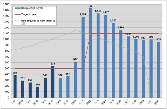
|
Ref. |
Page (LP1) |
Policy / Paragraph |
Modification |
Reason / source |
|
|
(13) MM 375 |
224 |
After paragraph 14.39 (new paragraphs) |
INSERTED:We will also work with these and other relevant authorities to understand, and holistically plan for, any long-term strategic infrastructure requirements arising from future growth. This will include consideration of any infrastructure that may be required within North Hertfordshire to facilitate the delivery of growth proposed in other authorities' plans or other long-term aspirations that may come to fruition over the plan period. Any proposals to expand London Luton Airport beyond the limits of its current planning permission would fall within the scope of this commitment. INSERTED:NHDC will be a co-commissioning authority for the A505 Corridor Study along with Luton Borough Council, Central Bedfordshire Council, Hertfordshire County Council and other neighbouring authorities as appropriate. The outcomes of this Study will determine the likely long-term cumulative traffic impacts of growth in the wider area on both LutonINSERTED: INSERTED:and North Hertfordshire and potential measures to mitigate these. |
For INSERTED:effectiveness following Matter 5 &Matter 6 hearings |
|
|
(1) MM 376 |
224 |
Paragraph 14.40 |
We will continue to engage constructively in DELETED:this process INSERTED:these processes and, if necessary, consider how best to reflect the outcomes. Dependant on the nature of any issues raised, it may be possible to deal with this through partial or focused reviews of any relevant policy/ies. |
Consequential to MM375 for INSERTED:effectiveness |
|
|
Ref. |
Page (LP1) |
Policy / Paragraph |
Modification |
Reason / source |
||||||
|
Policy 25 |
Re-use of rural buildings |
Policy CGB4 |
Existing DELETED:rural buildings INSERTED:in the Rural Area Beyond the Green Belt |
|||||||
|
Policy 29 Rural housing needs |
Policy CGB2INSERTED:a Exception sites DELETED:in rural areas INSERTED:for affordable housing in the Green Belt INSERTED:Policy CGB2b INSERTED:Community facilities, services INSERTED:and affordable hosing in the Rural Area Beyond the Green Belt |
|||||||||
|
Policy 30 |
Replacement or extension of dwellings in the countryside |
Policy CGB4 Policy D2 |
Existing DELETED:rural buildings INSERTED:in the Rural Area Beyond the Green Belt House extensions, replacement dwellings and outbuildings |
|||||||
|
Policy 42 |
Shopping |
Policy SP4 Policy ETC3 |
Town INSERTED:Centres, DELETED:and Local Centres INSERTED:and Community Shops New retail, leisure and other main town centre development |
|||||||
|
229- 230 |
The Local Plan DELETED:Proposals INSERTED:Policies Map includes the following designations, which are set by, and specifically relate to, policies in the Plan:
|
For INSERTED:legal compliance and to ensure the Plan is INSERTED:effective and INSERTED:justified consequent to MM088 |
||||||||
|
Ref. |
Page (LP1) |
Policy / Paragraph |
Modification |
Reason / source |
|||||
The DELETED:Proposals INSERTED:Policies Map also includes the following designations, which although referred to by policies in the Plan, are not the responsibility of the Local Plan and the extents of the designations are not set by the Local Plan process… [remainder of Appendix unchanged] |
|||||||||
|
(1) MM 378 |
243 |
Appendix 4: Car Parking Standards Residential Parking Standards |
For INSERTED:effectiveness following Matter 16 hearing session (ED55, ED153); Consequential to MM120, MM121 and MM122 |
||||||
|
Class Use C3 |
Car Parking Standard |
Minimum Cycle Parking Standard |
|||||||
|
1 bedroom |
1 space per dwelling minimum |
1 secure covered space per dwelling. None if garage or secure area provided within curtilage of dwelling |
|||||||
|
2+ bedrooms |
2 spaces per dwelling minimum |
||||||||
|
INSERTED:Retirement developments (e.g. warden assisted independent living accommodation) |
INSERTED:1 space per dwelling minimum |
INSERTED:1 secure and covered space for residents per 5 units. |
|||||||
|
Ref. |
Page (LP1) |
Policy / Paragraph |
Modification |
Reason / source |
|||||||
|
The above DELETED:standard INSERTED:standards will also require visitor / unallocated parking as set out below to be added. Garages will be counted towards meeting the standards only if they are at least 7m x 3m measured internally. INSERTED:Reductions from these standards will only be considered where applicants can demonstrate that the accessibility, type, scale, mix and use of the development; the availability of and opportunities for public transport; local car ownership levels; and on-street conditions justify such variations. DELETED:Reductions will be considered only in exceptional circumstances e.g. in town centres or other accessible locations with the availability of a range of local services and good local sustainable transport options and for e.g. small-scale conversion of buildings for a small number of residential units in defined town centres. INSERTED:Visitor/Unallocated Parking |
|||||||||||
|
Class Use C3 |
Car Parking Standard |
Minimum Cycle Parking Standard |
|||||||||
|
DELETED:Retirement developments (e.g. warden assisted independent living accommodation) |
DELETED:1 space per dwelling minimum |
DELETED:1 space per 8 units (visitors) |
|||||||||
|
Visitor / unallocated |
Between 0.25 and 0.75 spaces per dwelling (rounded up to nearest whole number) with the INSERTED:higher DELETED:lower standard being applied where there are no garages in the schemes and the INSERTED:lower DELETED:higher standard applied where every dwelling in the scheme is to be provided with a garage |
INSERTED:For above C3 general housing - if no garage or secure area is provided within curtilage of dwelling then 1 covered and secure space per dwelling in a communal area DELETED:for residents plus 1 space per dwelling for visitors INSERTED:For C3 retirement developments - 1 covered and secure visitor space per 3 units |
|||||||||
|
Ref. |
Page (LP1) |
Policy / Paragraph |
Modification |
Reason / source |
|||||
|
For the above DELETED:two INSERTED:visitor and unallocated parking standards, reductions in provision will be considered where:
INSERTED:3. Relevant evidence is submitted by the applicant which supports a reduction in standard and considers existing and future car ownership and likely visitor INSERTED:demand. |
|||||||||
|
(1) MM 379 |
Appendix 5 (new) |
INSERTED:Appendix 5: Letchworth Garden City Design Principles
|
For INSERTED:effectiveness following Matter 17 hearing session and consequential to MM147 |
||||||
|
Ref. |
Page (LP1) |
Policy / Paragraph |
Modification |
Reason / source |
|
|
INSERTED:development in the Garden City is a pre-requisite to the success of any proposals. The following notes are intended to give a guide to examples which might be studied, with benefit.
|
|||||
|
Ref. |
Page (LP1) |
Policy / Paragraph |
Modification |
Reason / source |
|
|
|||||
The Policies Map is not defined in statute as a Development Plan document and the Inspector does not have the powers to recommend Main Modifications to it. However, as a consequence of the proposed Main Modifications set out in the remainder of this schedule or for the general effectiveness of the Plan, it will be necessary to make a number of amendments to the Proposed Submission Policies Maps. These are set out below. Detailed, individual maps are set out in the separate document, Proposed Changes to the Policies Map, which is available as a supporting document to the Main Modifications consultation.
Any comments on the changes to the Policies Map should, where possible, be directed to the relevant Main Modification(s) to the Plan.
|
Ref. |
Policy / Paragraph |
Modification |
|
(1) MM 380 |
Policy SP3 |
Remove Letchworth Power Station as an Employment Site (SP3) and denote and Employment Area (ETC1) |
|
(1) MM 381 |
Policy SP8 |
Amend legend for Letchworth Garden City Town Centre Boundary to identify that this also represents the 'broad location' for housing identified under Policy SP8 |
|
Policy SP18 |
Include access route to allocation from Mendip Way |
|
|
Policy ETC1 |
Remove Business Areas annotation but retain underlying Employment Area status. |
|
|
Housing allocation WY1 / Urban Open Land |
Amend alignment of housing allocation / urban open land boundary in line with Statement of Common Ground |
|
|
Policy HS7 |
Add additional Gypsy & Traveller allocation at Danesbury Park Road (CD6) |
|
|
(2) MM 386 |
Housing allocation BA2 / Green Belt boundary, Baldock |
Amend allocation boundary to reflect land-ownership and defensible features |
|
Ref. |
Policy / Paragraph |
Modification |
|
(8) MM 387 |
Housing allocations BA3 & BA4 |
Amend boundaries between sites and extend BA3 to incorporate 'white land' |
|
Housing allocation BK2 |
Reduce housing allocation to exclude open space |
|
|
Housing allocation BK3 |
Enlarge to housing allocation to include reserve school site |
|
|
(1) MM 411 |
Housing allocation HT2 |
Changed to omit small area of neighbouring property |
|
Housing allocation HT8 |
Reduce to reflect extent of land remaining for potential development |
|
|
(1) MM 391 |
Settlement boundary - Hitchin |
Remove land east of Bedford Road that is not part of The Priory School |
|
Housing allocation RY5 |
Delete as allocation has been implemented |
|
|
Settlement boundary - Offley |
Amend south east boundary of settlement to reflect curtilage boundary. |
|
|
Settlement boundary – Therfield |
Amend the boundary around the southeast of the settlement (Hay Green) to more tightly follow the limit of existing development. |
|
|
Settlement boundary – Whitwell |
Amend the settlement boundary in relation to Policy SP2 (Whitwell) to exclude the recreation ground to the south of the settlement |
|
|
Housing allocation SI1 |
Extend the site boundary to abut London Road |
Annex 1: Key Diagram (MM007)
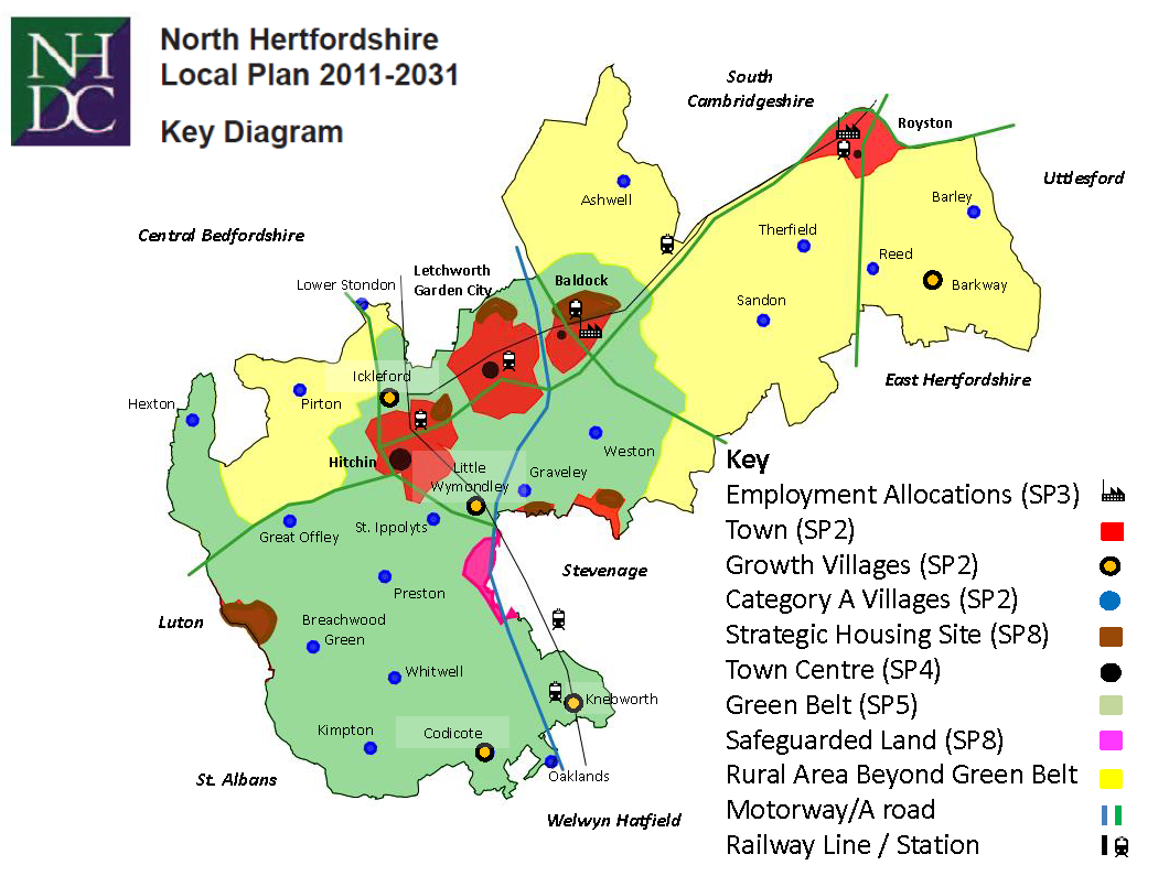
ED2 Markides Associates technical note on transportation East of Luton
ED3 Partial update on housing monitoring and 5 year supply
ED4 Luton Local Plan Inspector's report
ED5 MoU between NHDC and Greater Cambridge & Greater Peterborough Local Enterprise Partnership
ED6 SoCG between NHDC and Aylesbury Vale District Council
ED7 SoCG between NHDC and St Albans District Council
ED13 MoU between NHDC and East Herts District Council
(2) ED14 NHDC Transport Strategy
(1) ED14A Errata attached to ED14 NHDC Transport Strategy
ED16 Inspector's final report on Stevenage Borough Council Local Plan
ED17 PSE Consulting: review of smaller scale (4-5FE) versus larger (6FE) Secondary Schools
ED18 Updated SoCG on NHDC Local Plan between NHDC and Luton Borough Council
ED19 Interpretation of COMET Model results for North Hertfordshire District
ED20 Hitchin Industrial Area Transport Study
(1) ED21 ED53 - Matter 1 NHDC Opening Statement at Hearing Sessions: Cllr Levett
ED22 Mr Marcus Powell: Details of FOI request
ED25 ED53 - Matter 3 HMA's Bedfordshire and the surrounding areas: Updating the evidence of Migration
ED27 SoCG between NHDC and HCC: Strategic Allocation BA1
ED28 SoCG between NHDC, Bloor Homes and The Crown Estate: Strategic Allocations EL1, EL2 and EL3
ED29 SoCG between NHDC and Picture SRL: Strategic Allocation GA2
ED30 SoCG between NHDC and Bellcross Homes: Strategic Allocation HT1
ED31 SoCG between NHDC and Letchworth Garden City Heritage Foundation: Strategic Allocation LG1
ED32 SoCG between NHDC and Croudace Homes: Strategic Allocation NS1
ED34 Calverton Judgement: Case No: CO/4846/2014
ED35 Secretary of State's speech on Housing Market
ED36 Secretary of State's letter to Stevenage Borough Council re hold on Local Plan
ED37 ED53 - Matter 2 NHDC Proposed Revisions to Policy SP2
ED39 ED53 - Matter 2 NHDC response to Mr Powell's FOI
ED39a: Freedom of Information response
ED39b: Appeal decision: APP/X1925/W/17/3172798 Rose Farm, Codicote Road, Whitwell, Herts SG4 8AB
ED41 NHDC: CAG response to ED40
ED42 ED53 - Matter 4 NHDC Note to Inspector: Five Year Housing Land supply scenarios
ED43 ED53 - Matter 1 NHDC Note to Inspector re operation of website during consultations especially regulation 19 consultation
ED44 ED53 - Matter 2 NHDC current and proposed Green Belt Maps
ED44a: Current Green Belt Boundaries
ED44b: Proposed Green Belt Boundaries
ED50 SoCG between NHDC and New Road Property Developments & Bovis Homes WY1 Land South of Little Wymondley and Policy CGB5
ED51 SoCG between NHDC and Letchworth Garden City Heritage Foundation
ED52 ED53 - Matter 1 SoCG between NHDC and Natural England
ED57a ED53 - Matter 3 St Modwen Developments V Secretary of State 28.4.16 CO/3653/2015
ED57b ED53 - Matter 3 St Modwen Developments: Court of Appeal C1/2016/2001
ED58a ED53 - Matter 3 Oadby & Wigston BC V Secretary of State & Bloor Homes 3.7.15 CO/1359/2015
ED58b ED53 - Matter 3 Oadby & Wigston BC: Court of Appeal C1/2015/2447
ED59 Dartford Borough Council V Secretary of State Court of Appeal CO/4129/2015 Case No: C1/2016/1664
ED60 NHDC Gypsy & Traveller Accommodation Assessment Update Final Report
ED61 Letter from NHDC Property Services concerning sites in the Local Plan
(6) ED62 NHDC Note to Inspector on Air Quality
ED63 AQMA Action Plan Stevenage Road - Hitchin
ED64 AQMA Action Plan Stevenage Road and Paynes Park, Hitchin
ED65 AQMA Action Plan non technical summary Stevenage Road & Paynes Park
ED66 AQMA Action Plan update Stevenage Road, Hitchin
ED67 AQMA Order Paynes Park, Hitchin
ED68 AQMA Order Stevenage Road, Hitchin
(6) ED69 NHDC Air Quality Annual Statistics Report 2016
(6) ED70 NHDC Air Quality Annual Statistics Report 2017
ED71 Statement of Common Ground between NHDC and landowners West of Stevenage re safeguarded land
ED73 ED53 - Matter 4 Infrastructure Delivery Plan (main report)
ED73A Appendix 1 - Infrastructure Delivery Schedule
ED74 NHDC Matter 6 Infrastructure Table
ED75 Supplementary SoCG with LGCHF
ED76 Lower Stondon Heritage Assessment
ED77 ED53 Matter 4 NHDC Liaison with Letchworth Garden City Heritage foundation re NHDC proposed development in Letchworth Town centre
ED78 ED53 Matter 4 NHDC calculation re 20% figure in policy SP8(d) re previously developed land
ED79 ED54 Matter 7 NHDC to provide justification for proposed addition of land to Green Belt
ED80 SOCG between NHDC and EW Pepper Ltd re: education provision at site RY1, Royston
ED81 SOCG between NHDC and Bloor Homes/The Crown Estate re: education provision at strategic site EL1/2/3, East of Luton
ED82 SOCG between NHDC and Historic England
ED83 ED54 Matter 8 NHDC note on self build
ED84 ED54 Matter 9 NHDC note on SHLAA chronology
ED85 ED53 - Matter 6 NHDC Note on transport modelling and the southern bypass for Hitchin
ED86 ED53 - Matter 6 NHDC - Note on the B656 between Codicote and Knebworth
ED89 NHDC Note on Chilterns AONB Proposed Extension (Matter 19)
ED90 SoCG between NHDC and Hertfordshire County Council re: BA1
ED91 SoCG between NHDC and Hertfordshire County Council re: BA2, BA3 and BA4
ED93 ED55 - Matter 19 - previous consultation responses from HRBC Herts Ecology
(6) ED97 Luton Borough Council 2015 transport modelling evidence re Luton Airport
ED105 ED53: Matter 6 Statement of common ground between NHDC and Hertfordshire County Council Highways
ED106 Supplementary SoCG between NHDC and Picture SRL re allocation GA2 Land NE of Stevenage
ED107 Supplementary SoCG between NHDC and Croudace re allocation NS1 Land North of Stevenage
ED108 SoCG between NHDC and Gladman Developments Ltd re Site KB4
ED109 ED53 - Matter 1: Missing correspondence between NHDC & HCC in relation to education matters
ED110 ED54: NHDC to confirm to Ms Cheryl Peers the number of the sites allocated in the draft LP which are in the GB as currently defined
ED110A Appendix A: List of sites in GB as currently defined
ED112 Supplementary SoCG between NHDC and New Rd. Property Developments and Bovis Homes: WY1 Land south of Lt. Wymondley and Policy CGB5
ED113 ED94: Matter 21 response to Ms Cottier re access to website between 31.12.17 and 23.1.18
ED114 SoCG Between NHDC and Mr Neil Ross site TH1
ED116 ED96: Matter 11 English Heritage representation to the Preferred Options consultation February 2015
ED117 ED56: Matter 14 Council response to Inspector's queries re: retail issues
ED118 ED56: Matter 13 Council's responses to Inspector's queries re: Economic Development (B class uses)
ED121 Chilterns AONB Setting Report
ED131 Supplementary Statement of Common Ground between NHDC and Bellcross Homes re. Site HT1: Highover Farm, Hitchin
ED136 NHDC note to the Inspector on services & features at AS1
(10) ED159 NHDC note to Inspector: Implications of new household projections for the NHDC Local Plan
(31) ED161A Green Belt Review Update
(31) ED161B Green Belt Review Update - Appendices
ED163 Council's annotated response to the Inspector's note (ED160A)
ED164 Updated Habitat Regulation Assessment
ED164A Updated Habitat Regulation Assessment - Appendix 5
(2) ED137 Matter 1: Legal Requirements
ED138 Matter 2: Sustainable Development: the settlement hierarchy
ED139 Matter 3: The Housing Strategy: the need for housing and the housing requirement
(21) ED140 Matter 4: The Housing Strategy: the supply of land for housing
ED141 Matter 5: Housing Strategy: The spatial distribution of new housing.
ED142 Matter 6: Deliverability
(12) ED143 Matter 7: Countryside and Green Belt: the Green Belt review and approach to safeguarded land
ED144 Matter 8: The Housing Strategy: affordable housing, housing mix and supported, sheltered older persons housing
ED145 Matter 9: Housing Strategy: the spatial distribution of new housing
ED146 Matter 10: The housing allocations and the settlement boundaries: The Towns
(1) ED146B Letchworth and Royston
ED147 Matter 10/11: Stevenage (Gt Ashby), Graveley (including North of Stevenage) and Knebworth.
ED148 Matter 11: The housing allocations and the settlement boundaries: The Villages
ED148A Ashwell, Barkway, Barley, Breachwood Green, Hexton and Kimpton
ED148B Ickleford, Lower Stondon, Little Wymondley and Codicote
ED148C St Ippolyts, Reed, Sandon, Therfield, Weston, Whitwell, Oaklands, Offley, Pirton and Preston
(1) ED149 Matter 12: Provision for Gypsies, Travellers and Travelling Showpeople
ED150 Matter 13: Economic Development
ED151 Matter 14: Town and Local Centres
ED152 Matter 15: Countryside and Green Belt: the policy approach to the Green Belt, Rural Areas beyond and the Green Belt and Urban Open Land
ED153 Matter 16: Transport and Infrastructure
(1) ED154 Matter 17: Design including Air Quality (also see ED156 Matter 21 Air Quality)
ED155 Matter 18: Healthy communities
ED156 Matter19: The Natural Environment
ED157 Matter 20: The Historic Environment
(2) ED158 Matter 21: Air quality (see also ED152 Matter 17 Design including air quality).
(47) ED159 - NHDC Note: Implications of new household projections