Wallington Neighbourhood Plan 2022 - 2031 Submission Version June 2023
7 Countryside and green space
Policy W8: Green and blue Infrastructure, landscape features and biodiversity
Purpose
7.1 This policy seeks to ensure that the key features that contribute to the natural character of the area and which provide habitats and wildlife corridors, are not adversely impacted by development, rather they are, where possible, enhanced by it.
Justification
7.2 The NPPF states that plans should seek to protect and enhance biodiversity and geodiversity including by identifying and mapping habitats and networks.
The Defra biodiversity metric
has been designed to determine and quantify existing biodiversity value, in terms of habitats, and the consequent measures required to ensure measurable net gain. Net gain involves a post development increase in biodiversity units of 10%. Natural England considers this to be the most appropriate mechanism for determining current ecological value and delivering biodiversity net gain. Ecological assessment by suitably qualified people must utilise this metric on all habitats to determine net gain. Ecological reports must be consistent with BS 42020 Biodiversity – code of practise for planning and development.
7.3 The WNP Working Group commissioned the Herts Environmental Records Centre (HERC) to prepare a report on the habitats and species found within the neighbourhood area. Much of the report is confidential due to the nature of the content. The HERC should be consulted on any development proposals This revealed the following designated habitats:
- Ancient woodland: Bury Wood; Coles Wood; and Spital Wood/Bush Spring
- Local Wildlife Sites: Icknield Way, SW of Slip End (A505); Bush Spring, Clothall; Spital Wood and Prim Spring; Bury Wood; Wallington Churchyard; Wallington Common and Coles Wood; Copse E. of Prim Spring; Copses S. of Bury Wood; and Manor Farm.
- Local Green Spaces: as defined in Policy W9
- Significant trees and blue spaces as identified in the Conservation Area Appraisal
7.4 In addition, the Local Biodiversity Action Plan for Hertfordshire, prepared by the Herts & Middlesex Wildlife Trust, identifies Key Biodiversity Areas in the county, one of which falls within the neighbourhood plan area, the Clothall/Wallington/Weston area of chalky boulder clay woods and meadows. Key species in this area include arable weeds (Shepherd's Needle, Corn Gromwell) and birds (Quail, Corn Bunting, Stone Curlew, Golden Plover, Dotterel, Turtle Dove, Skylark).
7.5 In addition to these designated habitats, there are other distinctive natural features particular to Wallington that are not protected yet provide vital habitats for flora and fauna. The area is home to trees and woodland, including ancient woodland and significant trees within the conservation area. As noted in the NPPF at paragraph 131, trees play a vital part in dealing with the effects of climate change and managing pollution. They provide shade, reduce flood risk, enable carbon capture, improve air quality and contribute to the purification of water. They also contribute to local character.
7.6 Ancient woodland is an irreplaceable habitat, which has both heritage and cultural value. Natural England advises that development which would result in the loss of, or damage to, ancient woodland will not be permitted except in wholly exceptional circumstances, as set out in paragraph 180 of the NPPF. They advise that it is preferable to link up fragmented areas of woodland, which might be divided by development, with green bridges or tunnels. Also, to buffer ancient woodland by leaving an appropriate zone of semi-natural habitat between the development and the woodland, providing wildlife corridors, and balancing new developments and residential areas with green infrastructure and allowing space for trees.
7.7 Other natural features include hedgerows, mature planted gardens, agricultural and grazing land, ponds and meadows. The Conservation Area Appraisal identifies significant green and blue spaces, some of which are also designated as Local Green Spaces. These provide individually and collectively vital steppingstones and corridors for many animals and birds, especially those migrating, to safely navigate around their domains. The HERC report identified 632 distinct plant and animal species in the area, including protected ones such as the grey partridge, hawfinch, yellowhammer, Eurasian badger, and the brown long-eared bat.
7.8 The green and blue infrastructure assets of the area should be maintained, enhanced and, where possible, better connected. If significant harm resulting from a development cannot be avoided (for instance by locating to an alternative site with less harmful impacts), adequately mitigated, or, as a last resort, compensated for, then planning permission should be refused.
7.9 Planning permission should also be refused for any development resulting in the loss or deterioration of irreplaceable habitats such as veteran trees and trees of a high conservation value, unless the need for and benefits of the development in that location clearly outweigh the loss. In this instance, substantial compensation as quantified by the Defra biodiversity metric will be required.
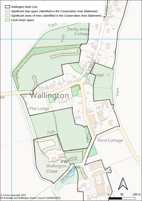
Figure 7.1: Important natural features in the village
(2) POLICY W8: GREEN AND BLUE INFRASTRUCTURE LANDSCAPE FEATURES AND BIODIVERSITY
- Development will be expected to retain well-established features of the landscape, including ancient woodland, significant trees, species-rich hedgerows and ponds.
- Proposals should be designed to create, conserve, enhance and manage green spaces and connect chains of green infrastructure, as identified in Figure 7.1, with the aim of delivering a measurable net environmental benefit for local people and wildlife. Proposals for development must be supported by a biodiversity appraisal, which must demonstrate how negative impacts would be minimised and biodiversity net gain achieved.
- The appraisal should demonstrate that where significant harm cannot be avoided, proposed development and other changes should adequately mitigate or, as a last resort, compensate for the harm. The appraisal should seek to demonstrate a measurable biodiversity net gain of a minimum of 10% by utilising the Defra biodiversity metric (or as amended). Where this is not demonstrated, permission for planning or for change should be refused.
- Measures to achieve biodiversity net gain, mitigation or compensation involving the creation of habitat and/or relocation of species, must be agreed by the Local Planning Authority and include sufficient funding to support at least 30 years of post-development habitat management or land use change.
- Proposals that seek to improve the connectivity between wildlife areas and green spaces will be encouraged to enhance the green infrastructure of the Neighbourhood area. Conversely, proposals which threaten to damage such connectivity will be strongly resisted.
Conformity reference: NP Objective: 1; Local Plan: SP10, SP12; NPPF: 174, 175, 179, 180
Policy W9: Local Green Spaces
Purpose
7.10 This policy designates 13 sites that are demonstrably special to the local community, as Local Green Spaces. This will safeguard them against inappropriate development.
Justification
7.11 Under the NPPF, neighbourhood plans have the opportunity to designate Local Green Spaces which are of particular importance to the local community. This will afford protection from development other than in very special circumstances. Paragraph 102 of the NPPF says that Local Green Spaces should only be designated:
- "where the green space is in reasonably close proximity to the community it serves;
- where the green area is demonstrably special to a local community and holds a particular local significance, for example because of its beauty, historic significance, recreational value (including as a playing field), tranquillity or richness of its wildlife; and
- where the green area concerned is local in character and is not an extensive tract of land."
7.12 Planning practice guidance states the following in relation to Local Green Spaces:
- A Local Green Space does not need to be in public ownership.
- If land is already protected by Green Belt policy, then consideration should be given to whether any additional local benefit would be gained by designation as Local Green Space. One potential benefit in areas where protection from development is the norm (eg villages included in the green belt) but where there could be exceptions is that the Local Green Space designation could help to identify areas that are of particular importance to the local community.
- Some areas that may be considered for designation as Local Green Space may already have largely unrestricted public access, though even in places like parks there may be some restrictions. However, other land could be considered for designation even if there is no public access (eg green areas which are valued because of their wildlife, historic significance and/or beauty). Designation does not in itself confer any rights of public access over what exists at present. Any additional access would be a matter for separate negotiation with land owners, whose legal rights must be respected.
7.13 When designating Local Green Spaces, it is important to consider what protection is already afforded to an area and whether or not the designation will provide any further safeguard.
7.14 The engagement process revealed a series of green spaces that the community wishes to safeguard. The Working Group examined each of these to understand whether they were already adequately protected and, where this was not the case, to what extent they met the NPPF criteria.
7.15 The following 13 spaces, which are mapped in Figure 7.2, have been identified for designation, with detail on how they meet the NPPF criteria contained in Appendix F:
- Mutcheaps Field
- The Chase Meadow
- Village Hall playground
- The Wick
- The Park
- Plough Paddock
- St Mary's Wallington Churchyard
- Kitt's Piece
- Wallington Village Pond
- The Well Pond and surrounding area, including the Church bankside opposite
- Carter's/ Parsons Pond
- The Spinney
- The Common
(3) POLICY W9: LOCAL GREEN SPACES
The following 13 spaces, as shown on Figures 7.2 and 7.3, are designated as Local Green Spaces:
- Mutcheaps Field
- The Chase Meadow
- Village Hall playground
- The Wick
- The Park
- Plough Paddock
- St Mary's Wallington Churchyard
- Kitt's Piece
- Wallington Village Pond
- The Well Pond and surrounding area, including the Church bankside opposite
- Carter's/ Parsons Pond
- The Spinney
- The Common
Inappropriate development will not be supported except in very special circumstances.
Conformity reference: NP Objective: 1, 3; Local Plan: SP12; NPPF: 101-103, 147-151
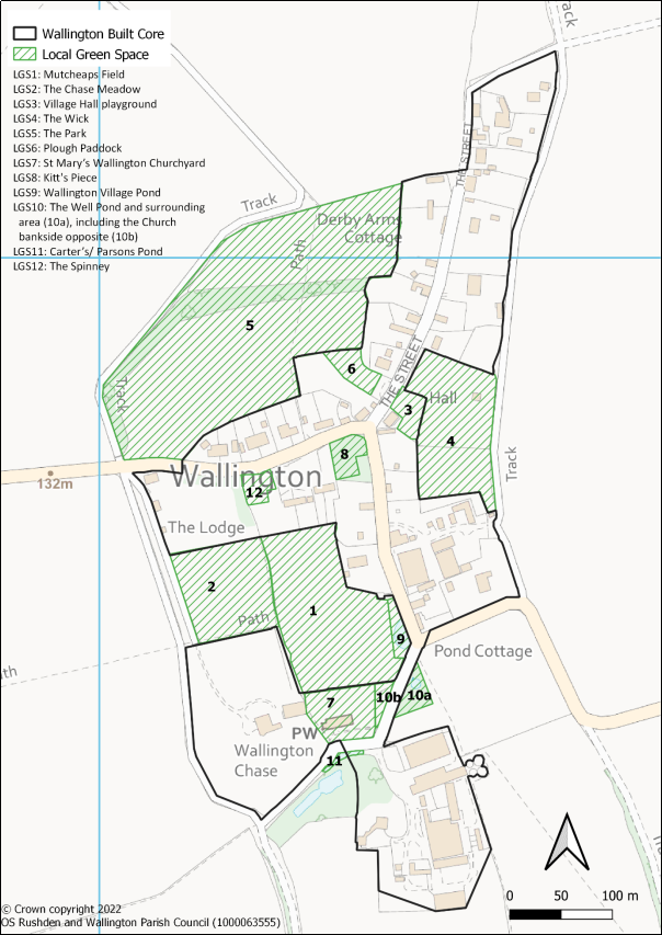
Figure 7.2: Local Green Spaces (LGS1 to LGS12)
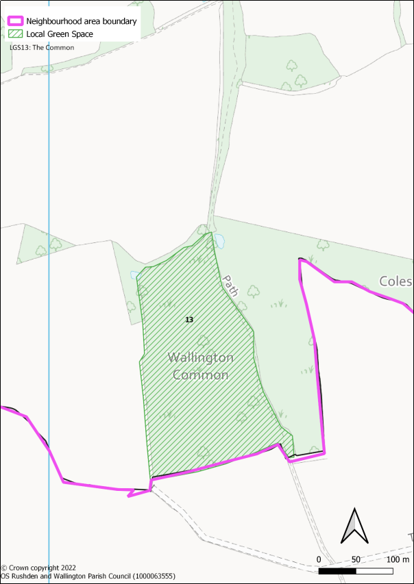
Figure 7.3: Local Green Spaces (LGS13)