Wallington Neighbourhood Plan 2022 - 2031 Submission Version June 2023
(1) 6 Design, character and Heritage
Policy W4: Reinforcing Wallington's local character through design
Purpose
6.1. This policy promotes high quality design that is in keeping with, and contributes positively towards, the character of the area. It adds additional local detail to the strategic policies contained within the NHDC Local Plan.
Justification
6.2. Both the underlying geology and landscape, coupled with the activities of past generations of people and development, have created the features that give the Wallington its distinctive character and identity today.
6.3. From a landscape perspective, the Wallington Scarp slopes Landscape Character Area (Area 233, p. 414) forms an important natural feature to the north and east. This open, unenclosed landscape affords sweeping views over the striking rolling backdrop. It and has been used within numerous films seeking a remote and development-free setting. The land is predominantly arable in nature, providing a habitat for a variety of animals including hares and numerous farmland birds, such as corn-bunting and quail. The openness of the landscape means that development can be very conspicuous and therefore should be carefully thought out.
6.4. The remainder of the area, to the south, falls within the Weston-Green End Plateau Landscape Character Area (Area 222, p.136). This flat, gently sloping plateau, comprises arable land, pockets of woodland, hedgerows, and winding roads. There are a number of important green spaces within the village that contribute to this landscape, as shown on the Policies Map, along with other character features within the area.
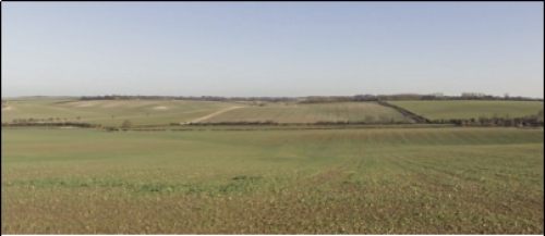
Sweeping open views are typical of the area
6.5. The historic settlement pattern is of a sparse nature characterised by farms and the small village of Wallington itself. There are a few minor roads and a small number of rights of way, however, despite its proximity to the A1, Wallington is characterised by its rural, tranquil nature and is quite hidden amid the wider landscape. The village is almost entirely designated as a Conservation Area, with 19 individual and collections of listed buildings (almost a third of the village), the Church of St Mary being Grade II* listed with parts dating from the mid-15th century (see Figure 6.1). Archaeological deposits have been found in the area, including Bronze Age and Neolithic Flint near to the Church, while to the north, finds have included prehistoric ring ditches and Roman-British burials.
6.6. The village is perhaps most well-known for being the home of George Orwell between 1936 and 1940, and for providing the inspiration for Animal Farm, in particular The Great Barn and Manor Farm, the latter being the name of the farm in the village. These features are greatly valued, with one response to the community survey stating: "We have a responsibility to protect the literary heritage of George Orwell's Animal Farm by ensuring any development is a good fit for the original appearance of the farmyard." The attractive design and architecture of developments within the village is typical of Hertfordshire, making use local traditional materials such as clay roof tiles and timber weatherboarding.
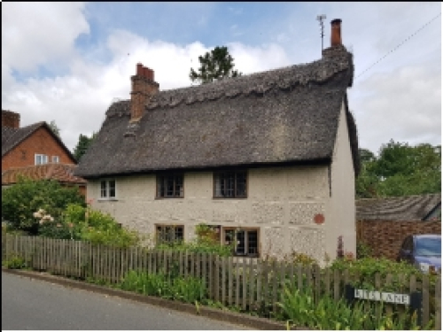
George Orwell's former residence, Kit's Lane
6.7. The Wallington Design Guidelines and Codes (included at Appendix C) forms an integral part of the WNP. It sets out design guidance to inform planning applications and residential developments in the Neighbourhood Plan area. It provides guidance for infill development and conversions explaining how these should be designed to reinforce the local historic character of the area and to preserve the open space, which is characteristic of Wallington. The guidance complements the Wallington Conservation Area Character Statement, published in 2019, which sets out opportunities for improvement within the Conservation Area that should be considered within development proposals.
6.8. All development should be designed to a high quality and reinforce and enhance local character, heritage assets and the rural setting of the area, including its dark skies. Residents are encouraged to turn lights off at nightfall.
6.9. The density of development should create a character that is appropriate to the site's context, including the landscape in which it is set, whilst making best use of the land available. Lower density housing should be located towards the outer edges of the settlement where it abuts open countryside, to maintain views from and into the individual settlements.
6.10. The Housing our Ageing Population Panel for Innovation (HAPPI) has, since 2009, promoted a series of principles for good design of housing. Many are recognisable from good design generally - good light, ventilation, room to move around and good storage - but they have particular relevance to the spectrum of older persons' housing which needs to offer both an attractive alternative to the family home and be able to adapt over time to meet changing needs. Such principles should be incorporated.
6.11. Development should have regard to both the character of the area in which it is set and to the character of the area overall.
6.12. Car parking also needs to be carefully considered; the historic nature of the village has meant that some houses do not have off-street parking. Vehicles often park on-street, therefore, which can be problematic given the narrowness of the streets. NHDC's Parking standards do not require visitor parking to be off-street, therefore this is something that the WNP seeks to address.
(3) POLICY W4: REINFORCING WALLINGTON'S LOCAL CHARACTER THROUGH DESIGN
- Development is expected to preserve and enhance the local character of Wallington. The design of new development should take account of the local context and reflect the natural and built character and vernacular of the area, in terms of architecture and materials, to avoid building design that is inappropriate to the Plan area. Careful consideration should be given to the impact of the development on the openness of the landscape. Innovation in design will be supported, however, only where this demonstrably enhances the quality of the built form in the area.
- As appropriate to their scale, nature and location development proposals should address the following criteria:
- be guided by the principles included in the Wallington Design Guidance and Codes (2021) (see Appendix C), the Wallington Conservation Area Character Statement (2019) and the North Hertfordshire and Stevenage Landscape Character Assessment; and
- meeting the principles of Building for a Healthy Life unless alternative principles would result in a higher quality of design. Development proposals that would achieve the Building for a Healthy Life commendation will be particularly supported; and
- site masterplanning and site layouts should reflect historic character as well as appearance; and
- for residential development, addressing the principles of Housing our Ageing Population Panel for Innovation (HAPPI). Such dwellings may also be suitable for younger residents and are not intended to be restricted to particular users; and
- minimise its impact on both designated and non-designated heritage assets, in accordance with Policy W5; and
- follow the guidance on lighting provided in the Institution of Lighting Professionals (ILP) Guidance Note GN01: The Reduction of Obtrusive Light (and any subsequent revisions) is adhered to. Proposals should consider carefully, and provide details of, the light source and intensity being used, the luminaire design, height, and angle, adding baffles and cut-off shields where required, and details of control mechanisms to dim or switch off lighting schemes when not required. Where appropriate, lights should be controlled by passive infrared detectors so that they only come on when needed.
- avoid significant detrimental impact on the local views as set out in Policy W7; and
- make a positive contribution to the visual appearance of the main highway approaches into the settlements: Wallington Road and The Street, which should include adding tree planting or the provision of roadside green verges; and
- ensure safe pedestrian, and where feasible cycle/equestrian, access to link up with the existing Public Rights of Way network; and
- ensure that traffic generation and parking does not adversely affect vehicular and pedestrian safety. The use of sustainable transport modes should be promoted by providing space for cycle parking, improving Public Rights of Way infrastructure and provision of electric vehicle charging points. Residential parking provision should be in accordance with the NHDC Parking standards, with priority given to adequate off-road parking for residents, visitors and service vehicles; and
- ensure that areas requiring service and maintenance including watercourses are accessible at all times.
- be guided by the principles included in the Wallington Design Guidance and Codes (2021) (see Appendix C), the Wallington Conservation Area Character Statement (2019) and the North Hertfordshire and Stevenage Landscape Character Assessment; and
Conformity reference: NP Objective: 1, 2; Local Plan: SP6, SP9, SP12, SP13; NPPF: 92, 100, 1004e, 106, 107, 124-132, 174
Policy W5: Heritage Assets in Wallington
Purpose
6.13. This policy identifies heritage assets within the neighbourhood area that are neither nationally nor locally listed, but which are locally important, as non-designated heritage assets. It also seeks to conserve the rich archaeology of the area.
Justification
6.14. Wallington has a rich heritage with 19 individual and collections of nationally important heritage assets that are designated by way of a listing. These account for approximately one third of the village's buildings and structures.
6.15. The Conservation Area Character Statement for Wallington identified two assets that are not currently nationally listed but which were considered to contribute to the heritage and character of Wallington:
- 11 – 13 The Street: A red brick estate cottage with hood mould above the windows to the north of the former Plough Public House. The hood moulding is shared by 4-6 Kit's Lane and the Village Hall.
- The Old Post Office on The Street.
6.16. The Working Group consider that the first, 11-13 The Street, is important from a historical perspective and should be recognised as a non designated heritage asset. Whilst the Old Post Office is an old building, it has been significantly altered and therefore is not considered suitable for identification as a non designated heritage asset.
6.17. Furthermore, as part of the engagement process for the WNP, the local community was asked about whether there were any other assets within Wallington that they considered to be historically important due to the contribution that they make to the distinctive local character and history of the area. Most of the suggestions made were, in fact, already listed, such as Orwell's former residence, various barns at Manor Farm, the phone box and The Plough Inn. The notable assets that are not currently listed are:
- Village Hall
- Village bus shelter
- Well Pond structure
- Village Pump
6.18. Policy W5 identifies five buildings and structures as non-designated heritage assets, in order that their historic contribution is recognised and considered as part of any future development proposal. Full details about why they are of local historic importance is included in Appendix D. Figure 6.1 shows the assets on a map.
6.19. There will be a strong presumption against the loss of these assets and, in parallel with the policy, the Parish Council will seek to include them on NHDC's Register of Buildings of Local Interest. It should be noted, however that inclusion on the Register is not necessary for the application of the policy.
6.20. The area is rich in archaeology, and this has been catalogued in an extensive report (Hertfordshire County Council Monument Full Report (16.3.21) and List of finds from Wallington registered with the Portable Antiquities Scheme: both available in the evidence base on the Parish Council website).
6.21. Policy W5 seeks to ensure that any development proposals consider fully the impact on both above and below ground archaeological deposits. A Heritage Statement is considered appropriate if a planning application seeks permission for a proposed development affecting a heritage asset or its setting; this would include applications for:
- a development to a Listed building or NHDA;
- a development in the setting/adjacent to a listed building or NHDA;
- a development to properties (Inc. outline) in a conservation area;
- a development in the setting of, or adjacent to, a conservation area; and
- wider countryside location where likely to be archaeological deposits.
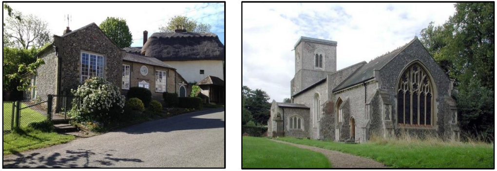
Images show: Wallington Village Hall and Grade II* listed St Mary's Church
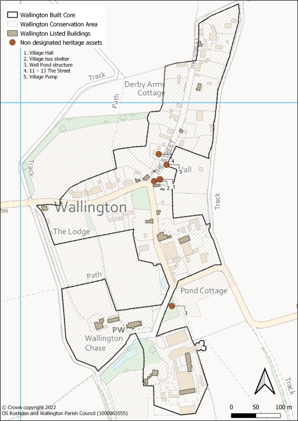
Figure 6.1: Designated and non-designated heritage assets
(1) POLICY W5: HERITAGE ASSETS IN WALLINGTON
- The Neighbourhood Plan identifies the following five buildings and structures (as detailed in Appendix D) as a non-designated heritage assets:
- Village Hall
- Village bus shelter
- Well Pond structure
- 11 – 13 The Street
- Village Pump
- Development proposals affecting heritage assets – including the non-designated heritage assets - either directly or indirectly, should enhance the significance and setting of the asset. This could include, where appropriate, the delivery of development that will make a positive contribution to, or better reveal the significance of, the heritage asset, or reflect and enhance local character and distinctiveness with particular regard given to the prevailing styles of design and use of materials in a local area. Proposals are expected to be accompanied by a Heritage Statement.
- Development proposals should demonstrate that they have taken into account the potential impact on above and below ground archaeological deposits to ensure that evidence which could contribute to the understanding of human activity and past environments is not lost. Where a scheme has a potential impact on archaeological remains (below or above ground) a Heritage Statement or similar should be prepared in support of planning applications.
Conformity reference: NP Objective: 2; Local Plan: SP13; NPPF: 189, 190, 192, 194, 196, 199, 200 to 203, 206
Policy W6: Design to mitigate climate change
Purpose
6.22. This policy encourages high standards of energy efficiency and design. It does so within the broader UK context of achieving a net zero carbon target by 2050.
Justification
6.23. On 12 June 2019 the Government voted to amend the Climate Change Act 2008 by introducing a new target for at least a 100% reduction of greenhouse gas emissions (compared to 1990 levels) in the UK by 2050. This is otherwise known as a net zero target. This is a demanding target, which will require everyone to be engaged, from households and communities, to businesses and local and national government. As part of this, the government has set an interim target to cut the country's greenhouse gas emissions by 78% by 2035 compared to 1990 levels.
6.24. Being '2050 ready' will require new builds to have minimal energy use and net zero carbon emissions over the year. To enable this, the Future Homes Standard coming into force in 2025 should ensure that all new homes built from 2025 will produce 75-80% less carbon emissions than homes delivered under current regulations.
6.25. Planners and developers are strongly encouraged to make use of energy efficient materials and to consider high-efficiency alternative systems and facilities for development sites. In this context, the orientation of buildings can be important to make best use of available sunlight.
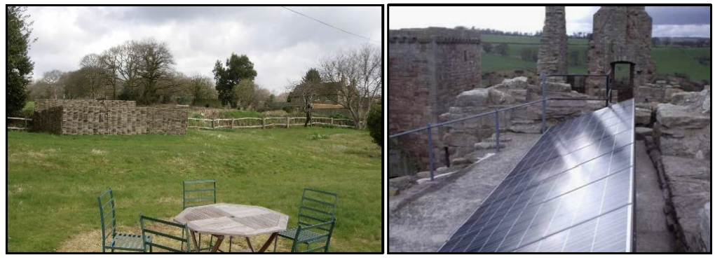
Examples of discreet solar panels (source: Historic England)
6.26. The efficient use of water is also to be considered. The Environment Agency has warned that within the next 25 years and beyond, there may not be enough water due to climate change, population growth and increases in demand. It suggests that local and neighbourhood plans in severely water stressed areas should include targets limiting domestic water consumption. Affinity Water, which serves the area, has already committed to reducing the amount of water it takes from the environment by 78 million litres per day by 2025. To support this, the WNP strongly supports proposals for achieving total mains water consumption of no more than 110 litres per person per day (Each person uses about 142 litres of water each day. The average household (2.52 people) uses 349 litres of water each day. The average annual metered water bill is £4272. per household per year: Energy Saving Trust). This target is equivalent to that proposed as an optional requirement of the Housing Standards Review which corresponds with Code Level 4 in relation to water efficiency.
6.27. Opportunities to promote sustainability and climate mitigation in Wallington include:
- using materials that optimise insulation, to Passivhaus or equivalent standards;
- integrating renewable energy systems into new development and enabling the retrofitting of existing, older buildings;
- reducing water consumption for instance through rainwater harvesting or grey water systems; and
- encouraging a shift to more sustainable and active travel by linking development to and improving the Public Rights of Way and cycleway network, and providing electric vehicle charging points;
6.28. Policy W6 seeks to provide a local iteration of the national and local policy context for this important matter. While taking account of the importance of the Building Regulations in regulating and delivering energy efficiency measures, it identifies a series of locally distinctive design features which would be supported where they are incorporated into development.
(1) POLICY W6: DESIGN TO MITIGATE CLIMATE CHANGE
- Proposals which incorporate design and environmental performance measures and standards to reduce energy consumption and climate effects will be supported.
- Proposals which incorporate the following sustainable design features, as appropriate to their scale, nature and location, will be strongly supported:
- Siting and orientation to optimise passive solar gain, either through the provision of solar photovoltaic cells as part of development or by ensuring that development is designed to maximise the potential for solar gain if retrofitted at a later date. Efforts should be taken to integrate such equipment neatly into the design of the building.
- The use of high quality, thermally efficient building materials, particularly those that are used to achieve the Passivhaus or equivalent standard.
- Incorporating on-site energy generation from renewable sources such as solar panels.
- incorporating energy-efficient heating equipment powered from renewable energy such as air source and ground source heat pumps.
- Reducing water consumption through the use of grey water systems.
- Providing low carbon sustainable design and avoid or mitigate all regulated emissions using a combination of on-site energy efficiency measures (such as insulation and low energy heating systems), on-site zero carbon technologies (such as solar panels) and only where necessary off-site measures to deal with any remaining emissions.
- Providing the infrastructure for adequate electric vehicle charging points for each dwelling in accordance with NHDC Parking Guidance, where new parking provision is expected to be made.
- Alterations to existing buildings should be designed with energy reduction in mind and comply with current sustainable design and construction standards.
- The retrofitting of heritage properties/assets to reduce energy demand and to generate renewable energy will be supported where appropriate, providing it safeguards the integrity and character of the heritage asset concerned.
- Proposals for individual and community scale energy, for instance from hydro-electricity, solar photovoltaic panels, local biomass facilities, anaerobic digestions and wood fuel products will be supported subject to the following criteria:
- the siting and scale of the proposed development is appropriate to its setting and position in the wider landscape; and
- the proposed development does not create an unacceptable impact on the amenities of local residents; and
- the proposed development does not have an unacceptable impact on a feature of natural or biodiversity importance.
Conformity reference: NP Objective: 2; Local Plan: SP9, SP11; NPPF: 104, 126, 127, 152 to 156
Policy W7: Locally Significant views
Purpose
6.29. This policy identifies 22 locally significant views and seeks to safeguard them against any detrimental impact of development. The views have been identified following significant engagement with the local community.
Justification
6.30. The neighbourhood area comprises the historic village itself, with its recognisable character and iconic heritage assets set against a remote and classically English backdrop of rolling farmland, fields and woodland. It is this landscape that inspired the writing of George Orwell. Orwell was resident in the village for four years. During WWII he let his cottage out to friends who had been bombed out of their own home. Orwell's last visit to the village was in 1945. The views from different parts of the village, looking outward across the wider landscape are an important part of what gives the area its distinctive feel and are valued by both residents and visitors to the area. The topography of the surrounding area means that there are some significant long-distance views which define Wallington.
6.31. The Landscape Character Assessment emphasises this open and remote setting, largely devoid of man-made structures (with the exception of Metley Hill Radio Station ), which surrounds Wallington Village. Policy W1 of this Neighbourhood Plan acknowledges this special landscape and establishes that any development should be directed to within the built core of the village. Where development is considered appropriate beyond the built core, the Plan's policies seek to ensure that proposals are very carefully planned to neutralise or minimise their impact on the natural and built landscape of the area. In particular, land within the Wallington Scarp Slopes Character Area is considered to have very little capacity for development.
6.32. To assist proposals in considering how they might impact on the landscape, a list of the most significant key views has been identified. Some of these were identified in the Wallington Conservation Area Character Statement. All have been strongly supported through the community engagement. The views are:
- KV1 From The Street, looking north through the village
- KV2 From the junction of The Street and Kit's Lane, looking south
- KV3 From Kit's Lane, looking east, depicting the hollow way, which defines the street with greenery and margin planting
- KV4 From The Street, looking north, past the Grade II listed late 16th century 3 and 5 and the Grade II listed Great Barn at Manor Farm
- KV5 From the southern end of The Street, looking north, past non-designated buildings making up the street frontage (2–4, The Street) and Manor Farm, with 3-5, The Street (1176371) visible in the distance through the trees
- KV6 From south-east of the Grade II* Church of St Mary (1347337), looking toward the church
- KV7 View along FP44 across "The Park"
- KV8 View across "The Wick" from The Street towards Manor Farm and Manor Farmhouse
- KV9 View across open countryside from the Southern end of "The Baulk" (FP32) looking in an Easterly direction
- KV10 View across open countryside in a South- and Westerly direction from FP47
- KV11 View across "The Warren" towards Quickswood along FP36 towards its junction with FP45 and Bury Wood)
- KV12 View west across open countryside from the intersection of FP47 and FP22
- KV13 View across open countryside in a West and North-Westerly direction from a bend in FP26
- KV14 View north-east across open countryside and the Northern end of The Street from the junction of FP25 and FP26
- KV15 View towards Wallington from Wallington Road from the crest of the hill
- KV16 View towards Wallington from the junction of FP with Cat Ditch Road
- KV17 View across New Close field from FP27, towards Sandon, Redhill, and Shaw Green
- KV18 View from FP27, New Close Meadow, towards the duck pond and village, with Well Pond area of trees to the left, and Mutcheaps Meadow beyond the pond.
- KV19 View of church and duck pond area across Mutcheap's Meadow from the junction of FP31 and FP22
- KV20 View across Chase Meadow from the junction of FP31 and FP22
- KV21 View towards duck pond area across Mutcheaps Meadow from St Mary's Churchyard (church path)
- KV22 View from duck pond towards St Mary's Church (Grade 2* Listed) across Mutcheaps Meadow
6.33. Full details of the views, including photographs and text explaining why they are special, are included in Appendix E. Figures 6.2 and 6.3 show the views on a map.
6.34. Policy W8 requires that development proposals are designed in a way that safeguards the locally significant view or views concerned. It attempts to provide the flexibility required for the sorts of development proposals that may come forward within the Plan period. In circumstances where the proposed development would be likely to have an impact on any identified key view, the planning application concerned should be accompanied by a landscape and visual impact assessment that is proportionate to the scale of the development proposed. Any appropriate mitigation measures should be incorporated within the design of the development proposed and captured in the assessment.
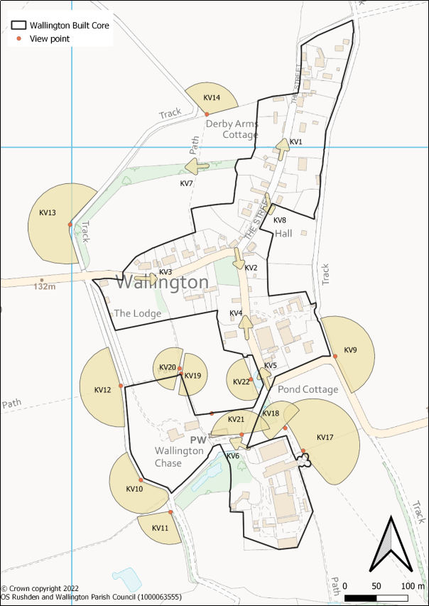
Figure 6.2 Locally significant views (excluding KV15 and KV16)
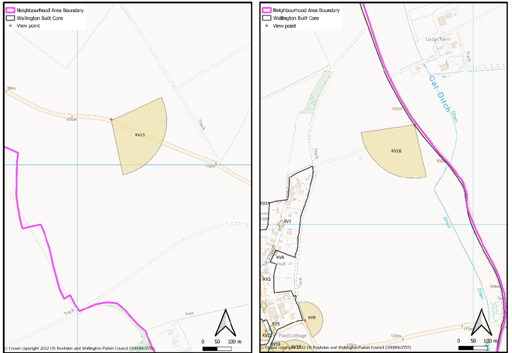
Figure 6.3 Locally significant views (Outer views KV15 and KV16)
(1) POLICY W7: LOCALLY SIGNIFICANT VIEWS
The landscape surrounding the village of Wallington contributes greatly to its character. Development proposals with significant harmful visible impacts on this open landscape and long-distance views will not be supported.
The Plan identifies 22 locally significant views. As appropriate to their scale and nature, development proposals within the shaded arcs of the various views, as shown on Figures 6.2 and 6.3, should be designed in a way that safeguards the locally significant view or views concerned. Applications should be supported by a visual impact assessment.
Conformity reference: NP Objective 1, 2; Local Plan: SP9, SP10; NPPF: 126 to 130