Wallington Neighbourhood Plan 2022 - 2031 Submission Version June 2023
(11) 1 About Wallington
1.1. Wallington is a small Hertfordshire village located approximately three miles to the east of Baldock and roughly equidistant from Stevenage to the south-west and Royston to the north-east. It shares a Parish Council with neighbouring village, Rushden, but remains a separate Parish with a unique character.
1.2. First recorded in the Domesday Book as 'Wallingtone', the village's wooded and sheltered surroundings have made it an ideal location for settlement since records began. The freshwater spring which still flows at the top of The Street, surrounded by a circular wall in Victorian times, has provided water to residents since the Bronze Age and there are several Roman sites nearby. The settlement evolved from a predominantly agricultural base and, at the time of the Domesday Survey, the land was divided into two manors. Evidence of manorial strip farming remains in the surrounding fields which continue to be worked by local farms today.
1.3. The 2011 Census recorded that the parish is home to approximately 150 residents living in 54 dwellings (the 1901 census population was 152 down from 274 in 1841). There is a village hall and playground, a church, and a small triangular village green with a well, and two further pond areas, one adjacent to the Street and the other (Carter or Parson's Pond) to the west of the Church. These shared spaces host a lively community scene, with a variety of activities and events taking place across the calendar. The village is well loved by its residents, most of whom are long-standing and many of whom participate actively in village events. Both homeowners and renters remain in the village longer than national averages.
1.4. It sits within some of the highest quality countryside in north Hertfordshire, comprising two landscape character areas: the Wallington Scarp slopes; and the Weston–Green End Plateau. Much of the parish is characterised by chalky boulder clay woodlands and meadows, which provide an important habitat for a wide range of species including the skylark, linnet and spotted flycatcher. The north-western part of the parish is characterised by shallow lime-rich soils over chalk and limestone. There is a distinct change in the landscape and to a large extent the countryside as a result of the change in soil type from the lime-rich loamy/clayey soils with impeded drainage to the shallow free draining very chalky soil.
1.5. The village is shielded against coalescence with Baldock by the Green Belt to the west and retains an unusually green and open character due to the low density of housing, and the number of green spaces within and around its borders. The Icknield Way Path passes through the village on its 110-mile journey from Ivinghoe Beacon in Buckinghamshire to Knettishall Heath in Suffolk. Local footpaths and bridleways retain an unusually quiet and peaceful nature and are greatly enjoyed by a large number of village residents and local neighbours alike.
1.6. The village retains a rich and varied tapestry of historic buildings and architecture: Historic England records 18 listed buildings in the neighbourhood plan area, plus the phone box. Its church, the Church of St Mary, is a Grade II* listed building lying at the southern end of the village, built of local clunch and limestone. The earliest mention of the church is 1190 but the current building is largely of 14th- and 15th-century origin. Village residents include campanologists for the tower's six bells, five of which date from 1794, and organists. The village hall remains an active and lively focal point for village events throughout the year, with an attractive garden and playground area. The village boasts a wide range of architectural styles reflecting the changing composition of its residents through the ages.
1.7. The village has a place in the history of English literature as the author George Orwell (Eric Blair) lived in a small cottage at No. 2 Kits Lane, then known as The Stores, from 1936 to 1940. Although renting the cottage until 1946, his visits after 1940 were sporadic. Orwell believed that running the village shop allied to the publisher's advance he had received for The Road to Wigan Pier would provide a financial basis to enable him to get married. He duly did so, marrying his first wife, Eileen O'Shaughnessy, at the village church of St Mary in June 1936. A number of his well-known essays and novels were written in the village including The Road to Wigan Pier, Homage to Catalonia, and Coming Up For Air. The village is seen by many as a major influence on the setting for Animal Farm given that it possesses a Great Barn, and a Manor Farm, and the book having a named setting of 'Willingdon': similarly the rural section in his novel 1984 is very similar in depiction to Wallington and its surrounds.
1.8. Further information about the village can be found on the Parish Council website: https://rushdenandwallingtonpc.co.uk.
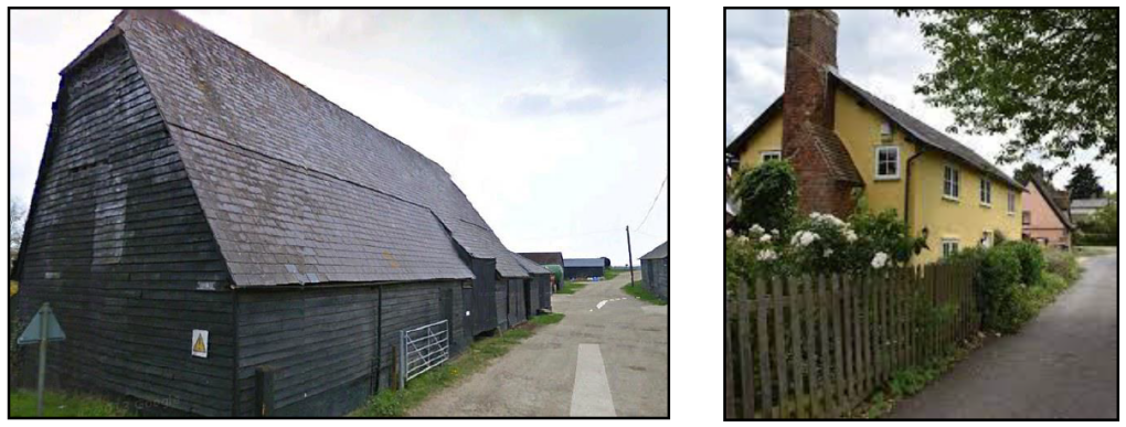
Images show The Great Barn and the village centre