Wallington Neighbourhood Plan 2022 - 2031 Submission Version June 2023
4 Spatial strategy
Policy W1: Location of development
Purpose
4.1. Wallington is classified by NHDC as a category B village, which means that limited infilling development, which does not extend the built core of the village, will be allowed. The Local Plan does not define the extent of the built core for Wallington, therefore Policy W1 provides a definition and boundary for this. It should be noted that development can occur beyond the built core area, where it is an appropriate use within the countryside, as supported either by national or local policies. Policy W1 also seeks to ensure that proposals make the best use of suitable brownfield land, where available, before greenfield land is released for development.
Justification
4.2. Most of the neighbourhood area is classed, within strategic policy, as "Rural Area beyond the Green Belt", except for a small area on the western edge, which is within the Green Belt. The area falls within two landscape character areas, identified in the North Herts and Stevenage Landscape Character Assessment and shown on Figure 4.1. These provide guidance on capacity for development in the area:
- The Wallington Scarp Slopes (Area 223), covering the north of the area and to the east of the village: Large-scale development (>5ha) is considered inappropriate given the isolated landscape. Smaller development (<5ha) would also be difficult to accommodate on the steeply sloping, undulating landscape. Landscape capacity for even small urban extensions is therefore considered to be low.
- Weston-Green End Plateau (Area 222), covering most of the village and land to the west and south: Large-scale development (>5ha) is considered inappropriate given the rural and small-scale nature of the existing settlement. Smaller development – infill could be considered appropriate but must be carefully designed in order to complement the existing character and to avoid erosion of the important green and open spaces that contribute to landscape character.
4.3. NHDC's Local Plan uplifts Wallington village's classification in the settlement hierarchy to a Category B village. This means that limited infill development, that does not extend the built core of the village, would be permitted. The Local Plan does not, however, define the extent of what is meant by the built core. It suggests that whilst it should be possible to assess on a case-by-case basis whether a site is within the built core, this is something that communities may wish to explore and define through their neighbourhood plan.
4.4. The built core, or village envelope as it is sometimes referred to, is essentially a line that is drawn on a plan around a village, which reflects its built form. It is used as a policy tool to define the area where a set of plan policies are to be applied. There are many advantages to defining the built core including to:
- clearly demark the settlement from open countryside;
- ensure a more plan-led and controlled approach to future housing growth;
- protect the countryside from unnecessary development and prevent ribbon development;
- enable a co-ordinated and consistent approach for refusing planning applications, which are unacceptable in planning terms;
- allow for more certainty to developers/land owners with sites/land within the boundary, as long as they adhere to all other plan policies; and
- allow the development of small sites which cannot be identified as allocations.
4.5. Policy W1 defines the built core of Wallington. The criteria used to define the boundary is included in Appendix B, along with a commentary. The boundary itself is shown on Figures 4.1 and 4.2 (inset).
Infilling within the built core boundary is considered acceptable where it is in conformity with the policies of the Local Plan and this Neighbourhood Plan. Existing brownfield and farmyard sites present a preferred source of development land. It should be noted that land at Bygrave Lodge Farm, Baldock, is a waste management facility (anaerobic digestion) that falls within the neighbourhood area and which is safeguarded by Policy 5 (Safeguarding of Sites) of the adopted Waste Local Plan. Any proposals which come forward within the vicinity of this facility must accommodate the existing facility and ensure that development does not prevent or prejudice the operation of the facility.
(2) POLICY W1: LOCATION OF DEVELOPMENT
- Development proposals in the Wallington Neighbourhood Area shall be focused within the built core of the village, as defined in Figures 4.1 and 4.2, and in accordance with Policy W3 (Residential development within the built core).
- Development proposals outside the built core of the village will only be supported where:
- it is in accordance with the development plan policies on appropriate uses in the countryside;
- it does not negatively impact the important green spaces that contribute to landscape character, as set out in Policy W4, or the Local Green Spaces identified in Policy W8, or the locally significant views, as set out in Policy W7;
- it brings redundant or vacant agricultural/farm buildings or historic buildings of heritage value back into optimal beneficial use in a manner that does not cause harm in terms of additional traffic;
- it relates to necessary utility infrastructure;
- Proposals should make the best use of suitable brownfield and farmyard land, where available, before greenfield land adjacent to or beyond the built core is released.
Conformity reference: NP Objective: 1, 2; NHDC Local Plan (2022): SP1, SP2, SP5, SP8; NPPF: 11, 13, 29, 60, 69, 70, 78, 79, 80, 84, 85, 93, 119-121, 147-151
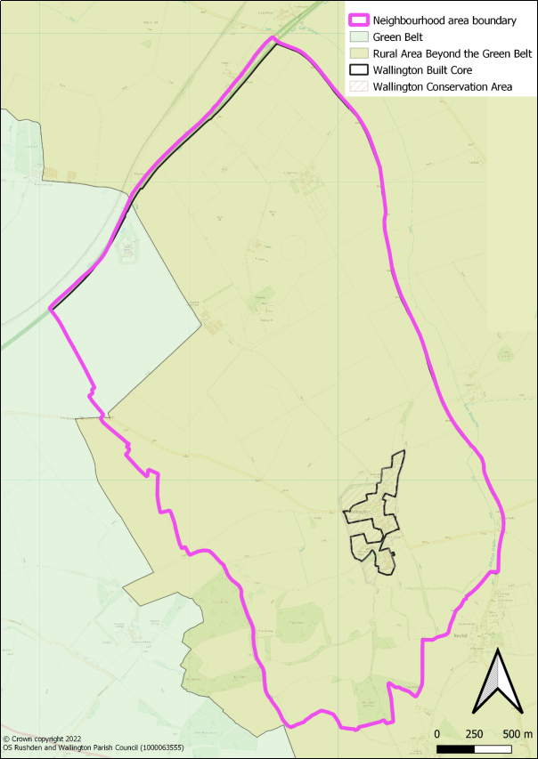
Figure 4.1: Built core of Wallington
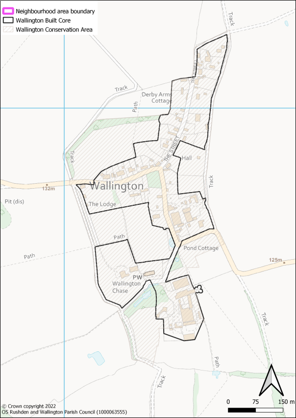
Figure 4.2: Built core of Wallington (inset)