Further Proposed Modifications to the North Hertfordshire Local Plan 2011- 2031
(111) FM 010
Page 6, Paragraph 1.5 and Footnote 1
Modification
The National Planning Policy Framework (NPPF)1 was first published in 2012 and was revised in 2018. The NPPF sets out the Government's planning policies for England and must be taken into account along with other national planning policy in the preparation of local and neighbourhood plans and in determining planning applications. The NPPF is supplemented by detailed Planning Practice Guidance (PPG), first released in 2014, which provides additional detail on certain topics. Local plans must be consistent with national planning policy to pass examination. This Local Plan has been prepared in accordance with the 2012 version of the NPPF.
1 National Planning Policy Framework (DCLG) March 2012 – http://www.communities.gov.uk https://www.gov.uk/government/publications/national-planning-policy-framework--2
Reason/Source for Further Modification
To ensure the plan is positively prepared, and consistent with national policy; factual update
(3) MM 004 / FM 011
Page 7, Paragraph 1.12
Modification
The first step in preparing a neighbourhood plan is to define a neighbourhood area. There are currently eleven thirteen neighbourhood planning areas designated within the District with one further community another two communities considering preparing a neighbourhood plan. Three neighbourhood plans have been "made" and form part of the Development Plan, Pirton, Wymondley and Preston. Those plans under preparation include the parishes of Kimpton, Ashwell, Codicote, Barkway and Nuthampstead, Ickleford, St Ippolyts, St. Pauls Walden, Wymondley, Preston and Knebworth, Wallington and the joint neighbourhood planning area of Bygrave, Baldock & Clothall.
Reason/Source for Further Modification
To ensure the plan is positively prepared; factual update
(2) FM 012
Page 8, Paragraph 1.19 (Footnote 3)
Modification
North Hertfordshire Statement of Community Involvement updated xxx 2015 July 2020.
Reason/Source for Further Modification
To ensure the plan is positively prepared; factual update
(1) FM 013
Page 9, Paragraph 1.20 (Footnote 4)
Modification
North Hertfordshire Local Development Scheme January 2016 April 2017
Reason/Source for Further Modification
To ensure the plan is positively prepared; factual update
FM 014
Page 9, After 1.27 (New paragraph)
Modification
Further consultation was undertaken on the Inspector's Proposed Main Modifications in 2019 and 2021.
Reason/Source for Further Modification
To ensure the plan is positively prepared; factual update
FM 015
Page 11, Paragraph 2.6 and Footnote 8
Modification
North Hertfordshire is a diverse area. The total population figure for North Hertfordshire, from the 2015 Mid-Year Estimates, was 131,696 (males = 64,621 and females = 67,075) 2019 Mid-Year Estimates, was 133,570 (males = 65,382 and females = 68,188)8. Over 70% of the population live in the four main settlements of Hitchin, Letchworth Garden City, Royston and Baldock.
8 ONS (201 6 9) Mid 2015 2019 Population Estimates for UK, England and Wales, Scotland and Northern Ireland
Reason/Source for Further Modification
To ensure the plan is positively prepared; factual update
(1) FM 016
Page 12, Paragraph 2.7 / Footnote 9
Modification
The District age profile differs from the East of England profile as shows that there is a lower proportion of 15-29 year olds than in Hertfordshire (North Hertfordshire 15.7% 14.9% compared to East of England 17.8% 16.6% in the county). There are, however, more in the age groups from 30-54 (North Hertfordshire 36 % compared to East of England 33.6%) However, the proportion of people in the District in the 30 – 54 age group mirrors the proportion in the county as a whole (North Hertfordshire 35.1% compared to 34.9% for Hertfordshire)9.
9 ONS ( 2016 2019) Population Estimates by single year of age
Reason/Source for Further Modification
To ensure the plan is positively prepared; factual update
(11) FM 017
Page 12, Paragraph 2.8 / Footnote 10
Modification
Official statistics indicate that the population is likely to increase over the next 15 10 years by just over 24,000 nearly 9,000 residents (population estimate at 2031 – 153,400 146,500)10. This is due to a combination of factors, including people living longer, changes in social patterns, and the attractiveness of the District as a place to live. This will put considerable pressure not just on our housing numbers but on vital social support mechanisms such as schools and GP surgeries as well as our transport infrastructure.
10 Stevenage and North Hertfordshire SHMA Update 2015 ONS 2016
Reason/Source for Further Modification
To ensure the plan is positively prepared; factual update
(1) FM 018
Page 12, Paragraph 2.10 and Footnotes 11-13
Modification
More than 8 in 10 (86.9%) (87.6%) of North Hertfordshire's 16-64 year olds are economically active (in or seeking employment) compared to a national figure of 79% 77.8%11. The unemployment rate in North Hertfordshire is 3.4% 2.8%; this is below the East of England figure (3.8%) (3.6%) and below the national rate (4.2%) (5.1%)12. Approximately 1 in 5 (13.1%) (12.4%) of North Hertfordshire's 16-64 year olds are economically inactive13.
11 Nomis ( 2016 2020) – Official Labour Market Statistics; Employment and unemployment (Apr 2015 – Mar 2016) (Oct 2019 – Sept 2020)
12 Nomis (2016) (2020) – Model based estimates of unemployment (July 2016) (Sept 2020)
13 Nomis (2016) (2020) – Official Labour Market Statistics; Employment and unemployment (Apr 2015 – Mar 2016) (Oct 2019 – Sept 2020)
Reason/Source for Further Modification
To ensure the plan is positively prepared; factual update
FM 019
Page 12, Paragraph 2.11 and footnote 14
Modification
According to the 2015 2019 Index of Multiple Deprivation, North Hertfordshire is relatively affluent compared to other local authority areas. The District ranks 271st 269th out of 326 317 local authority areas in England (1 being the most deprived)14. None of the District's population lives in areas within the bottom 10% of Super Output Areas (SOA) nationally, i.e. in the most deprived parts of the country. North Hertfordshire does however have four five areas in the next two cohorts, i.e. those which are in the top 30% are seen as being most deprived, this includes one area in Hitchin and three four in Letchworth Garden City.
14 Department for Communities and Local Government (2015) – English indices of deprivation 2015 Ministry of Housing, Communities and Local Government English indices of deprivation 2019
Reason/Source for Further Modification
To ensure the plan is positively prepared; factual update
(2) FM 020
Page 12-13, Paragraph 2.12 and footnote 15
Modification
On the whole the quality of life in North Hertfordshire is good. Life expectancy in North Hertfordshire is similar to the national figure; the male rate is currently 80.4 81 years compared to 79.4 79.8 years for England, and the female equivalent is 83.2 84.3 years compared to 83.1 83.7 years nationally. Life expectancy is 3.7 4.7 years lower for men in the most deprived areas of North Hertfordshire than in the least deprived areas15.
15 Public Health England (2015) (2019 - 2020) – North Hertfordshire Health Profile 2015
Reason/Source for Further Modification
To ensure the plan is positively prepared; factual update
(1) FM 021
Page 13, Paragraph 2.14 and footnote 16
Modification
Adult and child obesity rates in North Hertfordshire are below the national and regional averages. Adult obesity rates in the District at 2020 were 58.2% of all adults compared with a national rate of 62.3% which still presents a key challenge for the District 19.1% v 23.0% for adults and 12.6% v 19.1% for children; however, these figures still present a key challenge for the District16.
16 Public Health England (2015) (2019 - 2020) – Obesity Profile North Hertfordshire Health Profile 2015
Reason/Source for Further Modification
To ensure the plan is positively prepared; factual update
(1) FM 022
Page 13, Paragraph 2.15 and footnote 17
Modification
Like most areas North Hertfordshire did not escape the detrimental affects of the economic downturn in 2009 and many variables including unemployment and job growth figures suffered as result. Figures have only recently returned to pre-2008 levels and the local employment environment is improving and the figures are moving in the right direction. It is estimated that there are around 48,800 54,000 jobs17 in North Hertfordshire.
17 Nomis (2014) Nomis Local Authority Profile 2019
Reason/Source for Further Modification
To ensure the plan is positively prepared; factual update
(1) FM 023
Page 13, Paragraph 2.18
Modification
The District has a working age population of 81,700 81,600 of which 71,800 76,700 are economically active. The majority of these are employees and work full-time but a small proportion of the population are self employed (10.4%) (10.5%).
Reason/Source for Further Modification
To ensure the plan is positively prepared; factual update
(1) FM 024
Page 13, Paragraph 2.19
Modification
In 2015 the median gross pay for full-time workers in the area (residence based) was £637.3 per week. This was considerably higher than the median earnings of those living in the East of England region (£551.0 per week) and the National Average (£529.6 per week), reflecting the high earnings associated with the proportion of the public that commute out of the District.
In 2020, the median gross pay for full time employees was £644.10 per week which compares favourably with the national average of £586.70.
Reason/Source for Further Modification
To ensure the plan is positively prepared; factual update
(2) FM 025
Page 13, Paragraph 2.20
Modification
15.7% 16.65% of the population do not have access to a car. This is much lower than the national figure (24.9%) (25.8%) and slightly lower than regionally (17.7%) (16.93%).
Reason/Source for Further Modification
To ensure the plan is positively prepared; factual update
(2) FM 026
Page 14, Paragraph 2.22 and footnote 20
Modification
House prices in the District are well above the regional and national averages, although slightly below the average for Hertfordshire which is skewed significantly upwards by prices in areas such as St Albans. The average cost of a home in the District is around £350,000 £355,000, meaning prices are around one-quarter 44%higher than the national average20.
20 Quarterly House Price Data for Hertfordshire (HertsLIS, 2016 ) ONS House Price Statistics for Small Areas 2019-2020
Reason/Source for Further Modification
To ensure the plan is positively prepared; factual update
(1) FM 027
Page 14, Paragraph 2.25 and footnote 22
Modification
There are currently more than 1,600 2,100 households on the local authority housing register awaiting assistance with their housing needs22
22 Stevenage and North Hertfordshire Strategic Housing Market Assessment Update: Volume Two (ORS, 2016) NHDC Summary Statistics 2020
Reason/Source for Further Modification
To ensure the plan is positively prepared; factual update
(7) FM 028
Page 16, Paragraph 2.39
Modification
The HMA geography has informed the preparation of Strategic Housing Market Assessments (SHMA) which have been were completed on a 'best fit' basis by groups of local authorities. The Council has prepared a joint SHMA26 with Stevenage which identifies , at the time of the plan's submission, identified an objectively assessed need (OAN) for 13,800 homes in North Hertfordshire and 7,600 homes within Stevenage over the period 2011-2031. Further Government household projections were released during the examination and a revised assessment for North Hertfordshire identified an OAN of 11,500 homesx. The plans of both authorities show that their individual housing needs can be accommodated in full within their administrative areas.
X Review of the Official Projections for North Hertfordshire (ORS, 2020)
Reason/Source for Further Modification
To ensure the plan is positively prepared, justified and consistent with national policy following the Matter 21 hearing as supported by document ED191A
(5) FM 029
Page 17, Paragraph 2.41
Modification
Luton's plan and associated evidence base identifies a requirement for approximately 18,000 homes in the Borough but has capacity for just 7,000 8,500. The most recent projections for Luton did not lead to a meaningful change in the housing situation presented in Luton's adopted Plan. The issue of unmet needs from Luton is therefore a significant matter to be considered under the Duty to Co-operate.
Reason/Source for Further Modification
As above
(2) FM 030
Page 19, Paragraph 2.45
Modification
A number of key plans and strategies are produced at a county level to which the Council should have regard to in preparing the Local Plan. Key amongst these is are the:
- Strategic Economic Plan , 2017 - 2030
and Growth Dealofboththe Hertfordshire Local Enterprise Partnership (LEP)and the Greater Cambridge, Greater Peterborough LEP. - Hertfordshire Local Nature Partnership
- Hertfordshire Waste and Minerals Local Plans
- Hertfordshire Local Transport Plan
Reason/Source for Further Modification
To ensure the plan is positively prepared; factual update
(5) FM 031
Page 19, Paragraph 2.46
Modification
In October 2013 the Hertfordshire LEP published their Strategic Economic Plan for the county which was refreshed in July 2017. This strategy sets out the LEPs vision, that by 2030, Hertfordshire will be the leading economy at the heart of the UKs Golden Triangle, which encompasses Cambridge, Oxford and London. To deliver the vision, the LEP has identified a number of priority areas, which represent major opportunities for Hertfordshire. These include:
- Maintaining Hertfordshire's global excellence in science and technology;
- Harnessing Hertfordshire's relationship with London (and elsewhere);
andRe-invigorating Hertfordshire's places for the 21st Century ; and- Building the wider foundations for growth across both businesses and people.
Reason/Source for Further Modification
To ensure the plan is positively prepared; factual update
(3) FM 032
Page 19, Paragraph 2.48 (delete)
Modification
Given that the northern part of the District is heavily influenced by the Cambridgeshire economy, the District is also part of Greater Cambridge, Greater Peterborough LEP. The goal of the Greater Cambridge, Greater Peterborough LEP is to create an economy with 100,000 major businesses and create 160,000 new jobs by 2025, in an internationally significant low carbon, knowledge-based economy, balanced wherever possible with advanced manufacturing and services.
Reason/Source for Further Modification
To ensure the plan is positively prepared; factual update
FM 033
Page 19, Paragraph 2.49
Modification
The Hertfordshire LEP s are is responsible for bidding and prioritising infrastructure investment within their areas the county.
Reason/Source for Further Modification
To ensure the plan is positively prepared; factual update
FM 034
Page 20, Paragraph 2.56
Modification
The County Council is also the Highway Authority with responsibility for transport matters. This Plan supports key priorities and proposals from the Hertfordshire Local Transport Plan (LTP3) (LTP4) adopted in 2011 2018. LTP3 LTP4 sets out the transport strategy for Hertfordshire (over the period from 2011 2018 to 2031), the goals and challenges to be met, and outlines a programme of transport schemes and initiatives to be delivered subject to available funding. The LTP covers all modes of transport - including walking, cycling, public transport, car based travel and freight - and takes account of the effect of transport on wider aspects including the economy, environment, climate change and social inclusion.
Reason/Source for Further Modification
To ensure the plan is positively prepared; factual update
(2) FM 035
Page 20, Paragraph 2.57
Modification
It will therefore be necessary to both have regard to this strategy and work with the Highway Authority when taking forward the development sites set out in the Local Plan. Work on the next iteration of the LTP – the 2050 Transport Vision – is well under way and is expected to be finalized by the end of 2016. This vision will set out proposals for accommodating growth in this Local Plan and other local plans in Hertfordshire.
Reason/Source for Further Modification
To ensure the plan is positively prepared; factual update
(3) FM 036
Page 21, Paragraph 2.59
Modification
North Hertfordshire Corporate Council Plan
The North Hertfordshire Corporate Plan 2017-2021recently reviewed in 2016 Council Plan 2021 – 2026 sets out the Council's vision and corporate objectives for the District. The council's vision set out in the Corporate Council Plan is:
'making North Hertfordshire a vibrant place to live, work and prosper'
"To make North Hertfordshire a district in which everyone who lives, works or visits is able to flourish."
Reason/Source for Further Modification
To ensure the plan is positively prepared; factual update
(1) FM 037
Page 21, Paragraph 2.60
Modification
The Corporate Plan draws together the key elements of the Council's proposals for how it will serve the District over the next few years. As well as looking at the current status of the authority, it considers the opportunities and risks facing the District, and also identifies the high level projects which will ensure the Corporate Plan is being delivered. The Council plan sets out the priorities that the Council will address over the next five years. The plan also lays out how North Hertfordshire District Council will achieve its aims for the district.
Reason/Source for Further Modification
To ensure the plan is positively prepared; factual update
(4) FM 038
Page 21, Paragraph 2.61
Modification
The Corporate Plan sets the following three objectives:
To work with our partners to provide an attractive and safe environment for our residents, where diversity is welcomed and the disadvantaged are supportedTo promote sustainable growth within our District to ensure economic and social opportunities exist for our communities, whilst remaining mindful of our cultural and physical heritageTo ensure that the Council delivers cost effective and necessary services to our residents that are responsive to developing need and financial constraints
The Council Plan sets out the following objectives:
- Be a welcoming, inclusive, and efficient council;
- Build thriving and resilient communities;
- Respond to challenges to the environment;
- Enable an enterprising and co-operative economy;
- Support the delivery of good quality and affordable homes.
Reason/Source for Further Modification
To ensure the plan is positively prepared; factual update
(98) MM 010 / FM 039
Page 32, Policy SP2
Modification
|
Policy SP2: Settlement Hierarchy and Spatial Distributionx |
|
|
Between 2011 and 2031, the plan make s provision for at least 13,000 new homes.
Approximately 80% |
|
|
|
|
Approximately 13% of housing, along with supporting infrastructure and facilities will be delivered within the adjusted settlement boundaries of the following five villages for the levels of development indicated :
|
|
|
|
|
The remaining development will be dispersed across the District as set out below…
|
|
[Remainder of proposed Policy SP2 incorporating MM010 unchanged]
Reason/Source for Further Modification
To ensure the plan is positively prepared, justified, effective and consistent with national policy following the Matter 21 to 26 hearings as supported by the statements to those sessions and documents including ED161, ED172, ED191A and ED191B
Note: Indicated figures for the five villages are for development within the adjusted settlement boundary and will not be the same as the figures presented in Chapter 13 which are for the whole parish
MM 011 / FM 040
Page 33, After paragraph 4.11 (new paragraphs)
Modification
Based on the policies and allocations of this plan, it is anticipated that approximately four in every five new homes delivered over the plan period will be built within the adjusted settlement boundaries of the towns…
[remainder of proposed MM011 unchanged]
Reason/Source for Further Modification
For effectiveness consequent to FM039 [Policy SP2] and FM057 [Policy SP8]
(11) MM 012 / FM 041
Page 33, After paragraph 4.12 (new paragraph)
Modification
Five villages have been identified that will support higher levels of new housing allocations than the Category A villages :
- Knebworth and Codicote are the two largest villages within North Hertfordshire and support a range of services, including a station at Knebworth;
- Ickleford and Little Wymondley provide opportunities to accommodate further residential development in close proximity to neighbouring towns along with sustainable transport connections; and
- Barkway as a focus for development in the rural east of the District
Reason/Source for Further Modification
For effectiveness following the Matter 26 hearing sessions and consequential to changes to Policy SP2
(1) MM 014 / FM 042
Page 35, Policy SP3
Modification
|
Policy SP3: Employment |
|
The Council will proactively encourage sustainable economic growth, support new and existing businesses and seek to build on the District's strengths, location and offer. We will
|
Reason/Source for Further Modification
For legal compliance (criteria b; e; g and h) in response to the Use Class Order amendments and effectiveness (criterion d) following the Matter 29 hearing as supported by the statement to that session and documents including ED176, ED203 and ED214
(1) FM 043
Page 35, Paragraph 4.19 (delete paragraph)
Modification
In planning, employment land usually refers to 'B-class' uses and includes:
B1(a) – officesB1(b) – research and developmentB1(c) – light industryB2 – general industry; andB8 – storage and distribution
Reason/Source for Further Modification
For legal compliance in response to the Use Class Order amendments following the Matter 29 hearing as supported by the statement to that session and documents including ED203 and ED214.
(1) FM 044
Page 36, Paragraph 4.26
Modification
Trend-based forecasts reflect these patterns and anticipate continued increases in out-commuting from North Hertfordshire over the plan period1. Unchecked, this would lead to increased pressure on transport infrastructure that is already under strain at peak periods. This Plan therefore makes employment provision for offices, research and development, light industrial, general industry and storage and distribution at above modelled levels.
Reason/Source for Further Modification
As above
(1) MM 015 / FM 045
Page 37, Paragraph 4.28
Modification
A significant new employment allocation for certain E class uses (office, research and development, industrial processes), B2 (industrial) and B8 (storage and distribution) class uses site will be developed out at the east of Baldock, supporting the proposed increase in residential development in the town (see Policy SP8). The allocation benefits from proximity to existing employment uses as well as existing and planned residential development. It has access to the strategic road network via the A505 Baldock Bypass.
Reason/Source for Further Modification
As above
(2) FM 046
Page 37, Paragraph 4.33
Modification
Within these designated areas, an appropriate range of offices, research and development, light industrial, general industry and storage and distribution B-class uses will be permitted in line with the detailed policies of this Plan.
Reason/Source for Further Modification
As above
(1) FM 047
Page 3, Paragraph 4.34
Modification
B-class uses will not be solely confined to designated employment areas. A number of employment premises are located outside of defined areas and these will continue to be supported where they are compatible with other surrounding uses. In particular, office uses will continue to be supported in the main town centres (see Policy SP4), in line with national planning policy.
Reason/Source for Further Modification
As above
(1) FM 048
Page 3, Paragraph 4.35
Modification
Beyond our main towns, there is a steady demand for rural employment land and premises. Owing to the size and extensive spread of rural settlements these types of development are best dealt with on a case-by-case basis rather than through allocations, although our general approach will be to direct concentrations of rural business to the Category A larger villages. There are quite sizeable employment sites in villages such as Ashwell, Codicote, Kimpton, Little Wymondley and Weston which provide rural jobs and should be retained.
Reason/Source for Further Modification
For effectiveness consequential to modifications to Policy SP2
(1) FM 049
Page 38, Paragraph 4.36
Modification
Approximately 45% of all jobs fall within the office, research and development, light industrial sectors or into the B uses classes. The rest of the jobs in the local economy consist of services such as retail, health, education and leisure, or 'footloose' careers in sectors such as construction and the trades. The role of these non-B-class sectors in the overall employment balance of the District is recognised and will continue to be supported where appropriate.
Reason/Source for Further Modification
For legal compliance in response to the Use Class Order amendments following the Matter 29 hearing as supported by the statement to that session and documents including ED203 and ED214.
(8) MM 017 / FM 050
Page 3, Policy SP4
Modification
|
Policy SP4: Town Centres, |
||||||||||||||||||||||||||||||||||||||||||||||||||||||||||||||||||||||||||||||||
|
The Council will make provision for an appropriate range of retail and service facilities across the District and are committed to protecting the vitality and viability of all centres. We will:
38,100 gross sq.m is a district wide retail capacity but it is principally derived from the retail capacity projections for the four town centres, as indicated below:
The three town centres of Baldock, Hitchin and Letchworth Garden City have significant overlapping markets, with spend leakage from Letchworth Garden City to Hitchin and a lack of physical space at Baldock to accommodate its projected retail capacity. To address the leakage and physical capacity across these three centres the indicative distribution and phasing of provision is as follows:
*2016 to 2021 projections includes take-up of vacant units and the implementation of commitments.
|
x Please refer to the Glossary for a definition of comparison and convenience goods [new footnote]
Reason/Source for Further Modification
For legal compliance and effectiveness in response to the Use Class Order amendments following the Matter 29 hearing as supported by the statement to that session and documents including ED203 and ED214 and in response to the Inspector's August letter (Paragraphs 10 and 11)
(1) FM 051
Page 38, After SP4 (new paragraph)
Modification
In relation to policy SP4, retail and service facilities refers to shops, cafés and restaurants (E-class use) along with pubs and drinking establishments and takeaways (sui generis). These were previously Class A uses.
Reason/Source for Further Modification
For effectiveness in response to the Use Class Order amendments following the Matter 29 hearing as supported by the statement to that session and documents including ED203 and ED214
(2) MM 019 / FM 052
Page 39, Paragraph 4.40
Modification
We are committed to promoting the well-being of the town centres in the District. Town centre strategies have been produced for the main centres of Hitchin, Baldock, Letchworth Garden City, and Royston. These promote the vitality and viability of the centres and cover all those aspects of policy guidance with a spatial dimension relevant to town centres, including economic, environmental and social well-being and matters such as community safety, community facilities, traffic management, marketing and delivery. The strategies provide a method of keeping town centre development up-to-date and flexible to take account of ongoing changes in the retail environment, and will inform whether it is necessary to review the retail strategy set out in this Plan. Work on these town centre strategies will commence within 12 months of the adoption of this Plan. They will be monitored and reviewed during the life of this Plan.
Reason/Source for Further Modification
For effectiveness in response to the Inspector's August 2019 letter (Paragraph 10)
(3) FM 053
Page 39, Paragraph 4.41
Modification
Our detailed policies set out our approach to development applications, including for changes of use. In general terms, A1 retail shops will be expected to concentrate within the defined primary frontages with a wider variety of A-classrelated retail and service uses, that are pubs or drinking establishments permissible in secondary frontage areas.
Reason/Source for Further Modification
For legal compliance and effectiveness in response to the Use Class Order amendments following the Matter 29 hearing as supported by the statement to that session and documents including ED203 and ED214
(5) MM 020 / FM 054
Page 39, Paragraph 4.44
Modification
The growth of the District will require additional centres to be provided to serve the largest new developments strategic housing sites. The centres for the two largest sites at Baldock and on the edge of Luton are expected to contain a wider range of retail facilities. Once built, these will become local centres in our retail hierarchy and future proposals within them will be assessed appropriately.
Reason/Source for Further Modification
The Council considers this further change to be non-material but is included here as it amends a previous MM in response to Inspector's August 2019 letter (Paragraph 11)
(4) MM 021 / FM 055
Page 39-40, Paragraph 4.46
Modification
Our evidence shows there will be a steady growth in retail demand over the plan period, although projected growth post-2026 carries a degree of uncertainty due to changing shopping and retail patterns and the effects of Covid- 19 . Projected growth is driven in part by planned population growth but also by underlying changes in the way people shop and how much money they have available to spend. It is anticipated that on-line shopping will continue to grow whilst a certain amount of future demand can be accommodated through the re-occupation of existing, vacant shop units. However, it is also necessary to identify new sites for retail2. Projected retail needs, and particularly those in the post-2026 period, will be kept under review via the monitoring framework and updated retail studies.
Reason/Source for Further Modification
For effectiveness following the Matter 29 hearing
FM 056
Page 43, Paragraph 4.66
Modification
The overarching transport policy document for the area is the Hertfordshire Local Transport Plan (LTP3) (LTP4) which provides the framework for achieving better transport systems in Hertfordshire for the plan period 2011 2018-2031. The LTP4 is in progress which will cover the Hertfordshire 2020 Transport vision and will be consulted on in late 2016. LTP4 was adopted in 2018. The Local Transport Plan covers all modes of transport including walking, cycling, public transport, car based travel, reducing road freight movements and making provision for those with mobility impairments.
Reason/Source for Further Modification
To ensure the plan is positively prepared; factual update
(31) MM 035 / FM 057
Page 47-48, Policy SP8
Modification
|
Policy SP8: Housing |
|
Over the period 2011-2031, housing growth will be supported across the District. We will:
|
Reason/Source for Further Modification
To ensure the plan is positively prepared, justified, effective and consistent with national policy following the Matter 21 to 26 hearings as supported by the statements to those sessions and documents including ED161, ED172, ED191A ED191B, ED215 and ED228 [G&T note]
(7) FM 058
Page 48, Paragraph 4.86
Modification
Our evidence identifies a requirement for 13,800 11,500 homes to be built between 2011 and 2031 to meet the needs of North Hertfordshire49. A modest uplift has been added. This predominantly reflects the fact that, as people live for longer and live in their own homes for longer, it may be more appropriate to assume that more of their needs will be me in the normal housing stock50.
49 Updating the Overall Housing Need (ORS, 2016) Review of the Official Projections for North Hertfordshire (ORS, 2020)
50 Housing requirements are normally calculated on the basis that the proportion of older persons needing specialised accommodation will not change over time.
Reason/Source for Further Modification
To ensure the plan is positively prepared, justified and consistent with national policy following the Matter 21 hearing as supported by document ED191A
(1) MM 037 /FM 059
Page 48, Paragraph 4.89
Modification
More than 4,300 Approximately 5,100 of the required homes are accounted for by completions since 2011, sites which have already obtained planning permission and commenced development and other allowances. This includes two large developments on the edge of Royston with permission for almost 600 homes. These allowances The majority of these homes will be on previously developed land and also include :
- windfalls (those sites which will continue to come forward for development outside of the local plan process)
as well as; and - Letchworth Town Centre as a broad location.
locations. These are areasThis is an area where it is reasonable to assume development might occur in the latter years of the plan, but where we cannot currently identify the exact location. The boundary of the broad location is the same as the Town Centre boundary for Letchworth shown on the policies map.The majority of these 4,300 homes will be on previously developed land.
Reason/Source for Further Modification
To ensure the effectiveness of the plan
MM 038 / FM 060
Page 49, Paragraph 4.95
Modification
The remainder of new homes will be delivered through a range of local housing allocations set out in the detailed policies of this Plan:
More than 850 further homes are identified within pre-existing settlement boundaries and have influenced our target to build 20% of new homes on previously developed land;As part of our comprehensive review of the Green Belt, a number of additional villages have been 'inset' with boundaries drawn to release additional land for development. These locations will contribute around 2,600 homes to our target whilst also ensuring the long-term sustainability of these settlements.A series of developments around the edge of Royston will contribute almost 1,000 further homes; while- Sites for over 2,200 homes, in addition to the strategic sites, are identified within the adjusted settlement boundaries of the towns;
- Sites for nearly 1,600 homes are identified at five village locations identified by Policy SP2; while
- A review of the settlement boundaries in the
Rural Areas Beyond the Green Beltof Category A villages allows for approximately400180 homes.
Reason/Source for Further Modification
To ensure the plan is positively prepared, justified, effective and consistent with national policy following the Matter 22 to 26 hearings as supported by the statements to those sessions and documents including ED161, ED172, ED191A and ED191B
(1) MM 039 / FM 061
Page 49, Paragraph 4.96
Modification
This Plan also makes provision to meet the future needs of the Gypsy and Traveller community. Existing arrangements at the Pulmer Water site near Codicote will be formalised . A new site is allocated at Woodside Place, Danesbury Park Road at the southern edge of the District allowing requirements over the period to 2031 to be met.
Reason/Source for Further Modification
To ensure Plan is positively prepared and justified consequential to FM057
(4) FM 062
Page 49, Paragraph 4.98
Modification
This needs to be balanced against realistic expectations about when we can expect to see new homes being built. This is especially the case on the largest new sites which require the certainty provided by this Plan in order to proceed and can require significant up-front investment in infrastructure such as new roads. As a result, most of the planned new homes are likely to will be delivered after 2021.
Reason/Source for Further Modification
For effectiveness in line with the approach suggested by ED178 (as subsequently superceded by Matter 22 / ED191B)
(4) FM 063
Page 49, After Paragraph 4.98 (new paragraph)
Modification
The spatial strategy proposed by this Plan requires the simultaneous delivery of a number of strategic sites around the main towns. There will be challenges in this approach. These include the capacity of the development industry to deliver and the ability of the market to absorb these new homes. We will support higher delivery rates where possible. This might include using innovative approaches to construction. We will develop a greater understanding of the rates of housing delivery that can be achieved as schemes are progressed and reflect these in the review of the plan as set out in Policy IMR2.
Reason/Source for Further Modification
As above
(5) MM 040 / FM 064
Page 50, Paragraph 4.99
Modification
A stepped approach is considered most appropriate to deal with these issues. An average of 313 homes per year were built over the first nine years of the plan period between 2011 and 2020. Moving forward, housing supply will be measured against targets to deliver an average of 500 homes per year over the first ten years of the plan period (2011 -2021) period to 31 March 2024. For the period beyond 2021, From 1 April 2024 a target of 1,100 1,120 homes per year will apply. Our approach to five-year land supply is set out in Policy IMR1 in Chapter14.
Reason/Source for Further Modification
To ensure the plan is positively prepared, justified, effective and consistent with national policy following the Matter 22 to 26 hearings as supported by the statements to those sessions and documents including ED191B and ED215
(4) MM 043 / FM 065
Page 50, Paragraph 4.105
Modification
In taking this approach, it is recognised that a review of this Local Plan will need to conclude before the end of the plan period in 2031 we are required to undertake a review of the Plan every five years to see if it needs to be updated. This Plan commits to undertaking a full review by the end of 2023, well within the five-year period. It is reasonable to assume that some development will be realised from whichever sites are identified through this process in the period after 2026. An allowance of 500 homes has been included in our housing figures.
Reason/Source for Further Modification
To ensure the Plan is positively prepared and effective in line with the approach suggested by ED178 (as subsequently superceded by Matter 22 / ED191B)
FM 066
Page 50, Paragraph 4.106
Modification
Policy IMR2 in the Monitoring and Delivery Chapter of this Plan sets out in greater detail how we expect the local plan review process to occur.
Reason/Source for Further Modification
For effectiveness consequential to modifications to Policy SP8 and Paragraph 4.105
(22) MM 045 / FM 001
Page 52, Policy SP9
Modification
|
Policy SP9: Design and sustainability |
|
The Council considers good design to be a key aspect of sustainable development. We will x. Require Strategic Masterplans to be produced for Strategic Housing Sites and other significant development by the landowner/applicant in collaboration with the Council and subject to consultation with key stakeholders and the community. Significant development generally comprises residential developments above 100 dwellings. Exceptionally, developments under 100 dwellings will be considered significant if there are site specific complexities and sensitivities that require a masterplan-led approach. In some circumstances a Strategic Masterplan may also be required to consider the cumulative impact of more than one site to support a co-ordinated and integrated approach to place-making and design.
x. Ensure Strategic Masterplans are informed by a technical and design evidence base and include the following for Strategic Housing Sites and where applicable for other significant development:
x. Confirm the scope and contents of individual Strategic Masterplans with applicants in pre-application discussions. To ensure sites are comprehensively planned and delivered planning applications should be preceded by and consistent with a Strategic Masterplan agreed by the Council. Where applications have already been submitted to the Council a Strategic Masterplan should be agreed with the Council prior to or as part of the grant of planning permission. Adherence to the Strategic Masterplan will be secured through planning conditions and/or legal agreement.
|
Reason/Source for Further Modification
For consistency with national policy and for effectiveness following Matter 32 hearing session
(6) FM 002
Page 52, Paragraph 4.116 (and new paragraphs thereafter)
Modification
The largest sites will be masterplanned in accordance with any requirements set out in Policies SP14-SP19 and the Communities section of this Plan to maximise their benefits. Policy SP9 sets out the strategic design and masterplanning expectations of the Council for the Strategic Housing Sites and other significant development. The policy has to apply to a wide range of developments in terms of quantum, scale and complexity. The policy should be applied in its entirety to Strategic Housing Sites but for other significant development a tailored and case-by-case approach will be required to identify a proportionate level of masterplan and design detail to secure design quality dependant on site specific issues and the level of detail submitted with any planning application.
4.xxx Strategic Masterplans are an effective tool in securing comprehensive and timely delivery and securing design quality and positive place outcomes. Masterplans support comprehensive, integrated, well- planned and sustainable places in terms of the natural, built and historic environment. An effective masterplanning process helps to support a multi-disciplinary, integrated, inclusive and collaborative approach to securing quality design and delivery. It also assists with resolving and co-ordinating planning issues at an early stage in the process speeding up decision-making and driving forward delivery through a shared vision. This both de-risks and provides certainty.
4.xxx Strategic Masterplans will be prepared on a staged basis, initially evaluating and agreeing baseline technical, character and design analysis and assessments, then agreeing a shared vision and set of place-making objectives, exploring and testing a series of options with stakeholder input and then the agreement of a preferred option and masterplan.
4.xxx For large sites that are developed over a long time period, strategic masterplans may require review and be flexible to adapt to changing circumstances. A Strategic Masterplan is not a blueprint, it is a framework within which further planning and design instruction can emerge over time.
Reason/Source for Further Modification
As above
(1) FM 067
Page 53, Policy SP10(e)
Modification
- Work with Hertfordshire County Council and education providers to ensure the planning system contributes to the provision of sufficient school places and facilitates the provision of new or expanded schools in appropriate and accessible locations . This will include monitoring of projected future demand to inform the review of this plan in relation to secondary education provision for the Stevenage area;
[remainder of policy unaffected]
Reason/Source for Further Modification
To ensure the plan is positively prepared and consistent with national policy in response to the Inspector's August 2019 letter.
FM 068
Page 54, After Paragraph 4.127 (new paragraph)
Modification
Forecasting education demand that will arise from new developments over the long-term is challenging. It is difficult to predict with certainty how and when school places will be needed until developments are built and new families move in. This is a particularly complex issue in the Stevenage area where housing developments have been proposed by three local authorities (North Hertfordshire, East Hertfordshire and Stevenage) across a wide number and variety of sites contained in separate local plans. These plans set out allocations and requirements for secondary education that could meet demand well into the 2030s. However, this issue needs to be kept under review particularly as alternative sites and opportunities which supplement those identified in current Plans and / or better address the County Council's operational preferences may arise over this period. We will monitor long-term forecasts of demand with the County Council to inform the early review set out in Policy IMR2.
Reason/Source for Further Modification
To ensure the plan is positively prepared and consistent with national policy in response to the Inspector's August 2019 letter.
(5) MM 050 / FM 069
Page 56, Policy SP12
Modification
|
Policy SP12: Green infrastructure, landscape and biodiversity |
|
We will accommodate significant growth during the plan period whilst ensuring the natural environment is protected and enhanced. We will:
x. Consider and respect landscape character , scenic beauty and locally sensitive features, particularly in relation to the Chilterns Area of Outstanding Natural Beauty; x. Protect, enhance and manage sites in accordance with the following hierarchy of designations and features :
|
Reason/Source for Further Modification
For effectiveness & consistency with national policy and in response to the Inspector's August 2019 letter (Paragraph 14) and following the Matter 28 hearing session
(2) MM 056 / FM 070
Page 57, Policy SP13
Modification
|
Policy SP13: Historic environment |
|
The Council will balance the need for growth with the proper protection and enhancement of the historic environment. When considering the impact of a proposed development on the significance of a designated heritage asset, great weight will be given to the asset's conservation and the management of its setting. We will pursue a positive strategy for the conservation and enjoyment of the historic environment through: a. Maintaining a strong presumption in favour of the retention, preservation and enhancement of heritage assets and their setting according to their significance;
|
Reason/Source for Further Modification
For consistency with national policy and in response to the Inspector's August 2019 letter (Paragraph 12)
(6) MM 057 / FM 003
Page 60, After Paragraph 4.174 (new paragraph)
Modification
All strategic sites will be masterplanned pro-actively and collaboratively with the Council and key stakeholders in accordance with Policy SP9 Design and Sustainability and the individual site policy requirements. Planning applications should be preceded by and consistent with an agreed Strategic Masterplan for the site . Adherence to the Strategic Masterplan and any further masterplanning and design requirements will be secured through conditions and/or legal agreements.
Reason/Source for Further Modification
For effectiveness to support effective and comprehensive delivery
(4) MM 058 / FM 004
Page 61, Policy SP14
Modification
|
Policy SP14: Site BA1 – North of Baldock |
|
Land to the north of Baldock, as shown on the
A comprehensive and deliverable Strategic Masterplan for the entire allocation is to be prepared and agreed between the landowner/developer and the Council. Any planning application/s should be preceded by and consistent with an agreed Strategic Masterplan.
Where applications have already been submitted to the Council a Strategic Masterplan should be agreed prior to the or as part of the grant of planning permission.
Any application on part of the site will be assessed against its contribution to the Strategic Masterplan and must not prejudice the implementation of the site as a whole.
Development proposals should provide the following planning and master planning requirements
… [Remaining criteria re-labelled sequentially with no further changes] |
Reason/Source for Further Modification
For consistency with national policy and for effectiveness in supporting sustainable development, design quality and comprehensive delivery
(1) MM 061 / FM 005
Page 63, Policy SP15
Modification
|
Policy SP15: Site LG1 – North of Letchworth Garden City |
|
Land to the north of Letchworth Garden City, as shown on the
A comprehensive and deliverable Strategic Masterplan for the entire allocation is to be prepared and agreed between the landowner/developer and the Council. This should follow and implement Garden City principles. Any planning application/s should be preceded by and consistent with an agreed Strategic Masterplan.
Where applications have already been submitted to the Council a Strategic Masterplan should be agreed prior to the or as part of the grant of planning permission.
Any application on part of the site will be assessed against its contribution to the Strategic Masterplan and must not prejudice the implementation of the site as a whole.
Development proposals should provide the following planning and master planning requirements a. b. How comprehensive integration into the existing pedestrian and cycle public transport and road networks will be secured c. d. e. The approach to trees and hedgerows around and within the site, with the presumption that trees will be retained and any hedgerow losses kept to a minimum f. … [Remaining criteria re-labelled sequentially with no further changes] |
Reason/Source for Further Modification
For legal compliance, consistency with national policy and for effectiveness in supporting sustainable development, design quality and comprehensive delivery
(2) MM 068 / FM 006
Page 65, Policy SP16
Modification
|
Policy SP16: Site NS1 – North of Stevenage |
|
Land to the north of Stevenage within Graveley parish, as shown on the
A comprehensive and deliverable Strategic Masterplan for the entire allocation is to be prepared and agreed between the landowner/developer and the Council. Any planning application/s should be preceded by and consistent with an agreed Strategic Masterplan.
Where applications have already been submitted to the Council a Strategic Masterplan should be agreed prior to the or as part of the grant of planning permission.
Any application on part of the site will be assessed against its contribution to the Strategic Masterplan and must not prejudice the implementation of the site as a whole.
Development proposals should provide the following planning and master planning requirements
… [Remaining criteria re-labelled sequentially with no further changes] |
Reason/Source for Further Modification
For consistency with national policy and for effectiveness in supporting sustainable development, design quality and comprehensive delivery
(3) MM 072 / FM 007
Page 67, Policy SP17
Modification
|
Policy SP17: Site HT1 – Highover Farm, Hitchin |
|
Land to the east of Hitchin, as shown on the
A comprehensive and deliverable Strategic Masterplan for the entire allocation is to be
Where applications have already been submitted to the Council a Strategic Masterplan should be agreed prior to the or as part of the grant of planning permission.
Any application on part of the site will be assessed against its contribution to the Strategic Masterplan and must not prejudice the implementation of the site as a whole.
Development proposals should provide the following planning and master planning requirements
… [Remaining criteria re-labelled sequentially with no further changes] |
Reason/Source for Further Modification
For legal compliance, consistency with national policy and for effectiveness in supporting sustainable development, design quality and comprehensive delivery
(3) MM 075 / FM 008
Page 69, Policy SP18
Modification
|
Policy SP18: Site GA2 – Land off Mendip, Great Ashby |
|
Land to the north-east of Great Ashby within Weston parish, as shown on the
A comprehensive and deliverable Strategic Masterplan for the entire allocation is to be prepared and agreed between the landowner/developer, and the Council. Any planning application/s should be preceded by and consistent with an agreed Strategic Masterplan. Where applications have already been submitted to the Council a Strategic Masterplan should be agreed prior to the or as part of the grant of planning permission.
Any application on part of the site will be assessed against its contribution to the Strategic Masterplan and must not prejudice the implementation of the site as a whole.
Development proposals should provide the following planning and master planning requirements a. … [remaining criteria relabelled sequentially with no further changes |
Reason/Source for Further Modification
For consistency with national policy and for effectiveness in supporting sustainable development, design quality and comprehensive delivery
(7) MM 083 / FM 009
Page 71, Policy SP19
Modification
|
Policy SP19: Sites EL12, EL2 & EL3 – East of Luton |
|
Land to the east of Luton, as shown on the
A comprehensive and deliverable Strategic Masterplan for the entire allocation is to be prepared and agreed between the landowner/developer and the Council. Any planning application/s should be preceded by and consistent with an agreed Strategic Masterplan.
Where applications have already been submitted to the Council a Strategic Masterplan should be agreed prior to the or as part of the grant of planning permission.
Any application on part of the site will be assessed against its contribution to the Strategic Masterplan and must not prejudice the implementation of the site as a whole.
Development proposals should provide the following planning and master planning requirements a. … [Remaining criteria re-labelled sequentially with no further changes] |
Reason/Source for Further Modification
For consistency with national policy and for effectiveness in supporting sustainable development, design quality and comprehensive delivery
MM 088 / FM 071
Page 75, Policy ETC1
Modification
|
Policy ETC1: Appropriate uses in Employment Areas |
|
Within the safeguarded
Planning permission for other uses will be granted as an exception to the above criteria provided they are:
Conditions and legal agreements will be used to limit uses to ensure that development meets, and will continue to meet, identified employment needs |
Reason/Source for Further Modification
To ensure the Plan is positively prepared, legally compliant and effective in response to the Use Class Order amendments following the Matter 29 hearing as supported by the statement to that session and documents including ED203 and ED214.
FM 072
Page 75, Paragrpah 5.1
Modification
Within the four main towns there are a number of established Employment Areas, where the majority of employment premises are located. They include B1 business, B2 general industrial and B8 storage and distribution uses certain E class uses (office, research and development, industrial processes), B2 (industrial) and B8 (storage and distribution) class uses. They are well-established areas and are a valuable resource to the District
Reason/Source for Further Modification
For legal compliance and effectiveness in response to the Use Class Order amendments following the Matter 29 hearing as supported by the statement to that session and documents including ED203 and ED214.
FM 073
Page 76, Paragraph 5.5
Modification
However, the Council recognises that Employment Areas are often sought-after locations for a number of other uses. It is recognised that there is a need for some flexibility to meet the needs of uses , including sui generis uses such as motor trade uses and taxi vehicle depots such as: tyre and exhaust centres, trade wholesalers, vehicle hire, plant hire, motor trade uses and taxi vehicle depots. These are often partial B uses, combining a retail element with a predominantly business, industrial or storage use, or are sui generis71 . These uses tend to cause conflict in other parts of the towns, such as town centres or residential areas as a result of impacts on residential amenity and living condition
71 'Sui generis' is a term used to mean any use which does not fall within the use classes defined in the Use Classes Order.
Reason/Source for Further Modification
For effectiveness in following the Matter 29 hearing as supported by the statement to that session and documents including ED203 and ED214.
FM 074
Page 76, Paragraph 5.6
Modification
Motor vehicle premises, in particular, usually include a mixture of sales and repairs. The sale of motor vehicles tends to provide lower density of employment than normally expected in an employment area. The amount of the retail sales element on larger developments will be restricted in order to protect the availability of, and maximise the use of, employment land. In addition, in order to prevent the change of use of buildings to Class A1 (shops ) a condition will be imposed on any relevant grant of permission removing permitted development rights. These considerations apply to the sale of all types of vehicles
Reason/Source for Further Modification
For legal compliance and effectiveness in response to the Use Class Order amendments following the Matter 29 hearing as supported by the statement to that session and documents including ED203 and ED214.
FM 075
Page 76, Paragraph 5.7
Modification
Development proposals for uses in employment areas that are not for office, research and development, industrial processes, industrial and storage and distribution uses which seek to make use of the exception criteria of this policy will be considered on their merits. When assessing such proposals, the Council will have regard to (as applicable in each instance):
- employment generation on site;
- impact on relevant town centres , including details of any sequential and / or impact testing;
- where appropriate, the level and type of retail involved on the site;
- any potential benefits to the community or surrounding businesses from the proposed use;
- the proportion of the site to be used for sales and display as opposed to repairs and servicing, in the case of motor trade uses;
- accessibility by non-car modes of transport; and
- any evidence clearly demonstrating that:
- the land or premises is no longer required to meet future employment needs of the District;
- the land or premises is inappropriate or unfeasible for employment use, based on market conditions or amenity / living condition problems; and
- no other suitable sites outside designated employment areas are viable and available .
; and
details of any sequential and / or impact testing.
Reason/Source for Further Modification
For effectiveness following the Matter 29 hearing as supported by the statement to that session and documents including ED203 and ED214.
FM 076
Page 76, Paragraph After 5.8 (New paragraph)
Modification
The Council is required to make provision for sufficient employment land over the plan period. To ensure that development meets identified employment needs, both now and in the future, conditions and legal agreements will be used.
Reason/Source for Further Modification
To ensure the Plan is positively prepared, following the Matter 29 hearing as supported by the statement to that session and documents including ED203 and ED214.
MM 091 / FM 077
Page 77, Paragraph 5.9
Modification
There are a number of employment sites across North Hertfordshire that are outside the designated Employment Areas and Employment Allocations but which provide sources of local employment and services. These are in other parts of the main towns including town centres, in category A larger villages, and sometimes within category B and C villages or in the countryside following the re-use or redevelopment of agricultural buildings. Some have been there for a long time and may not be in the most appropriate location while others exist perfectly well adjacent to other uses such as residential and / or in their wider setting. Planning Applications seeking non-employment uses on such sites will need to be supported with evidence that at least twelve months of active marketing has been undertaken. This will include an assessment of market signals, including that the marketing has been conducted appropriately given the terms, rental values and / or sales values of the site and similar properties, the benefits of the proposed uses and the impact on the community of such a loss of employment land.
Reason/Source for Further Modification
For effectiveness following the Matter 26 hearing and consequential to amendments to Policy SP2
MM 092 / FM 078
Page 77, Policy ETC3
Modification
|
Policy ETC3: New retail, leisure and other main town centre development |
|
Planning permission for new retail, leisure and other main town centre usesx
The Council will use planning conditions or legal agreements to limit uses to ensure that the identified retail needs are met, and will continue to be met, through the allocated sites. |
x Main town centre uses are defined in the Local Plan Glossary [new footnote]
Reason/Source for Further Modification
For effectiveness following the Matter 29 hearing as supported by the statement to that session and documents including ED203 and ED214.
FM 079
Page 7, Paragraph 5.13
Modification
In assessing proposals for main town centre uses, we will adopt the 'sequential approach' as set out in Government guidance74. Therefore, retail uses will be considered in the following order of preference:- within
the primary or secondary shopping frontages oftown centres, on allocated sites within town centres, or in local centres;
2. other parts of the town centres;
3. 2. the edge of centres; and
4. 3. out of centre, only where there are no available, suitable and viable sites which are sequentially preferable.
Reason/Source for Further Modification
For consistency with national policy following the Matter 29 hearing as supported by the statement to that session and documents including ED203 and ED214.
MM 093 / FM 080
Page 7, Paragraph 5.16
Modification
Nevertheless, the first preference for the location of leisure facilities is within the defined town centre boundaries. encompasses a wider area than retail as leisure uses should not be re-directed from the wider town centre areas to the primary shopping area. Therefore, the first preference for leisure facilities includes both the primary shopping area and wider town centre area.
Reason/Source for Further Modification
For effectiveness following the Matter 29 hearing as supported by the statement to that session and documents including ED203 and ED214.
FM 081
Page 78, Paragraph After 5.19 (New Paragraph)
Modification
The Council is required to make provision for sufficient retail land over the plan period. To ensure that development meets identified retail needs, both now and in the future, conditions and legal agreements will be used.
Reason/Source for Further Modification
As above
MM 095 / FM 082
Page 79, Policy ETC4
Modification
|
Policy ETC4: Primary Shopping Frontages |
|
Town Centre boundaries for Hitchin, Letchworth Garden City and Royston are shown on the
|
x Main town centre uses are defined in the Local Plan Glossary [new footnote]
Reason/Source for Further Modification
For legal compliance in response to the Use Class Order amendments and effectiveness following the Matter 29 hearing as supported by the statement to that session and documents including ED203 and ED214.
MM 096 / FM 083
Page 79, Policy ETC5
Modification
|
Policy ETC5: Secondary Shopping Frontages |
|
In the Secondary Shopping Frontages of Hitchin, Letchworth Garden City, Baldock and Royston, as shown on the
|
x Main town centre uses are defined in the Local Plan Glossary [new footnote]
Reason/Source for Further Modification
As above
FM 084
Page 79, Paragraph 5.21
Modification
Too many non- retail CLASS2A1 uses can create 'dead frontages' (units not normally open during normal shopping hours or which attract relatively few customers), reduce the interest and attraction of the primary shopping area, and harm the retail function. This is particularly a problem where there are a number of units in a row which are not shops. This is something the Council is keen to prevent.
Reason/Source for Further Modification
As above
FM 085
Page 80, Paragraph 5.23
Modification
Within Primary Frontages we will retain the attractiveness of the essential and continuous shopping cores of our town centres; only shops retail (A1) will generally be permitted here.
Reason/Source for Further Modification
As above
MM 097 / FM 086
Page 80, Paragraph 5.24
Modification
For Secondary Frontages, the policy is more flexible, allowing shops, financial and professional services, restaurants and cafes, pubs or drinking establishments and takeaways, retail, office and restaurant (A1, A2, and A3) uses based on their contribution to vitality and viability and their ability to attract people to the centre. Other uses such as pubs (A4) and hot food takeaways (A5) can add to an areas attractiveness and vitality, however, control is needed to ensure that these uses do not detract from the centre and affect the shopping pattern.
Reason/Source for Further Modification
As above
MM 098 / FM 087
Page 80, Paragraph 5.25
Modification
Evidence in the form of predicted footfall, opening times and linked trips will be required for any application seeking to meet part b of policies ETC4 and ETC5 to assess the impact upon daytime retail function, vitality and viability the exception criteria. Where a shop unit has been vacant for an extended period of time (normally at least six months one year), documentary evidence should demonstrate that all reasonable attempts to sell or let the premises for the preferred use(s) as set out in part a. of Policies ETC4 and ETC5 have failed.
Reason/Source for Further Modification
For effectiveness following the Matter 29 hearing as supported by the statement to that session and documents including ED203 and ED214.
(3) MM 099 / FM 088
Page 8, Policy ETC6
Modification
|
Policy ETC6: Local Centres |
|
Within Local Centres, as shown on the Policies
Proposals for over 500 sq.m |
Reason/Source for Further Modification
For legal compliance in response to the Use Class Order amendments and effectiveness following the Matter 29 hearing as supported by the statement to that session and documents including ED203 and ED214
FM 089
Page 8, Paragraph 5.29
Modification
The Council considers that it is important that the neighbourhood centres continue to provide a mix of shopping, services and community facilities, and in particular retail units. A predominance of shops is considered to be necessary to secure future viability of these centres. However, some non-retail uses may be appropriate in the centres where local community retail needs are already met this does not harm the mainly retail function.
Reason/Source for Further Modification
For effectiveness following the Matter 29 hearing as supported by the statement to that session and documents including ED203 and ED214
FM 090
Page 81, Paragraph 5.31
Modification
Where a vacant shop premises is subject to a proposed change of use where planning permission is required, then documentary evidence will be necessary to show that all reasonable attempts to sell or let it for use as a shop for a year or more have failed. If there are other vacant units in the centre this will also be taken into account.
Reason/Source for Further Modification
For legal compliance in response to the Use Class Order changes following the Matter 29 hearing as supported by the statement to that session and documents including ED203 and ED214
FM 091
Page 81, Paragraph 5.32 (delete paragraph)
Modification
The Council may consider other non-retail uses, such as surgeries or other community and leisure uses appropriate, if it can be demonstrated that they would meet a local community need.
Reason/Source for Further Modification
As above
(1) MM 100 / FM 092
Page 100, Policy ETC7
Modification
|
Policy ETC7: |
|
Planning permission for small-scale proposals providing new shops and services
280 sqm will generally be used as a guide to determine small scale. This reflects the Use Classes Order 2020 and recognises that some such facilities will fall within Class E or other use classes Planning permission for the loss or change of use of any shops, services or facilities outside the defined retail hierarchy will be granted where:
An exception to criterion (a) above will only be permitted if it can be demonstrated that the unit is no longer required to meet the needs of the local community, including through evidence of at least twelve months active marketing. |
Reason/Source for Further Modification
For legal compliance in response to the Use Class Order amendments and effectiveness following the Matter 29 hearing
MM 110 / FM 093
Page 85, Paragraph 6.6
Modification
However, on occasion a small-scale need may still be identified for affordable housing or other types of community facilities to meet rural needs which cannot be met within the adjusted settlement boundaries of the main towns and villages. This policy continues North Hertfordshire's historic approach of allowing specified development on exception sites.
Reason/Source for Further Modification
For effectiveness following Matter 26 hearing and consequential to amended Policy SP2
FM 094
Page 91, After 7.4 (Table 1)
Modification
|
Transport Statement |
Transport Assessment |
|
|
Residential |
>50 homes |
>80 homes |
|
Business |
>1,500m2 Gross Floor Area (GFA) |
>2,500m2 GFA |
|
Industrial |
>2,500m2 GFA |
>4,000m2 GFA |
|
Warehousing |
>3,000m2 GFA |
>5,000m2 GFA |
|
Non-food retail |
>800m2 GFA |
>1,500m2 GFA |
Reason/Source for Further Modification
For legal compliance in response to the Use Class Order changes following the Matter 29 hearing as supported by the statement to that session and documents including ED203 and ED214
(1) MM 139 / FM 095
Page 98-99, Policy HS7
Modification
|
Policy HS7: Gypsies, Travellers and Travelling Showpeople |
|
The Council will protect existing and allocated lawful pitches for Gypsies and Travellers. The following site, as shown inset into the Green Belt on the Policies Map, is allocated for the provision of permanent Gypsy and Traveller pitches to meet the District's needs up to 2031:
This site is allocated solely for the accommodation of Gypsy and Travellers that meet the planning definition. Planning Permission will only be granted for development and occupation that meets the planning definition of Gypsy and Travellers. Other uses will not be permitted.
There is no identified need to allocate any transit or travelling showpeoples' sites.
Planning permission for accommodation for Gypsies and Travellers or Travelling Showpeople will be granted where:
Where all the above criteria are met, proposals for sites for Gypsies, Travellers and Travelling Showpeople may be appropriate in the countryside as rural exception sites (in line with Policy CGB2 b) but Green Belt policies would still apply. |
Reason/Source for Further Modification
To ensure the plan is, justified and consistent with national policy following the Matter 25 hearing as supported by the statement to that sessions and documents including ED228
(1) MM 140 / FM 096
Page 99, Paragraph 8.41
Modification
The Local Plan should make appropriate provision to meet the needs of Gypsies, Travellers and Travelling Showpeople in North Hertfordshire. There is recognition that the three groups are different and have very different needs, but for the purposes of this policy the key considerations are very similar. The Council's evidencex shows that there is no identified need for transit or travelling show people sites but a need to provide four additional pitches for Gypsies at Danesbury Park Road.
x Gypsy & Traveller Accommodation Assessment Study (2018) ; NHDC Note on Gypsy and Traveller provision (2020)
Reason/Source for Further Modification
To ensure the plan is, justified and consistent with national policy consequential to FM095 [Policy HS7]
(1) MM 141 / FM 097
Page 99, Paragraph 8.42
Modification
There is currently one private Traveller site at Pulmore Pulmer Water in the parish of Codicote. This consists of twelve permanent pitches and six temporary pitches. There is a further site at Danesbury Park Road which currently benefits from a temporary planning permission and is allocated in this Local Plan to meet the identified need. There are no public sites in the District. Historically, the District has not been an area where significant numbers of Gypsies, Travellers or Travelling Showpeople have resided in or resorted to, which is supported by figures for unauthorised encampments and developments.
Reason/Source for Further Modification
To ensure the plan is, justified and consistent with national policy consequential to FM095 [Policy HS7]
MM 142 / FM 098
Page 99, Paragraph 8.44 (delete)
Modification
Our evidence identifies a requirement for 7 additional pitches over the period to 2031. The area covered by the temporary planning permission on the Pulmore Water site meets requirement though the existing permission expires in 2017.
Reason/Source for Further Modification
To ensure the plan is, justified and consistent with national policy consequential to FM095 [Policy HS7]
(1) MM 143 / FM 099
Page 100, Paragraph 8.45
Modification
This area is therefore allocated for permanent provision and to provide certainty going forward. Based on current evidence, it should prevent the need for future 'single issue' reviews of this policy and the long-term needs of these communities will be considered as part of the next general review of the plan alongside the needs of the settled community. The site at Pulmer Water has a complex planning history and consists of Gypsy and Traveller provision adjoining a caravan park with permission for residential use. A robust and up-to-date assessment of current occupation and the future needs arising from this site, alongside any needs from elsewhere in the District, will be required to inform the proposed early review of the Plan (see Policy IMR2 in the Delivery Chapter).
Reason/Source for Further Modification
To ensure the plan is, justified, effective and consistent with national policy consequential to FM095 [Policy HS7]
(12) MM 166 / FM 100
Page 113, After paragraph 11.14 (New Policy NEx and supporting text)
Modification
|
Planning permission will only be granted for development proposals that appropriately protect, enhance and manage biodiversity in accordance with the hierarchy and status of designations and features listed in policy SP12. All development should deliver measurable net gains for biodiversity and geodiversity, contribute to ecological networks and the water environment, and/or restore degraded or isolated habitats where possible. Applicants should, having regard to the status of any affected site(s) or feature(s):
Local Geological Sites are ratified by the Herts & Middlesex Wildlife Trust (HMWT) and are afforded the same protection as Local Wildlife Sites. |
11.xx Sites allocated in this Plan that have the potential to impact on designated biodiversity sites are required to provide an ecological survey and provide mitigation and/or off-setting measures as necessary. Where appropriate the Strategic Policies and Communities sections of this Plan provide site-specific policies relating to the impact on designated sites, for instance on Therfield Heath SSSI or Wain Woods SSSI.
11.xx Sites can contain important habitats or species even where they are not formally designated. These may be identified by the Hertfordshire Environmental Records Centre , other relevant sources (such as the Government's 'MAGIC' mapping tool) or through the survey process as being of ecological interest and should be afforded an appropriate level of protection.
11.xx Ecological surveys will be expected to involve an objective assessment of ecological value and identify any priority habitat, protected or priority species on site with survey data and site assessment to establish the potential impact .Surveys should be consistent with BS42020 Biodiversity - Code of Practice for Planning and Development, or as superseded, and use the DEFRA Biodiversity Metric w,or as superseded, or any statutorily prescribed alternative to assess ecological value and deliver measurable net gain .
11.xx Development proposals will be expected to maximise opportunities for net gains, or contribute to improvements in biodiversity. This methodology will ensure that appropriate mitigation or compensation is provided to meet the aims of national policy and is commensurate to the scale and location of the development and the likely impact on biodiversity, the legal protection or other status of the site.
11.xx Where off-site compensation is delivered as a last resort, the ecological networks mapping system developed by the Herts and Middlesex Wildlife Trust and Local Nature Partnership should be used. This provides the basis of targeted habitat creation to maximise the benefits to biodiversity of any required ecological measures.
11.xx Certain habitats (such as chalk grassland) are priority habitats for the District. Restoration, mitigation and any compensation measures should focus on these priority habitats as described in the Hertfordshire Biodiversity Action Plan.x
11.xx Developments are required to demonstrate how existing wildlife habitats such as trees, hedgerows, woodlands and rivers (and any connective features between them) will be retained, safeguarded and managed during and after development, including the provision of buffers where required.
11.xx Where necessary, a management plan outlining mitigation and monitoring measures may be required to sensitively manage any issues arising as a result of the development on biodiversity or geodiversity assets and will be secured through planning conditions or obligations.
11.xx Net gains can be delivered through the provision of soft landscaping, including trees, shrubs and other vegetation to support wildlife habitats as identified by the Hertfordshire Biodiversity Action Planz. Similarly, the provision of permanent integrated features for wildlife can contribute to net gains, for instance the provision of bat and swift boxes, particularly where development borders open space.
Footnotes:
w The DEFRA Biodiversity Metric is a tool used to quantify the value of biodiversity at any site and can form an evidence base on required mitigation for a development, the amount of residual biodiversity impact, and if necessary, the amount of require offsite compensation. The current Biodiversity Metric is available at :http://publications.naturalengland.org.uk/publication/5850908674228224
xHertfordshire EnvironmentalForum(2006)ABiodiversityActionPlan forHertfordshire,
http://www.hef.org.uk/nature/biodiversity_vision/index.htm
y North Hertfordshire District Green Infrastructure Plan (2009)
zHertfordshire Environmental Forum (2006) A Biodiversity Action Plan for Hertfordshire,http://www.hef.org.uk/nature/biodiversity_vision/index.htm
Reason/Source for Further Modification
For effectiveness & consistency with national policy in response to the Inspector's August 2019 letter (paragraph 14) and following the Matter 28 hearing
(1) MM 201 / FM 101
Page 135, Paragraph 13.7
Modification
One housing site is identified No sites are allocated for housing in Ashwell for 33 new homes. 62 117 further homes have been built or granted planning permission since 2011.
Reason/Source for Further Modification
Positively prepared; Factual update
(1) MM 202 / FM 102
Page 135, Policy AS1
Modification
|
|
|
|
|
Reason/Source for Further Modification
For effectiveness – site has been developed
MM 203 / FM 103
Page 135, Table after Policy AS1 (delete)
Modification
|
|
|
|
|
|
|
|
|
Reason/Source for Further Modification
Positively prepared; Factual update
FM 104
Page 136, Paragraphs 13.9 to 13.12 (delete)
Modification
Infrastructure & mitigation
13.9 The impact of the proposed site on heritage assets and the landscape is a key consideration. Our overall evidence base concludes that, in order to meet our housing requirements over the plan period, it will be necessary to allocate some sites which may impact upon heritage assets and landscape . Our aim will be to ensure that the overall integrity of relevant heritage assets are protected and that the development is designed to minimise impact on the landscape.
13.10 Currently there is no pedestrian access along Claybush Road, therefore the development should deliver a pedestrian access route into the village to enable access to services and facilities.
13.11 The footpath network in Ashwell currently extends to the junction of Bear Lane and Ashwell Street and there may be opportunities to connect from here from the north of the allocated site.
13.12 Additional education provision will be needed in Ashwell during the Plan period, funding will therefore be sought to ensure the local education infrastructure can accommodate the additional demand arising from the site.
Reason/Source for Further Modification
For effectiveness consequential to FM 102 [delete site AS1]
BALDOCK
MM 205 / FM 105
Page 137, Paragraph 13.19
Modification
8 Eight housing sites are allocated in and around Baldock. These will deliver an estimated 3,436 3,360 new homes ( 3,136 1,960 during the plan period to 2031). A further 154 238 new homes have been built or granted planning permission since the start of the plan period in 2011.
Reason/Source for Further Modification
Positively prepared; Factual update
(3) MM 207 / FM 106
Page 138, Policy BA3
Modification
|
Land south of Clothall Common (Clothall parish) |
|
|
|
Reason/Source for Further Modification
For effectiveness to address concerns raised by respondents to the Main Modifications consultation and in response to the Inspector's July Letter (Paper E)
MM 210 / FM 107
Page 140, Table After Policy BA11
Modification
|
Total allocated sites* |
|
|
Completions and permissions |
|
|
Total allocated, completed and permitted 2011-2031* |
|
* Land North of Baldock is allocated for 2,800 homes in total with 2,500 1,400 of these anticipated to be completed by 2031. The higher number is used in the total allocated sites. The lower number is used in the total allocated, completed and permitted 2011-2031
Reason/Source for Further Modification
Positively prepared; Factual update
BARKWAY
(6) MM 213 / FM 108
Page 143, Paragraph 13.35
Modification
Barkway is identified as a Category A one of five villages where a greater amount of development has been allocated . in the settlement hierarchy and It is the largest in population terms of three villages located in the area to the east of the A10 and to the south of Royston. Despite this, facilities are limited and so residents would presently be likely to travel to either Royston to the north or Buntingford to the south for many day to day items. A development boundary is shown on the Proposals Policies Map to indicate the area within which further development will be allowed. The boundary has been drawn so as to allow for Barkway's development needs during this Plan period.
Reason/Source for Further Modification
For effectiveness following Matter 26 hearing session
(2) MM 214 / FM 109
Page 143, Paragraph 13.37
Modification
Three Two sites are allocated in Barkway for an estimated 173 160 new homes. A further 31 57 homes have been built or granted planning permission within the parish since 2011.
Reason/Source for Further Modification
Positively prepared; Updated housing monitoring information
FM 110
Page 144, Policy BK1 (delete)
Modification
|
|
|
|
|
Reason/Source for Further Modification
For effectiveness – site has been developed - as supported by document ED191B
(75) MM 215 / FM 111
Page 144, Policy BK2
Modification
|
Land off Windmill Close |
20 homes |
|
|
Reason/Source for Further Modification
To ensure the Plan is positively prepared, justified and effective following Matter 31 Hearing Session
(92) MM 216 / FM 112
Page 144, Policy BK3
Modification
|
Land between Cambridge Road & Royston Road |
140 homes |
|
|
Reason/Source for Further Modification
As above
(80) MM 217 / FM 113
Page 144, Table after Policy BK3
Modification
|
Total allocated sites |
173 homes |
|
Completions and permissions |
|
|
Total allocated, completed and permitted |
|
Reason/Source for Further Modification
Positively prepared; Updated housing monitoring information
(79) MM 219 / FM 114
Page 144, Paragraph 13.39
Modification
The existing first school site in Barkway is federated with the first school in neighbouring Barley with different year groups taught in each village. Current estimates suggest that the additional pupils likely to arise from the sites in Barkway can be accommodated in the existing schools. Contributions to support sustainable travel between the two sites should be secured from new developments. Both school sites are constrained and is are considered difficult to expand. Hertfordshire County Council hold a reserve school site in the village, lying between sites BK1 and within site BK3. This A reserve site will be retained providing the opportunity to respond to the any further increase in the number of dwellings for the pupils from the two village s.
Reason/Source for Further Modification
To ensure the Plan is positively prepared, justified and effective following Matter 31 Hearing Session
(1) FM 115
Page 145, Paragraph 13.40
Modification
We will work with the County Council and Diocese (who operate the school s in Barkway and Barley) to explore the most appropriate long-term education solution s.
Reason/Source for Further Modification
As above
BARLEY
FM 116
Paragraph 13.46
Modification
There are no sites allocated for residential development in Barley. Four 17 homes have been granted planning permission or built since 2011.
Reason/Source for Further Modification
Positively prepared; Factual update
BYGRAVE
FM 117
Paragraph 13.51
Modification
Our Strategic Housing Site to the north of Baldock (see Policy SP14) is mostly within the parish of Bygrave. No other housing sites are allocated in Bygrave. There have been no planning permissions granted or new two homes built or granted planning permission in the parish since 2011.
Reason/Source for Further Modification
Positively prepared; Factual update
CODICOTE
(2) MM 222 / FM 118
Page 152, Paragraph 13.74
Modification
Codicote is identified as a Category A one of five villages where a greater amount of development has been allocated. The development boundary shown on the Proposals Policies Map to indicate the area within which further development will be allowed. The boundary has been drawn so as to encompass the existing developed extent but also allow for Codicote's future development needs.
Reason/Source for Further Modification
For effectiveness following Matter 26 hearing
MM 223 / FM 119
Page 152, Paragraph 13.77
Modification
Four sites are allocated in and around Codicote village for an estimated 315 new homes. A further 49 97 homes have been built or granted planning permission with in the parish since 2011.
Reason/Source for Further Modification
Positively prepared; Factual update
(2) MM 224 / FM 120
Page 152, Policy CD1 (3rd and 4th bullets)
Modification
|
Land south of Cowards Lane |
73 homes |
|
|
Reason/Source for Further Modification
For effectiveness in response to the Inspector's August 2019 letter (Paragraph 8)
MM 225 / FM 121
Page 153, Policy CD2 (2nd and 3rd bullets)
Modification
|
Codicote Garden Centre, High Street |
54 homes |
|
|
Reason/Source for Further Modification
For effectiveness in response to the Inspector's August 2019 letter (Paragraph 8)
MM 226 / FM 122
Page 153, Policy CD3 (1st and 2nd bullets)
Modification
|
Land north of The Close |
48 homes |
|
|
Reason/Source for Further Modification
For effectiveness in response to the Inspector's August 2019 letter (Paragraph 8)
(2) MM 227 / FM 123
Page 153, Policy CD5 (1st and 2nd bullets)
Modification
|
Land south of Heath Lane |
140 homes |
|
|
Reason/Source for Further Modification
For effectiveness in response to the Inspector's August 2019 letter (Paragraph 8)
MM 228 / FM 124
Page 154, Table after Policy CD5
Modification
|
Total allocated sites |
315 homes |
|
Completions and permissions |
|
|
Total allocated, completed and permitted |
|
Reason/Source for Further Modification
Positively prepared; Factual update
(1) MM 229 / FM 125
Page 154, Paragraph 13.78
Modification
A site adjoining the existing Gypsy and Traveller site at Danesbury Park Road Pulmore Water has been identified for four six additional Gypsy and Traveller pitches to meet identified needs.
Reason/Source for Further Modification
To ensure the Plan is justified and consistent with national policy consequential to FM095 [Policy HS7]
MM 230 / FM 126
Page 154, Policy CD4 (delete)
Modification
|
Ref |
Site |
Pitch estimate |
|
|
|
|
Reason/Source for Further Modification
As above
GRAVELEY AND NORTH OF STEVENAGE
MM 236 / FM 127
Page 155, Table after Policy GR1
Modification
|
Completions and permissions |
|
|
Total allocated, completed and permitted 2011-2031* |
|
* Land North of Stevenage is allocated for 900 homes in total with 775 of these anticipated to be completed by 2031. The higher number is used in the total allocated sites. The lower number is used in the total allocated, completed and permitted 2011-2031
Reason/Source for Further Modification
Positively prepared; Factual update
HEXTON
MM 246 / FM 128
Page 159, Paragraph 13.111
Modification
There are no sites allocated for residential development in Hexton. Planning permission has been granted for one four new homes since 2011.
Reason/Source for Further Modification
Positively prepared; Factual update
HITCHIN
(4) MM 248 / FM 129
Page 162, Paragraph 13.126
Modification
Seven sites are allocated in and around Hitchin for an estimated 1,009 971 new homes. The significant majority of these will be built at our Strategic Housing Site at Highover Farm. A further 638 871 homes have been built or granted planning permission in Hitchin since 2011.
Reason/Source for Further Modification
Positively prepared; Factual update
MM 254 / FM 130
Page 163, Table after Policy HT10
Modification
|
Total allocated sites |
|
|
Completions and permissions |
|
|
Total allocated, completed and permitted |
|
Reason/Source for Further Modification
Positively prepared; Factual update
(2) MM 262 / FM 131
Page 165, Policy HT11
Modification
|
Churchgate and its surrounding area |
Mixed-use |
[remainder of policy unaffected] |
|
Reason/Source for Further Modification
For legal compliance in response to the Use Class Order changes following the Matter 29 hearing as supported by the statement to that session and documents including ED203 and ED214
(2) MM 263 / FM 132
Page 165, Policy HT12
Modification
|
Paynes Park |
Mixed-use |
[remainder of policy unaffected] |
|
Reason/Source for Further Modification
As above
HOLWELL
MM 265 / FM 133
Page 169, Paragraph 13.151
Modification
There are no sites allocated for residential development in Holwell. 10 30 homes have been built or granted planning permission since 2011.
Reason/Source for Further Modification
Positively prepared; Factual update
ICKLEFORD
(3) FM 134
Page 169, Paragraph 13.154
Modification
The civil parish extends north to the District and county boundary with neighbouring Central Bedfordshire. This Plan allocates land for development along the administrative boundary. This site The area at the north of Ickleford parish is considered under a specific section of this chapter on Lower Stondon. This is the settlement within Central Bedfordshire that the site will immediately adjoin s North Hertfordshire.
Reason/Source for Further Modification
For effectiveness consequential to FM158 [Lower Stondon]
(4) MM 266 / FM 135
Page 169, Paragraph 13.155
Modification
Ickleford is identified as a Category A one of five villages where a greater amount of development has been allocated. The development boundary of Ickleford is shown on the Proposals Policies Map to indicate the area within which further development will be allowed. Most of the rest of the parish is classed as Green Belt, save a small area in the far north of the parish on the Bedfordshire border which is Rural Area Beyond the Green Belt.
Reason/Source for Further Modification
For effectiveness following Matter 26 hearing
(2) MM 267 / FM 136
Page 169, Paragraph 13.157
Modification
Three sites are allocated around the edge of Ickleford village for an estimated 199 new homes. 10 36 further new homes have been built or granted planning permission since 2011.
Reason/Source for Further Modification
Positively prepared; Factual update
MM 271 / FM 137
Page 170, Table after Policy IC3
Modification
|
Completions and permissions |
|
|
Total allocated, completed and permitted |
|
Reason/Source for Further Modification
Positively prepared; Factual update
KELSHALL
MM 278 / FM 138
Page 172, Paragraph 13.168
Modification
No sites are allocated in Kelshall for residential development. One Four new homes has have been built or granted planning permission in the parish since 2011.
Reason/Source for Further Modification
Positively prepared; Factual update
KIMPTON
FM 139
Paragraph 13.173
Modification
One site is allocated in Kimpton for an estimated 13 new homes. 32 43 homes have been built or granted permission since 2011.
Reason/Source for Further Modification
Positively prepared; Factual update
FM 140
Table after Policy KM3
Modification
|
Completions and permissions |
|
|
Total allocated, completed and permitted |
|
Reason/Source for Further Modification
Positively prepared; Factual update
KING'S WALDEN
FM 141
Paragraph 13.179
Modification
One site is allocated in King's Walden parish, at Breachwood Green, for an estimated 16 new homes. One additional new 11 home s have been built or granted permission since 2011.
Reason/Source for Further Modification
Positively prepared; Factual update
FM 142
Table after Policy KW1
Modification
|
Completions and permissions |
|
|
Total allocated, completed and permitted |
|
Reason/Source for Further Modification
Positively prepared; Factual update
KNEBWORTH
(1) MM 283 / FM 143
Page 176, Paragraph 13.185
Modification
Knebworth is identified as a Category A one of five village s where a greater amount of development has been allocated. It is excluded from the Green Belt with a settlement boundary shown on the Proposals Policies Map. General development will be permitted in this area. The rest of the parish is designated Green Belt. Old Knebworth is identified as a Category B village within the Green Belt where limited infilling will be allowed.
Reason/Source for Further Modification
For effectiveness following Matter 26 hearing session
MM 284 / FM 144
Page 176, Paragraph 13.188
Modification
This Plan identifies four three local housing allocations within Knebworth for an estimated 598 584 new homes. A further 65 175 homes have already been built or granted planning permission within the parish. This includes development adjoining the southern edge of Stevenage Borough.
Reason/Source for Further Modification
Positively prepared; Factual update
(1) MM 286 / FM 145
Page 177, Policy KB2 (4th bullet)
Modification
|
Land off |
184 homes |
|
|
Reason/Source for Further Modification
For effectiveness and in response to the Inspector's August 2019 letter (Paragraph 9) and to correct spelling of road name
(1) FM 146
Page 177, Policy KB3 (delete)
Modification
|
|
|
|
|
Reason/Source for Further Modification
For effectiveness – development has commenced or been completed -as supported by document ED191B
MM 293 / FM 147
Page 178, Paragraph 13.193
Modification
New development, particularly on site KB4 to the east of Knebworth, provides the opportunity to look at alternate approaches. Making smaller-scale secondary provision , possibly as an 'all-through school'144 may be an appropriate solution which meets future needs, benefits existing residents and provides a more sustainable approach.
144 All-through schools make provision for all children from age 4 to 18. See Policy SP10.
Reason/Source for Further Modification
The Council considers this further change to be non-material but is included here as amends a previous MM in response to Inspector's August 2019 letter (Paragraph 7)
MM 289 / FM 148
Page 178, Table after Policy KB4
Modification
|
Completions and permissions |
|
|
Total allocated, completed and permitted |
|
Reason/Source for Further Modification
Positively prepared; Factual update
LETCHWORTH GARDEN CITY
MM 299 / FM 149
Page 182, Paragraph 13.215
Modification
Fourteen Twelve sites are allocated in Letchworth for an estimated 1,546 1,485 additional dwellings. A further 594 693 homes have been built or granted planning permission since 2011 and the town will see more than 2,000 new homes built over the plan period.
Reason/Source for Further Modification
Positively prepared; Factual update
FM 150
Page 185, Policy LG14 (delete)
Modification
|
|
|
|
|
Reason/Source for Further Modification
For effectiveness – development has commenced or been completed -as supported by document ED191B
FM 151
Page 185, Policy LG17 (delete)
Modification
|
|
|
|
|
|
Reason/Source for Further Modification
For effectiveness – development has commenced or been completed -as supported by document ED191B
MM 305 / FM 152
Page 185, Table after Policy LG10
Modification
|
Total allocated sites |
|
|
Completions and permissions |
|
|
Broad location – Letchworth Garden City town centre |
50 homes |
|
Total allocated, completed and permitted 2011-2031* |
|
* Land North of Letchworth is allocated for 900 homes in total with 600 of these anticipated to be completed by 2031. The higher number is used in the total allocated sites. The lower number is used in the total allocated, completed and permitted 2011-2031.
Reason/Source for Further Modification
Positively prepared; Factual update
MM 310 / FM 153
Page 186, Policy LG19
Modification
|
The Wynd, Openshaw Way |
Mixed-use |
[remainder of policy unaffected] |
|
Reason/Source for Further Modification
For legal compliance in response to the Use Class Order changes following the Matter 29 hearing as supported by the statement to that session and documents including ED203 and ED214
MM 311 / FM 154
Page 186, Policy LG20
Modification
|
Gernon Road |
Mixed-use |
[remainder of policy unaffected] |
|
Reason/Source for Further Modification
As above
MM 312 / FM 155
Page 187, Policy LG21
Modification
|
Arena Parade |
Mixed-use |
[remainder of policy unaffected] |
|
Reason/Source for Further Modification
As above
LILLEY
MM 317 / FM 156
Page 189, Paragraph 13.236
Modification
No sites are allocated in Lilley for residential development. One new home has Nine new homes have been built or granted planning permission since 2011.
Reason/Source for Further Modification
Positively prepared; Factual update
LOWER STONDON
FM 157
Page 190, Paragraph 13.242
Modification
One new site is located Planning permission has been granted for 144 homes adjoining Lower Stondon. Four further new homes have been completed adjacent to the this site since 2011.
Reason/Source for Further Modification
Positively prepared; Factual update
FM 158
Page 190, Policy LS1 (delete)
Modification
|
|
|
|
|
|
|
|
|
|
|
|
|
|
Reason/Source for Further Modification
For effectiveness – development has commenced or been completed -as supported by document ED191B
FM 159
Page 191, Paragraphs 13.243 to 13.246 (delete)
Modification
Infrastructure and mitigation
13.243 Our transport modelling work does not identify any specific mitigation works that are required in this area. Development here will, however, contribute toward traffic generation within Hitchin and appropriate contributions will be sought towards schemes in the town.
13.244 Site LS1 will require the creation of a new access onto the A600 Bedford Road. The most appropriate solution, along with any consequential works – such as changes to speed limits entering / exiting the village from / to the north – will be explored through transport assessments.
13.245 The nearest school within Hertfordshire is Ickleford Primary. Our approach to education here is set out in the Ickleford section of this chapter. However, development of this site will tie in to the urban area of Lower Stondon and parents may express a preference for their children to go to school within the village.
13.246 On this and all other relevant matters it will be necessary to consider how the proposed development interacts with land and facilities in the administrative area of Central Bedfordshire Council.
Reason/Source for Further Modification
For effectiveness consequential to FM 158 [deletion of LS1]
NEWNHAM
FM 160
Page 192, Paragraph 13.252
Modification
No sites are allocated in Newnham for residential development. No Three new homes have been built or granted planning permission since 2011.
Reason/Source for Further Modification
Positively prepared; Factual update
OFFLEY
MM 323 / FM 161
Page 194, Paragraph 13.262
Modification
No sites are allocated in Offley. Since 2011, 73 84 new homes have been built or granted planning permission in the Offley ward of the parish.
Reason/Source for Further Modification
Positively prepared; Factual update
PIRTON
MM 326 / FM 162
Page 195, Paragraph 13.267
Modification
No sites are allocated in Pirton by this Plan. Around 94 139 homes have been built or granted planning permission since 2011 147.
147 Outline planning permission has been granted for up to 82 new homes at Holwell Turn. The precise number of homes to be built will be determined by a detailed, 'reserved matters' application. An estimate of 70 homes has been used for the purposes of calculating overall housing numbers in this Plan. This figure is without prejudice to the determination of any future planning applications on this site.
Reason/Source for Further Modification
Positively prepared; Factual update
PRESTON
(1) FM 163
Page 196, Paragraph 13.272
Modification
One site is allocated in Preston for an estimated 21 new homes. A further 17 29 homes have been built or granted permission since 2011.
Reason/Source for Further Modification
Positively prepared; Factual update
(19) FM 164
Page 196, Table after Policy PR1
Modification
|
Completions and permissions |
|
|
Total allocated, completed and permitted |
|
Reason/Source for Further Modification
Positively prepared; Factual update
REED
MM 331 / FM 165
Page 198, Paragraph 13.281
Modification
One site is allocated in Reed for an estimated 22 new homes. A further 12 14 new homes have been built or granted planning permission since 2011.
Reason/Source for Further Modification
Positively prepared; Factual update
MM 332 / FM 166
Page 198, Table after Policy RD1
Modification
|
Total allocated sites |
22 homes |
|
Completions and permissions |
|
|
Total allocated, completed and permitted |
|
Reason/Source for Further Modification
Positively prepared; Factual update
ROYSTON
MM 334 / FM 167
Page 200, Paragraph 13.289
Modification
Eight Four sites are allocated in Royston providing a total of more than 1,000 for almost 500 new homes. 663 1,421 further homes have been built or granted planning permission since 2011. This includes two large sites of around 300 homes each at the eastern and western edges of the town.
Reason/Source for Further Modification
Positively prepared; Factual update
FM 168
Page 200, Policy RY1 (delete)
Modification
|
|
|
|
|
Reason/Source for Further Modification
For effectiveness – development has commenced or been completed -as supported by document ED191B
FM 169
Page 200, Policy RY2 (delete)
Modification
|
|
|
|
|
Reason/Source for Further Modification
For effectiveness – development has commenced or been completed -as supported by document ED191B
FM 170
Page 202, Policy RY8 (delete)
Modification
|
|
|
|
|
Reason/Source for Further Modification
For effectiveness – development has commenced or been completed -as supported by document ED191B
MM 342 / FM 171
Page 202, Table after Policy RY11
Modification
|
Total allocated sites |
|
|
Completions and permissions |
|
|
Total allocated, completed and permitted |
|
Reason/Source for Further Modification
Positively prepared; Factual update
FM 172
Paragraph 13.297 (delete)
Modification
The potential impacts of site RY1 on the SSSI and heritage assets and Therfield Heath is one of the key consideration. Our overall evidence base concludes that, in order to meet our housing requirements over the plan period, it will be necessary to allocate some sites which may impact upon heritage assets and landscape . Our aim will be to ensure that the overall integrity of relevant heritage assets are protected and that the development is designed to minimise impact on the landscape.
Reason/Source for Further Modification
For effectiveness consequential to FM168 [Delete RY1]
(1) FM 173
Paragraph 13.300
Modification
A further Land for a new 2FE first school has been secured within the new development currently being built will be required over the plan period. This is the County Council's preferred school size and would normally require the provision of one new site. However, the majority of new development in Royston will be around the peripheries of the existing town. It may be more appropriate for the provision of two separate, smaller schools to the east and west of the town respectively to best accommodate future patterns of demand and increase the sustainability of new developments in these locations.
Reason/Source for Further Modification
For effectiveness consequential to FM168 [Delete RY1]
RUSHDEN
MM 347 / FM 174
Page 205, Paragraph 13.307
Modification
There are no sites allocated for residential development in Rushden. Two Six new homes have been built or granted planning permission since 2011.
Reason/Source for Further Modification
Positively prepared; Factual update
SANDON
MM 349 / FM 175
Paragraph 13.312
Modification
There are no sites allocated for residential development in Sandon. 13 17 new homes have been built or granted planning permission since 2011.
Reason/Source for Further Modification
Positively prepared; Factual update
ST IPPOLYTS
MM 351 / FM 176
Page 207, Paragraph 13.319
Modification
Two sites are allocated in St Ippolyts & Gosmore for an estimated 52 new homes. A further 34 55 homes have been built or granted planning permission in the parish since 2011.
Reason/Source for Further Modification
Positively prepared; Factual update
FM 177
Table after Policy SI2
Modification
|
Completions and permissions |
|
|
Total allocated, completed and permitted |
|
ST PAULS WALDEN
FM 178
Page 209, Paragraph 13.326
Modification
One No site s is are allocated for residential development in St Paul's Walden at Whitwell for an estimated 41 new homes. A further nine 54 homes have been built or granted planning permission since 2011.
Reason/Source for Further Modification
Positively prepared; Factual update
MM 356 / FM 179
Page 209, Policy SP2 (delete)
Modification
|
|
|
|
|
|
|
|
|
|
|
|
|
|
Reason/Source for Further Modification
For effectiveness – development has commenced or been completed -as supported by document ED191B
THERFIELD
MM 358 / FM 180
Page 210, Paragraph 13.331
Modification
One site is allocated in Therfield for an estimated 12 new homes. 10 24 further homes have been either built or granted planning permission since 2011.
Reason/Source for Further Modification
Positively prepared; Factual update
MM 360 / FM 181
Page 210, Table after Policy TH1
Modification
|
Total allocated sites |
12 homes |
|
Completions and permissions |
|
|
Total allocated, completed and permitted |
|
Reason/Source for Further Modification
Positively prepared; Factual update
WALLINGTON
FM 182
Paragraph 13.336
Modification
There are no sites allocated for residential development in Wallington. One Two new homes has have been built or granted planning permission since 2011.
Reason/Source for Further Modification
Positively prepared; Factual update
WYMONDLEY
(1) MM 365 / FM 183
Page 213, Paragraph 13.348
Modification
Little Wymondley is classed a Category A one of five villages where a greater amount of development has been allocated. , with a The settlement boundary is shown on the Proposals Policies Map within which additional development will be allowed.
Reason/Source for Further Modification
For effectiveness following Matter 26 hearing session
MM 366 / FM 184
Page 213, Paragraph 13.352
Modification
One site is allocated in Wymondley for an estimated 300 additional homes. 15 31 further homes have been built or granted planning permission in the parish since 2011.
Reason/Source for Further Modification
Positively prepared; Updated housing monitoring information
MM 368 / FM 185
Page 214, Table after Policy WY1
Modification
|
Total allocated sites |
300 homes |
|
Completions and permissions |
|
|
Total allocated, completed and permitted |
|
Reason/Source for Further Modification
Positively prepared; Updated housing monitoring information
FM 186
Page 221, After 14.29 (Table 2)
Modification
| SP4 | % of primary frontages in |
For at least 66% of units and floorspace within the primary frontage to remain in |
Reason/Source for Further Modification
For legal compliance following the Use Class Order amendments.
(8) MM 372 / FM 187
Page 222, New Policy IMR1
Modification
|
Policy IMR1 Five Year Housing Land Supply |
|
In order to identify and update annually a supply of specific deliverable sites sufficient to provide five years worth of housing, we will:
|
Reason/Source for Further Modification
To ensure the plan is positively prepared, justified, effective and consistent with national policy following the Matter 21 to 26 hearings as supported by the statements to those sessions and documents including ED172, ED191A and ED191B
(4) MM 373 / FM 188
Page 222, After proposed new Policy IMR1 (new paragraphs)
Modification
Figure 6 over-page shows the anticipated housing trajectory. This will be kept up-to-date in future monitoring reports. This programme of delivery will allow the plan to demonstrate a five-year land supply at the point of adoption and, subsequently, on an on-going basis.
In order to achieve this, the plan uses a stepped approach to the housing requirement. For the period to 1 April 2020, a housing requirement of 350 dwellings per annum is applied recognising that the quantum of development delivered from the start of the plan period in 2011 to this date is fixed. This increases to 500 dwellings per year between 2020 and 2024 before rising to a requirement for 1,120 dwellings per annum over the remaining years of the plan period.
This approach is linked to development strategy set out in this plan. A significant proportion of future new homes will be delivered upon new strategic sites. Delivery of these sites requires their release from the Green Belt which is achieved through this plan. However, this means that in the first half of the plan period from 2011 to 2021, reliance has been placed upon sites permitted under the previous policy regime and extant planning permissions.
In the second half of the plan period from 2021, the Local Housing Allocations released from the Green Belt will be critical to maintaining the delivery profile and a rolling five-year land supply. I t is anticipated that the Strategic Housing Sites will become the main component of new housing supply in the latter years of the plan . The stepped approach to housing delivery over the plan period allows a better match with actual and anticipated delivery.
The same circumstances support a measured approach to meeting the shortfalls in housing delivery that have occurred since 2011. To this end the plan does not seek to meet the full extent of any backlog of delivery within the first five years (known as the Sedgefield approach) but rather seeks to meet this backlog over the remainder of the plan period (the Liverpool approach).
In addition to the measures above, national policy requires a buffer, moved forward from later in the plan period, to be applied to the calculation of the five year supply x. This buffer should be a minimum of 5% but, where there has been a record of persistent under delivery of housing, this should be increased to 20%.
In the period from the start of the plan period on 1st April 2011 to 31st March 2020 the delivery of housing completions in the District were well below the 650 dwelling s per annum that would be necessary if the requirement were to be met evenly over the whole plan period , averaging 313 dwellings per annum. This necessitates the application of a 20% buffer at the point of the plan's adoption.
The buffer requirement will be added to both the housing requirement and any backlog in delivery to be met over the five year period under assessment.
These approaches are set out in Policy IMR1 and will be the basis of the housing land supply calculations that are produced for monitoring purposes over the plan period. The delivery of sites will be monitored and will inform the plan review set out in Policy IMR2.
X Paragraph 47 of the NPPF
Reason/Source for Further Modification
As above
(2) MM 374 / FM 189
Page 223, Figure 6 (replace with housing trajectory as shown in ED191B)
Modification
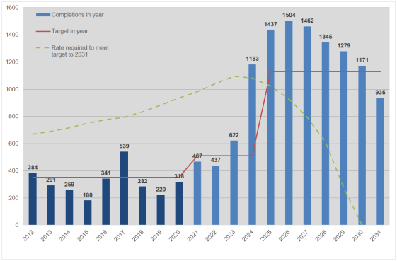
Reason/Source for Further Modification
As above
(18) FM 190
Page 222, Before Paragraph 14.30
Modification
|
Policy IMR2: Local plan early review |
|
The Council will undertake a whole plan review of the Local Plan 2011-2031 by the end of 2023 at the latest. This will determine whether this Plan needs to be updated either in whole or in part. All policies will be reviewed but with particular regard paid to the following matters that were specifically identified during the preparation and examination of this plan:
The review will have regard to up-to-date information and be conducted in line with Government policy and statutory requirements. Subject to the outcomes of that review, a new plan or policies will be prepared to a new time horizon of at least 2041.
The review will also serve to build upon existing strong, working relationships with adjoining and nearby authorities and may result in the preparation of a joint plan or policies based upon wider functional geographies. |
Reason/Source for Further Modification
To ensure the Plan is positively prepared and effective following the Matter 22 hearings and as supported by documents including ED176, ED178 and ED191B
(2) FM 191
Page 222, Paragraph 14.30
Modification
The Government expects plans to be regularly reviewed , preferably every five years155 and we will need to update our Local Plan more regularly than has happened in the past. National guidance recognises that plans can be reviewed in whole or in part to respond flexibly to changing circumstances156. We will use the monitoring framework, set out above, to keep the effects of this Plan under review.
Footnote
155 As set out in the Government's Technical consultation on implementation of planning changes (DCLG, 2016) Regulation 10A of the Town and Country Planning (Local Planning) (England) Regulations 2012 (as amended)
Reason/Source for Further Modification
For effectiveness in response to Inspector's August 2019 letter (Paragraph 25)
(3) FM 192
Page 224, Paragraph 14.32
Modification
In addition to our monitoring, we recognise that other events may trigger a future review of the Plan. local plans should normally set out where development will occur over a 15-year period from the point of adoption157. This Plan shows how we will meet our needs over the period to 2031, 13 10 years from the anticipated date of adoption.
Reason/Source for Further Modification
For effectiveness and in response to the Inspector's August 2019 letter (Paragraph 10)
(4) FM 193
Page 224, Paragraph 14.33
Modification
We already recognise that further work is required to ensure we meet our needs in full in the period beyond 2026. However, we believe that, due to the progress already made on these issues, the approach set out in this Plan is the most appropriate one for North Hertfordshire. Policy IMR2 therefore commits to an early, whole plan review to commence by the end of 2023 that will allow the Council to consider longer-term requirements, including in relation to a number of specific issues identified through the production of this plan.
Reason/Source for Further Modification
To ensure the Plan is positively prepared and effective following the Matter 22 hearings and as supported by documents including ED176, ED178 and ED191B
(3) FM 194
Page 224, Paragraph 14.36
Modification
At the same time, future decisions by other bodies may significantly influence future options for growth in North Hertfordshire. We will continue to work with central government, the Hertfordshire Growth Board and other relevant agencies to better understand the likely nature of these potential projects158.
Reason/Source for Further Modification
To ensure the Plan is positively prepared and effective following the Matter 22 hearings and as supported by documents including ED176, ED178 and ED191B
(5) FM 195
Page 224, Paragraph 14.37
Modification
We currently consider it most likely that The outcomes of these deliberations and the new settlement process will be reflected in a full the review of the Plan process outlined in Policy IMR2. We currently consider it most likely that this review will result in a need to comprehensively update the local plan, recognising that this cannot be prejudged at this time. Our present intention is that the next full any comprehensive review of this Plan will be completed by the mid-2020s at the latest. It will roll the Plan forward to a new time horizon of at least 2041 and deliver any specific additional land or updated policies and sites that we already recognise will be that are identified as being needed.
Reason/Source for Further Modification
To ensure the Plan is positively prepared and effective following the Matter 22 hearings and as supported by documents including ED176, ED178 and ED191B
(5) FM 196
Page 224, Paragraph 14.41
Modification
Beyond these defined events, there may be changes in circumstances that we cannot currently foresee , or are yet to understand the full implications of, but which have a substantial impact upon the District. This might be a major change to the way in which the planning system operates , as suggested in the Government's 2020 White Paper, or the cancellation of a key project required to support growth structural changes to the population or the way we live, work or spend our leisure time in response to Brexit, Covid-19, climate change or any other future event. We will determine the most appropriate response as and when any such circumstances arrive. It is anticipated that the review process outlined in IMR2 will be the most appropriate means of considering these matters but the Council may also consider focussed reviews of individual or small groups of policies prior to this where necessary.
Reason/Source for Further Modification
To ensure the Plan is positively prepared and effective following the Matter 22 hearings and as supported by documents including ED176, ED178 and ED191B
Examination Documents
(7) ED170 NHDC response to Inspector 9 August 2019 letter
(1) ED171 NHDC response to Inspector 9 July 2019 Letter - Paper A (OAN)
(11) ED172 NHDC response to Inspector 9 July 2019 Letter - Paper B (Green Belt)
(5) ED173 NHDC response to Inspector 9 July 2019 Letter - Paper C (East of Luton)
ED174 NHDC response to Inspector 9 July 2019 Letter - Paper D (West of Stevenage)
(88) ED175 NHDC response to Inspector 9 July 2019 Letter - Paper E (Additional land)
ED177 NHDC response to Q6 Inspector's letter 9 8 19 and SoCG with HCC redacted
ED178 NHDC Updated 5 Year Housing Land Supply Paper
(7) ED191A NHDC Response to Inspector's letter ED190
(4) ED215 NHDC note on Matter 22 (Housing Supply) and the buffer
(527) ED224 SOCG re housing need and delivery in Luton BC
(2) ED228 North Herts Local plan Matter 25 Gypsy and Traveller provision