Barkway and Nuthampstead Neighbourhood Plan 2018 - 2031
6 APPENDICES
1. Policy Process Map
Table showing how key objectives of the plan are linked the planning policies.
-
Key Objective
Policies that achieve the Key Objectives
1
To ensure that new development, including infill development, within or adjacent to and outside site allocations, is well designed and sympathetic to its surroundings in terms of style, layout and design, and benefits the community.
Policy BN H1 Affordable Housing
Policy BN H2 Design and Layout
Policy BN H3 Sustainable Construction
Policy BN H4 Design Codes
Policy BN H5 Framework for BK3
Policy BN H6 Infill Development
Policy BN H7 Extensions, Outbuildings and Garages
Policy BN H8 Backland Development
Policy BN E1 Preserving and Developing Local Employment Opportunities
2
To preserve the character, appearance and settings of all designated and non-designated heritage assets in Barkway and Nuthampstead, including those within and outside the boundaries of the conservation area.
Policy BN H2 Design and Layout
Policy BN H3 Sustainable Construction
Policy BN H4 Design Codes
Policy BN H5 Framework for BK3
Policy BN H6 Infill Development
Policy BN H7 Extensions, Outbuildings and Garages
Policy BN H8 Backland Development
Policy BN NE4 Important Views
Policy BN HA1 Designated Heritage Assets
Policy BN HA2 Non-Designated Heritage Assets
Policy BN HA3 Barkway Conservation Area
3
To promote biodiversity by protecting green spaces within the parish and support ecosystem services by ensuring new builds are as eco-friendly as possible.
Policy BN NE1 Local Green Space
Policy BN NE2 River Quin Protection
Policy BN NE3 Conserve and Enhance Biodiversity
Policy BN H3 Sustainable Construction
Policy BN L4 Protected Recreational Open Space
4
To increase opportunities to foster a sense the community through the development, preservation and maintenance of community facilities.
Policy BN L1 Valued Community Assets
Policy BN L2 Existing Pubs
Policy BN L3 Development of the Community Hub
Policy BN L4 Protected Recreational Open Space
Policy BN I1 Spending Priorities
5
To promote access to nature through preserving and creating footpaths, cycle routes and bridleways leading to the countryside, and their settings.
Policy BN NE1 Local Green Space
Policy BN NE3 Conserve and Enhance Biodiversity
Policy BN T4 Safe and Accessible Walking and Cycling Routes
Policy BN I1 Spending Priorities
6
To have a sustainable local economy through the preservation and creation of local employment opportunities.
Policy BN E1 Preserving and Developing Local Employment Opportunities
Policy BN E2 Internet Infrastructure
Policy BN L3 Development of the Community Hub
7
To improve road safety throughout the Parish especially at several potentially dangerous road junctions, and to develop safer routes between settlements.
Policy BN T1 Sustainable Transport Provision
Policy BN T2 Mitigating Traffic Impact
Policy BN T3 Public Rights of Way
Policy BN T4 Safe and Accessible Walking and Cycling Routes
Policy BN T5 Vehicle Parking in Residential Development
8
To support local educational institutions.
Policy BN T4 Safe and Accessible Walking and Cycling Routes
9
To promote health, wellbeing and sustainability in the villages and their communities.
Policy BN L1 Valued Community Assets
Policy BN L2 Existing Pubs
Policy BN L3 Development of the Community Hub
Policy BN L4 Protected Recreational Open Space
10
To preserve the important views within and around the parish.
Policy BN NE4 Important Views
Policy BN NE5 Chestnut Avenue Protection
2. Local Green Space Evidence
The following photographs demonstrate the variety of LGS being designated.
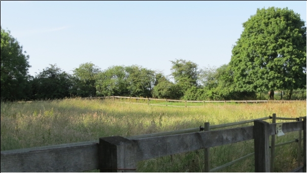
L1: Forest school site
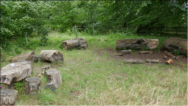
Figure 16: Photograph of Local Green Space L1
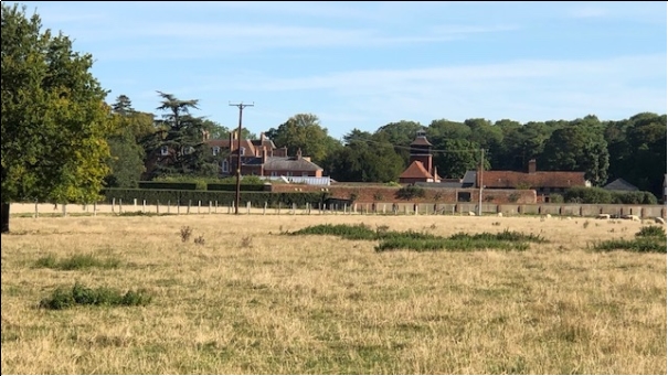
L2: Field to the west of Rushing Wells
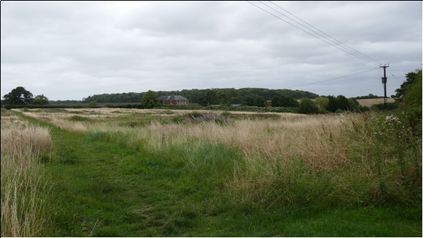
Figure 17: Photograph of Local Green Space L2
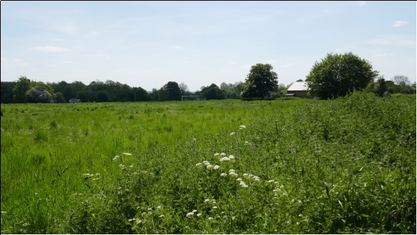
L3: Manyon's Field including Withy Grove
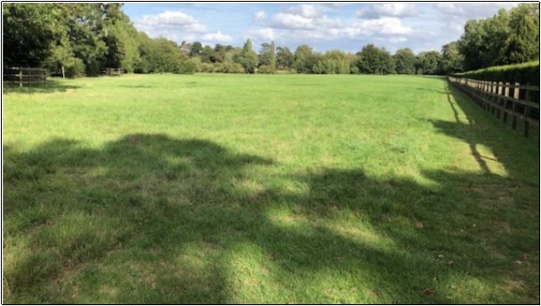
Figure 18: Photograph of Local Green Space L3
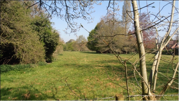
L4: Carriage Wash and adjoining grass verge
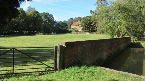
Figure 19: Photograph of Local Green Space L4
L5: Barkway village pond
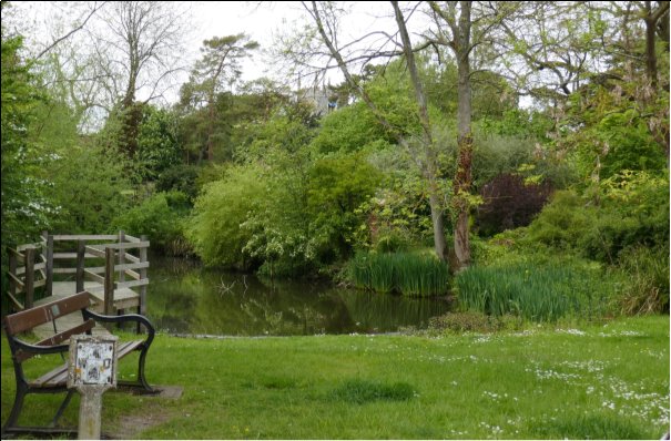
Figure 20: Photograph of Local Green Space L5
L6 Land encompassing Three Roods Lane
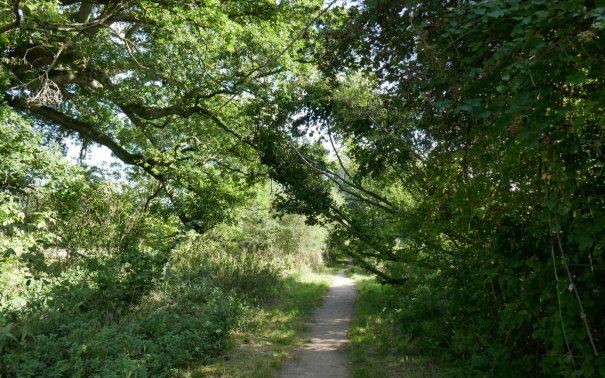
Figure 21: Photograph of Local Green Space L6
L7 Wheatsheaf Meadow Garden
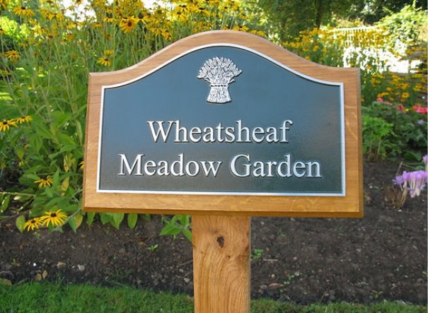
Figure 22: Photograph of Local Green Space L7 (courtesy of Village Sign People)
L8 Land behind Windmill Close
Figure 23: Photograph of Local Green Space L8
L9: Grove at Caylers Farm, Nuthampstead
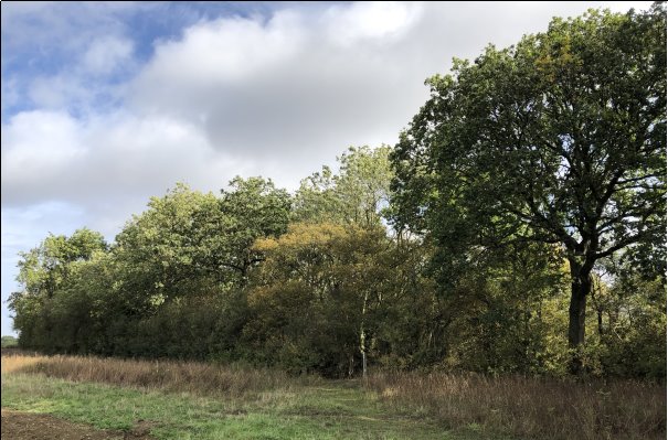
Figure 24: Photograph of Local Green Space L9
Detailed Maps of Local Green Space Designations
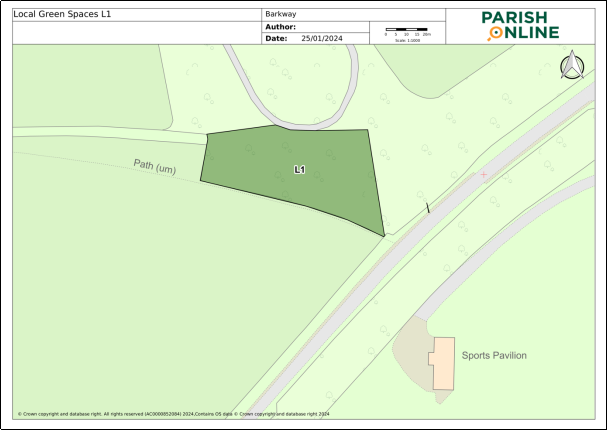
Figure 25: Detailed Map of Local Green Space L1
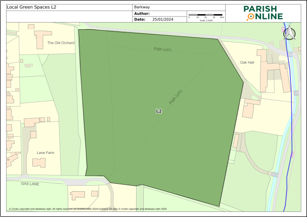
Figure 26: Detailed Map of Local Green Space L2
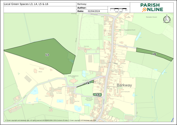
Figure 27: Detailed Map of Local Green Spaces L3, L4, L5 & L6
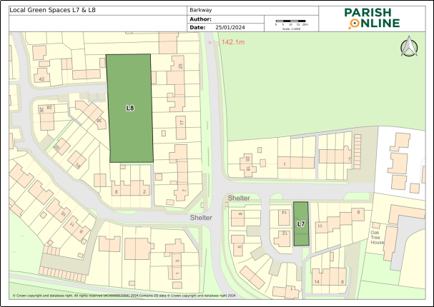
Figure 28: Detailed Map of Local Green Spaces L7 & L8
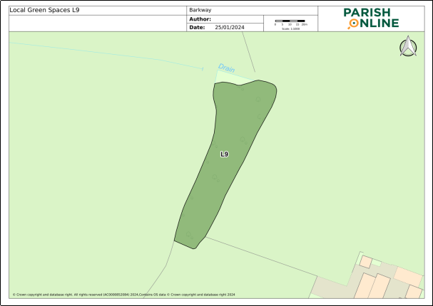
Figure 29: Detailed Map of Local Green Space L9
Local Green Space Descriptions
The following descriptions provide a sense of the purpose of each local green space and what makes it special to the community, hence qualifying its designation.
L1 Barkway School Forest Classroom, Cambridge Road, Barkway
Grid Reference: TL387363. Site size: 0.31ha
The forest classroom is a fenced green area of broadleaf woodland, with clearings made to accommodate natural seating formed from felled logs. Located on the northern edge of Barkway village, it adjoins Newsells Stud. It lies adjacent to a site with planning permission for 140 new homes.
The area provides a special amenity for children to learn about and appreciate nature. It was loaned to Barkway School, by the owners of Newsells Stud (to whom the land belongs) to be used as an outdoor classroom, enabling the children to study the flora and fauna of the area. A larger number of children now benefit from what the site has to offer since the federation of Barley and Barkway schools. It is a quiet spot.
L2 Field to the west of Rushing Wells, adjacent to Gas Lane, Barkway
Grid Reference: TL38635. Site size: 3.43ha
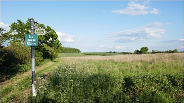
The field is broadly rectangular in shape and has reverted to unmanaged meadow, criss-crossed by a single public footpath and several tracks. It lies at the southern end of the village and is a popular and accessible route for dog walkers and hikers alike.
In the field's current condition wildlife has flourished including badgers, foxes, muntjac deer, a variety of insect life including many species of butterfly and moth, huge numbers of field voles and the birds which predate them: barn owls from at least two separate nesting sites which trawl the fields at dusk looking for prey, and in the daytime kestrels, kites and buzzards. The volume of species on the site makes it of particular interest.
L3 Manyon's Field including Withy Grove
Grid Reference:TL381357. Site size: 3.1ha
A large area, broadly triangular in shape, Manyon's Field is a well-maintained meadow, mown to enable walkers to access the two footpaths that run through it. It lies just off Church Lane, with its south-eastern corner bordering the churchyard of historic St Mary Magdalene Church and with a view of both. Withy Grove lies in the northern corner of the field and comprises a stream and willow grove fed from the source of the River Quin (an important chalk stream) in Rokey Wood to the west of the site.
Once a year, the field becomes part of the infrastructure for Barkway's celebrated Street Market, offering parking for the thousands of visitors to the event. This and the care taken of the field by the owners of the land mean it is a major community asset.
L4 Carriage Wash and adjoining grass verge
Grid reference:TL383355 Site size: 0.05ha
The Carriage Wash and the adjoining grass verge which borders Church Lane, offers an excellent view of the church, and of the Grade II listed Manor Farm House, across Manor Farm paddock (See Figure 11 and Figure 19).
The Carriage Wash is of great historical interest, dating from c1600. It is believed to have begun as a carriage wash catering to the needs of the thriving coaching trade which ran through Barkway from London to points further north. It continued as a carriage and wagon wash, servicing local agricultural vehicles well into the twentieth century. The site lies in the heart of the village and is now home to a thriving population of ducks and aquatic life, including hundreds of toads in the breeding season and great crested newts.
L5 Barkway village pond
Grid reference: TL382366. Site size: 0.06ha
Barkway village pond is situated in the centre of the village on the High Street in front of a grassed area with seats and a village sign which depicts the village's coaching heritage. The pond is next to the village school and the area provides a meeting point for those parents waiting for their children at the end of the school day, as well as offering a beautiful tranquil area in which to rest. The pond is well maintained and is set amongst overhanging trees with native species of water marginal plants along its perimeter.
A wooden jetty extends from the grass along one side of the pond and enables the children to go pond dipping and observe the wildlife in safety. The pond is home to several different species of fish and amphibians which are easily visible from the jetty along with nesting waterfowl. To the rear of the pond, there are views of the Tudor manor house and the church framed by the trees. The pond is mentioned in the deed of 1630, when it was given to the village along with surrounding buildings, and since when it has provided a water source for travelling animals.
L6 Land encompassing Three Roods Lane
Grid reference: TL386357. Site size: 0.33ha
Three Roods Lane runs from Barkway High Street to open fields some 150 metres further along, widening out at the end to reveal a vista of Earl's Wood. The track is a well-maintained public footpath, (ROW) but the land on the margins of the footpath has remained untouched and unchanged. These areas area a textbook of English hedgerow plants, flowering and fruiting according to the season and attracting the full range of native bird and animal life. A magnificent veteran oak tree spreads its branches halfway along the path – and marks a change in the profile of the landscape as wide, shallow ditches which flood in winter appear on each side, turning the path into a causeway. The lane forms a part of a unique landscape of streams, ponds, culverts and ditches, many hidden, which characterise the parish of Barkway.
Nowadays the path acts as a link between the centre of the busy High Street and the fields and footpaths which cross the Cokenach Estate, attracting hikers, runners and dog walkers. It is also of historical significance. The names Three Roods Lane and its alternative, Lower Stow Pightle, are of Anglo Saxon origin, the former being a measurement of acreage and the latter a small enclosure once part of a larger field. Three roods equate to ¾ of an acre, which is almost exactly the size of the modern lane and its margins. It is likely that the lane formed the route for labourers to reach their work in the fields beyond in previous centuries.
L7 Wheatsheaf Meadow Garden
Grid reference TL383360. Site size: 0.03ha
The garden is situated in the heart of the housing community at the northern end of Barkway, bordering the Royston Road. Built on the site of Wheatsheaf Meadow House which had provided accommodation for the elderly, the garden was created as a 'village garden' to promote interaction between the youngest and oldest members of the community. Designed by children from the village school, the garden is divided into three sections with connecting pathways, planting and seating.
Although small, the site is a tranquil space, with a sense of seclusion which has fulfilled its purpose of providing for all ages within the community.
L8 Land behind Windmill Close
Grid Reference TL382366. Site size: 0.22ha
This green space, originally arable land and very much larger, has since the 1980's been populated with new housing around its perimeter. By 1991 the land was enclosed by housing and left fallow. A proposal by the council to sell the land for development was contested and a case was successfully made by residents to safeguard a portion of the land to provide a green lung in an urban setting. It is registered as an open space. Rectangular in shape, the majority of the area is grassed, with some mature trees in the middle and contained rewilded areas on the margins. It is well maintained, with picnic seating and other equipment.
Historically, the area has been used as a safe enclosed space in which children from Royston Road and Windmill Close can play and continues to be so, where parents need not worry about them crossing the busy road to reach the recreation ground. Barbecues, various jubilee celebrations and other social events are held here for everyone, and the area also provides a quiet spot in which all ages can relax. It reinforces the strong sense of community felt in this part of Barkway as many residents have close family ties across many generations with Barkway and surrounding areas.
L9 Grove at Caylers Farm, Nuthampstead
Grid reference: TL408348. Site size: 0.33ha
This small grove lies 200 metres from Bell Lane in Nuthampstead to the west of Caylers Farm buildings. It is a beautiful copse of mature native woodland trees, bisected by a public footpath leading from Caylers Farm to the Hertfordshire Way. It is a feature of the countryside separating upper and lower Nuthampstead.
It is a haven for local wildlife including magnificent birds of prey, notably buzzards and red kites. It is close to the starting point of a popular walk, especially favoured by dog walkers, from Nuthampstead village, linking Nuthampstead with both the Cokenach Estate and the bluebell woods at Morrice Green. The grove can be readily admired from the heart of the village and its ever-changing foliage marks the passage of the seasons for the whole community.
Local Green Space Assessment
The following tables evidence the assessment of the Local Green Spaces designated in this Plan.
|
Site description |
No |
Potential development site |
Other designation |
Common or Village Green |
Garden |
Planning Application |
|
Barkway School Forest Classroom |
L1 |
No |
Part priority habitat |
No |
No |
No |
|
Field to the west of Rushing Wells |
L2 |
No |
Restricted Byway 010 |
No |
No |
No |
|
Manyon's Field Incl. Withy Grove |
L3 |
No |
Footpaths 003 & 004 & adj to LWS |
No |
No |
No |
|
Carriage Wash and adjoining grass verge |
L4 |
No |
Grade II listed building |
No |
No |
No |
|
Village Pond |
L5 |
No |
No |
No |
No |
No |
|
Land encom-passing Three Roods Lane |
L6 |
No |
Footpath 014, adjacent to LWS |
No |
No |
No |
|
Wheatsheaf Meadow Garden |
L7 |
No |
No |
No |
No |
No |
|
Windmill Close |
L8 |
No |
Recreational Open Space |
No |
No |
No |
|
Grove at Caylers Farm |
L9 |
No |
No |
No |
No |
No |
|
Site description |
No |
Size (ha) |
Local in Character |
Extensive Tract of Land |
Very Special to the Community |
Close to the Community it Serves |
|
Barkway School Forest Classroom |
L1 |
0.31 |
Yes |
No |
Yes |
Yes |
|
Field to the west of Rushing Wells |
L2 |
3.43 |
Yes |
No |
Yes |
Yes |
|
Manyon's Field Incl. Withy Grove |
L3 |
3.1 |
Yes |
No |
Yes |
Yes |
|
Carriage Wash and adjoining grass verge |
L4 |
0.05 |
Yes |
No |
Yes |
Yes |
|
Village Pond |
L5 |
0.06 |
Yes |
No |
Yes |
Yes |
|
Land encom-passing Three Roods Lane |
L6 |
0.33 |
Yes |
No |
Yes |
Yes |
|
Wheatsheaf Meadow Garden |
L7 |
0.03 |
Yes |
No |
Yes |
Yes |
|
Windmill Close |
L8 |
0.22 |
Yes |
No |
Yes |
Yes |
|
Grove at Caylers Farm |
L9 |
0.33 |
Yes |
No |
Yes |
Yes |
|
Site description |
No |
Attractiveness of Site |
Historical Signifi-cance |
Recreation Use |
Tran-quility |
Wildlife |
|
Barkway School Forest Classroom |
L1 |
Forested area |
No |
Amenity for children to learn about nature |
A quiet spot |
All species indigenous to locality |
|
Field to the west of Rushing Wells |
L2 |
Unmanaged meadow |
No |
A footpath runs diagonally across |
No |
Haven for wildlife inc. owls & badgers |
|
Manyon's Field Incl. Withy Grove |
L3 |
Provides a vista of the historic church |
Provides a vista of the historic church |
Contains two public footpaths. Used for village events |
A quiet spot |
Not known |
|
Carriage Wash and adjoining grass verge |
L4 |
Provides a vista of Manor Farm and Church |
Carriage Wash c1600 Grade 2 listed |
Watching the ducks |
A quiet spot |
Habitat for toads and great crested newts |
|
Village Pond |
L5 |
Framed by trees and with a vista of the church. Meeting point with seat. |
Given to the village by deed in 1630 for watering animals |
A jetty allows access for pond dipping |
On main road |
Fish, amphib-ians and ducks breed here |
|
Land encom-passing Three Roods Lane |
L6 |
Natural woodland |
Lane's names are of Saxon Origin |
Footpath provides access to fields for walkers |
A quiet spot |
Adjacent to Local Wildlife Site |
|
Wheatsheaf Meadow Garden |
L7 |
Designed as a community garden by Barkway School children |
No |
Used by young and old for recreation |
No |
Not known |
|
Windmill Close |
L8 |
Enclosed green space in which children can play safely |
No |
Used by all generations for recreation |
A calm space |
Not known |
|
Grove at Caylers Farm |
L9 |
Copse of mature native woodland linking other local beauty spots |
No |
Part of a popular walk |
A quiet spot |
A haven for wildlife including buzzards and kites |
3. Local Sites of Environmental Interest
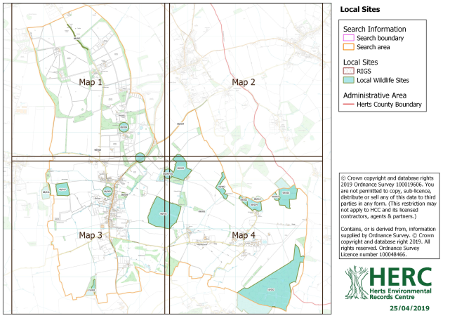
4. Hertfordshire Ecological Network Mapping
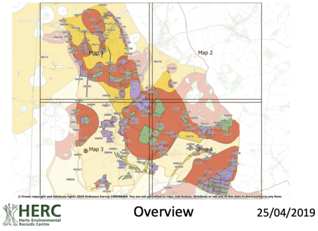
Green areas on the map contain habitats listed within S41 of the NERC Act and should be avoided by development. Adjacent or surrounding development should provide for the enhancement of these habitats through ongoing positive conservation management. A data table that is available on request identifies the habitat type that must be maintained.
Purple areas on the map contain habitats not currently qualifying under S41 of the NERC Act but with high potential to do so. Whilst not receiving the same level of statutory and policy-based protection as the green areas, they should nonetheless be avoided by development. This is because they are important components of ecological networks, and it is much quicker, less risky and more cost-effective to restore these habitats than to create new ones elsewhere.
Orange (red)/yellow/cream areas on the map contain no mapped existing habitats of any significance. Therefore, in the context of the ecological networks dataset, these areas are suitable for appropriate development. These areas also form the potential for new habitat corridors to be created to improve ecological network integrity.
5. Important View Evidence
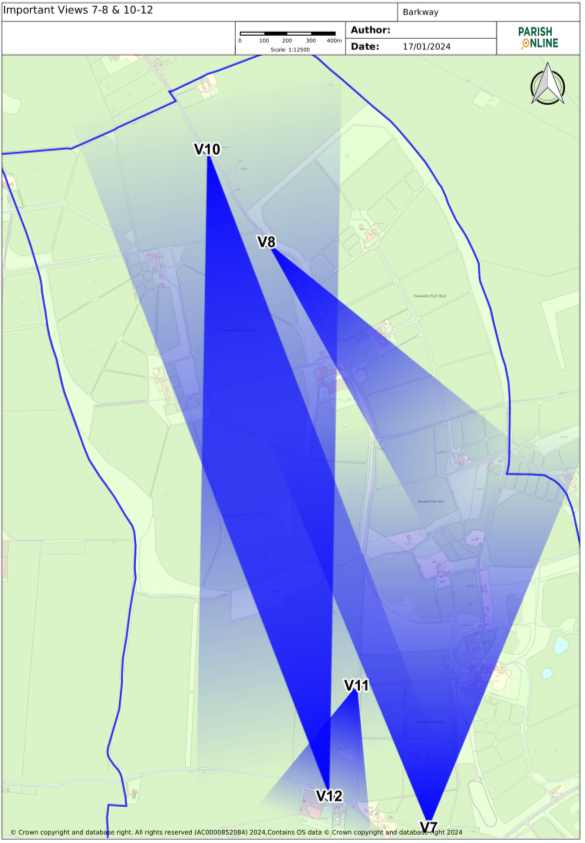
Figure 30: Map of Important Views 7-8 & 10-12
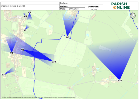
Figure 31: Map of Important Views 2-6 & 13-15
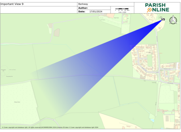
Figure 32: Map of Important View 9
V1: View from Three Roods Lane across the paddock behind The Red House
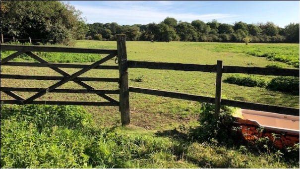
Description of View from Three Roods Lane across the paddock behind The Red House
This small meadow faces north towards the recreation ground and is bordered by the River Quin, distant views of mature hedgerows, and two ancient footpaths. It is used for the grazing of ponies and horses. To the west of the field lies one of the most significant houses historically in the village, the Red House. There is evidence of Neolithic settlement in adjoining fields.
The gate and fence in the foreground provide a visual gap in this otherwise enclosed field. The public footpath running along the southern side of the field is used by dog walkers, runners and hikers alike and this was once a major access route from the village to the Cokenach Estate where many of the villagers worked in the fields. The footpath used to be wide enough for the local baker's van to drive up and it opens onto the High Street next to The Coach House adjoining The Red House.
V2: View north from Earl's Wood to Cokenach
Description of View north from Earl's Wood to Cokenach
The view is north to the house and grounds of the Cokenach Estate from the edge of Earl's Wood. The meadow in the foreground provides a setting for the house and is used to graze sheep.
An ancient droveway, now a public footpath, from which this picture was taken, runs along beside the woodland. Cokenach is a sixteenth century country estate (listed Grade II* house) in the grounds of which lie the remains of an early 18th century formal garden set within 111 acres of parkland. The owners of this heritage asset are committed to protecting endangered areas and the wildlife which inhabits them.
Earl's Wood itself is an ancient wood of oak, ash and maple with carpets of wildflowers (bluebells, primroses, cowslips and wood anemones, for example) in the spring.
V3: View south to Recreation Ground
Description of View south to Recreation Ground
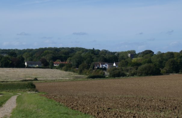
Taken from the B1368 heading south towards the village. Following your passage through a natural colonnade of chestnut trees, your journey into the village from the north opens up to a view of this natural wildlife meadow, which forms a link between the Cokenach Cricket Club and Barkway Recreation Ground, the buildings and football posts of which can just be seen to the left of the photograph. The movement from the relative shade of the chestnut trees to the open vistas afforded by the meadow provides a visual expanse before narrowing once more on entry to the High Street.
V4: View of Manor Farm southern field
Description of View of Manor Farm southern field
Taken from the public footpath, looking north towards Manor Farm and grounds and St Mary Magdalene Church. The footpath runs along the southern edge of the field, connecting the High Street with Reed and Buckland villages.
Framed by the trees and hedgerows planted by generations of owners of Manor Farm, the tower of Grade 1 listed St Mary Magdalene Church can just be glimpsed in the background rising from between the foliage. Grade 2 listed Manor Farm itself, is set to the left of the church, and between them, these two buildings lie at the heart of the village and form a significant part of its historic character.
V5: View from Social Club across meadow
Description of View from Social Club across meadow
A view across the small meadow between Barkway Social Club and Barkway Village Hall on the northern outskirts of the village on the road to Barley. This charming meadow is grazed by ponies and forms a green link between two important, well-used community assets giving a real rural feel to this approach into the village. It's also a favourite with the children who like to pet the ponies!
V6: View over field towards the River Quin and Earl's Wood
Description of View over field towards the River Quin and Earl's Wood
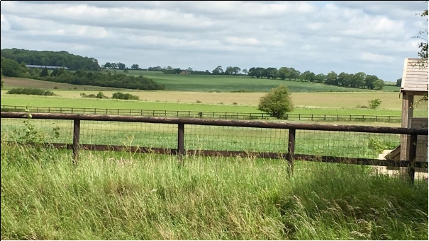
A view from the junction of Burrs Lane and the road to Rushing Wells. This field lies to the east of the High Street and provides a visual expanse looking across towards Earl's Wood on the left and in the far distance the village of Nuthampstead.
This beautiful rewilded field provides a feeling of openness, and uninterrupted vistas across miles of arable and wooded landscape. At its eastern margin lies the River Quin, a chalk stream of national importance. Lying at the junction of two public footpaths, one of which is part of the Hertfordshire Way, and with an additional track running across it, this is an important field for dog walkers and hikers as well as being particularly rich in wildlife, most notably some of the less common birds of prey such as owls and kestrels and several lesser known species of butterfly.
V7: View from Bridleway 18 towards Newsells
Description of View from Bridleway 18 towards Newsells
Bridleway 18 lies at the top of the chalk escarpment known as the Chiltern Extension or East Anglian Heights at the northern end of Barkway.
Known for its vast skies, this view is the highest point in the village and commands unparalleled, distant views across Newsells Stud to Cambridge and Ely (on a clear day). It is typical of the uninterrupted views lying along the 'Joint', the road joining Barkway and Reed.
The visual expansiveness of this vista contrasts with the predominantly enclosed meadows and arable fields on the outskirts of the remaining three sides of the village, and the area offers an exhilarating place in which to ride or walk.
V8: View of Newsells Stud from Whitely Hill
Description of View of Newsells Stud from Whitely Hill
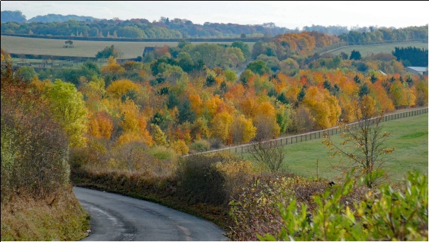
The road northwest towards Royston from Barkway winds through land owned by Newsells Stud, an important breeder of thoroughbred horses and Barkway's biggest employer. The owners undertook a major landscaping project, planting over 70,000 trees in order to enhance the privacy of its property. This has resulted in a spectacular view in all seasons and particularly stunning autumn displays such as the one pictured.
Looking south from Whitely Hill in Autumn provides a view you do not get in any other place: a riot of colour as the trees on either side of the road mimic the seasonal vista of the Fall in New England. At the top of the hill, the remains of a Saxon settlement exist, which the road bisects, and it is easy to see why this vantage point would be chosen as a place to make camp as it provides a visual connection between the highlands of the escarpment and the lowlands of the fens.
V9: View across Duke's Field towards Rokey Wood
Description of View across Duke's Field towards Rokey Wood
This field lies to the north of the village, beyond the developments of new housing near the Royston Road, and looks out over Rokey Wood in the distance, an ancient woodland of national significance. The field has been maintained as a wildflower meadow and in summer provides a frontage to the woodland beyond.
Rokey Wood is archaeologically important, as a Roman Hoard was found there in 1743 which now resides in the British Museum. It links Barkway to the A10 some miles further west which, as the Roman road Ermine Street, ran all the way to York. As well as its historic significance, Rokey Wood provides spectacular displays of bluebells and hosts abundant wildlife.
V10: View of Barkway Mast
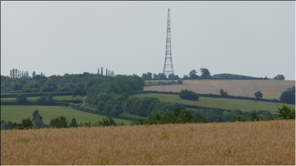
Description of View of Barkway Mast
Barkway radio mast stands at the junction of the Royston Road and the Reed Joint on the edge of the Chiltern Escarpment. It is visible for many miles away to the north and east and is an iconic, local much-loved landmark.
The mast defines Barkway's history and sets it apart from other North Hertfordshire villages, having been part of the US Airforce communications network from 1942. Sold to the RAF in 2011, it stands as a memory of the strategic importance of this area to the war effort. Popular local belief is that it was also a relay station for the hotline between Moscow and Washington.
V11: View of Chiltern Escarpment and Chalk Pit
Description of View of Chiltern Escarpment and Chalk Pit
This view looks out east along the Chiltern Escarpment just north of Barkway, along which runs the ancient Icknield Way, with entry to a historically important chalk pit in the dip where the photo is bisected by cornfield and meadow.
The small pit has been designated a regionally important geological site by the Hertfordshire RIGS Group and is currently the subject of a special scientific investigation (SSSI) owing to sitings of at least seven red and amber listed birds in recent years.
V12: View north towards Cambridgeshire from Reed Joint
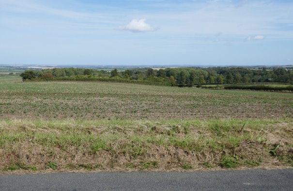
Description of View north towards Cambridgeshire from Reed Joint
This view looks northwards from Reed Joint to Cambridgeshire and the fens. The verge is low, providing a frontage to what is the 180 degree vista looking out from the Chiltern Escarpment. The high point of the landscape, this photograph clearly shows how the land slopes down from here and is only punctuated by stands of trees and mature hedges. The photograph depicts a bleak place to stand in winter, but this is more than compensated for by the dramatic vista, unchanged since Celtic times.
V13: View from Buckland Road east towards High Street, Barkway
Description of View from Buckland Road east towards High Street, Barkway
This view is the approach to the southern end of Barkway on the Buckland Road. It emerges on to the B1368 opposite The Tally Ho pub.
Behind the long stand of mature trees, a fallow field lies alongside a chicken farm. Both areas are host to herds of deer which choose to shelter there at night. A small road runs alongside the trees and leads to arable fields with tracks frequented by hikers, riders and dog walkers. A whole network of walks, to Reed and Buckland, originate from this point. The presence of the chicken farm does not detract from the rural feel of this approach to the village and the tunnel effect of the trees at the end of the road is a welcome contrast to the exposed Buckland Road, so characteristic of the western extremities of the village.
V14: View from Earl's Wood towards the River Quin
View from Earl's Wood west towards the River Quin
This view to the village is taken from the western corner of Earl's Wood and shows a meandering track leading down to the banks of the River Quin. It is notable for the way in which it shows the village nestling in amongst the trees on the other side of the river. The tower of St Mary Magdalene Church rises above the trees and some of the older houses on the High Street can be glimpsed through the green. It gives the sense of a contained settlement and permanence, which is appropriate, as evidence of neolithic occupation has been found in the field to the right of the picture.
V15: View from Bell Lane towards Cokenach
View from Bell Lane towards Cokenach
This is a panoramic view of farmland taken from Bell Lane in Nuthampstead looking north to the Cokenach Estate.
The view illustrates the visual expanse of the agricultural land in this area of North Hertfordshire and the variety of its uses, from the paddock in the foreground, to intensively farmed arable fields framed by mature trees and hedging, and meadow land bisected by the Hertfordshire Way, the principal footpath of the county. A glance behind you will reveal a 16th century thatched and boarded cottage, typical of the village in which it stands.
Summary Assessment of Important Views
|
Important View |
Type |
Justification & Importance |
|
V1 – View northeast from Three Roods Lane |
Mid-distance rural view |
Paddock vulnerable to backland development, potentially extending up to the recreation ground to the north and the field to the south of Three Roods Lane (which has been subject to a previous, unsuccessful planning application). |
|
V2 – View north from Earl's Wood to Cokenach |
Mid-distance view focused on central buildings |
Any development in the meadow would obscure the view of this Grade II* listed building and designated Historic Park and Garden from the footpath. and could negatively impact on the significance of the heritage assets. |
|
V3 – View south to recreation ground |
Mid-distance rural view |
This view is critical to the setting and character of the village. It lies adjacent to Cokenach Historic Park and could impact on its setting. |
|
V4 – View of Manor Farm southern field |
Mid-distance view |
Your eye is drawn to the church tower, just left of centre. In the Conservation Area Character Statement, the 'land around Manor Farm' and the 'open views around Manor Farm' were noted as worthy of conservation. |
|
V5 – View from social club across meadow |
Mid-distance rural view |
Potential pressure on this meadow which is adjacent to a large site allocation for housing in NHDP but feel of openness should be retained on the edge of the village. |
|
V6 – View over field towards the river & Earl's Wood |
Long-distance rural view |
View provides visual connections from the village (High Street) to the open countryside, ancient woodland and the River Quin. |
|
V7 – View from Bridleway 18 towards Newsells |
Very long-distance rural view |
View is typical of the uninterrupted views north all the way along the "Joint", the road joining Barkway and Reed, taken from the highest point in the village, known for its vast skies without light pollution. |
|
V8 – View of Newsells Stud from Whitely Hill |
Long distance rural view |
Future development at the stud farm should respect the special character of this view, which should remain dominated by the tree canopy. |
|
V9 – View across Duke's Field towards Rokey Wood |
Mid to long-distance rural view |
A previous planning application for 15 houses on Duke's Field site was refused, and dismissed on appeal, on the grounds of unsustainability and damage to the view. |
|
V10 – View of Barkway Mast |
Long-distance iconic view |
The mast is close to the ancient chalk pit and unites ancient and modern history and Barkway's part in both. |
|
V11 – View of Chiltern Escarpment & Chalk Pit |
Mid-distance rural view |
Importantly links historic paths and economic activity whilst the foreground has returned to nature. It holds is a glimpse into the past. |
|
V12 – View north towards Cambridgeshire from Reed Joint |
Very long-distance rural view |
The uninterrupted visual expanse looking northwards is dramatic and unequalled in Barkway. |
|
V13 – View from Buckland Road east towards High Street, Barkway |
Mid-distance view |
Characteristic of the western edge of the village, an unseen chicken farm lies beyond the trees. The urbanisation of this view would be an unwelcome intrusion. |
|
V14 – View from Earl's Wood west towards Barkway |
Mid-distance historic view |
It gives a sense of a settlement contained in the trees, and of permanence, as though nothing has changed for generations. A legacy important to the community. |
|
V15 – View north from Bell Lane to Cokenach |
Mid to long-distance rural view |
There is a risk that planning applications for the residential re-use of agricultural buildings, (including those pictured) or for development in a rural area beyond the green belt could compromise the essential character of this panoramic view. |
Descriptions of Character Photos and Key Views from Barkway Conservation Area Character Statement 2019
The following descriptions are of the Character Photos and Key Views noted in the Barkway Conservation Area Character Statement 2019 on pages B1 to B12, the Key Views being identified by suffix KV, and all are identified on the map below.
B1
Looking east from the southern end of the High Street. 93/95 and 97 High Street were, in the late 15th century a Wealden house, possibly the oldest dwelling in the village. Next door, the little green house is an example of an end-on house which were often built to fill in spare spaces between larger buildings. The larger house to the left is Berg Cottage, owned by the National Trust.
B2
The flint wall, built in 1830, unsurprisingly, forms the boundary of Flint House at the northern end of the village looking west along the Royston Road. Flint is one of a great variety of building materials used throughout the centuries for houses along the High Street.
B3
Church Lane looking west towards St Mary Magdalene Church. The Carriage Wash on the left is an emblem of Barkway's coaching and agricultural history. Used to wash the wheels of carriages passing along this significant coaching route originally, it became a wagon wash and a place to refill traction engines as agriculture developed.
B4 (KV1)
This view from the junction of the High Street and Royston Road looking south demonstrates the wide variety of building styles and materials employed to build houses, from flint to red brick to plaster and render. The Red House (large house by tree on the left) has its own typical 'viewing point' for a big house on the opposite side of the road - a space designed to offer vistas uninterrupted by other dwellings to the most prosperous houses.
B5 (KV2)
The sweep of the road looking south gives a sense of space in this part of the village. The origins and uses of the buildings can sometimes be detected by the size of windows and frontages. Many dwellings were once shops, for example in this picture the white building in the foreground and number 26 which was a Victorian shop next to the Half Moon Ale House (Now Half Moon Cottage) The row of cottages in the background were once places to service the coaching trade, for example tanneries and saddleries and, along with the cottages at the entrance to Church Lane are all of Tudor origin.
B6 (KV3)
This lane leads out to the western margin of the conservation area. The Carriage Wash lies in the background on the left while the footpath leads to the churchyard. The landscape quickly changes from a busy High Street to the quiet, rural aspect of Church Lane. The north/south orientation of the village predominates, but the combination of church, manor house and vicarage on Church Lane to the west is considered to be by historians a classic village grouping.
B7 (KV4)
The tower of St Mary Magdalene, shown here from the western section of Church Lane is a landmark, visible from many parts of the village and beyond – and a focal point for village gatherings both temporal and spiritual. The restoration work taking place and shown in the photograph follows on from extensive repairs undertaken in 1861.
B8 (KV5)
This long stretch of road looks north towards the end of the village. Built in the late 16th century, The Old Forge on the right, is a good example of a timber framed house with jettying. The first house on the left was the old post office before it became a family home. A concentration of smaller cottages to left and right once housed the trades which serviced the village such as the slaughterhouse.
B9 (KV6)
The drive leading west to Manor Farm from the High Street in the centre of the village is bordered on one side by the village school and on the other, behind the hedge, the village pond. The school sits on the site of the old village market place and was built in 1838. Legend has it that a tunnel runs from the 1630's Town House on the opposite side of the road from the school along the driveway to Manor Farm. Sadly, this rumour has never been proved!
B10 (KV7)
This view, adjacent to numbers 88,90 and 92, looking south highlights how the houses front directly onto the street, giving a sense of enclosure. The concentration of houses along the road with fields behind was designed to make the village feel 'town-like.' New housing on the left, built on the site of the old brewery blends sympathetically with Cross Keys opposite, its name a legacy of its former use. Many houses in the village were once hostelries, from the very grand to the morally dubious, all serving the coaching trade! There were 7 very large coaching inns in the centre of the village clustered around Church Lane, almost all of which live on in the names of the houses they have become. One, The Angel, stabled 100 horses available to draw the carriages.
B11 (KV8)
This view looks north along the High Street from the entrance to Ashgrove. From the southern approach to the village to this point in the distance the road is straight and is bounded by the oldest building, the Wealden house in the middle-distance side by side with the newest brick and timber houses set back from the pavement.
B12 (KV9)
The southern entrance to the Conservation Area, shown in this photograph, begins with Barkway Cottage (hidden behind the hedge on the right) and a predominantly pastoral aspect, before giving way to Clockhouse Cottage on the left and next to Turnpike Cottage (just outside the photograph, obscured by the hedging), the first indication of the village's coaching heritage when time was flexible and clocks needed to be re-set to Barkway time as carriages travelled north. Clockhouse Cottage is set slightly at an angle to the road to make seeing oncoming coaches from the south easier.
6. Map Showing Heritage of Barkway Village
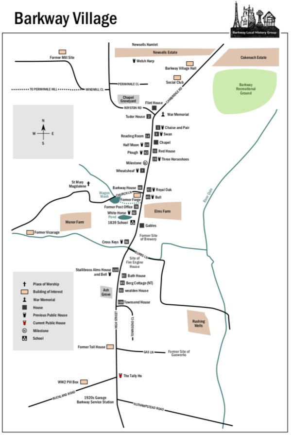
– Non Designated Heritage Assets Evidence
This appendix provides evidence of the local importance of the buildings, structures and the landscape that are included in the Plan as non-designated heritage assets.
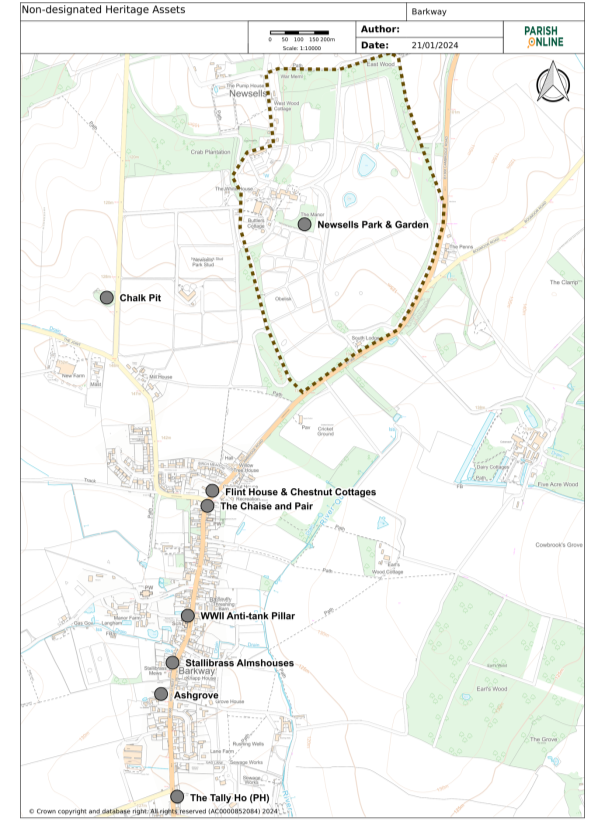
Figure 33: Policies Map Extract of Non-designated Heritage Assets
The Chalk Pit, Royston Road, Barkway
Grid Ref: TL38166
The Chalk Pit is a Regionally Important Geological / Geomorphological Site (RIGS) - RIGS are analogous to non-statutory biological sites of regional or local importance.
The Chalk Pit also has local historical significance. The pit was originally excavated to provide chalk for improving local farmland. Chalk extraction ceased in Victorian times and for a while it was used as a village rubbish dump. This explains the many Victorian glass bottles still found on the site.
The Historic Environment Record Number for the Chalk Pit is 31530. It is described as Post Medieval. In 1878 it had a track into the pit, a small rectangular building on the south side, and next to this a circular structure marked on OS maps as 'Limekiln'. These structures are no longer there.
The Chalk Pit is now a small (0.3) nature reserve of chalk scrub, managed by North Herts Council.
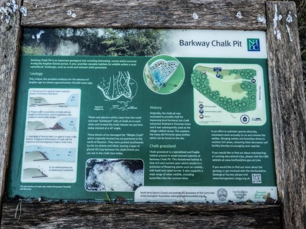
Figure 34: Information Board at the Chalk Pit
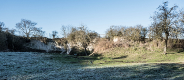
Figure 35: View into the Chalk Pit with Information Board
World War II anti-tank pillar, High Street, Barkway
Grid Reference: TL384355
Anti-tank defences were a key component of the anti-invasion defences constructed during the Second World War (World War Two), with anti-tank obstacles and road blocks springing up across the UK between 1940 and 1942 to halt and hinder the advance of enemy armoured vehicles. Many still survive though their function and landscape context remain under-recorded. Most were built of reinforced concrete in many shapes and sizes.
This pillar would be described as an anti-tank obstacle and there may well have been others that did not survive along what was a major route in the 1940's. It remains in good condition. It is not recorded in the HER.
Figure 36: Anti-tank Pillar, High Street
Flint House and Chestnut Cottages, Cambridge Road, Barkway
Grid Reference: TL385360
This fine group of Flint buildings are Noted in the Barkway Conservation Area Character Statement 2019 as a non-designated buildings considered to make a positive contribution to the character of the Conservation Area. Both are flint with brick quoins. Until recently Flint House was known as the Chestnuts, built around 1830 by a Doctor Balding. The two cottages slightly predate the house.
Figure 37: Flint House
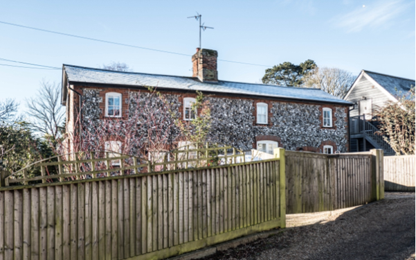
Figure 38: Chestnut Cottages
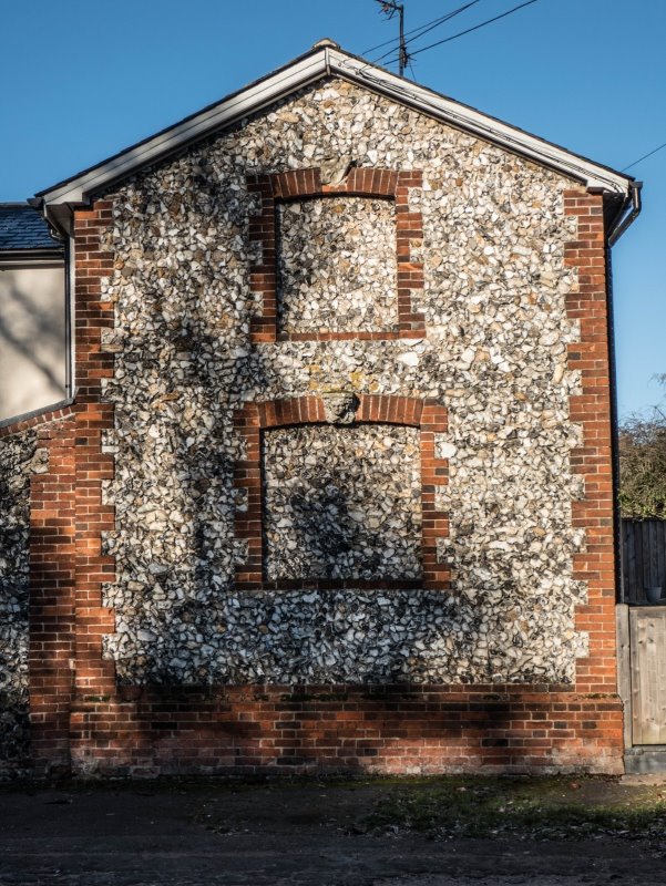
Figure 39: Chestnut Cottages (detail of end wall)
The Chaise and Pair, 1 High Street
Grid Reference: TL384359
It was listed as a Grade 3 building (a non-statutory designation that was abolished in 1970). It is of 18th century origin with later additions. It went through several iterations in naming, as other pubs did. The Chaise and Pair naming is very unusual. In the 1800s it had been known as the Post Chaise, and previous to that the Swan. Barkway Local History Group have a copy of a trade advert, held in the British Museum, from around 1800 which was issued to promote the owners hiring out post chaises. These were an alternative, private means of travel for the better off to avoid the uncomfortable regular stage coaches.
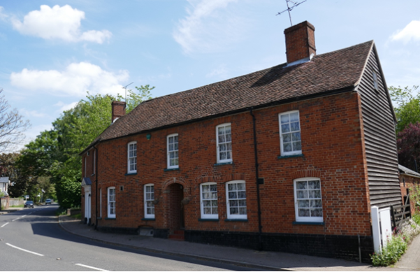
Figure 40: The Chaise and Pair (today)
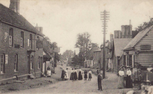
Figure 41: The Chaise and Pair (left) from on 1904 Postcard
The Coach House, High Street
Grid Reference: TL382366
The Coach House was originally part of the adjacent property, The Retreat, 75 High Street, a Grade II listed building. The Coach House is shown on OS Maps surveyed in the late 1870's and is most likely contemporary with 75 High Street, dating it c1800.
It is mentioned in the Historic Environment Record for The Retreat HHER 30612, as follows: "shown on the 1878 OS map with its garden filling the plot on the corner of Burrs Lane, with an outbuilding on the street corner (which survives, named The Coach House)".
Now a separate dwelling The Coach House has a new roof and entrance door, but retains it scale and presents a characterful corner to Burrs Lane. It is red brick with black weatherboarding on the three sides of the upper floor.
Figure 42: The Coach House, adj 75 High Street
Ashgrove, 140 High Street, Barkway
Grid Reference: TL383352
Ashgrove has late Georgian origins but was extended by the Stallibrass family to make a substantial farmhouse. The house is noted in the Barkway Conservation Area Character Statement 2019 as a non-designated building considered to make a positive contribution to the character of the Conservation Area. The barn at Ashgrove is also worthy of note with traditional black weatherboarding and original features inside.
Figure 43: Street frontage of Ashgrove, High Street
Figure 44: Front of Ashgrove
Figure 45: The Barn at Ashgrove
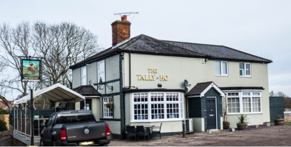
The Tally Ho Public House, London Road, Barkway
Grid Reference: TL383349
The Tally Ho lies on the southern edge of Barkway village. It was an unnamed beer house in 1872 and was given the name Tally Ho in c1893. The earliest mention of The Tally Ho is in Piggots Directory 1893.
During the coaching era, spanning a period of around 200 years, until the middle of the 19th century, many hostelries and inns catered for passing travellers. But, although population numbers have remained fairly constant, The Tally Ho is the last remaining pub. The pub's name is a reminder that the Puckeridge Hunt, amongst others, was prominent in the area and that a significant aspect of the parish's past and present has revolved around horses (with reference to Newsells Park Stud).
Stallibrass Almshouses, 118-122 High Street, Barkway
Grid Reference: TL384354
John Stallibrass was a rich local landowner in Barkway. His 3 great-granddaughters had the 3 almshouses built in his memory in 1909. They were provided for 3 local widows or spinsters of Barkway and still retain the requirement to provide shelter for single women. These decorative almshouses have had small additions built to provide basic facilities but remain virtually intact with their gabled entrances and decorative ridge tiles.
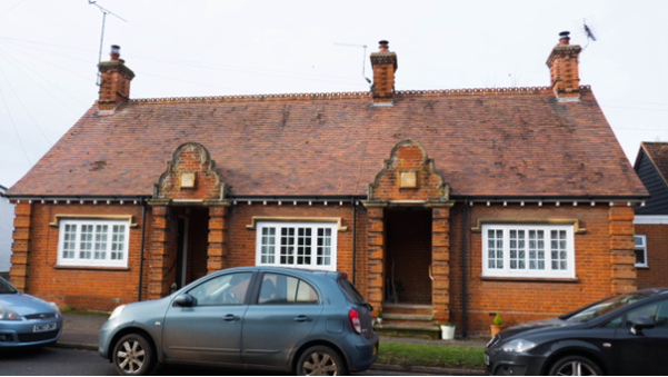
Figure 46L Stallibrass Almshouses
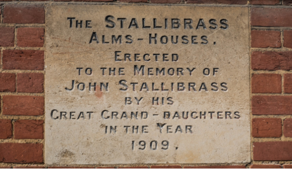
Figure 47: Plaque Dedication for the Almshouses
Newsells Historic Park & Garden
Grid Reference:
Newsells Park is a historic landscape of note. It is summarised in the Hertfordshire Historic Environment Record HHER1831, and categorised as LANDSCAPE PARK (Post Medieval - 1501 AD to 1900 AD). Described from a map dated 1766, the park included a perimeter belt, complete with sinuous walk, winding drives, specimen trees, informal clumps within the park and shrubberies threaded with sinuous paths lying each side of a broad vista on the north front of the house.
The park still includes an ornamental garden and paddock. The gardens were the work of Richard Woods, a contemporary of Capability Brown, who began working at Newsells in 1763. The lozenge-shaped kitchen garden is surrounded by red brick walls. The garden is recognised by Hertfordshire Gardens Trust as worthy of preservation.
The following paragraph is extracted from an article 'Newsells Estate in Barkway Part I' on Newsells by Barkway Local History Group:
"The 125-acre park at Newsells was reminiscent of a 'Ferme Ornee'. The mature trees surrounding the park are part of the original shelter belt that contained a circuit walk. An obelisk was erected close to the southern boundary providing a terminating vista. (Listed Grade 2, constructed of cement rendered brick with ashlar plinth and cornice to pedestal, and about 15 metres in height. Possibly rebuilt around 1900) The pleasure grounds included lawns, ha-ha, shrubberies, an evergreen walk, rose ground, sundial, grotto, a tent, a Little House and Ice House, as well as a walled kitchen garden, orchard, and several pools."
The photograph below was included in a leaflet published in 2015 illustrating a walk around Newsells and Cokenach historic parks.
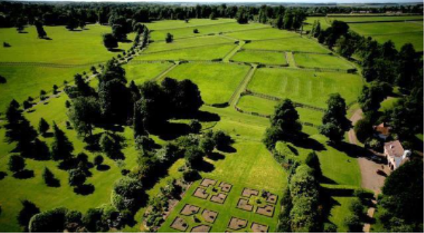
Figure 48: Newsells Park Garden
The map below shows the extent of the land included in the non-designated heritage asset classification in this Neighbourhood Plan.
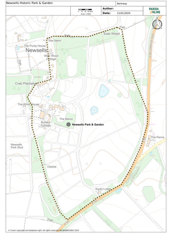
Figure 49: Detailed Map of Newsells Historic Park & Garden
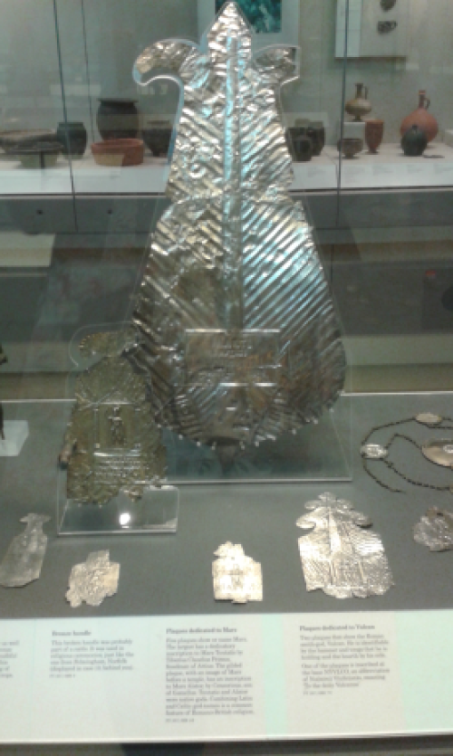
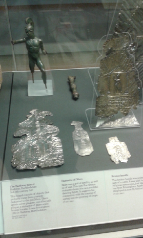
- Barkway Archaeological Finds
The following items have been found in Barkway parish and are illustrated in the picture below.
1.Exquisitely made silver bangle with gold inserts. It has no hallmark and was discovered about 9 inches below the ground. Possibly Roman.
2.Metal dragon with evidence of enamelling. Found near and at the same depth below ground as item 1. Possibly Roman or Welsh bearing in mind that the Welsh adopted the dragon symbol from the Romans.
3.One silver coin plus three silver half coins – early English medieval.
4.Five very corroded Roman coins – sometimes referred to as "grots".
5.1877 Victorian penny piece.
6.1860 Victorian florin piece.
7.1957 Elizabeth 2nd half-crown.
8.George 1st silver coin.
9.George 2nd 1733 coin.
10.George 3rd bronze coin.
11.Silver denarius serratur of the Roman republic. On the obverse is a three-horse chariot or triga. Coins of the Roman republic are often found in England and Wales as they were still in circulation until the reign of Emperor Hadrian in the 2nd century AD.
12.Elizabeth 1st silver shilling.
13.Old brass coat button with an image of a greyhound (possibly connected with Barkway House).
Pictures of Barkway Hoard:
– Community Events Summary
|
Event |
Brief Description |
Date |
Venue |
No. attendees/ respondents |
|
Launch meeting |
Principles of a NP explained and option of joining Barkway & Nuthampstead put forward |
28 Nov 2013 |
Barkway village hall |
|
|
Survey |
Questionnaire to all households in Barkway & Nuthampstead covering housing, traffic, wellbeing etc. |
May-July 2014 |
All households in Barkway & Nuthampstead |
|
|
Survey results |
Public meeting to present the results of the survey |
23 Oct 2014 |
Barkway village hall |
|
|
Focus group creation |
Comprising young families to obtain their feedback |
|||
|
Public meeting |
To explain the re-start of the NP and allow Q&A |
07 Feb 2019 |
Community room at Barkway pavilion |
60 |
|
Housing needs survey |
Conducted by CDA Herts |
Mar-Apr 2019 |
All households in Barkway & Nuthampstead |
|
|
Public meeting |
Draft vision & objectives presentation |
29 May 2019 |
Community room at Barkway pavilion |
27 feedback forms |
|
Public meeting |
To provide information and elicit feedback on local green spaces, important views and draft policies |
21 Sep 2019 |
Community room at Barkway pavilion |
50 (43 feedback forms) |
|
Barkway monthly parish council public meetings |
At each of the monthly meetings, a councillor who is a NP representative provided a summary of progress |
monthly |
Community room at Barkway pavilion |
Variable |
|
Nuthampstead parish meetings |
A member of the NP team provided a summary of progress to officers of the parish meeting and to the AGM. |
As required |
Woodman Inn (for the AGM) |
Variable |
- Glossary of Terms
Affordable Housing
Housing for sale or rent made available, based on the evidence of need, to people whose needs are not met by the market, including social housing.
Bird listing – red and amber
The rarity of various bird species is indicated by a colour scheme used by the Royal Society for the Protection of Birds (RSPB). Red-listed birds are those considered to be under the greatest threat while those of moderate concern are amber.
Local Green Space
A national designation of land made through local and neighbourhood plans which allows communities to identify and protect green areas of particular importance to them.
Groundwater Source Protection Zone
The zone within which there may be risk of contamination of public drinking water supply.
SuDS/Sustainable Urban Drainage System
An alternative system to conventional pipes designed to manage surface water which mimics natural systems by, for example, managing rainfall close to where it falls.
Sustainable Development
Development that meets the needs of the present without compromising the ability of future generations to meet their own needs.
S106 Contributions (and other funding mechanisms)
Section 106 (s106) of the Town and Country Planning Act 1990 are legally-binding agreements or planning obligations made between local planning authorities and developers. These are linked to the granting of planning permissions with the aim of ensuring that matters that are necessary to make a development acceptable in planning terms are addressed and/or delivered. Other funding mechanisms may include a Community Infrastructure Levy (CIL) which North Herts Council may introduce in the future.
- Abbreviations
CIL Community Infrastructure Levy
CDA Community Development Action
CMS Countryside Management Service
HCC Hertfordshire County Council
HERC Hertfordshire Environmental Records Centre
HGV Heavy Goods Vehicle
HPG Historic Park or Garden
NERC Natural Environment Research Council
NHC North Herts Council
NHLP North Hertfordshire Local Plan
NP Neighbourhood Plan
NPPF National Planning Policy Framework 2023
(P)ROW (Public) Right of Way
SuDS Sustainable Urban Drainage System
RSPB Royal Society for the Protection of Birds
USAAF USA Air Force
– References and Supporting Documents
Assets of Community Value (England) Regulations
Barkway and Nuthampstead Basic Conditions Statement
Barkway and Nuthampstead Consultation Statement
Barkway Conservation Area Character Statement
Barkway Parish Plan June 2010
Braughing Parish Neighbourhood Plan 2017-2033
Building for Life 12 (third edition) 2015
Compulsory Purchase Act (2004)
Domesday Book
Heritage Definitions: Designated Heritage Asset and Non-designated Heritage Asset
Herts and Middlesex Wildlife Trust Maps and Data (provided by Herts Environmental Records Office)
Historic England Local Heritage Listing - Historic England Advice Note 7 (Second Edition)
The National Heritage List for England - Historic England
Housing Needs Report Barkway and Nuthampstead CDA Herts 2019
National Planning Policy Framework 2023
North Herts Council Greenspace Action Plan 2022-2027
North Hertfordshire Local Plan 2011-2031
Nomis Official Labour Market Statistics
Town and Country Planning Act (1990)
– Barkway and Nuthampstead Design Codes and Guidance
The Barkway and Nuthampstead Design Codes and Guidance, February 2024, was produced by AECOM for the Barkway & Nuthampstead Neighbourhood Plan. It forms an integral part of the Neighbourhood Plan but due to its size is saved as a separate document.
A copy of the Barkway and Nuthampstead Design Codes and Guidance can be found on the Neighbourhood Plan page of Barkway Parish Council website.
– The Neighbourhood Plan Team
A group of parish residents volunteered to form a Steering Group to develop this Plan, under the auspices of the Parish Council. They researched a wide range of topics; they ran consultation events, public meetings and workshops; they liaised with local authorities and other local and national bodies. The result was a vast amount of information, which has been compiled and structured to write this Plan.
The members of the Neighbourhood Plan Steering Group are:
Bill Dennis (chair)
Catharine Toms
Elena Sapsford
Jackie Connolly
Julia Magill
Louise Fletcher
Mike Chapman
Peter Baker
Sue Sanders
The Steering Group has been professionally advised and supported by:
Govresources Ltd.
Additional members of the Steering Group in its early days, and others who have helped with the plan are:
Bob Davidson
Giuseppe Frapporti
Graham Swann
Kristian Melson
Phil Birchell
Sonia Falaschi-Ray
Photographs have been provided by Bill Dennis, Catharine Toms, Elena Sapsford,
Julia Magill, Julia Church and Sue Sanders.
A special thanks to Louise Fletcher for proof reading the document.
All mapping is © Crown copyright 2019 OS licence 100055315.
– Action Plan
|
Id |
Aim |
Action |
Resp. |
Timescale |
|
1.1 |
Develop a community hub |
Contact local health providers to arrange health facilities at the hub |
PC |
6mth-2yr |
|
1.2 |
Develop a community hub |
Arrange library collection/return facilities at the hub |
PC |
6mth-1yr |
|
1.3 |
Develop a community hub |
Liaise with local charities to provide services |
PC |
6mth-2yr |
|
1.4 |
Develop a community hub |
Create intergenerational garden |
PC |
1-2yr |
|
1.5 |
Develop a community hub |
Establish Skype facilities to enable remote access to health advice |
PC |
1-2yr |
|
2.1 |
Obtain dementia friendly status for the villages |
Arrange dementia training classes |
PC |
6mth-2yr |
|
2.2 |
Obtain dementia friendly status for the villages |
Contact local societies to arrange training for members of each |
PC |
1-2yr |
|
2.3 |
Obtain dementia friendly status for the villages |
Arrange specific events for those with dementia and their carers |
PC |
1-2yr |
|
2.4 |
Obtain dementia friendly status for the villages |
Investigate facilities improvements to help those with dementia |
PC |
1-2yr |
|
3.1 |
River maintenance |
Investigate ways of improving & maintaining the River Quin, possibly getting involved with Friends of the Rivers Rib and Quin |
PC |
1-3yr |
|
4.1 |
Introduce traffic calming measures |
Set up new high-visibility traffic speed warnings at the entrances to Barkway |
PC |
1-2yr |
|
4.2 |
Introduce traffic calming measures |
Set up new high-visibility traffic speed warnings at the entrances to Nuthampstead |
PC |
1-2yr |
|
5.1 |
Improve parking |
Identify off-street parking for congested areas of the High Street |
PC |
2-3yr |
|
5.2 |
Improve parking |
Incorporate off-street parking for at least two cars/house in all new builds |
PC |
1-15yr |
|
6.1 |
Review & enhance public transport provision |
Investigate introduction of earlier/later buses and improvements to weekend bus service |
PC |
1-3yr |
|
6.2 |
Review & enhance public transport provision |
Investigate the use of shared transport suitable for the elderly such as a village minibus |
PC |
1-3yr |
|
7.1 |
Improve communications network |
Introduce superfast broadband to most of the parish |
PC |
1-2yr |
|
8.1 |
Improve footpaths & cycle-tracks |
Investigate footpath routes to the local schools as a priority to see how they can be made safer |
PC |
6mth-2yr |
|
8.2 |
Improve footpaths & cycle-tracks |
Investigate improvements to other footpaths including ongoing maintenance |
PC |
6mth-15yr |
|
9.1 |
Ensure that new builds abide by housing policies |
Review all new builds – both at the planning stage and during construction to ensure adherence to policies |
PC |
0-15yr |