Barkway and Nuthampstead Neighbourhood Plan 2018 - 2031
(2) 4 NEIGHBOURHOOD PLAN POLICIES
4.1 HOUSING
Housing Development Strategy
4.1.1 The Neighbourhood Plan does not contain housing site allocations and is not required to in the Local Plan. The adopted NHLP includes two site allocations for a total of 160 homes in Barkway. This will represent an increase of over 40% in the number of homes in the village since the 2021 census. The number of housing completions and planning permission granted in Barkway since 2011 accounts for an additional 57 homes. The total allocated, completed and permitted homes since 2011 is therefore 217, more than doubling the size of the village. For the purposes of NPPF, paragraph 14 b) the housing needs of Barkway village have therefore been met for the life of the Neighbourhood Plan.
4.1.2 This chapter of the Neighbourhood Plan considers housing needs, design, housing site allocation BK3, and infill, extensions and backland development.
Housing Needs
4.1.3 A Housing Needs Survey was conducted for Barkway and Nuthampstead in March-April 2019. The Housing Needs Survey and the District Strategic Housing Market Assessment will be used to identify affordable housing requirements. Some of the key results in the Housing Needs Survey are detailed below.
4.1.4 A need for a total of 18 extra affordable or sheltered homes was identified in Barkway and Nuthampstead, mainly two-bedroom; this is in addition to the 58 affordable homes currently in the area.
4.1.5 The preferred recipient and type of tenure is illustrated in the table below and includes sheltered/adapted and bungalow accommodation.
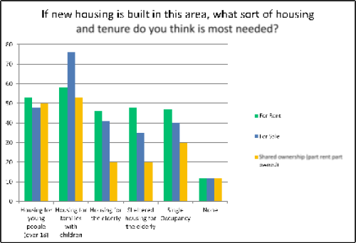
Figure 6: Tenure type by potential recipient
4.1.6 The prevalent number of bedrooms desired was for one- or two-bedroom homes, as shown in the table below.
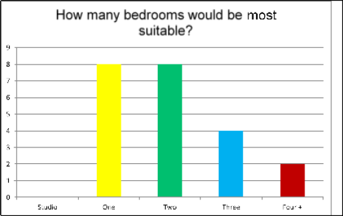
Figure 7: Most popular house size
4.1.7 Some interest was also shown for community-led or self-build schemes to help address the need for affordable housing.
4.1.8 Concerns were raised in the survey about the lack of infrastructure and the suitability of local roads to support significant new development.
(1) Policy BN H1 Affordable Housing
Affordable homes should include a mix of ownerships, provision for sheltered/adapted and bungalow units, and a range of sizes - but supporting the locally identified housing need in the Housing Needs Survey and Strategic Housing Market Assessment. Community-led housing and self-build schemes could be an option to provide for the need for affordable homes.
Design
4.1.9 Housing design needs to be sympathetic to the housing in the immediate area. Chapel Close is an example of a recent housing development which is more traditional.
4.1.10 Both Barkway and Nuthampstead include a juxtaposition of different styles which gives the villages a unique appearance and enhances the Barkway Conservation Area. It is important to maintain this variety in any expansion to the village and avoid estates of similar buildings. Some examples below in Barkway High Street illustrate these different designs.
Figure 8: Housing Character in Barkway High Street
4.1.11 Environmental sustainability is important in the design of new homes, in particular to reduce reliance on fossil fuels, in the context that NHC has declared a climate emergency. This approach would also contribute to health and well-being by ensuring residents are warm enough and potentially taking people out of fuel poverty (around 8% of the Ermine Ward community are in fuel poverty). Public health evidence is that this could also play a part in reducing hospital admissions for hypothermia and heart attacks, especially in winter months.
4.1.12 The Centre for Sustainable Energy (CSE) has long maintained that neighbourhood plans should include policies on mitigation and adaption to climate change. The UK government needs help to meet its commitments under the Climate Change Act, to stop global warming. CSE advocate neighbourhood plans filling the vacuum while local plans 'catch up'. Neighbourhood plans can help boost the ambitions of developers of all sizes from new estates to a single self-build. In the absence of any specific policy in NHLP for the incorporation of renewable energy in new developments, Policy BN H2 requires a minimal level of renewable energy generation, which should not impact on the viability of a development scheme, in the hope that developers will exceed this minimum.
4.1.13 Developers should take full account of Building for a Healthy Life (a new iteration of Building for Life 12), or subsequent versions thereof, and use this guidance, to help enhance the positive benefits of new development for current and future generations. This provides government guidance on construction management processes, design, building safety and infrastructure, Modern Methods of Construction, and self and custom build, under the title of Building Healthy Places.
4.1.14 The structure of the rest of the Design Section of the Neighbourhood Plan is set out as follows:
Policy BN H2 Design and Layout
Policy BN H3 Sustainable Construction
Policy BN H4 Design Code
Policy BN H5 Framework for BK3
Policy BN H6 Infill Development
Policy BN H7 Extensions, Outbuildings and Garages
Policy BN H8 Backland Development
(1) Policy BN H2 Design and Layout
A proposal for residential development, including a redevelopment, will be permitted provided that all of the following design criteria are met:
- It is in keeping with existing local architectural styles (other than unsympathetic 20th century infill) so as to contribute to local distinctiveness;
- It respects and enhances local character with a sufficient variety of styles and heights. Preferred styles in the conservation area include timber framing, pargetted walls, thatch, flint and red brick (for more detail see Barkway and Nuthampstead Design Codes and Guidance 2024). Building heights will be no more than three-and-a-half storeys. Good modern design will be acceptable in some cases;
- Development is in proportion to surrounding buildings, especially in terms of principal elevations, preserving traditional ratios of doors and windows to the total frontage area;
- Brickwork, including replacement brickwork, blends in with surrounding walling in both colour and texture;
- It does not lead to the loss of amenity for neighbouring users through the loss of privacy, loss of light or visual intrusion;
- The amenities of nearby residents will be protected during the construction phase;
- It respects the natural contours of a site while, where possible, protecting and sensitively incorporating natural features such as trees, hedges and ponds within the site;
- Solid boundaries such as fences should be avoided in front gardens to maintain the open feel of the village;
- It creates safe, accessible and well-connected environments that meet the needs of users;
- All public areas resulting from new development proposals must be visible and overlooked in accordance with good practice in order to create an environment that feels safe.
(2) Policy BN H3 Sustainable Construction
A proposal for residential development, including a redevelopment, will be permitted provided all of the following criteria for sustainable construction are met:
- Housing should be designed with flexible, adaptable spaces, including for people with mobility problems;
- Social housing should include homes fitted with smart technology to support people with disabilities, including dementia, in support of the aspiration of Barkway and Nuthampstead to be dementia friendly villages;
- The incorporation of best practice fire suppressant technologies to prevent damage and injury from fire will be encouraged;
- The incorporation of micro-energy schemes (including ground source heat pumps, heat exchange systems, solar panels and emerging green technology), in new homes. New homes to be designed and constructed to achieve a minimum level of energy performance set at Level 6 of the Code for Sustainable Homes, where this is viable;
- Secure cycle storage will be included for all homes to encourage sustainable travel;
- The inclusion of facilities to enable water conservation, including consideration of grey water harvesting;
- Proposals for residential development will provide adequate storage for bins and recycling;
- All new hardstanding will be constructed of locally appropriate permeable materials such as stone or brick paving, hoggin and gravel;
- Development will include Sustainable Drainage Systems (SuDs) incorporating storage for natural run-off and run-off from new development. Multi-use above ground SuDs will be encouraged. Funding management and maintenance plans should be secured at the earliest stage;
- Construction work must be carried out in accordance with relevant standards and best practice to ensure protection of the groundwater Source Protection Zone.
4.1.15 The Barkway & Nuthampstead Design Codes and Guidance 2024 establish Neighbourhood Plan area-wide design guidelines and codes to ensure that any development follows good design practice and contributes to sustainable development. Particular focus is provided for the partially vacant Bell Farm Industrial Park in Nuthampstead which has outline planning consent (23/00549/OP) for 9 dwellings, and the NHLP allocated site BK3 in Barkway. The Design Codes steer design of new development to ensure that the homes delivered on these sites are in keeping with the distinct character of the two villages.
4.1.16 Parts 2 and 3 of the Design Codes provide technical descriptions, maps and photos to capture the character of the villages, and the surrounding rural area. These can be referred to as a local character study to ensure that where 'character' is mentioned in this Neighbourhood Plan, the Design Codes describe that character, as a reference source.
4.1.17 Part 4 comprises the design guidance and codes themselves which are a set of principles under four themes: settlement pattern; movement network; built form; and landscape and infrastructure. Part 5 applies the codes to the Nuthampstead employment site and BK3. For BK3, the codes should be read in conjunction with Policy BN H5 Framework for BK3. Policy H5 picks up on some very specific criteria that are important to the community, in order to get the best and most sustainable development on this large site on the edge of Barkway village.
(2) Policy BN H4 Design Codes
The design of all development proposals shall be assessed against the Barkway and Nuthampstead Design Codes and Guidance 2024. The Code forms a statutory part of the Neighbourhood Plan and should be used to prepare applications for planning permission in the Parish (see Appendix M).
Housing Site BK3
4.1.18 The NHLP 2011-2031 identified three sites in Barkway for development, known as BK1, BK2 and BK3. BK1 and BK2 have been built. BK3 is shown on the Policies Map. The village boundary was amended in NHLP to include these three development sites.
4.1.19 BK3 is identified in the NHLP for the development of up to 140 dwellings. Outline planning consent (18/01502/OP) was conditionally granted on 25 July 2023. Local residents continue to be strongly opposed to this development, which is excessive for the size of the village, in which there is a lack of key infrastructure such as good public transport and shops. Barkway Parish Council have objected to the allocation of so many new homes. The Parish Council will now concentrate its efforts on influencing the detail of the development to achieve a characterful and environmentally sensitive design, which reduces the harmful impacts on the village.
4.1.20 Site BK3 is located on the Barkway Plateau (Area 230 of the North Herts Landscape Character Assessment) and on the Chiltern Ridge, is valuable Grade II agricultural land, is close to the Newsells Stud which is surrounded by a non-designated garden, and adjacent to Cokenach Grade II Historic Park and Garden. The site and its surroundings are so sensitive that layout, height and massing of development must be carefully planned. Particular attention should be paid to the design and appearance of homes at the edges of the site where they border surrounding green fields and Cokenach Park. The retention and enhancement of the trees and hedges around the boundaries of the site is also essential.
4.1.21 The popular bridleway, which is in daily use, runs north-south through the site and must remain open and accessible at all times during the development. A sufficient buffer is needed either side of the bridleway to ensure that the route is kept free of intimidation or danger from construction machinery during the build period. In its current state, fencing the bridleway to define the space would not be safe for walkers, cyclists, horses or their riders, due to parts of the route being too narrow.
4.1.22 The Parish Council have produced a survey report for Bridleway 17 from its most southerly point on Cambridge Road through site BK3 to the point where it enters Newsells Estate. The report notes the British Horse Society recommended a turning circle for a horse of 4 metres. Where the useable width of a bridleway is less than 4 metres, it would be impossible to turn a horse in such a confined space should walkers and horse riders be using the bridleway at the same time.
4.1.23 From Cambridge Road, past Barkway Social Club, then turning north and running alongside the field owned by HCC and identified as a reserve site for a school, the bridleway meets the 4 metre requirement. The width reduces significantly from that point until Bridleway 17 meets Bridleway 18, a distance of almost 200 metres. At its worst point, the useable width is just 2.15 metres and at no point does the bridleway's actual width reach 4 metres.
4.1.24 The Parish Council does not support the proposed BK3 through-road crossing Bridleway 17 and will continue to negotiate to ensure access between the two parts of the development is for pedestrians/cyclists only. The remedial work necessary to make the Bridleway 17 safe, (i.e. ensuring the useable width of the Right of Way is 4 metres, with appropriate new planting) should be completed before construction work on the housing site commences. The additional planting would be beneficial to wildlife and would ensure that the effectiveness of the wildlife corridor endures through the construction stage and occupation of the new homes.
4.1.25 A major concern to residents and the Parish Council, is the inability of the local sewage treatment works to cope with the current levels of sewage and the fears that the pollution of the River Quin will worsen once the new homes on BK3 are built and occupied. Sewage treatment upgrades are likely to be required to accommodate the proposed development. Any upgrade works identified will be necessary to avoid sewage flooding and/or potential pollution incidents.
4.1.26 The planning consent contains a condition (Condition 9) requiring that "No development shall be commenced until confirmation has been provided that either: all sewage works upgrades required to accommodate the additional flows from the development have been completed; or a development and infrastructure phasing plan has been agreed with the Local Authority in consultation with Thames Water to allow development to be occupied. Where a development and infrastructure phasing plan is agreed no occupation shall take place other than in accordance with the agreed development and infrastructure phasing plan." The Parish Council are committed to ensuring that there is no deviation from this condition, to ensure the River Quin is safeguarded.
4.1.27 Elsewhere in the Neighbourhood Plan, the lack of public transport available in the village and the need to review and improve public transport provision is well documented. In order to ensure that the development of BK3 is sustainable, this lack of provision, with no alternative to use of the private car, must be addressed before new homes are occupied. It will not be sufficient to rely on increasing active travel modes, for example, for a developer to provide cycle storage for each home when the roads around Barkway are dangerous for cyclists. The lack of public transport must be addressed.
4.1.28 In order to maximise new habitat and ensure no net loss of biodiversity across the site and comply with policy BN NE3 in this plan, new public open space provided should include new wildlife habitats, trees and hedges.
4.1.29 To the south west of site BK3 is a Hertfordshire County Council reserve school site for future use for primary education, should it be required. The incorporation of this reserve school site into the site allocation was made when NHLP was adopted. This part of the site should remain undeveloped until it is needed for a school (if ever) and should remain, in the interim, fallow or in agricultural use but be clearly delineated from the housing site by the planting and maintenance of a native hedgerow.
(3) Policy BN H5 Framework for BK3
Land identified in NHLP 2011-2031 as BK3 (shown on the Policies Map) is planned for the provision of 140 dwellings. Any scheme will have regard to the principles set in Barkway and Nuthampstead Design Codes and Guidance 2024, and take into account the policies in this Neighbourhood Plan relating to design and layout in addition to all the following criteria:
- The design, height and massing of development must respect views across the site from Cambridge Road and maintain views across surrounding landscapes;
- Financial contributions will be secured to improve walking and bus access between Barkway and Nuthampstead and surrounding villages, notably Barley and the town of Royston where essential services are located, for community use and not just for travel between Barley and Barkway schools. The details will be agreed in consultation with Barkway Parish Council;
- Land at the south-west of the site, secured as a reserve site for primary education, should remain fallow or in agricultural use until such time as it is required for a school, but be clearly delineated from the housing site by the planting and maintenance of a native hedgerow;
- To reduce impact on the countryside, provision of 'green roofs' on dwellings on the eastern part of the site will be expected as it demonstrates sensitivity to the transition between the new village edge and the surrounding open fields;
- Any public open space must feature natural pockets of wildlife habitat, trees, hedges and benches;
- Remedial work along Bridleway 17, to widen the route where the useable width is less than 4 metres, must be carried out to ensure the safety of walkers, cyclists, horses and their riders. Appropriate planting along Bridleway 17 will be required to ensure the endurance of the wildlife corridor during construction and occupation of the new homes;
- No development shall be commenced until either the sewage works upgrade required to accommodate the additional flows from the development have been completed, or a development and infrastructure phasing plan has been agreed with the Local Authority in consultation with Thames Water to allow development to be occupied.

Figure 9: Indicative Plan - Reserve School Site (BK3)
Infill and Extensions
4.1.30 Infill development within the built-up area of the villages and extensions to existing buildings should be sensitively designed to reflect the character of the existing and adjacent buildings, and their surroundings. It is also important to preserve the amenities of existing residents.
(2) Policy BN H6 Infill Development
Small-scale infill development will be supported provided that it is located within the built-up areas of the village, as shown on the Policies Map, is preferably on brownfield sites rather than greenfield sites and meets all the following criteria:
- It retains views, open spaces and large gardens that contribute to the enjoyment of residents of the village and are important to the character and appearance of the Barkway conservation area;
- It does not increase traffic and parking problems on Barkway High Street;
- It is designed to reflect the local vernacular style, village layout, and character in accordance with Policy BNH1.
(1) Policy BN H7 Extensions, Outbuildings and Garages
Proposals for extensions, outbuildings and garages, where planning permission is required, will be permitted provided that they meet the requirements of NHLP Policy D2 and all the following criteria:
- The development fits unobtrusively with the existing building and the character of the street scene;
- Materials used are complementary to those of the existing house;
- The privacy, daylight, sunlight and outlook of adjoining residents are respected;
- The proposal does not lead to the loss of green spaces.
4.1.31 Barkway is particularly sensitive to the impact backland development could have on the structure of the village. As a linear village where development has been on the historic ribbon development principle, this character should be continued. This view was supported by North Herts Council at an appeal (reference APP/X1925/W/18/3195832 on 10th September 2018) where it expressed concerns 'that the form of development would not reflect a ribbon or loose knit pattern of development that characterises Barkway'.
(1) Policy BN H8 Backland Development
Proposals for small-scale backland development in Barkway will be supported where they do not harm the linear character of the village.
4.2 NATURAL ENVIRONMENT
Green Spaces
4.2.1 The NPPF paragraph 105 enables local communities to identify green areas of particular importance to them for special protection. By designating land as "Local Green Space" in the Plan it is offered extra protection. Policies for managing development within a Local Green Space should be consistent with those for Green Belt. The benefit of such a designation is that the character of the site can be specified and therefore development that would harm that character will be refused.
4.2.2 A site that is so defined must meet the criteria specified in the NPPF paragraph 106, by being:
- in reasonably close proximity to the community it serves;
- demonstrably special to a local community and holding a particular local significance, for example because of its beauty, historic significance, recreational value (including as a playing field), tranquility or richness of its wildlife; and
- local in character and not an extensive tract of land.
4.2.3 To assess each site a detailed set of criteria was used.
- Beauty - Does the site stand out as being particularly beautiful or tranquil?
- Intrinsic local character - Is the site particularly special to the local community or used for community events?
- Recreational value - Is the site used for local recreational purposes e.g. footpath?
- Historical significance - Does the site have special historical interest?
- Natural wildlife - Is there evidence of rare species on the site which need protection?
4.2.4 There are also a number of more objective measures which had to be passed for a site to qualify:
- be close to the community it serves
- be relatively small (< 10 hectares)
- not have planning permission
- have a known landowner
- not be private garden
- not have a national designation or be just a statutory right of way
- not be common land or a designated village green
- not be arable land
4.2.5 Nine sites meet the criteria and received overwhelming public support at the September 2019 consultation day. They are shown on the Policies Map in Chapter 3.1 and are shown in more detail in Appendix B- Local Green Space Evidence.
(2) Policy BN NE1 Local Green Space
The areas listed below, described in the text above and identified on the Policies Map, are designated as Local Green Spaces. New development will only be allowed within designated Local Green Spaces where very special circumstances can be demonstrated, in accordance with the National Planning Policy Framework.
L1 – Forest school site
L2 – Field to the west of Rushing Wells
L3 – Manyon's field, including Withy Grove
L4 – Carriage Wash and adjoining grass verge
L5 – Barkway village pond
L6 – Land encompassing Three Roods Lane
L7 – Wheatsheaf Meadow Garden
L8 – Windmill Close
L9 – Grove at Caylers Farm, Nuthampstead
River conservation
4.2.6 The River Quin, a protected chalk river, originates in Barkway parish from where it flows south until it joins the River Rib to the south of Braughing. As few as 200 chalk rivers exist worldwide, 35 of which are in the UK. In 2012, a charter drawn up by conservationists called for them to be designated 'Special Areas of Conservation' and an EU directive recognises their importance. Chalk rivers are listed as a key habitat within 'Biodiversity: The UK Steering Group Report' and also support species such as the severely threatened white-clawed crayfish, which are listed on Annex II of the EC Habitats Directive. Characteristic plant species of chalk rivers include the stream water-crowfoot and water starwort.
4.2.7 The Herts and Middlesex Wildlife Trust has recommended the identification of all chalk rivers because of their rarity. In addition, both the River Lea Catchment Partnership and the Friends of the Rib and Quin action group will take an active interest in the protection of this river (see Appendix O– Action Plan for proposed actions to protect the river). More specifically, the Environment Agency has recommended the protection of the River Quin and provided guidance on a 10 metre boundary around the river; this was included in feedback to the Braughing Parish Neighbourhood Plan which features the same river. We have extended this protection to the tributaries of the River Quin, of which there are two significant tributaries around Nuthampstead, as any adverse impact on a tributary is likely to have a direct effect, downstream, on the River Quin.
4.2.8 Despite NHLP requiring only an 8 metre buffer for an average river, the River Quin is both a rare chalk stream and at considerable risk of damage from other sources, including pollution. In this circumstance, the Neighbourhood Plan is requiring a level of protection slightly higher than that in the NHLP. This is a detail which remains in general conformity with the strategic policies contained in the Local Plan, to ensure development in the Neighbourhood Plan area is sustainable.
Policy BN NE2 River Quin Protection
The River Quin, which originates in Barkway, is a protected chalk river and no development will be permitted within at least 10 metres from the top of the bank of the river, or its tributaries, in order to protect and enhance the conservation value of the watercourse and ensure access for flood defence maintenance.
Wildlife
4.2.9 The village of Barkway is located on an eastern spur of the Chilterns. To the north from the Reed Joint, a chalky ridge, the chalkland drops away to Royston. Nearby, an ancient chalk pit is protected by the Wildlife Trust. However, the village itself lies on boulder clay deposits where several springs issue from the conjunction of chalk and clay and where there are several large ponds. Consequently, the local water table is high and there is a history of flooding in the village.
4.2.10 The land is predominantly arable with some grazing, and rolls gently south towards the Quin valley, becoming less wooded than in the north. Many lanes and rights of way allow access to well-wooded areas. Buzzards and red kites are frequently seen soaring over the woods and hills and herds of fallow deer can be found at dusk in hidden valleys and woodland.
4.2.11 The uncultivated fields within Barkway enhance the informal character of the village. The Plan aims to maintain or improve biodiversity including sites, species, hedgerows, trees and wildlife habitats.
4.2.12 Nuthampstead is a quiet countryside village with wide open spaces and a rural environment, with mixed farming being the dominant activity. The area includes woodland – some ancient, some more recent – all interspaced with public footpaths.
4.2.13 Cokenach Registered Park and Garden is an English Heritage listed country estate built in the sixteenth century. The estate business runs a number of ventures including farming, a business centre and sporting events, including deer stalking and shooting. Set in 111 acres of beautiful, rural north Hertfordshire, it is both an historic site and a natural haven for wildlife, with numerous footpaths and bridleways criss-crossing the estate.
4.2.14 The owners of Cokenach are committed to maintaining the estate environment and conservation of farmland, parkland and woodlands and are currently operating a number of stewardship schemes across the estate to manage protected areas and encourage natural wildlife and species diversification.
4.2.15 There are 10 ancient woodlands in the parishes of Barkway and Nuthampstead, which is a valuable asset over a comparatively small area. In addition to those listed below as Local Wildlife Sites are Pondbottom Wood, Wigney Wood, Cross Leys, and Oaks Bushes. The ancient woodland, Rokey Wood, is a large tract of ancient woodland, lying to the west of Barkway between two footpaths, consisting mainly of ash, maple, oak and hazel trees. Bluebells grow there, and rare lichen has been recorded; there is also evidence of badgers.
4.2.16 Barkway Chalk Pit has been identified as an area rich in wildlife which needs to be protected and managed (see North Herts Council Greenspace Action Plan 2018-2023 which includes a new appendix for 2023-2028 for this site). It contains many chalk-loving plants and mosses including the rare chalk rock-bristle. Many birds make their home there, some of which are endangered such as the red-listed corn bunting and yellowhammer and the amber-listed swallow, whitethroat and bullfinch. Fauna includes brown hares, red foxes, fallow deer and the latticed heath moth.
4.2.17 Local Wildlife Sites in Barkway and Nuthampstead are shown on the map in Appendix C (Local Sites of Environmental Interest) and listed below:
- Whiteley Hill Road Verge (08/007)
- Bush Wood (08/016)
- Rokey Wood (small part) (08/017) (ancient woodland)
- Barkway Chalk Pit (08/020) Regionally Important Geological / Geomorphological Site (RIGS)
- Earl's Wood (08/021) (ancient woodland)
- Walk Wood (08/022)
- Bogmoor Road Verge (08/024) (wildlife corridor)
- Barkway Meadow (08/039)
- Cokenach Area (08/047/01)
- Barkway House Area (08/050)
- Newsells Park Stud Area (08/054)
- Nuthampstead Field Boundary Ditch (09/001) (wildlife corridor)
- Sheepwash and Messop's Groves (09/002) (ancient woodland)
- Wynnel's Grove (part) (09/012)
- Ash Grove (09/013) (ancient woodland)
- Morrice Green Pit and Meadow (09/014)
- New England Moor (09/015)
- New England Wood/Doctor's Grove (part) (09/016)
- Biggin Moor (part) (15/002)
- Scales Park and East Wood (large part) (16/002) (ancient woodland)
(3) Policy BN NE3 Conserve and Enhance Biodiversity
Development will be supported where it:
- Has a positive impact on designated local wildlife habitats or corridors listed above;
- Aims to protect and enhance designated local wildlife habitats and corridors wherever possible;
- Seeks to retain and restore existing hedgerows and protect mature trees (in particular trees framing the war memorial in Nuthampstead and the avenue of trees in Bell Lane leading towards The Woodman) and encourages the planting of new hedgerows and woods, on condition that they do not impact on important views;
- Results in no net loss of biodiversity;
- Keeps outside lighting to a minimum to avoid disturbance to nocturnal species and preserves the view of the night sky.
The wildlife site at Barkway Chalk Pit will be protected and managed in accordance with North Herts Council Greenspace Action Plan 2018-2023.
Schemes that would decrease the biodiversity value of sites which contain habitats listed in Section 41 of the NERC Act should be avoided unless the benefits of development clearly outweigh any impacts, and a mitigation hierarchy is applied. See Appendix D.
4.2.18 Barkway and Nuthampstead are fortunate to have many beautiful views. Not all of them can be listed but some are chosen as having a particularly high priority so they can be afforded greater protection. These include views towards key focal points, such as Earl's Wood, Rokey Wood, the Chiltern Escarpment, the ancient Chalk Pit, Barkway Mast and Newsells Stud.
4.2.19 The important views are described and photographed along with an assessment of their value in Appendix E. Detailed maps of the range and extent of the views are also found in this appendix. They have been designated following approval at a public consultation meeting in September 2019, with some updates after the Regulation 14 consultation. The judgement criteria for important views were presented at the Consultation event and are:
- Views should be readily accessible to the public (e.g. on a Public Right of Way (PROW);
- Views that include a feature of artistic merit, have historic interest, possess architectural merit, or are a natural feature such as a river;
- Views on entry to the key settlements that contribute to the feeling of a rural setting.
(2) Policy BN NE4 Important Views
Fifteen important views are identified on the Policies Map and are listed below:
V1: View from Three Roods Lane across the paddock behind The Red House
V2: View north from Earl's Wood to Cokenach
V3: View south to recreation ground
V4: View of Manor Farm southern field
V5: View from social club across meadow
V6: View over field towards the river & Earl's Wood
V7: View from Bridleway 18 towards Newsells
V8: View of Newsells Stud from Whitely Hill
V9: View across Duke's Field towards Rokey Wood
V10: View of Barkway Mast
V11: Chiltern Escarpment & Chalk Pit
V12: View towards Cambridgeshire from Reed Joint
V13: View of approach to southern end of Barkway
V14: View from Earl's Wood toward the River Quin
V15: View from Bell Lane towards Cokenach
Any new development within these important views must ensure that key features of these views can continue to be enjoyed. Any major development proposal must include an assessment of the impact of that development on these important views. Proposals where a harmful impact is identified will only be permitted where appropriate mitigation measures can be delivered.
4.2.20 The approach to Barkway from the north includes a majestic ancient avenue of chestnut trees stretching from the entrance to the Cokenach Estate to Barkway which are noted in local guidebooks as a significant feature of the area. These should be preserved and protected as they are an intrinsic part of this rural village.
Policy BN NE5 Chestnut Avenue Protection
The avenue of chestnut trees on Cambridge Road on the approach to Barkway from the north are an important part of the setting of Barkway and a significant feature of the area. Any development must not have a negative impact on this group of trees.
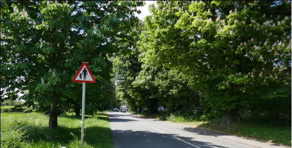
Figure 10: Avenue of Chestnuts, Cambridge Road
4.3 HERITAGE
History of Barkway
4.3.1 Barkway has a long history from prehistoric times when it was the site of a major crossroads, the east-west trading route taking advantage of the dry highlands of the scarp and the north-south track linking London with Cambridge. A small cache of Roman silver was found at the edge of the village and it subsequently appeared in an official document as part of the Domesday Survey. From then on it became one of the main stopping places between London and the North East until the decline of the coaching route in the mid-19th century.
4.3.2 Barkway was a major stopping point on the London to Kings Lynn via Cambridge route during the coaching age which encompassed the 200 years between the 17th and 19th centuries. During this time people travelled by horse-drawn coaches, often making journeys that were long and tiring as it was only possible to travel about 20-40 miles each day. There was a vast network of coaching inns to meet the needs of travellers, offering food, drink and accommodation. Barkway had a large number of inns, shops, alehouses and a brewery which catered for the local population as well as coach passengers. In addition, there was a what was known as a wagon wash (now called the Carriage Wash), a smithy which stood on the corner of Church Lane and a forge, part of The Old Forge on the High Street. Now only one inn, The Tally Ho, remains at the south end of the High Street. Some of the former coaching inns can, however, be identified by the wide archways which allowed the coaches to pass through into the stable yard behind the inn. Examples on the High Street are:
- The Royal Oak (41 High Street)
- The Bull (49 High Street)
Other former inns:
- The Chaise and Pair (1 High Street) survived into the 1990s but is now in private residential use as is The Three Horseshoes (19 High Street), now split into two private residences.
- The Wheatsheaf (62–64 High Street) was established in 1726 as The Angel Inn and was renamed in 1800. Extra stabling for The Wheatsheaf was provided in a field off the Royston Road. Later the name was used for "Wheatsheaf Meadow House" which was built on the site. It was subsequently demolished to build a small housing development (Chapel Close). This has a small garden, designed by a pupil at the school, which is called "Wheatsheaf Meadow Garden". It is said that the servants and grooms used to stay at the Royal Oak, and their employers at the Wheatsheaf.
4.3.3 By the turn of the 20th century, Barkway was, like so many other Hertfordshire villages, away from the main roads and therefore from the attention of the county authorities. Slipping further into decline, the population slumped as people sought their fortunes elsewhere. Today, all of Barkway's fifteen shops have gone, its twenty or so pubs and beer houses reduced to just one.
4.3.4 Barkway is a village with a past, but it is not without a future. Even to this day, its market history is brought to life each year, with the famous Barkway Street Market. For one day a year visitors flood to the village as we celebrate our history and sense of community spirit. History has made Barkway the beautiful village it is. Away from the major roads it remains mainly unspoilt and untouched by modern expansionism, a peaceful and tranquil village, but certainly not a backwater. The historic layout of Barkway High Street was researched and developed by Barkway Local History Group (see map in Appendix F.)
History of Nuthampstead
4.3.5 The hamlet of Nuthampstead, within the parish of Barkway, lies on high ground to the south of Royston on the extreme limit of the deposition of an ice-age glacier. Communities developed along this ridge where small lakes of water were located - at Nuthampstead and other places such as Barkway, Reed, Therfield and Kelshall. The presence of water, fuel in the form of wood, and food, in the form of game and arable, provided an ideal environment for settlements. The ridge offered a convenient route for cattle drovers taking their animals from as far as away Wales to the markets at Harlow and the coastal ports such as Harwich. These Iron Age trackways still exist, for example, opposite Barkway's Church Lane through to Nuthampstead, across the land at Little Cokenach and via Scales Wood which has always dominated Nuthampstead.
4.3.6 After the Battle of Hastings in 1066 and prior to the proclamation of William, a new king, Edgar, held the crown for about six weeks until the arrival of William in London. Edgar was the only member of the Saxon nobility to retain lands in England after the Conquest – one was a small plot in Great Hormead and the other was 180 acres in Scales and Nuthampstead.
4.3.7 There is an unsubstantiated report of Roman remains in Scales and, certainly, objects suggesting pre-Roman settlements have been found along the road leading from Morrice Green to Barley. Adjacent to the road lies Wynnel's Grove, the site of an early medieval chantry chapel and hospital, all traces of which, apart from the name, have now disappeared.
4.3.8 At Morrice Green were the brickworks of the Clinton family of Cokenach – their bricks were marked with the letter 'C'. Apart from ordinary house-bricks the works produced over 100 different designs of terracotta blocks. The brickworks closed in 1882 but the clay pits still survive as ponds and lakes. The farms at Morrice Green and Little Cokenach were built in the mid-1800s to designs drawn for progressive farmers and landowners. Both demonstrate unique and forward-thinking features such as cast-iron pillars, shutter windows and door frames.
4.3.9 Little Cokenach Farm stands adjacent to an early medieval moated manor site. Nothing remains of the timber building but the moat floods regularly and creates a ford across the roadway.
4.3.10 Scales Wood was cut back in 1944 with the arrival of the USAAF. A few of the buildings at the edge of the wood survive and form the row of houses along the south side of Park Lane. Further south stands The Woodman public house. Its history goes back to the late 1600s when the annual Nuthampstead fair was held on the land between it and Park Lane.
4.3.11 Further westwards along Bell Lane stands one of the two Nuthampstead Christian mission rooms. This example, an outlier of the Barkway parish church, has been preserved and is now a private dwelling.
4.3.12 Bell Lane is derived from The Bell public house (now a private dwelling) opposite White's Farm. Named after the White family, the farm was originally called, unsurprisingly, Bell Farm. The second mission room, that of the Non-Conformists, lay on the south side of Bell Lane. It was finally demolished in the 1960s and a house has been built in its place. Opposite are the three Dimsdale cottages. These are one of a group of five or six similar architect-designed buildings to be found in North Hertfordshire and South Cambridgeshire at Anstey (Cheapside), Melbourn, Foxton and Flint Cross. The plans were freely available to landowners and used to build dwellings for farm labourers, etc.
4.3.13 The straight road from Bell Lane to the site of the modern golf course was built by the USAAF in 1944. Until then, the road from Barkway to Nuthampstead passed the Bury at Nuthampstead Lower End. The Bury contains one of the oldest structures in Hertfordshire. This is the remains of a Saxon undercroft used for religious purposes. In the fields adjacent to the Bury can be seen the footprint of a small medieval community which possibly housed the staff of the lost religious establishment at the Bury.
4.3.14 Opposite the entrance to the Bury Farm stands a block of three cottages (now a single dwelling) closely connected with the Bentley family the last of whom died in 2004. These cottages, like many in Nuthampstead, were originally constructed in Barkway, then dismantled and finally re-erected on their present sites. This was a regular procedure, and the buildings can be easily identified by their frontages in external runs of fifteen and a half feet – the longest length of timber that could be carried by wagon without incurring punitive tolls.
4.3.15 Finally, the road to the golf course passes Brookfield Cottage. This was originally called Brickfield Cottage and was the site of extensive clay-pits, kilns and brick drying sheds. The end of its plot lay on the trackway to Barkway.
Designated Heritage Assets
4.3.17 The Plan Area comprises many listed heritage assets including Grade II and Grade II* listed buildings. A list of the heritage assets in Barkway is provided in the Barkway Conservation Area Character Statement. However, this relates only to those in the conservation area itself. The most reliable source is the search function on Historic England's website. Barkway Carriage Wash was awarded Grade II Listed Building Status (List Entry Number: 1476819) on 31 October 2023.
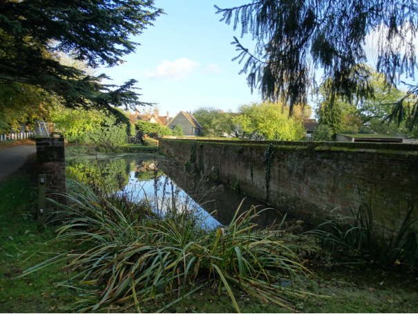
Figure 11: Barkway Carriage Wash (Grade II Listed)
4.3.18 Newsells is a small, beautiful hamlet located to the north of Barkway. It also has a large proportion of listed buildings surrounded by chalky fields, beech dells and charming houses.
4.3.19 Nuthampstead is a linear village, with houses of a wide variety of style, size and age, spread along the main street, some of which are listed. The Grade II Historic Park and Garden at Cokenach straddles the boundary of both parishes.
4.3.20 Barkway has been occupied continuously since prehistoric times as its appearance in the Domesday Book confirms and was once a major coach staging post between London and the North East. 25% of the houses in Barkway are listed buildings. This very high percentage gives Barkway a distinctive historic character.
(2) Policy BN HA1 Designated Heritage Assets
Development proposals which have an impact on designated heritage assets, including all listed buildings and the Grade II listed Historic Park and Garden of Cokenach, will take account of the historic fabric, the significance of the asset and the contribution of its setting to that significance. A statement setting out any adverse impacts on the asset and its setting, along with any proposed mitigation measures will be required. Proposals must preserve, or where possible enhance, the asset and its setting. Proposals to restore, enhance and facilitate good conservation management through a Conservation Landscape Management Plan for Cokenach will be encouraged.
Non-Designated Heritage Assets
4.3.21 The Carriage Wash, now a designated heritage asset is the responsibility of Barkway Parish Council who are advised by HCC's Countryside Management Service (CMS). Concern has been expressed that the Carriage Wash requires "dredging". The Parish Council has spoken to CMS about improving access and the condition of the Carriage Wash and Chalk Pit sites. CMS have promised to work with the Parish Council to create an approved plan to improve both sites, possibly with the aid of a Heritage Lottery grant.
4.3.22 The 398 Bomber Group and 55th Fighter Group Museum is situated next to The Woodman Inn in Nuthampstead. The museum provides an important record of WWII in village history, illustrating the operation of the air force base with maps and photographs. The stories of the airmen and their families are carefully presented; the artefacts displayed tell their own stories. There are several WWII buildings still remaining in the village and a memorial to the WWII airmen is situated near to The Woodman Inn which includes a unique collection of photographs from the period.
4.3.23 There are also a series of other non-listed buildings and assets which are of local historical importance and contribute greatly to the history and character of the village including a World War II anti-tank concrete pillar.
4.3.24 Several other non-listed buildings and barns in Barkway are also important to the appearance and setting of the area including Flint House and Chestnut Cottages on Cambridge Road and, in the High Street, the Chaise and Pair (no. 1) the Coach House, Ashgrove, Stallibrass Almshouses, and The Tally Ho public house. Many of these buildings are also mentioned in the Barkway Conservation Area Character Statement. In addition, the owners of Barkway House are in the process of reinstating Victorian water gardens to reinforce the historic nature of the village and these too should be preserved.
4.3.25 NHLP Policy HE3: Non-designated Heritage Assets and its supporting text is limited in its scope. There is no mention of Hertfordshire Gardens Trust and their work with illuminating the history of historic parks and gardens, or the opportunity of identifying non-designated heritage assets in a Neighbourhood Plan in accordance with guidance from Historic England. In the interim before a review of NHLP includes this type of heritage asset, Policy BN HA2 Non-Designated Heritage Assets highlights non-designated heritage assets identified by the community through the process of consultation on the Plan. Archaeology is often overlooked but its importance in Barkway and Nuthampstead is recognised by its inclusion in this policy.
4.3.26 In addition to the designated Historic Park and Garden at Cokenach, there is also a historic landscape of note at Newsells Park. The park includes an ornamental garden and paddock. The gardens were the work of Richard Woods, a contemporary of Capability Brown, who began working at Newsells in 1763. Newsells is included as a non-designated heritage asset in this Plan.
4.3.27 Photographs, descriptions, grid references and other supporting information containing the rationale for the inclusion of the non-designated heritage assets in this Plan can be found in Appendix G.
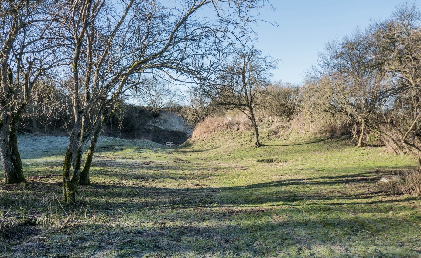
Figure 12: Non-designated Heritage Asset - Chalk Pit
Archaeology
4.3.28 There is strong evidence that Barkway has a long history of settlement as it is in a strategic position between London and Cambridge. In particular, there are remains of a Norman motte and two baileys, a defensive site with ditches surrounding it, believed to have been used by William the Conqueror when moving to suppress the rebellion of Hereward the Wake. The Lord of the Manor of Newsells at this time was Eudo Dapifer, steward to William the Conqueror.
4.3.29 Roman artefacts have been found in and around the village, including the 'Barkway Hoard' in the British Museum. This dates from the 3rd to 4th century AD and consists of several items, including a copper alloy figure of Mars and silver plaques, which are believed to have come from a temple dedicated to the god Mars. These items were thought to have been buried at the time to avoid being plundered by Anglo-Saxon raiders. Local residents have also found both Roman and Georgian finds in and around Barkway. A sample index of some of these items is shown in Appendix H.
(2) Policy BN HA2 Non-Designated Heritage Assets
The following non-designated heritage assets have been identified as having local historic importance:
- The Chalk Pit, Royston Road
- World War II anti-tank pillar, High Street
- Flint House and Chestnut Cottages, Cambridge Road
- The Chaise and Pair, 1 High Street
- The Coach House, High Street
- Stallibrass Almshouses
- Ashgrove
- The Tally Ho Public House
- Newsells Historic Park & Garden
Development proposals which affect these heritage assets, or are within their setting, should avoid or minimise any harm to their significance. A proportionate description of their significance and the impact of the proposals on it must be provided by applicants, to enable a balanced judgement to be made, having regard to the scale of any harm or loss and the significance of the asset.
Development proposals affecting a site with potential archaeological interest shall be accompanied by an archaeological desk-based assessment informed by an analysis of the Hertfordshire Historic Environment Record and, where necessary, a field evaluation.
Conservation Area
4.3.30 The conservation area in the village of Barkway is characterised by small, thatched cottages and Georgian mansions. In recent years, new infill development sympathetic to the character of the conservation area has been welcomed.
4.3.31 At the north of the village, around Royston Road, is a more modern development of some 65 houses. It was originally built by the Council between 1946 and the 1980's. In addition, there are a small number of later additions. Also, at the northern end of the B1368 lie the recreation ground, pavilion, village hall and village social club together with some 20th and 21st century houses.
4.3.32 St Mary Magdalene Church, parts of which date from the 13th century, is Grade I listed. It is sited on Church Lane, a narrow lane leading west from the centre of the High St and ending only in public footpaths. Church Lane also contains Manor Farm, some listed properties and the ancient Carriage Wash, a significant historic feature of the village.
4.3.33 To the east of the High St near the school is Burrs Lane, a development of eight post WWII houses and bungalows, augmented by a development of six properties. To the east again, but further south down the High St, is Townsend Close, a cul-de-sac of 16 chalet bungalows and two houses built around 1965.
4.3.34 Yet further south is Gas Lane, a small and narrow restricted byway leading to a mixture of six small and large houses of various ages and a field of allotments.
4.3.35 At the southern end of the village are The Tally Ho public house and the garage/filling station. To the east is the road to Nuthampstead. Finally, on the southern end of the High Street/B1368 are a number of 20th century houses.
4.3.36 The Barkway Conservation Area is centred on the High Street. The house designs are in a mixture of styles following various stages of economic development across 600 plus years. It contains many Grade II listed buildings and a few Grade II*s. Along the street, near the school, is the village pond.
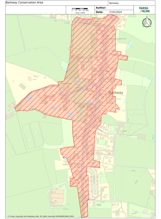
Figure 13: Barkway Conservation Area (from NHLP map layer)
4.3.37 The Plan supports new development that is in keeping with existing architectural styles (other than unsympathetic 20th century infill). These styles include timber framing, pargetted walls, thatch and red-brick and maintaining the absence of street lights in the conservation area.
(1) Policy BN HA3 Barkway Conservation Area
The character or appearance of the Barkway Conservation Area and its setting will be preserved and, where possible, enhanced in accordance with the Barkway Conservation Area Character Statement.
4.4 LEISURE AND RECREATION FACILITIES
4.4.1 The Plan supports the community aspiration to expand the range of social activities and to introduce new sporting opportunities.
4.4.2 Barkway displays a strong community spirit, hosting a variety of entertainments in the village hall, with an active social club, a recreation ground with pavilion, a regularly attended 13th century church and a chapel. Cokenach Cricket Club has a considerable history. Between the wars when the Crossman family owned Cokenach the ground was one of the finest playing surfaces in the county, with country house and minor counties cricket played there. Cokenach CC is still a very active club, running two senior sides, and has a vibrant youth policy.
4.4.3 The village community unites to support the annual Barkway Street Market which attracts traders, entertainers and visitors from a wide area. The village is surrounded by a network of footpaths crisscrossing agricultural land, offering a variety of scenic walks.
4.4.4 The church and chapel remain very active with the former being used for concerts and lectures as well as attracting visiting bell ringers. The village hall continues to provide a facility for use by the villagers and visitors. Barkway First School provides our children with a good primary education. Despite having no village football team of our own, the football pitches on the recreational area are in high demand from neighbouring villages. The last pub in the village, The Tally Ho, continues to trade in a time when village pubs are closing at an ever-increasing rate, and remains an important community asset. We are currently redeveloping the Reading Room to improve access and upgrade facilities to enable us to use the space for village groups and organisations that continue to contribute to village life.
4.4.5 Nuthampstead has a popular pub, the 17th century Woodman Inn, an essential meeting point for the village. Other facilities include a clay pigeon shooting range, a model aircraft club, a golf driving range, a fishing pond and a museum.
4.4.6 The overall conclusion from the survey conducted in 2014 is that the residents enjoy living in Barkway and Nuthampstead. Respondents highlighted their enjoyment of country walks, extensive views, friendly neighbours, a sense of community, village clubs, recreational facilities and an active church and chapel, all of these in a rural location with easy access to Royston, Cambridge and London.
(1) Policy BN L1 Valued Community Assets
The following facilities have been identified as especially valued by the community:
- The Tally Ho pub
- Barkway Service Station
- Walsh's Garage
- St Mary Magdalene Church
- Barkway Chapel
- The village hall
- The Reading Room
- The pavilion and community room
- Barkway Social Club
- Barkway 1st/pre school
- The Woodman Inn
- Nuthampstead Museum
Permission for a change of use of these facilities must be supported by evidence that the facilities were no longer used with no likelihood that re-use was possible or desirable, or that their active use was to be replaced elsewhere and would still benefit village residents, in accordance with North Hertfordshire Local Plan Policy HC1.
Alternative provision must be sustainable and therefore provided within walking or cycling distance of the existing facility.
4.4.7 The Woodman Inn is the only community facility in Nuthampstead, and The Tally Ho is the last remaining pub in Barkway. The loss of pubs to residential conversions, alternative community use or restaurant use has highlighted the importance of these facilities, particularly in rural communities. The NPPF is helpful in describing the role of pubs in supporting a prosperous rural economy (paragraph 88 d) where it says that planning policies should enable the retention of public houses; and promoting healthy and safe communities (paragraph 97 a) where it recognised pubs as a community facility.
4.4.8 Pubs provide places where local people are encouraged to interact, and this promotes social cohesion. Pubs are local businesses and can support the rural local economy in Barkway and Nuthampstead. They provide a community facility and a social facility and both pubs in the Neighbourhood Plan area are part of the local culture.
4.4.9 Both pubs also have heritage value. The Woodman Inn is a Grade II listed building. The Tally Ho has been included in this Plan as a non-designated heritage asset.
4.4.10 NHLP refers to pubs as providing residents in rural areas with access to an important service, especially for those less mobile. Policy ETC7 sets a test that the loss of services will only be permitted if it can be demonstrated that the unit is no longer required to meet the needs of the local community, including through evidence of at least twelve months active marketing. It also sets a distance of 800 metres between similar services implying that if there are no similar services within that distance, the change of use of that unit will not be permitted. The Tally Ho and The Woodman are 3km apart. These pubs are their nearest neighbours. NHLP policy ECT7 is not specific enough to relate to pubs and therefore Policy BN L2 is necessary.
Policy BN L2 Existing Pubs
The conversion of existing pubs (The Tally Ho in Barkway and The Woodman Inn in Nuthampstead) to any other uses will be strongly opposed unless, following viability assessment and public consultation, it can be clearly demonstrated that they are no longer viable and no longer required by the community.
Proof of viability must be robust and could include CAMAR's Public House Viability Test or be supported by a District Valuer Services report.
Alterations and extensions to public houses to support their continued use as such will be supported provided that there is no unacceptable adverse impact on:
- the historic character of the building or area (where relevant), or
- the amenities of neighbouring properties.
Development proposals for redevelopment of associated accommodation, facilities or development within the curtilage of these public houses, that would compromise their operation or viability will be resisted.
Community Hub
4.4.11 Existing premises will be investigated to see how they can contribute to the continuing development of the community hub, bringing together a range of services and activities for the local community. Exploratory discussions have been held with local community groups including the village hall and social club committees, St Mary Magdalene Church, Cokenach Cricket Club, Barkway Community Group, District and County Councillors, North Herts Council's Executive Member for Local Engagement, Hertfordshire County Council's Public Health Service, Granta Medical Practices and Hertfordshire Police. The creation of a community hub is identified in the Action Plan in Appendix O.
4.4.12 Services that could be accommodated in the community hub would include: Council advice services, drop-off and pick-up library facilities, social space, incorporating a memory café, IT facilities for those without access to superfast broadband, workspaces for artisan businesses, a community garden, social prescription health services, a drop-in facility for police to maintain contact with local residents, joint recreation, sport and leisure facilities shared between the community and the local school federation, and space for charities and social enterprise to provide services. The facility would promote health, well-being and social inclusion for the village and surrounding area.
Policy BN L3 Development of the Community Hub
Proposals that would contribute positively to the development of the community hub to serve the villages of Barkway and Nuthampstead will be encouraged. The first option to be considered would be extensions/improvements to existing facilities. Such proposals must demonstrate how they will accommodate visitors of all ages and abilities, including those with dementia.
Leisure Facilities
4.4.13 Barkway and Nuthampstead have several privately owned facilities for leisure pursuits which are popular. Barkway golf club, the golf driving range, the clay pigeon shooting range and Nuthampstead fishing pond are regularly used recreational facilities in the community which they want to retain.
4.4.14 Barkway Stud utilises a number of paddocks throughout the village, but the central stables lie at the bottom of Burrs Lane. A successful working stud farm breeding ponies for children, it also provides space for livery and has a ménage in which horses can be schooled. Cokenach cricket ground lies in beautiful surroundings on the edge of the Cokenach Estate. Having moved from its previous ground, the club now has a new pavilion which can be hired for events. The teams (of all ages) play a full calendar of fixtures in the season and there is a thriving coaching programme for youngsters. Many former members now play at District and County level and the club's ECB coaches work with local schools to encourage participation in the sport.
Recreational Open Space
4.4.15 The main recreation area in Barkway is a very well-used resource for all ages in the village. The playground provides a safe area in which children can socialise and exercise. The football pitches are used every weekend in the season by local teams – and more informally throughout the year for sport. On November 5th each year the village firework display draws a very large number of villagers and people from further afield to watch. In the summer, biennially, Music on the Rec is a fun occasion with live music, again drawing large numbers of participants, and B in the Park treats younger villagers to a variety of entertainment and activities including camping.
4.4.16 The communal area behind Windmill Close is a pocket of open land in a residential area which has now been given by NHC on a long-term lease to the Parish Council. It has been used by generations as a safe place in which children can play and also as an area for all ages to hold community barbecues and other social gatherings. The area is accessed through gates in the back gardens of the residents, via a footpath leading from Windmill Close, and is easily accessible from the BK2 housing development.
4.4.17 The Gas Lane allotments have been a feature of the village for many decades. The plots look out over open land and have provided local people with the opportunity to grow their own fruit and vegetables on fertile, productive land. With the current interest shown by young and old in organic produce, the allotments are an alternative to the weekly trek to the markets and supermarkets of nearby towns and, of course, a useful way of keeping fit.
4.4.18 NHLP policy NE5 contains criteria that would guard against loss of any of these spaces unless they are surplus to requirements and this is clearly justified, and that their loss is mitigated by the re-provision of the open space, or in exceptional circumstances, a financial contribution is made towards a new open space.
4.4.19 Neighbourhood Plan Policy BN L4 clearly identifies the open spaces, used for recreation, that are important to the community in Barkway and Nuthampstead.
Policy BN L4 Protected Recreational Open Space
The following areas allocated as Protected Recreational Open Space and identified on the Policies Map, are particularly important to the local community:
R1 – Recreation ground including football pitches & children's playground
R2 - Communal area behind Windmill Close
R3 - Allotments in Gas Lane
Proposals for development on this land will only be permitted where it retains or enhances the provision, quality and accessibility of the open space in accordance with Policy NE5 in NHLP.
4.5 LOCAL ECONOMY
4.5.1 Self-employment and home-based working are features of the local economy. 23% of Nuthampstead residents and 17% Barkway residents are self-employed. Employment opportunities based within Barkway and Nuthampstead are restricted.
4.5.2 In Barkway, employment is provided by two motor garages, domestic and gardening services, agriculture, Cokenach Estate, the school, the public house, a small equestrian business, and Barkway Dog Park and Retail (offering a facility that can be booked to train and exercise dogs safely and a shop selling pet supplies. In Nuthampstead, as well as agricultural roles related to farming and pest control, there are a number of manufacturing and service providers. Two small industrial estates, one partially vacated, have a range of businesses. The partially vacated site, Bell Farm Industrial Park, was granted outline planning permission (23/00549/OP) in September 2023, for the erection of 9 dwellings following the demolition of industrial buildings. The Nuthampstead Shooting Ground is also both an employer and a leisure/recreational facility, and the Woodman Inn is also a key employer. In Newsells, Newsells Park Stud is a key business with international importance in breeding successful racehorses. The stud is one of the main employers in the area. The recently launched Newsells Park Winery is a good example of a new business welcomed into the Neighbourhood Plan area.
4.5.3 In a survey conducted in 2014, many respondents cited the lack of a village shop as one of the drawbacks of living in Barkway; however, residents consulted in 2019 were concerned not to affect the viability of Barley Post Office and Stores. Consequently, any proposed retail developments should demonstrate that not only would they be viable in their own right, but that they would not undermine the business in Barley.
4.5.4 The community supports the expansion of existing and creation of new viable retail and commercial facilities, not operating during anti-social hours, within Barkway and Nuthampstead, which are sympathetically designed to blend in with the historic buildings in the area. There must be no negative impact on existing residential properties or other facilities. An emissions reduction plan will be provided with specific reference to any risk of pollution of the River Quin.
(1) Policy BN E1 Preserving and Developing Local Employment Opportunities
Development proposals that would support the retention of existing businesses and the development of new local employment opportunities within the settlement of Barkway will be encouraged, including artisan businesses, provided that they do not conflict with other policies in this plan. In Nuthampstead, rural business will be supported in accordance with policies on rural areas beyond the Green Belt.
Expansion of existing industrial operations should be accompanied by an appropriately detailed emissions reduction plan and the adoption of a 'best practice' approach to emissions control and waste management. This must refer to any risk to further pollution of the River Quin.
Proposals for the diversification of agricultural businesses will be supported provided:
(a) The development is ancillary to the agricultural business or
(b) The development supports the viability of the existing farm business
(c) The development does not include domestic housing for sale.
4.5.5 This Plan supports the enhancement of broadband connectivity for the villages. A problem has been highlighted with properties close to the BT exchange that is affecting broadband performance. Negotiations with BT appear to have resolved this problem (also see Appendix O- Action Plan). It is important to require Fibre To The Premises (FTTP) rather than just Fibre To The Cabinet (FTTC) which does not connect to business premises or residential properties.
Policy BN E2 Internet Infrastructure
Provision of facilities to support the delivery of efficient and effective landline, fibre optic broadband to premises (FTTP) and mobile coverage throughout the parish will be encouraged, provided they are sensitively designed and located in accord with other policies in this Plan.
4.6 SCHOOLS AND EDUCATION
4.6.1 There are currently surplus places at most age levels at local schools. The exception is for nursery and reception in the Barley and Barkway VA Church of England First Schools Federation for which only 15 places are available for each year's intake, leading to children having to be turned away. A major redevelopment of the Barkway premises is required to increase capacity to at least 25 for nursery and reception and to update the teaching and learning environment of the school. Pressure on the places for these younger age groups would increase if BK3 were to proceed.
4.7 CRIME AND SAFETY
4.7.1 Barkway and Nuthampstead generally have low levels of crime, although there has been an uptick in rural crime in Nuthampstead including the theft of farm machinery and a handful of incidents associated with a partially vacated industrial site. There is likely to be a significant reduction in such issues arising when the site is redeveloped for housing. The majority of crimes committed in the area are traffic related, including traffic speeding; other key issues are fly tipping and hare coursing. The reasons for these crimes may be attributed to the remoteness of the village and the nature of the road network. In the survey conducted in 2014, 29% of respondents said that they were concerned about crime and 89% of respondents said that they would support traffic calming measures.
4.7.2 Hertfordshire Police are considering the role they may be able to play in the community hub, possibly using the hub as a drop-in point to keep in touch with the concerns of residents.
4.8 HEALTH
4.8.1 Barkway and Nuthampstead residents have to travel outside Barkway and Nuthampstead for appointments with doctors and to access emergency services; the nearest GP surgery is in Barley. In a change since residents were consulted in 2014, the Barley practice is now part of Granta Medical Practices which has 40,000 patients. The greater number of staff and flexibility in their deployment means that the Barley practice has sufficient capacity for local residents (although appointments might well not be in Barley itself) and could accommodate additional patients if BK3 were to proceed.
4.8.2 The bus service from Barkway to the surgery in Barley is infrequent and there is no bus service for Nuthampstead. Most residents rely on private transport to access the surgery in Barley or drive to Royston or Buntingford for appointments. In bad weather, access to these services can be problematic.
4.8.3 These issues could be resolved to some extent by ensuring that residents have access to improved broadband services which will enable them to use Skype as an alternative to attending the doctor's surgery, thus decreasing the need to travel.
4.8.4 The Barley Surgery has access to a "social navigator" who can prescribe social interventions, for example, exercise to help tackle problems with obesity. In support of the Plan's aspirations to build in health and wellbeing throughout the community, the opportunity is being explored to offer facilities in the community hub to promote the health and wellbeing of residents through social interventions organised by the social navigator.
4.9 TRANSPORT & PARKING
Public Transport
4.9.1 Residents in Barkway and Nuthampstead lack access to a genuine choice of transport modes and most of them rely on private vehicles.
4.9.2 In Barkway, there are only two bus services located within walking distance of the new housing on sites BK1 and BK2 and site allocation BK3 (i.e. bus 27 operating only on Wednesdays and bus 18, operating from Monday to Saturday at low frequency) both of which are unreliable for commuting to work, social activities, school runs and shopping. HertsLynx is a new on-demand bus service that could, if successful, improve public transport in the villages. Currently there are several 'virtual' bus stops in Barkway village, one in Nuthampstead, and two near Newsells. Improvements to transport provision would be sought from new housing development through S106 agreements and a traffic survey, considering traffic at peak times. Nuthampstead has no regular bus service. See Action Plan in Appendix O for actions to review and improve public transport.
4.9.3 Financial contribution to support the delivery of community autonomous vehicles to give more independence to the elderly or disabled or alternatively a regular village minibus would be sought where appropriate. Provision of communal electric car charging points in Barkway village would be welcomed as an option for residents without private drives to have electric cars.
(1) Policy BN T1 Sustainable Transport Provision
Major development proposals must positively contribute towards improvements in the quality of local transport services in order to ensure that residents have access to sustainable modes of transport.
Financial contributions will be sought for:
- Provision of communal electric car charging points in Barkway village
- Provision of a shared community autonomous vehicle
- Contributions toward a village minibus
Traffic issues
4.9.4 Roads in Barkway and Nuthampstead are generally narrow, yet they are having to support an ever-growing amount of traffic and to cope with on-street parking which reduces their width. The health and wellbeing of the community is negatively impacted by the resulting congestion and the associated air and noise pollution. The safety of the most vulnerable road users (i.e. children, the elderly, cyclist and horse riders) is at risk due to the limited number of footpaths, and narrow roads.
4.9.5 The survey conducted in 2014 revealed that traffic issues are a major concern for a large number of residents. 90% of respondents were concerned about excessive speed of traffic through the village of Barkway and 86% of respondents indicated that they have concern about HGVs passing through the village. The safety issues along the road network were raised by 85% of respondents and 89% of respondents said that they would support traffic calming measures.
4.9.6 The feedback was confirmed by a follow-up survey in 2019 in which the majority living in Barkway High Street thought there were significant traffic issues through Barkway, causing excessive noise (some villagers are unable to sleep in bedrooms facing the High Street) and damage to vehicles parked along the street, with many vehicles breaking the 30mph limit. In addition, there was concern about the damage to historic buildings due to the continuous vibrations from heavy traffic.
4.9.7 The proposed development at site BK3 is likely to add approximately 280 extra cars within Barkway (assuming two per household) which would result in 560 additional daily car movements through the village if each makes only one return journey per day. This would add to the traffic issues already identified in the High Street.
4.9.8 Having been built along an old coaching road (the B1368), Barkway is particularly vulnerable to the increasing volume, weight and speed of vehicular traffic. The village road network is narrow and is characterised by many turns. Safe footpaths, particularly those to local schools, are also very limited. Despite these limitations, many vehicles cut through Barkway to avoid the A505 in Royston, including an ever-increasing number of heavy goods vehicles (HGVs) which also damage roadside verges. The traffic issues are further exacerbated by on-street parking, which makes the roads narrower and more difficult to navigate. The limited number of footpaths in certain areas makes it unsafe for all road users, particularly pedestrians.
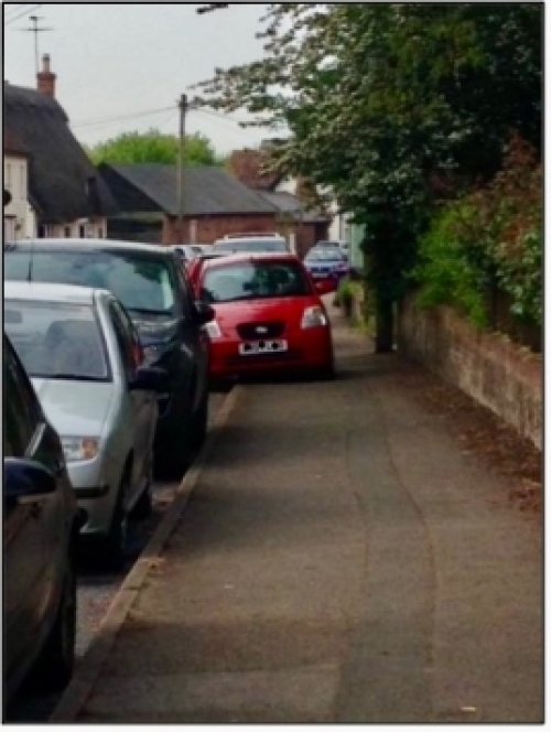
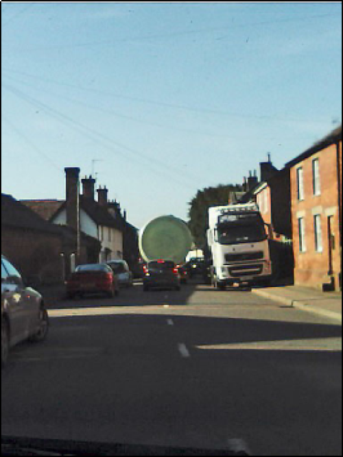
Figure 14: Pavement blocked by parked cars and lorries
4.9.9 The junctions particularly affected are Royston Road, Royston Road junction with High Street and Cambridge Road, Cambridge Road, Nuthampstead Road junction with London Road, London Road through High Street to Cambridge Road, and Buckland Road junction with London Road.
4.9.10 These traffic issues also have a negative impact on the local economy which includes hosting of tourists who are attracted to a supposedly peaceful village only to find that noise and vibration from traffic through Barkway spoils that tranquility.
4.9.11 To mitigate against the above traffic issues in such a way as to support community health and wellbeing, a number of solutions will be implemented. These include decreasing vehicular speeding at key junctions within the 30-mph limit, seeking opportunities to provide off-road public parking provision, creating No Waiting zones outside schools and limiting the number of heavy vehicles going through the villages. Projects to create more footpaths will be supported, particularly in and around housing site BK3. See Action Plan in Appendix O for proposed actions to improve footpaths.
Policy BN T2 Mitigating Traffic Impact
Development proposals which will improve pedestrian safety, reduce existing congestion and improve traffic flows throughout Barkway and Nuthampstead will be supported.
Rights of Way
4.9.12 There is a good network of public rights of way through the parishes, enabling residents and visitors to access the countryside and avoid walking along the narrow, dangerous roads.
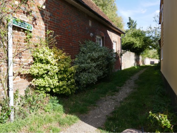
Figure 15: Public Footpath From Barkway To Nuthampstead
4.9.13 There is no safe walking or cycling route from Nuthampstead to the school in Barkway, so children are dependent on their parents, or guardians, to drive them to school.
(3) Policy BN T3 Public Rights of Way
Development proposals that would lead to the loss or disruption of Public Rights of Way will not be permitted. Proposals to support the use of these Public Rights of Way by integrating them into larger network will be encouraged.
(2) Policy BN T4 Safe and Accessible Walking and Cycling Routes
Major developments should feature an appropriate and proportionate package of safe and attractive walking and cycling routes that link schools, services and facilities such as shops.
The location and access arrangements of new schools should promote pedestrian safety by widening footpaths, ensuring that they are well lit, and by reducing vehicular congestion.
Proposals which incorporate travel plans that include measures to improve the safety of local roads leading to local schools will be supported.
Parking
4.9.14 It is important to include sufficient off-street parking in all new developments because there is a very limited public transport system and residents in this area are more dependent on private cars than in other parts of the District (see section 1.8 BASIC STATISTICS). Car ownership in Barkway has shifted between the 2011 and the 2021 census, with slightly more households with no car, ownership of 2 cars decreasing by 6% while households with 3 or more cars have increased by 5%.
4.9.15 The comparison between Barkway and North Hertfordshire is shown in the table below. The percentages for no car and 1 car total 21% higher for North Hertfordshire and the percentages for 2 cars and 3+cars are 21% higher for Barkway.
|
No. of cars/% car ownership Barkway and North Hertfordshire 2021 |
% Barkway |
% North Hertfordshire |
% Difference |
|
No car |
7 |
15 |
-8 |
|
1 car |
30 |
43 |
-13 |
|
2 cars |
40 |
31 |
+9 |
|
3+cars |
23 |
11 |
+12 |
4.9.16 The roads in the area are also generally very narrow, providing limited availability for on-street parking. These special circumstances justify a slightly higher standard of car parking spaces per dwelling than set out in the NHLP. A minimum of two off-street parking spaces per new dwelling will be required, unless a lower standard can be justified.
4.9.17 Particular issues are: parking on pavements creates a hazard for pedestrians; parking outside the school is hazardous; insufficient off-road parking is available for residents; residents parking on roads instead of their own drives or garages; cars parked too close to junctions.
(1) Policy BN T5 Vehicle Parking in Residential Development
New residential development must seek to minimise on-street parking in Barkway and Nuthampstead particularly in Barkway High Street, Cambridge Road, Royston Road, Church Lane, Chapel Close, Windmill Close and Periwinkle Close.
Due to the limited public transport facilities in Barkway and Nuthampstead, household car ownership is higher than the county average and off-street parking for new development therefore needs to be at least two spaces per dwelling unless there is a clear justification for a lower standard.