Preston Parish Neighbourhood Plan 2018 - 2031
Appendices
A. People
A.1 The Neighbourhood Plan Team
Our thanks to all of the team.
The Steering Group
- Wally Steele (Chairman)
- Di Day (Vice Chair)
- Margaret Trinder (Parish Council Liaison)
- Fay Higgin (Clerk)
- Malcolm Gomm
- Alexandra Higgin
- Liz Hunter
- Rae Reynolds
The Volunteers
- Residents who deliver every month the Church and Village Newsletter to all households in the parish:
Margaret Cashin, Patrick Diamond, David and Frances Drew, John and Stephanie Healey, SueKellard, Ann Lowle, Doreen Sansom, Ros Welch
Production of newsletter: Howard Trinder – editor. Liz Madden – arranges photocopying in the office at PHC. Doreen Sansom – allocates the copies needed for each ‘delivery area’.
- Residents who volunteered to deliver and to collect the NP Questionnaires, in January and February 2017:
All the people above, and in addition, the following:
Richard and Di Blockley, Adrian and Chris Hardy, Mike Kellard, Ita Leaver, DavidMorgan, Christina Nurthen, Sandra Palmer, Meta Reeves, Richard Woolfson.
- Residents and friends of the parish who have made other contributions:
Frances Drew - the 63 Listed Buildings of the parish
Dr. Jane Sears - the natural environment of the parish
Philip Wray (author of A history of Preston in Hertfordshire) – who gave permission for use of his research, reviewed aspects of our research and analysis.
A.2 Other Individuals and Organisations
Our thanks to the other people and organisations who we consulted that provided information and/or services in the development of our Neighbourhood Plan.
Becky Lewis, Insight Fountain
Campaign to Protect Rural England (CPRE) Hertfordshire Branch
Claire Skeels, North Herts District Council (NHDC)
Colin Kendal, Creamers Print and Design
Donna Moles, Moles Consulting
English Heritage
Hertfordshire Environmental Record Centre (HERC)
Hertfordshire Historic Environment Records (HHER)
- which is a section of the Planning Dept. of Hertfordshire
County Council (HCC)
Herts and Middlesex Wildlife Trust
Jacqueline Veater, Independent Planning Consultant
Kate Harwood, Conservation and Planning Officer - Hertfordshire Gardens Trust
Keith Fitzpatrick-Matthews, Archaeology Officer, NHDC Museum Service
Ordnance Survey Office
Preston News Service (PNS)
Princess Helena College
Wally Steele Limited - Website, Graphic Design, Photography and IT Support.
Our thanks also go to the communities and steering groups of other neighbourhoods who have produced plans which we used as a resource: Braughing, Mattishall, Pirton, Tattenhall and Walkern Parish Councils – we have read and learnt from your Neighbourhood Plans.
B. Survey
The survey provides an important part of the evidence base for the Preston Parish Neighbourhood Plan. As a major part of the consultation process it is detailed in the Consultation Statement.
Electronic copies of the questionnaires (Adult, Young Resident and Under 10’s) and the analysis report are available as separate documents.
This plan and all accompanying documents are available to view and/or download from the Preston Parish Neighbourhood Plan website as PDF files. They will also be available from the Neighbourhood Planning section of the North Herts District Council website.
At the time of this Submission Draft the URLs for the relevant web pages are:
www.preston-np.org.uk/your-say/
www.north-herts.gov.uk/approved-neighbourhood-areas-preston
The results presentation is included as an Appendix to the Consultation Statement.
C. Environment
C.1 ContextThis small and oddly shaped parish stretches about 3 miles across the Chiltern escarpment. Variations in altitude and gradient, and in soil type and depth, give a constant change in scenery, as one travels through the parish, on foot, horse, cycle or by car. These subtle changes are reflected in the pattern of habitats which now exist. Throughout at least ten centuries, people have lived and worked in this short and narrow slice of Hertfordshire’s countryside.
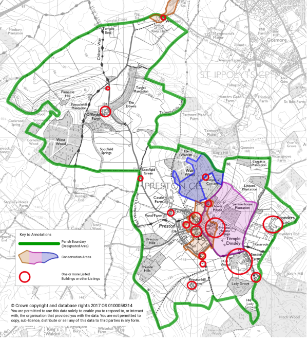
As discussed further in this appendix the parish contains 2 Conservation Areas, a Registered Historic Park and Garden, 63 Listed Buildings and Structures, as well as 1 Site of Special Scientific Interest.
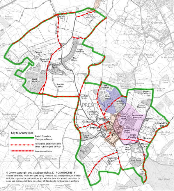
Footpaths, Bridleways and Green Lanes
There is a well used network of Public Rights of Way (including part of the Chiltern Way, many footpaths, bridleways and green lanes) as well as permissive paths through the churchyard to the Millennium Meadow and across a field in the grounds of Princess Helena College.
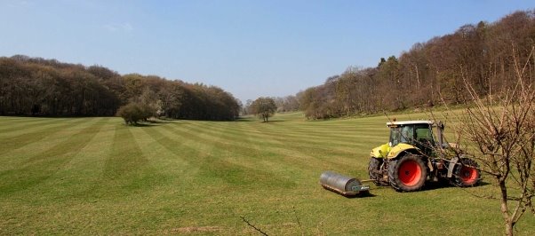
Views and Vistas
The residents value the views and vistas afforded by our setting. Below is a map from the survey which is indicative of the views, not definitive.
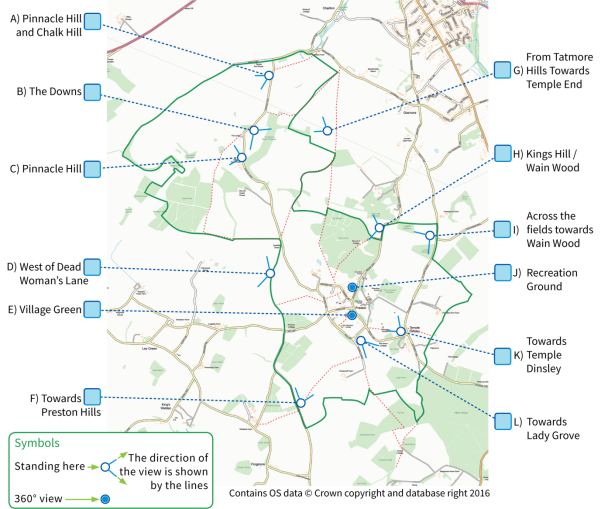
The following photographs illustrate some of the views and vistas from the above map and the Distinct Villages map on page 63

Distinct Villages
The views from Preston across open countryside are highly appreciated by residents and visitors alike. To the east and north in particular they stretch beyond the neighbouring town of Hitchin to open countryside. From Sootfield Green and Poynders End the Sandy Heath Transmitting Station, some 15 miles (24 Km) to the north as the crow flies, can be seen. To the west the views flow down and across the valley to where cows and sheep graze and to woodland beyond.
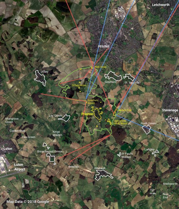
Some of the views are suggested by straight lines. Preston Village, smaller settlements and individual farms/houses within the parish are shown with a yellow border. Preston Parish boundary is shown in green. The more noticeable of the neighbouring settlements have a white border.
Areas, habitats and species with legal protection.
This Appendix gives data which supplements that given in Section 10, Environment and Heritage, in the Preston Parish Neighbourhood Plan.
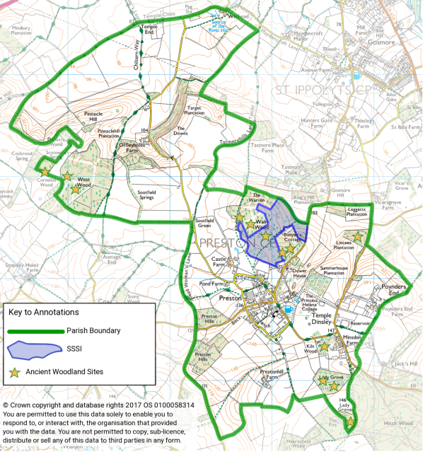
Site of Special Scientific Interest
Natural England has designated part of Wain Wood as a Site of Special Scientific Interest under Section 28 of the Wildlife and Countryside Act 1981 (shaded blue on the above map). It is an area of diverse flora and ancient deciduous woodland, known to have existed before 1600. The SSSI zone is only 19.03 hectares of the total wood of 31.02 hectares. Felling and removal of conifers in the summer of 2017 from the areas of ancient woodland surrounding the SSSI zone may enrich the biodiversity of this valuable habitat.
The details of the designation (as of December 2017) are as follows:
Wain Wood (TL 180255, Area: 19.2 ha, 47.4 acres) is the only SSSI in the parish. An ancient seat natural oak/hornbeam (Quercus species/Carpinus betulus) woodland, which is notable as it is near the northern limit of its natural range, and is a habitat that is now much reduced in extent nationally through woodland clearance or felling and restocking with conifers.
The stand comprises mature pedunculate oak Quercus robur and sessile oak Quercus petraea with hornbeam standards in the south and wild cherry Prunus avium frequent in the north. Thinly developed hornbeam coppice dominates the shrub layer throughout with elder Sambucus nigra also present. Here the sparse ground flora is composed of bluebell Hyacinthoides non-scripta, bramble Rubus fruticosus, bracken Pteridium aquilinum and bryophytes. A disused pit near the centre of the wood is surrounded by standard ash Fraxinus excelsior and wild cherry with abundant dog’s mercury Mercurialis perennis as ground cover.
A damp open ride in the south of the wood is characteristic of unimproved acidic grassland with sheep’s sorrel Rumex acetosella, yellow pimpernel Lysimachia nemorum and common centaury Centaurium erythraea. Elsewhere, drier more base-rich conditions support a ride flora indicative of calcareous grassland. Species present include field scabious Knautia arvensis, hairy St John’s wort Hypericum hirsutum, lady’s mantle Alchemilla filicaulis and eyebright Euphrasia officinalis.
The wood is said to support an interesting butterfly community, including the near threatened and scarce purple hairstreak butterfly, Thecla quercus, but there are no recent records.
The accounts of the woodward, John Merrit, 1739-1767 survive and are part of the Delme Radcliffe Collection at the County Archive Office, Hertford. Within the wood is a large and deep natural amphitheatre, known as Bunyan’s Dell, because John Bunyan, (1628-1688), the Bedfordshire Baptist preacher, held clandestine gatherings here for his followers. Bunyan is thought to have stayed overnight at Bunyan’s Cottage, a timber-framed 17th century building in the wood.
The Ancient Woodland Inventory Sites
Ancient woodland is land that has had a continuous cover of woodland since at least 1600. There are two categories:
ASNWAncient semi-natural woodland or ASNW sites: 6 in Preston Parish. These include parts of Hitch Wood and of Hearnsfield Wood, and one part of West Wood and Goodley's Wood.
PAWS Planted ancient woodland site or PAWS sites: 7 in Preston Parish. These are sites where the original tree cover has been felled and replaced by planting, probably of conifers in the 20th century. These include parts of Wain Wood, the Linces Plantation, and in the north west of the parish, Cockrood Springs and Scotswick Springs, and the larger part, 24 hectares, of West Wood and Goodley's Wood.
|
Site name |
Grid Ref. |
Category |
Total area (ha.) |
|
|
1. |
Linces Plantation |
TL188255 |
PAWS |
0.40 |
|
2. |
Wain Wood |
TL182254 |
PAWS |
0.73 |
|
3. |
Wain Wood |
TL178255 |
PAWS |
5.46 |
|
4. |
Wain Wood |
TL 179254 |
ASNW |
19.10 |
|
5. |
Wain Wood |
TL 181253 |
PAWS |
4.54 |
|
6. |
The Warren |
TL176256 |
ASNW |
1.19 |
|
7. |
Ladygrove North (Kiln Wood) |
TL185243 |
PAWS |
1.78 |
|
8. |
Ladygrove South |
TL186239 |
ASNW |
2.61 |
|
9. |
Ladygrove South |
TL185240 |
PAWS |
3.24 |
|
10. |
Hitch Wood |
TL191234 |
ASNW |
65.38 |
|
11. |
West Wood |
TL161259 |
PAWS |
24.29 |
|
12. |
Goodleys Wood |
TL160260 |
ASNW |
6.21 |
|
13. |
Cockrood/Scotswick Spring |
TL 156260 |
ASNW |
2.41 |
PAWS = Plantation on Ancient Woodland Site
ASNW = Ancient Semi-Natural Woodland
Note: Only a very small area of the Hitch Wood/The Firs/Ladygrove South/Hearnsfield Wood complex of woodlands lies within Preston Parish.
The Local Wildlife Sites
There are 9 Local Wildlife Sites. The habitats include woodland, ponds and chalk grassland.
The local wildlife sites are non-statutory sites designated at County and District level as being of conservation importance. The aim of this identification is twofold: to protect such sites from land management changes which may lessen their nature conservation interest, and to encourage sensitive management to maintain and enhance their importance.
In Hertfordshire, ecologists seek permission from landowners to access areas; they then use robust, scientifically determined criteria and detailed surveys to identify potential sites. The selection of sites is based on the most important, distinctive and threatened species and habitats within a national, regional and local context. Ratification of each selected site is awarded by the Hertfordshire Local Wildlife Sites Partnership; this status is recognised by Natural England.
Although Local Wildlife Sites have no statutory protection, they need to be considered in the planning process through the guidance provided by the National Planning and Policy Framework, which states that to minimise impacts on biodiversity and geodiversity, planning policies should identify and map components of the local ecological networks, including locally designated sites of importance for biodiversity, and promote their preservation and restoration. Plans should be concerned not only with designated areas, but also with other land of conservation value and the possible provision of new habitats.
Other Non-Statutory Sites of Parish Importance
These are sites of conservation importance which require protection from any changes which may lessen their ecological importance.
1. Woodland: 1
Preston Hills Wood TL173246, buzzards and red kites breeding here.
2. Ponds: 11 and Streams: 2
Historically, Preston Parish has had more ponds, due to rainwater collecting in natural depressions in the clay soil, the maintenance of a ‘puddled’ clay lining, and the need for livestock to thrive, before a piped water supply became available.
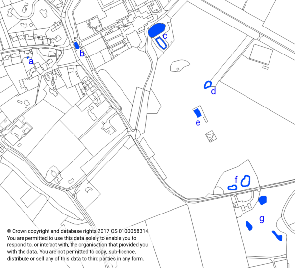
See list of ponds with map grid references on following page.
|
a |
TL179247 |
Pond behind Old Forge |
|
b |
TL180247 |
Village Green Pond |
|
c |
TL182248 |
Pond(s) adjacent to Temple Dinsley House |
|
d |
TL183246 |
Pond in PHC Field |
|
e |
TL183246 |
Pond or possibly old slurry pit |
|
f |
TL184244 |
Ponds or standing water Visible from School Lane – possibly seasonal. Not shown on OS Master Map data or 1:25000 Map |
|
g |
TL185244 TL184243 TL185243 |
3 Ponds in Ladygrove North (Kiln Wood) |
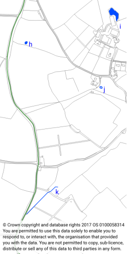
Ponds and Stream to West of
Village
|
h |
TL172251 |
Pond near Sootfield Green, in field between Dead Woman’s Lane and Charlton road |
|
i |
TL176252 |
Pond to north of buildings at Castle Farm |
|
j |
TL175249 |
Evidence of former pond at The Pond Farmhouse |
|
k |
TL173243 to TL172242 |
OS 1:25000 map shows a stream or watercourse Aerial imagery shows features that may once have been a watercourse – water has been seen flowing from the wood into the roadside gulley in living memory |
|
Preston Hill Farm Pond - TL179239
|
Source of the River Hiz - TL174275
|
3. St. Martin’s Churchyard TL178248
On this one acre of land, there is an avenue of Irish yews, planted soon after 1900 and recently coppiced, tall conifers with an understorey of brambles along the boundary fence, and, on the gravestones, many lichens. Hedgehogs, tawny owls, gold crests and green woodpeckers are recent recordings.
4. Green Lanes: 2
Dead Woman’s Lane and its northern extension, Tatmore Hills Lane, are ancient trackways with tall hedges and solid banks; they act today as vital corridors of shelter and food supply for many species. Bats, linnets, yellowhammers, and among the flora, ransoms, dog’s mercury, red bartsia, knapweed as well as bluebells have all been recorded.
5. A Former Park: 1
To the north of the 17th Century Offley Holes Farmhouse, lies an area of pasture with occasional trees, partly edged by metal railings. This is the legacy of a small landscape park of the 19th century, when there were over 200 parks throughout Hertfordshire. Hugh Prince charts its development, as follows:
|
Size in acres |
Owner |
Source |
|
50 |
Rev. Lynch Burroughs |
Bryant’s Map of Hertfordshire, 1821 |
|
40 |
Richard Marsh |
OS 1st edition, 6’’ map, 1863-1881 |
Cattle and sheep now regularly graze this pasture, a rare sight in the farming scenes in North Hertfordshire today. This grassland also provides a valuable food supply for small mammals, insects and grassland birds, amongst the arable acreage in the north of the parish.
6. Green Spaces
Public green spaces, such as The Green, the Recreation Ground and Church Meadow, and privately owned green spaces such as the churchyard, the ‘overgrown’ meadow off Back Lane and the NHDC field and the abundance of gardens across the village, not only contribute visually to the open spacious feel of the ‘village scape’, but now contribute generously to the food and shelter available to many wildlife species, especially birds, insects, amphibians and small mammals.
Green Spaces: 12 plus verges
The village benefits from the following green spaces, some of which are “Wastes of the Manor”.
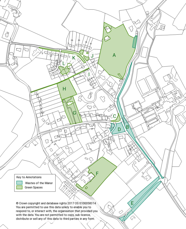
|
A |
Cricket and Recreation Ground – adjacent to Hitchin Road. One corner is also a Waste of the Manor |
|
|
B |
The verge running from opposite the Recreation Ground to the entrance of PHC and including the Village Green Pond |
Waste of the Manor |
|
C |
The grass verge between Preston House and the Village Green. |
|
|
D |
The Village Green, including the area with the Village Well and Telephone Box |
Waste of the Manor |
|
E |
The verges either side of the lane and the triangle in the fork of the lane along Crunnels Green |
Waste of the Manor |
|
F |
Preston Primary School Playing Fields |
|
|
G |
St. Martin’s Churchyard |
|
|
H |
The Millennium Play Ground – accessible via the Churchyard and Chiltern Way Extension Footpath |
|
|
I |
Chiltern Way Extension Footpath – At the Chequers Lane end and the Millennium Playground this is wide enough to be considered a green space as well as a path |
|
|
J |
The grass verges around the car park in Chequers Lane |
TL179249 |
|
K |
The grass verges in front of 15 to 25 Chequers Lane |
|
|
L |
The grass area enclosed by 1 to 6 Templars Lane |
In addition to these, many of the roadside verges throughout the village are green spaces that provide vantage points to view the countryside, refuge from traffic for pedestrians, as well as in some places a surface on which dogs and humans can walk. Some of the verges merge seamlessly into frontages and gardens. All of this forms a key part of the rural character of the lanes in the parish.
The footpaths, bridleways and green lanes are often wide enough to be considered as green spaces as well as Rights of Way.
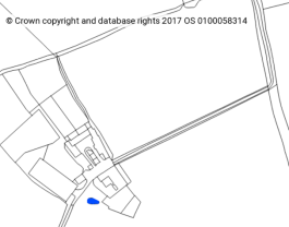
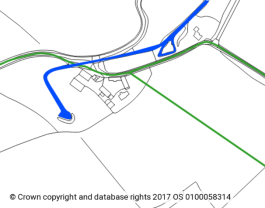
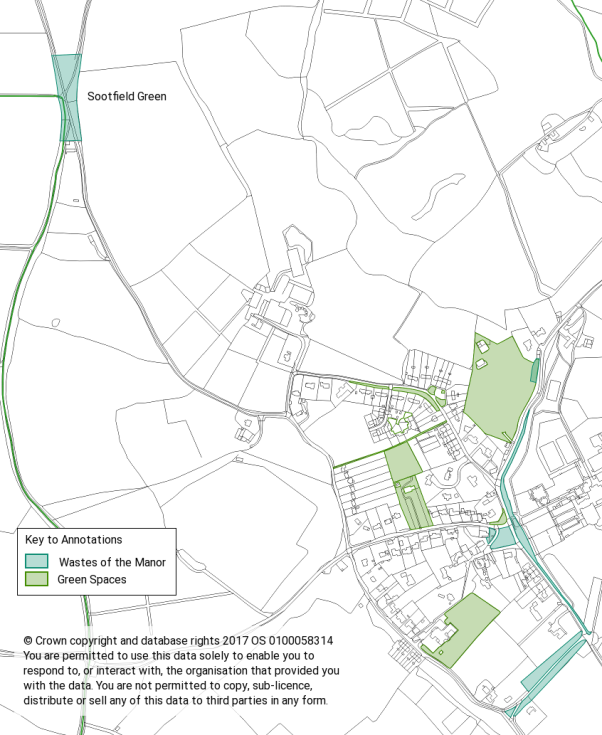
There is also a Waste of the Manor at Sootfield Green as shown below
Species Data for the Parish
The National Biodiversity Network Trust, a registered charity, organises nationally, the collation of biodiversity data and maintains the NBN Atlas. The Hertfordshire Environmental Records Centre at St. Albans collaborates with the NBNT. The NBN database records 13,375 entries for this parish; these entries are submitted by both professional and expert amateur ecologists, after fieldwork surveys in the parish.
The number of species (shown in brackets) of the flora and the fauna give us an insight into what is living in, and sharing, the environment of our parish:
|
Animals: |
Mammals (21) |
Birds (86) |
Amphibians (3) |
Reptiles (1) |
|
Insects: |
Beetles (7) |
Butterflies (21) |
Moths (22) |
True bugs (5) |
|
Plants: |
Conifers (4) |
Ferns (2) |
Flowering plants (329) |
Horsetail (1) |
|
Bryophytes & Algae: |
Lichens (34) |
Liverworts (2) |
Mosses (23) |
|
Total number of different species: 561, all having been seen and identified in this parish in recent decades. It is likely that this seemingly high figure is not the full total. Expertise and time are needed to notice and to identify all species, in every season, year by year; the availability of skilled ecologists/observers is essential for a fuller recording of all species.
Within the fauna, the parish has some species which are protected under both national and European legislation:
The NERC Act is the Natural Environment and Rural Communities Act of 2006.
- Amphibians: common frog, common toad and smooth newt: all are Species of Principal Importance, Section 41 NERC Act.
- Birds: willow tit, lesser spotted woodpecker, lesser redpoll: all are ‘Woodland Red Listed Birds’, and Species of Principal Importance, Section 41 NERC Act.
- Birds: grey partridge, spotted flycatcher, yellowhammer, corn bunting, linnet: all are ‘Grassland Birds of Conservation Concern Red listed species’, and Species of Principal Importance, Section 41 NERC Act.
- Birds: swift, short-eared owl, common redpoll: these are ‘Birds of Conservation Concern Amber listed species’.
- Lichens: The lichen, Flavoplaca dichroa, was recorded in the parish in 2012, and is ‘Nationally Scarce’.
- Reptiles: The slow worm, Anguis fragilis, has been recorded, and is a Species of Principal Importance, Section 41 NERC Act.
- Mammals: brown hare: this is a Species of Principal Importance, Section 41, NERC Act.
- Mammals: bats: 5 species have been recorded in the parish: all are European Protected Species, also Species of Principal Importance, Section 41 NERC Act. The 5 species are: common pipistrelle, brown long-eared, Myotis spp., the natterer, the daubenton.
Farming and the Environment
For centuries, farming has had a greater effect on the landscape and all habitats than any other human activity. Recent changes in farming practice have often degraded the landscape and many habitats. We need to ensure that the farms have the capacity to produce food and so sustain the nation’s human population. But, since the Department of the Environment’s ‘Countryside Survey’ in the 1980s, government legislation has, through the Set-Aside Schemes, required farmers to give greater consideration to the flora and the fauna of their local farmland.
In 2016, a new Countryside Stewardship Scheme, with Single Farm Payments offering capital grants towards supporting and enhancing environmental sustainability, has taken this policy a step further.
Within this small parish, there is a wide diversity of habitats. We need to ensure that these are maintained, restored and enriched. With detailed ecological data available, sites can be identified for habitat creation. The new Stewardship Scheme can assist with creating ‘wildlife corridors’ within and across the parish, linking one grassland with another, one woodland with another, along a network of botanically diverse hedgerows, verges and bridleways. Sufficient well maintained ponds are needed to enable many species to survive, breed and thrive. This concept of a 'Green Infrastructure' across the parish and the wider landscape, gives some priority to the basic needs of the wildlife.
Fauna and flora do not recognise parish boundaries. The habitats straddle across our parish boundaries, for example, woodland continues into St. Paul’s Walden Parish, and chalk downland continues along the Chiltern scarp slope into Offley Parish.
On a wider landscape scale, within a few miles of this parish, we have a scattering of medium and smaller size woods and spinneys, and a mosaic of historic landscaped parks. These include: Hitchin Priory Park, St. Ibbs Park, St. Paul’s Walden Bury, Kings Walden Park, Offley Place and Putteridge Bury as well as our own Temple Dinsley Park. Ecologically similar habitats can be identified, and wildlife networks created and maintained. Opportunities exist to restore and generously to enrich the local environment, for the benefit of all.
Listed Buildings
This is a National status, and applies to 63 buildings on 42 sites in this small parish. 61 are Grade II. Two are Grade II*, which are ‘particularly important buildings of more than special interest’.
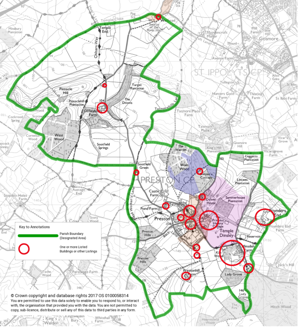
The map above and following detailed maps clearly show the present number and distribution of buildings and structures of national merit in the parish. The high number is evidence of the wealth of past residents, and of the availability of tradesmen and craftsmen to construct premises of such quality.
The Location of Listed Buildings in the Village
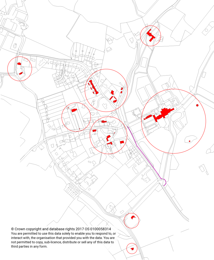
Note: the wall and gate piers shown in magenta are also listed.
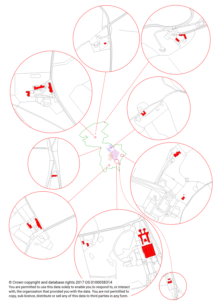
The location of Listed Buildings, beyond the Village
Index of Listed Buildings:
|
Name |
Listed Entry Number from Historic England |
|
|
Bunyan’s Cottage |
LEN 1347489 |
|
|
Chequers Cottages 1-6 and 3 linked rear outhouses |
LEN 1176623 |
|
|
Crunnells Green Cottage |
LEN 1102423 |
|
|
Fir (Fig) Tree Cottage |
LEN 1102426 |
|
|
Hitchwood Cottage 1-2 and outhouse |
LEN 1176749 |
|
|
Kiln Wood Cottage and linked outhouse |
LEN 1102433 |
|
|
Laburnam Lodge (Joyners Cottage as at April 2018) |
LEN 1347481 |
|
|
Ladygrove Stud Farm, Dairy Cottage, Kiln Wood Lodge, Ladygrove Lodge |
LEN 1176799 |
|
|
Offley Holes Barn and Cartshed |
LEN 1102429 |
|
|
Offley Holes Barns |
LEN 1176723 |
|
|
Offley Holes Farm House |
LEN 1307781 |
|
|
Offley Holes ‘The Lodge’ |
LEN 1347484 |
|
|
Poynders End House |
LEN 1102431 |
|
|
Poynders End: Tudor House |
LEN 1102430 GRADE II* |
|
|
Poynders End: Tudor House Octagonal Dairy |
LEN 1176732 |
|
|
Preston Hill Farm: West Barn |
LEN 1347485 |
|
|
Preston Hill Farm: East Barn |
LEN 1176739 |
|
|
Princess Helena College: Ice House |
LEN 1176789 |
|
|
Princess Helena College: House and Formal Gardens |
LEN 1307766 GRADE II* |
|
|
Princess Helena College: Gate Posts and Park Wall |
LEN 1102432 |
|
|
Princess Helena College: The Piggery |
LEN 1347448 |
|
|
Princess Helena College: The Dower House |
LEN 1102427 |
|
|
Princess Helena College: Temple Dinsley |
LEN 1000919 Parkland GRADE II* |
|
|
Red Lion Public House |
LEN 1102425 |
|
|
Reeves Cottage |
LEN 1102424 |
|
|
Rose Cottage |
LEN 1102460 |
|
|
Sadleirs End |
LEN 1347463 |
|
|
Sootfield Green |
LEN 1389610 |
|
|
Spindle Cottage Barn |
LEN 1102428 |
|
|
Spindle Cottage |
LEN 1176712 |
|
|
St. Martin’s Church: The Lychgate |
LEN 1102461 |
|
|
St. Martin’s Church (C. of E.) |
LEN 1176631 |
|
|
St. Martin’s Church: The Mausoleum |
LEN 1102420 |
|
|
St. Martin’s Place |
LEN 1102421 |
|
|
Telephone Kiosk |
LEN 1103249 |
|
|
The Old Forge |
LEN 1102422 |
|
|
The Well on The Green |
LEN 1176692 |
|
|
The Wilderness |
LEN 1307843 |
|
|
The Chequers, with Wall and Outhouse |
LEN 1307773 |
|
|
Vine Cottage |
LEN 1347482 |
|
|
Wellhead Farm: Granary and Barn |
LEN 1102459 |
|
|
Wellhead Farm: South-West Barn |
LEN 1307809 |
|
Undesignated Heritage Assets
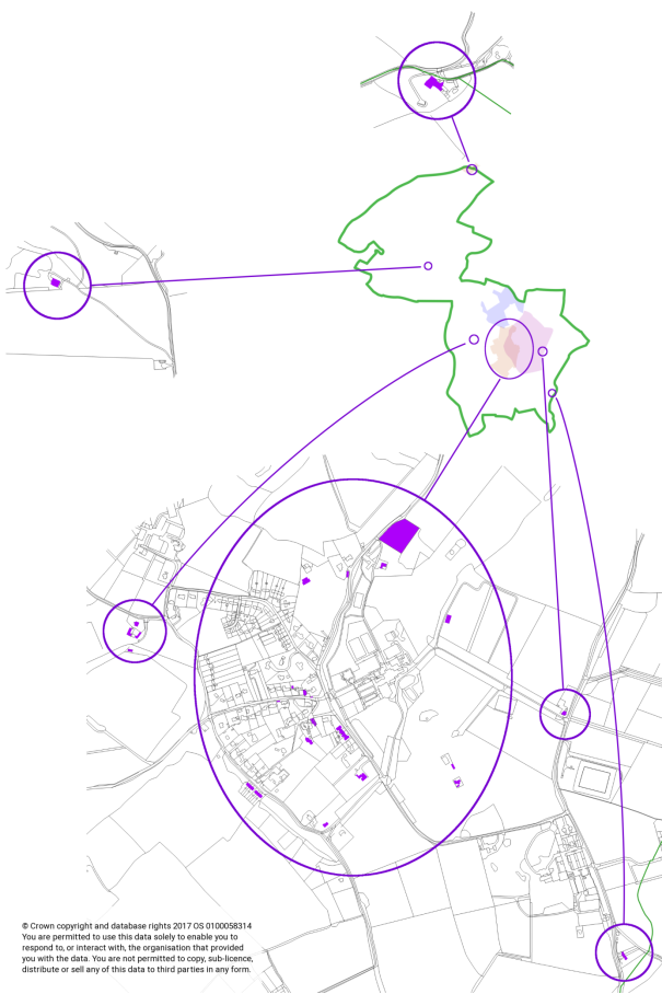
In addition to the listed buildings there are a number of undesignated buildings that have the potential to be considered as heritage assets. These are mostly located in and around the village. Areas containing the undesignated heritage assets are shown by the purple circles and oval below.
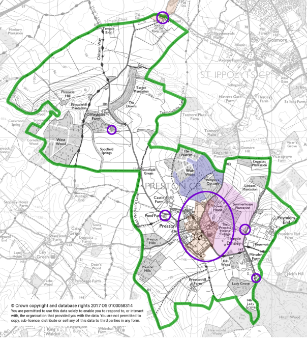
Investigating the assets and their heritage potential is a project to be undertaken outside of the Neighbourhood Plan if there are parties interested and the opportunity to do so.
Locations of Undesignated Heritage Assets
List of Undesignated Heritage Assets
|
TL175276 |
Wellhead Farm – Barns and farm buildings other than those already Grade II |
|
TL168260 |
Former Coach House of Offley Holes House |
|
TL175248 |
Open Sided Barn or Coach House at The Pond Farmhouse |
|
TL175249 |
The Pond Farmhouse and Barns / Outbuildings |
|
TL178245 |
Holly Cottages, Back Lane |
|
TL180244 |
3 Crunnells Green |
|
TL181245 |
Crunnells Green House |
|
TL187241 |
5 to 7 Hitchwood Lane (Hitchwood Cottages) |
|
TL183245 |
Barns or Agricultural Buildings in field with Permissive path in grounds of PHC |
|
TL183249 |
Barn or Agricultural Building in Summerhouse Plantation |
|
TL186247 |
1 and 2 Lodge, Temple Dinsley |
|
TL181250 |
Barn at the Dower House |
|
TL182251 |
Walled Garden (derelict) adjacent to Dower House and Preston Road |
|
TL180250 |
Barn (Conversion) beside road at the Hartings |
|
TL179250 |
Pavilion, Recreation Ground |
|
TL180247 |
Section of brick wall to garden of Preston House and Church Lane |
|
TL179247 |
John Bunyan Chapel - Now Redmayne Bentley Stock Brokers |
|
TL179247 |
Barn at St. Martin’s Place, Church Lane |
|
TL179247 |
Barn at The Old Forge, Church Lane |
|
TL180247 |
Outbuilding at The Red Lion |
|
TL180247 |
Kenward Cottage |
|
TL179246 |
Pryor House |
|
TL180246 |
Village Hall and The Bungalows, School Lane |
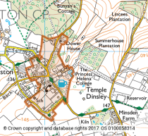
Temple Dinsley / Princess Helena College
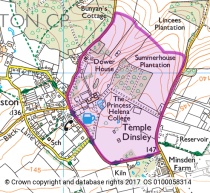
The garden and other land at Temple Dinsley are registered
under the Historic Buildings and Ancient Monuments Act
1953, within the Register of Historic Parks and Gardens by
English Heritage for its special historic interest (marked
in magenta/pink).
Temple Dinsley has an 18th century park, and an early 20th century garden, of national merit, both are on the English Heritage Register as Grade ll*.
It is not known exactly when the 18th century park was formed. An 18th century brick ice house still exists in the park, and it is listed. Hugh Prince in his book, ‘Parks in Hertfordshire since 1500’ charts the development of this landscape, as follows:|
Size in acres |
Owner |
Source |
|
65 |
Thomas Harwood |
Bryant’s Map of Hertfordshire, 1821 |
|
50 |
William H. Darton |
OS 1st edition, 6’’ map, 1863-1881 |
|
70 |
Countess of Carnarvon |
OS 5th edition, 1’’ map, 1932-33 |
The historic Landscape Park and Gardens are now registered as 200 hectares in size. Temple Farm homestead in the southern part of the park was demolished in the early years of the 20th Century. In c.1908 Edwin Lutyens was commissioned to design and have built ‘The Piggery’, a small brick building with pyramidal roof, as an ‘eyecatcher’ feature, clearly visible from the south drive and the house. The park is laid to pasture and woodland, with the Summerhouse Plantation created in the early 20th century; these, with two small ponds, form valuable habitats for wildlife, to the south east of the village settlement. The listed 18th century Dower House stands north of Temple Dinsley house, within the registered park. The two fine pairs of gate piers and flanking walls at the entrance to the south drive, also designed by Lutyens in c.1908, are listed, as is the park wall.
The Gardens and Pleasure Grounds were laid out by Lutyens, with planting designs by Gertrude Jekyll, c.1909-1910. No planting plans still exist. The hard landscaping of brick walls and terraces, the York stone steps and paths, the brick loggia and belvedere are all to be seen in situ today, and make clear the 8 main compartments or ‘rooms’ of the original plan: the Rose Garden, the 2nd Rose Garden, the Herbaceous Garden, the smaller Herbaceous Garden, the Diamond Garden, the Spring Garden, the Pool Garden and the Pergola Garden. Lutyens’s ornamental pool has become a swimming pool for the Princess Helena College students; this is much enjoyed by the residents of the parish and their families in the summer holidays. The Hertfordshire Gardens Trust assisted with some restoration of The Rose Garden in 1993, and the rose growers, Harkness of Hitchin, supplied new rose bushes, as the firm had done in 1909. Today, the planting throughout the gardens is much simplified from the exuberance of the Edwardian days, when labour was cheaper.
Preston Conservation Area
Much of the present village, the house and gardens of
Temple Dinsley lie within the Preston Conservation Area.
The central core of this historic village was awarded this designation on 8th June 1970. This area (marked in orange) includes houses of different ages, sizes and materials, with their gardens, The Green and the four lanes and the one footpath which all converge there, and, also, the house and formal gardens of Princess Helena College. There are 33 Listed Buildings within the designated Conservation Area.
Charlton Conservation Area
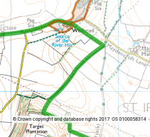
The area was designated on 12th September 1977.
The southernmost tip of this area falls inside the Parish
of Preston. The sloping fields surrounding the Wellhead
Farm spring source of the River Hiz, allow rainwater to
percolate through the soil and thus contribute to the
volume and flow in the spring. The valley shape is shallow,
the river channel narrow, and the flow of water now much
more irregular than it was 30 years ago, but, in an
otherwise somewhat dry landscape, this feature is of real
significance and deserves full protection.
Former Gardens of Merit
a.Offley Holes House: the house was designed by W.L. Lucas, and built in 1894. He may have also designed the garden.
b.Poynders End House: the house was designed by Geoffry Lucas of Hitchin, and built in 1905. It is not yet known who designed the garden.
Research on both sites is continuing. Neither site is registered by Historic England.
Areas of Archaeological Significance (AAS)
This is a County and District status, devised in the 1980s by NHDC Museum Service’s Field Archaeology Officer, Gilbert Burleigh, and the NHDC Planning Department.
List of ‘Monument Sites’ i.e. Earthworks and Landscape Features
|
HHER no. |
Description |
|
12597 |
Possible Saxon ‘sacred place’, Wain Wood |
|
9121 |
AAS 188: Possible site of ‘Welei’, a deserted medieval village, sherds of 11th/12thC. pottery and a medieval roof tile |
|
1956 |
AAS 99: Possible site of an early medieval ‘Preston Castle’. Also the site of a ‘fortified’ 18thC house, with literary associations: Lawrence Sterne’s ‘Tristram Shandy’ |
|
17252 |
Cropmark of pits, Sootfield Green |
|
18756 |
Cropmarks of several enclosures and a trackway, possibly a Romano-British farmstead, Sootfield Springs |
|
1721 |
Burial, unknown date |
|
17249 |
Cropmarks of enclosures, ditches and pits, possibly an extensive ‘farmed landscape’ of prehistoric date |
|
17250 |
As above |
|
17251 |
As above |
|
6577 |
Cropmark of a straight linear feature, aligned East-West |
|
4756 |
AAS 192 Possible terraced ‘house platforms’ from former cottages |
|
10834 |
Site of post-medieval kilns, with ponds in the former clay pits |
|
4600 |
Part of a ‘supposed Roman road’ from Verulamium to Ickleford, and beyond; not proven |
|
4604 |
As above |
|
Temple Dinsley: 10 Monument sites, and 1 Landscape site |
|
|
2883 |
AA 168 Site of the Preceptory of the Knights
Templar and of the Knights Hospitaller, |
|
11933 |
Supposed site of the 16thC manor house at Temple Dinsley |
|
1835 |
Possible deserted medieval settlement, and an undated ‘holloway’, or sunken lane |
|
18228 |
Substantial post medieval field boundary ditch, and other linear earthworks and possible enclosures |
|
18229 |
Post medieval trackway: the access route to the former Temple Farmhouse, its barns and yards |
|
18231 |
Group of post medieval clay extraction pits, presumably connected with the kilns in Kiln Wood |
|
13053 |
Site of Temple Farm, a post medieval farmstead, demolished c. 1910 |
|
18230 |
Post medieval sub-rectangular pond, within the curtilage of the former Temple Farm |
|
18226 |
Site of early 20thC sewage tanks, Temple Dinsley: the 2 small rectangular structures were replaced by a circular structure by 1924, and this was not in use by 1981 |
|
18227 |
Site of an extraction pit or quarry, Summerhouse Plantation, Temple Dinsley |
|
7341 |
A ‘LANDSCAPE’ site: the 18thC Park and the 20thC Gardens of Temple Dinsley; upgraded to Grade 2* in July 2002 |
|
AAS sites for which we do not have HHER reference numbers |
|
|
AAS 146 South of Charlton – A cropmark of an enclosure of unknown date and function |
|
|
AAS 202 Sootfield Green – Evidence for a medieval and post medieval settlement |
|
|
AAS 238 Wellhead – Evidence for a Roman and medieval settlement |
|
|
AAS 239 South of Temple Close – Strip lynchets, visible on aerial photographs |
|
HHER = Hertfordshire Historic Environment Record number
AAS = Area of Archaeological Significance – a designation
devised in the 1980s by the NHDC Museum Service and the
Planning Department.
List of Archaeological Artefacts or Objects Found in the Parish
In the last 200 years, and now stored in 4 locations: the NHDC North Hertfordshire Museum in Hitchin, St. Martin’s Church in Preston, St. Mary’s Church in Hitchin, and The British Museum in London.
1.The NHDC North Hertfordshire Museum, Brand Street, Hitchin:
|
HHER no. |
Description |
|
|
555 |
Palaeolithic flint implement |
|
|
1722 |
Flint implements |
|
|
1429 |
Roman coins, and a 5’’ high biscuit coloured ‘urn’ |
|
|
1428 |
Sherds from 4 Romano-British pottery vessels, 1st – 2nd C. AD |
|
|
1481 |
Roman brooch, c.200 AD |
|
|
4009 |
Medieval brown earthenware ‘bowl on a foot’: a chafing dish |
|
|
LM Acc.no. |
||
|
LM 2055 |
Pottery sherds, from Romano-British to the 19th C. |
Not donated. |
|
LM 2054 |
Possible head of a shepherd’s crook |
Not donated. |
|
LM 2556 |
Medieval copper alloy ‘strap-end’, for a belt |
Not donated. |
|
LM 804 |
12 medieval glazed floor tiles from Temple Dinsley |
HHER = Hertfordshire Historic Environment Record number
LM/HM Acc. No. =Letchworth Museum /Hitchin Museum Accession number, now combined in the collection at the North Hertfordshire Museum, Hitchin
2. St. Martin’s Church, Preston:
Part of the lid of a medieval stone coffin, in Purbeck marble, decorated with a floriated cross on its upper side and a simple cross on its underside. Probably from a ‘tomb-chest’ grave of a Master of the Knights Templar Preceptory at Temple Dinsley. This very significant artefact is now on display in the church; it has been erected on an oak frame, in memory of Christopher Sansom, a local resident and historian.
3.St. Mary’s Church, Hitchin:
Three medieval defaced limestone effigies, with one, possibly, of a Templar knight, all now recumbent on a windowsill in the north aisle of St. Mary’s Church. Nathaniel Salmon, writing in 1728, records that ‘….three several Figures lying, cut in a coarse stone, are said to be brought down from Temple Dinsley when that Chapel was pulled down….’ Sir Benedict Ithell had purchased the Temple Dinsley estate in 1714; he had pulled down the earlier house and built the present mansion. During the building works, his builders may well have disturbed the graveyard of the Templars and Hospitallers, and found the effigies. It would have been respectful and appropriate, at that time, for Sir Benedict to have given them to the nearest church for safe keeping. Sir Benedict was a subscriber to Nathaniel Salmon’s new volume of 1728. Bridget Cherry, writing in 1977, records the ‘three defaced stone effigies, one from the mid 13thC and two from the late 14thC’, but she does not confirm that one is that of a Knight Templar.
4.The British Museum, London:
a.Fragmentary chalice and paten, from Temple Dinsley
b.Five medieval glazed floor tiles, from Temple Dinsley
D. Conserving and Enhancing the Natural Environment
The following information and Policies have been provided to the Preston Parish Neighbourhood Plan Steering Group and Preston Parish Council by Herts and Middlesex Wildlife Trust. The Preston Parish Council (PPC) confirms their agreement to, and support of, the following Policies for Biodiversity.
D.1 The Parish of Preston supports a rich variety of natural habitats and species. Many of these are of regional and national significance. The PPC expects that the planning system should contribute to the conservation and enhancement of these and to the ecological systems that support them. In accordance with the NPPF, development policies will seek to maximise the benefits of planning decisions to biodiversity, within the context of sustainable development.
D.2 In order to accurately determine whether no net loss and enhancement to biodiversity can be delivered by development the PPC expects that, when requested, precise ecological assessment by suitably qualified people to accepted national standards be undertaken, sufficient to determine net gain.
D.3 The DEFRA Biodiversity Impact Calculator[1] has been designed to determine and quantify existing biodiversity value, in terms of habitats, and the consequent measures required to ensure no net loss and where possible net gain. This is considered the most appropriate mechanism for determining current ecological value and delivering net ecological gain.
Policy HERC1:When determining development proposals the PPC will ensure that decisions will minimise impacts and result in net gains to biodiversity. Net ecological impact will be determined by applying the DEFRA Biodiversity Impact Calculator and/or any revised methodology approved by DEFRA or any relevant successor authority. Only net positive ecological unit scores will be permitted. Ecological compensation may be delivered on or off site,
D.1 Determining Planning Applications Affecting Sites of SignificantBiodiversityInterest
D.4 When determining planning applications where there is a requirement to conserve and enhance biodiversity the following principles will be applied.
D.5 If significant harm resulting from a development cannot be avoided (by locating on an alternative site with less harmful impacts), adequately mitigated, or, as a last resort, compensated for, then planning permission will be refused.
D.6 Planning permission will be refused for development resulting in the loss or deterioration of irreplaceable habitats such as; ancient woodland, traditional orchards, aged, veteran, champion trees, or trees of a high conservation value located outside ancient woodland, unless the need for and benefits of the development in that location clearly outweigh the loss. In this instance substantial compensation consistent with the DEFRA Biodiversity Impact Calculator will be expected.
Policy HERC2: In considering development resulting in significant ecological impact there will be a presumption against such development unless clear and significant ecological gains can be demonstrated using the Biodiversity Impact Calculator.
D.2 Sites of Acknowledged Nature Conservation Value
D.7 Local Wildlife Sites (LWS) are non-statutory designated sites that occur within Preston. There are also many non-designated sites that conform to the definition of Priority Habitat, as defined by the Natural Environment and Rural Communities Act (NERC) 2006. These are of varying degree of importance for nature conservation and receive varying degrees of protection.
D.8 The Herts Environmental Records Centre hold records of all known sites of nature conservation value in Hertfordshire.
D.9 There are also many known sites of critical importance to species of national and international importance, such as bat roosts. Records of these are held by HERC and/or specialist recording groups.
D.10 The Preston Parish Council (PPC) will consider applications for development affecting any of these sites against criteria commensurate with their relative ecological status and protection within a local, national and international status. Their local context is particularly important. Therefore a particular habitat or species may be nationally frequent but extremely rare locally or nationally scarce and locally frequent. Examples of this include water vole, otter or barbastelle bat. Development affecting any of these sites or species is expected to result in a net gain to their area or populations.
Policy HERC3: In determining development
proposals affecting designated sites and Priority Habitats
or Species, the PPC will ensure that their nature
conservation value is protected in accordance with their
status. Development affecting such sites is expected to
deliver a net gain
in biodiversity. In granting permission North
Herts District Council will impose conditions or seek
planning obligations that secure appropriate management
regimes to deliver biodiversity gain in‑perpetuity.
D.3 Networks of Biodiversity and Green Infrastructure
D.11 The protection and enhancement of biodiversity assets is dependent on robust networks of Green Infrastructure (GI) which facilitate movement and genetic exchange.
D.12 GI is expected to positively contribute to the conservation, restoration, re-creation and enhancement of networks of biodiversity on a landscape scale. The size and location of GI is expected to be suitable for the function it is intended to fulfil. Where required, GI should ensure permeability for wildlife through development and provide sufficient beneficial habitat to support target species, independent of its connective function.
D.13 Monitoring of GI and habitat creation to ensure that it develops in accordance with its stated intention will be expected. If it is not achieving satisfactory condition within stipulated timeframes, remedial measures will be required. Mechanisms to achieve this must be outlined in development proposals.
D.14 Buffering of watercourses is important to protect the aquatic environment from pollution and disturbance, and to create movement and habitat corridors for wildlife. Development will not be permitted within 8m of a watercourse.
D.15 Many species are entirely dependent on human habitation for their reproductive success. Modern housing standards virtually eliminate opportunities for these species. Consequently where appropriate, features for biodiversity within development will be expected. Simple inexpensive measures can result in significant gains such as, integrated bat roost cavities, integrated swift or house martin boxes. These measures, if required, are expected to be permanent in order to deliver meaningful ecological gain. Therefore these features will be expected to be built in to suitable structures rather than provided as vulnerable, isolated and temporary boxes.
D.16 Bat populations are particularly sensitive to development that severs or disturbs movement corridors. Where appropriate, flight corridors should be identified and protected or enhanced to ensure the ecological functionality of bat populations. Examples of suitable measures include green bridges, underpasses or tunnels that are situated on the exact traditional routes of bat populations and free from disturbance.
Policy HERC4: In considering development proposals the PPC will expect Green Infrastructure to provide permeability for wildlife through and around development. GI should be connective and functional as wildlife habitat in its own right not just as a link between habitats.
Policy HERC5: All suitable development will be expected to include integrated bat and bird roosting devices within the fabric of the brickwork.
Policy HERC6: In considering development proposals that negatively impact upon bat movement corridors the PPC expects that these corridors are identified, protected and enhanced to ensure continued ecological functionality of bat populations.
Policy HERC7: Development will not be permitted within 8m of a watercourse.
D.4 Ecological Survey Standards
D.17 The provision of quality ecological information is critical in determining the impacts of development and securing meaningful ecological gains. Survey and mitigation measures must therefore conform to the following principles:
D.18 Ecological information must be provided by suitably qualified personnel. Details of qualifications and experience must be provided with all ecological reports.
D.19 Ecological surveys must answer the following questions; what features are present, what is the ecological value of these features, how will these features be affected by the development proposals, how can these impacts be avoided, mitigated or compensated so that there is a net gain to biodiversity.
D.20 Survey methodology and reporting must conform with nationally accepted standards. All surveys and reporting must be conducted in accordance with British Standard 42020: Biodiversity – Code of practice for planning and development.
D.21 In certain circumstances divergence from these standards may be acceptable but this must be agreed with appropriate officers at North Herts District Council before commencement. Unauthorised deviation from these survey standards will not be accepted and may be reported to The Chartered Institute of Ecology and Environmental Management - CIEEM.
D.22 Appropriate environmental records searches are expected in support of planning applications. When submitting ecological information the PPC expects that records searches, consistent with the rules of the professional body governing ecological consultants (CIEEM), are supplied to enable adequate ecological assessment.
D.23 Where European Protected Species (EPS) mitigation licences are required, answers to the 3 tests of the licence must be supplied for consideration by the PPC. Failure to do so will result in applications being refused as the PPC will be unable to meet its obligations under the Conservation of Habitats and Species Regulations 2010.
Policy HERC8: In considering ecological information in support of planning applications the PPC expects that surveys are undertaken by suitably qualified personnel and are consistent with nationally accepted standards i.e. British Standard 42020: Biodiversity – Code of practice for planning and development.
D.24 Lighting within and around development is expected to respect the ecological functionality of movement corridors. Certain species of invertebrate and mammal are highly sensitive to inappropriate lighting. In these circumstances surveys are expected to determine where these movement corridors are and measures put forward that demonstrate how these will be protected and enhanced.
Policy HERC9: In considering development involving potentially adverse lighting impacts to wildlife the PPC will expect surveys to identify movement corridors and ensure that these corridors are protected and enhanced.
D.25 Landscaping design can have a significant beneficial effect on wildlife. Landscaping schemes will be expected to maximise opportunities for wildlife. The PPC expects the selection of ecologically appropriate species in such schemes, of local provenance where possible.
D.26 Tree planting schemes where the primary purpose is to provide ecological enhancement should look to maximise diversity of species. Species selected should be suitable to the soil conditions and be comprised of appropriate vegetation communities consistent with National Vegetation Classification communities (NVC).
D.27 Naturalistic tree planting should not be in straight lines.
D.28 The establishment and management regimes of naturalistic planting schemes are critical to their success. These must be stipulated in development proposals together with mechanisms to monitor and address any deficiencies in the fulfilment of their stated objective.
Policy HERC10: In considering landscaping
schemes the PPC will expect that appropriate native species
are used whenever possible and that benefits to
biodiversity are maximised.
E. Reference Books and Maps Consulted
for Sections 3 and 10 of the Neighbourhood Plan
|
Books and written reference material: |
|
|
1. |
The Historical Antiquities of Hertfordshire by Sir Henry Chauncy, 1st edition London 1700, 2nd edition Bishop’s Stortford 1826, facsimile edition Dorking 1975. |
|
2. |
The History of Hertfordshire by Nathaniel Salmon, London 1728. |
|
3. |
An Inventory of the Historical Monuments in Hertfordshire, published by the Royal Commission on Historical Monuments (England), 1909. |
|
4. |
The Natural History of the Hitchin Region, edited by R.L. Hine and 7 contributors, published by the Hitchin and District Regional Survey Association, 1934. |
|
5. |
The place names of Hertfordshire, by J.E.B. Gover, A. Mawer and F.M. Stenton, Cambridge University Press, 1938. |
|
6. |
The Preston and Langley Village Scrapbook, created by members of The Preston and Langley Women’s Institute, 1953. |
|
7. |
Flora of Hertfordshire, by John G. Dony, published by Hitchin Urban District Council, 1967. |
|
8. |
Hertfordshire, in the Buildings of England series, by Bridget Cherry, Penguin Books 1977. |
|
9. |
The Hertfordshire Landscape, by Lionel M. Munby, Hodder and Stoughton, 1977. |
|
10. |
A Survey of the Ancient Woodlands of Hertfordshire, by Dr. Nigel Agar, Hertfordshire and Middlesex Wildlife Trust. (no date given). |
|
11. |
Gardens of a Golden Afternoon: The story of a partnership: Edwin Lutyens and Gertrude Jekyll, by Jane Brown, Penguin Books, 1985. |
|
12. |
The Wild Flower Habitats of Hertfordshire: Past, Present and Future, by Brian Sawford, Castlemead Publications, 1990. |
|
13. |
English Houses, 1200-1800: The Hertfordshire Evidence, by J.T. Smith, Royal Commission on Historical Monuments of England, 1992. |
|
14. |
The Chilterns, by Leslie W. Hepple and Alison M. Doggett, Phillimore 2001. |
|
15. |
Trees and Woodland in the British Landscape: The complete history of Trees, Woods and Hedgerows, by Dr. Oliver Rackham, Phoenix 2001. |
|
16. |
The Knights Templar in Britain, by Dr. Evelyn Lord, Pearson Education Ltd., 2002. |
|
17. |
A Report on Temple Dinsley, its park and gardens, by Dr. Diana Kingham, Hertfordshire Gardens Trust, 2004. |
|
18. |
Parks in Hertfordshire since 1500, by Dr. Hugh Prince, University of Hertfordshire, 2008. |
|
19. |
Flora of Hertfordshire, by Trevor James, Hertfordshire Natural History Society, 2009. |
|
20. |
A History of Preston in Hertfordshire, by Philip J. Wray, Berforts Information Press, 2015. |
|
21. |
St. Martin’s Church, Preston in Hertfordshire, by Philip J. Wray, privately printed, 2015. |
|
22. |
Butterflies of Hertfordshire and Middlesex, by Andrew Wood, Hertfordshire Natural History Society, 2016. |
|
Maps: |
|
|
23. |
Maps were produced with the volumes by H. Chauncy, and N. Salmon, as above. |
|
24. |
Dury and Andrews’ Map of Hertfordshire: Society and Landscape in the 18thC., by A. Macnair, A.Rowe and T. Williamson, Oxbow Books 2016. Included with this book, is a digitised version of the original 1766 map, on a DVD. |
|
25 |
‘The County of Hertfordshire from an actual survey’, by Arthur Bryant, scale 1 ½’’ to 1 mile, 1821, facsimile published by the Hertfordshire Record Society, 2003. |
|
26 |
‘Past and Present Map’ series: Letchworth, Stevenage, Hitchin and Baldock, including Great Offley, Pirton, Preston, Old Knebworth, Walkern and Weston. 4 maps at 1 : 50,000 scale from Ordnance Survey maps of 1834, 1896, 1919/1920, and 1974/2006, published by Cassini Publishing Ltd., 2006. |
F. Preston Parish Implementation Plan
F.1 The Preston Parish Neighbourhood Plan will be delivered over a period of 13 years (2018 – 2031) by adopting a partnership approach between the Preston Parish Council (PPC), North Hertfordshire District Council (NHDC), developers and the residents of Preston. It is only by harnessing the strengths of these groups that the Objectives of the Plan will become a reality.
F.2 The Neighbourhood Plan provides a direction for change through its vision, objectives and policies, while at the same time protecting the environmental and historic aspects of the parish which are highly valued and appreciated by the community. It is flexible to allow for new challenges and opportunities which may arise over the Plan period.
F.3 Any development that takes place during this time will need to take account of the Neighbourhood Plan policies. It is important to ensure this is monitored and that community projects identified through the neighbourhood planning process are achieved.
F.4 The Neighbourhood Plan sets out policies that have been developed from the priorities identified through community consultation. They include Quality of Life, Amenities and Facilities, Housing and Development, Environment and Heritage and Transport and Communication.
F.5 The Plan’s Housing and Development Policies have been developed to ensure that housing growth takes place in a managed and appropriate manner, which is directly linked to the needs of the community. The Parish Council will work in partnership with NHDC to achieve successful implementation of the Plan’s housing policies.
F.6 The next layer of growth in the parish must create a development of quality, contributing to the character of the village and providing local benefit. It must be more than an exercise in meeting housing supply ‘numbers’ by theaddition of characterless properties. The objective, therefore, is to enable the provision of a choice of new homes to meet the needs of all sections of the community in a manner which respects the character of the village and wider parish.
F.7 The Parish Council will scrutinise and advise on the appropriateness of planning applications for compliance with the Plan’s policies.
F.8 Preston Parish Council will lead on and monitor the implementation of the Neighbourhood Plan with a full review every five years to ensure that the policies remain in line with the North Hertfordshire Local Plan and any changes to national legislation.
F.9 The following table illustrates the actions required and by whom to realise the objectives of the Preston Parish Neighbourhood Plan. It will be reviewed on a regular basis as and when objectives are achieved or are changed through future community consultation.
|
Implementation Plan |
||||
|
Category |
Policy |
Action |
Timescale |
Responsibility |
|
Community Rights |
Paragraphs A-C inclusive |
Monitor and if felt necessary implement one or more of these Community Rights in support of other policies in the Neighbourhood Plan. |
Ongoing 2018-2031 |
Preston PC |
|
Quality of Life |
Policy QL1 Policy QL2 Policy QL3 |
Support the provision of opportunities for social interaction. To promote a community quality of life. Promote community identity by preserving heritage and historic features. |
Ongoing 2018-2031 Ongoing 2018-2031 Ongoing 2018-2031 |
Preston PC Preston PC NHDC and Preston PC |
|
Amenities and Facilities |
Policy AL1 |
Support proposals for new or improved community facilities which fulfil the needs of existing and new residents. |
Ongoing 2018-2031 |
NHDC and Preston PC |
|
Policy AL2 |
Sustain and support the development of facilities for the parish. |
Ongoing 2018-2031 |
NHDC and Preston PC |
|
|
Policy AL3 |
Support developments that encourage and sustain economic growth and creation of jobs. |
Ongoing 2018-2031 |
NHDC and Preston PC |
|
|
Housing and Development |
All Housing and Development policies Numbered HD1-HD11 inclusive |
1. Monitor all planning applications against all Housing and Development Policies. Engage with any pre-applications and consultations. 2. The overarching aims of the Housing & Development Policies are to deliver a housing growth strategy tailored to the needs and context of Preston. 3. Ensure that historic and heritage aspects are enhanced and maintained as it is these key factors which contribute to the distinctiveness of the parish. 4. Ensure proposals provide flood risk assessment and that suitable & sufficient foul sewage disposal provisions are made before any property is occupied and that no existing problems are exacerbated. The Parish Council to liaise with Anglian Water and Thames Water, if deemed appropriate, to support this policy. 5. Ensure that developers comply with the Considerate Constructors Scheme. 6. Provide support for measures of water conservation and landscape schemes that improve biodiversity and also plans for low carbon footprints. 7. Maintain a watching brief to assist the achievement of the aims of ‘Building Futures’ wherever possible. |
Ongoing 2018-2031 |
NHDC and Preston PC |
|
Environment and Heritage |
All Environment and Heritage policies numbered EH1-EH11 inclusive |
1. Monitor planning applications against the Environment & Heritage Policies. |
Ongoing 2018-2031 |
1. NHDC and PrestonPC |
|
2. Support developments that respect, protect and preserve the local landscape and rural character of the parish. |
Ongoing 2018-2031 |
2. NHDC and PrestonPC |
||
|
3. Ensure all development is environmentally sustainable and supports the principles of sustainability. |
Ongoing 2018-2031 |
3. NHDC and PrestonPC |
||
|
Transport and Communication |
Policy TC1 Policy TC2 |
1. To support and encourage safe use of roads, paths and bridleways for all users. |
Ongoing 2018-2031 |
1. NHDC and PrestonPC |
|
2. To support the development of efficient and effective broadband speed and mobile coverage. |
Ongoing 2018-2031 |
2. Preston PC |
||
|
3. The Parish Council will continue to liaise with the Police and Hertfordshire Highways on an ongoing basis with regard to the speed of traffic on village lanes. |
Ongoing 2018-2031 |
3. Preston PC |
||
|
4. The Parish Council will liaise with BT, BT Open Reach and mobile phone providers with regard to broadband speed and mobile phone coverage. |
Ongoing 2018-2031 |
4. Preston PC |
||
G. Preston Parish Project List
G.1 Other points and ideas raised through the Neighbourhood Plan Survey and during the Regulation 14 Consultation have been incorporated into a Project List. These ideas fall outside of the remit of the Neighbourhood Plan but may be taken forward by interested parties and some may be guided by the Parish Council.
|
Project List |
|||
|
Category |
Action |
Timescale |
Responsibility |
|
HGV Ban |
The Parish Council last investigated this in November 2015. They were told that Preston wasn’t covered by the Hitchin Urban Transport Plan under which weight limits are covered. The Clerk was informed that it would be difficult to justify the implementation of a weight restriction in Preston because the majority of the HGVs have genuine business and would not be prosecuted under a weight limit prohibition. During the previous 12 years the police had not received any HGV related complaints at Preston. Preston Parish Council to review this every 5 years and decide whether it is appropriate to further investigate this issue. Next review: 2020 |
Every 5 years |
Preston Parish Council |
|
New Conservation Area |
Investigation into the possibility of an additional Conservation Area to be designated to include all the Listed Buildings near Ladygrove Farm, including woodlands. The current Conservation Area was studied prior to its establishment in 1980. These studies were conducted to evaluate and describe:
|
Timescale identified by group taking on project |
Interested groups, possibly Preston Trust, should contact Preston Parish Council with their plan. The Parish Council to decide who best to carry out the investigation. |
|
Conservation Area Appraisal |
The production of a Conservation Area Appraisal document which sets out what it is in the Conservation Area which should be preserved or enhanced to maintain the character and appearance of the area. Work previously completed may be used as a starting point into thisinvestigation. |
By 2020 |
Preston Parish Council in conjunction with the NHDC Conservation Officer. |
|
Planning Guidance |
Consideration to be given to a Supplementary Planning Guidance to cover two specific areas:
Such guidance would encourage a high standard of design appropriate to the character of Preston. There may be an overlap with the Conservation Area Appraisal that presents opportunities to re-use or share work. |
Timescale identified by group taking on project |
Interested groups, possibly Preston Trust, should contact Preston Parish Council with their plan. The Parish Council to decide who best to carry out this guidance. |
|
Identify projects to improve infrastructure Section 106 |
Identify projects for infrastructure improvements throughout the parish that could be achieved as a result of Section 106 monies resulting from developments, ensuring that they meet the criteria agreed between NHDC, the developer and the Parish Council |
Ongoing |
Preston Parish Council in conjunction with NHDC |
|
Community projects Section 106 |
Identify projects that could be proposed to improve facilities that would serve and benefit the community using Section 106 monies, ensuring that they meet the criteria agreed between NHDC, the developer and the Parish Council. |
Ongoing |
Preston Parish Council in conjunction with NHDC. |
|
Community Projects General |
Investigate general projects (future and identified in the Neighbourhood Plan consultations) that could improve facilities to serve and benefit the community- see village shop and village hall below. |
As opportunity arises |
Preston Parish Council and/or interested groups who wish to pursue initiatives |
|
Village Shop |
Many residents have highlighted the need for a village shop. Any individual or group wishing to provide one should develop a business plan to ensure that it is a viable project. |
As the need arises |
Interested groups who wish to pursue this initiative. |
|
Village Hall |
Many residents have highlighted the need for a new, larger village hall. Any individual or group wishing to investigate the feasibility of this should contact the Parish Council with a detailed business plan. The Parish Council are custodians of the Village Hall which is owned by the Seebohm Trust, a registered charity which ensures that the Village Hall is maintained for use by the residents of Preston. |
At an appropriate time for the interested groups. |
Interested groups who wish to investigate this should present a viable business plan to the Parish Council. |
|
Undesignated Heritage Assets |
A list of Undesignated Heritage Assets is in Appendix C.3, page 79. There is an opportunity for an interested group of residents to compile the details with photographs of these assets for future reference. |
At an appropriate time for the interested groups. |
Interested groups who wish to pursue this initiative. |