Baldock, Bygrave & Clothall Neighbourhood Plan - Submission Version
Policy G1 Improving access and parking
Proposals for the following access and parking improvements will be supported (where planning permission is required):
- the provision of a limited amount of additional parking to serve Baldock railway station on a suitable site within the existing built-up area of the town, or as part of site BA1 proposed in the new North Hertfordshire Local Plan, if justified by the scale of development proposed in the Local Plan once it is adopted;
- improved pedestrian and cycle access to Baldock station, including the provision of lifts to both platforms and additional secure cycle storage as Baldock grows;
- changes to the drop-off and pick-up arrangements serving Knights Templar School to improve safety, especially if the school requires enlargement as a direct result of the allocations for housing in the new Local Plan (in which case appropriate contributions towards the improvements will be sought); and
- improved pedestrian and cycle access from Baldock High Street to the Tesco superstore.
Reason for this policy
There are several places in Baldock where better access and parking arrangements to serve existing facilities are needed now, or are likely to be needed within the period of this plan. There are also significant transport issues associated with the proposed developments on the edge of Baldock, which are addressed in policies E1 and E5 later in this plan. Some of the actions needed to tackle traffic, parking and access issues are outside the scope of the planning system, although the specific improvements noted in this policy are likely to need planning permission.
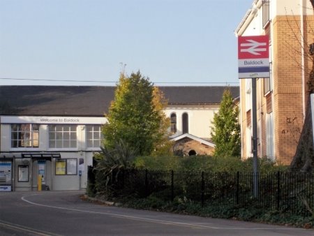
The expected growth of the town will lead to more use of Baldock railway station, whose existing car park has limited capacity. Commuter parking elsewhere in Baldock has become a growing problem, and while daytime parking restrictions have helped to manage this, Baldock's expansion is likely to generate additional demand to park at or near the station[3]. Responses to the Neighbourhood Plan survey showed 72% in favour of providing more parking for the station.
The scale of any additional parking would need to reflect wider policies to encourage walking, cycling and public transport use. A limited increase in provision would reduce the risk of additional parking attracting commuter traffic from well beyond the town and its nearby villages, and help encourage the use of non-car options to get to the station, while at the same time giving more scope to park for those that have to drive. To ensure that available parking is used most effectively, and avoid further parking pressures on residential roads, complementary (non-planning) measures may need to be considered, such as further parking restrictions and reviewing the eligibility for and price of car park season tickets.
It is important that any site for extra parking does not result in additional incursion into the countryside, or further loss of Green Belt beyond that already proposed in the new North Hertfordshire Local Plan. Two potential opportunities have been identified during the work to prepare this plan, both of which could be connected to the station subject to access being agreed. One is using a small part of the south-west corner of site BA1 (immediately to the north of the railway line), if this is allocated for development in the new North Hertfordshire Local Plan. The other is using part of the existing employment area on Royston Road, which is identified as employment area 'BE2' in the new Local Plan.
Any planning applications for parking on these sites would need to consider their suitability in terms of highway access and any impacts on residents living in the vicinity. Using part of BE2 would be a departure from the new Local Plan policy ETC1, which seeks to maintain business uses on this land[4]. Although only a small amount of BE2 would be required, any planning application for parking on part of BE2 would need to consider the impact on employment land availability at the time it is made.
Other improvements are needed to Baldock station, to encourage sustainable travel and allow access for all, in particular for those with limited mobility[5]. There is an opportunity to seek appropriate contributions to such improvements from developments that will place additional demands on the station.
Knights Templar School is likely to require further expansion to cater for the early phases of the town's growth, before a new secondary school could be provided as part of site BA1. Appropriate contributions to these will also have to be sought, and one particular need which has been identified is improvements to the current drop-off and pick-up facilities, to help limit vehicle movements outside the student entrance and improve safety.
Previous work on barriers to movement within Baldock has also highlighted the lack of direct and convenient access from the High Street to the Tesco superstore, which is the biggest retail outlet in the town[6]. Policy G1 encourages suitable opportunities to improve the quality and convenience of pedestrian and cycle access to the store to be taken forward.
Policy G2 Strategic green space
To conserve an important 'green lung' at the heart of Baldock, applications for development should maintain the predominantly open character of the land lying between Hartsfield School and the A505 Baldock Bypass[7], together with views from this area out to the countryside to the east of the town.
Proposals that would improve the visual or recreational value of this land will be supported, particularly if they form part of a comprehensive strategy for improved public access and the conservation and interpretation of the scheduled area. Any such proposals should be informed by community engagement; while any proposals affecting Walls Field and its setting should also conserve, and where possible enhance, its value as a scheduled monument.
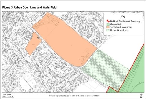
Walls Field – a historic 'green lung' at the heart of Baldock
Reason for this policy
Baldock contains a variety of open spaces that serve different functions, such as parks and play areas, school playing fields and cemeteries. The area described in this policy plays a particularly important role in maintaining a sense of openness within and at the edge of the town, the significance of which will grow once proposals for development in the new Local Plan are implemented. It also embraces a key part of Baldock's history, as the Walls Field scheduled monument marks the location of the Romano-British small town and Late Iron Age settlement that once existed here.
The North Hertfordshire Green Infrastructure Plan[8] identifies the value of Walls Field as part of this 'green lung', and the opportunities that exist for enhancing its historic and recreational value. At present, public access is limited to a footpath crossing the site. The scheduled monument has been included in Historic England's Heritage at Risk register, mainly because of the impact of ploughing on its archaeological interest.
There is considerable potential for taking a comprehensive approach to improving the condition and value of the scheduled monument and the adjoining urban open land. New parkland and playing pitches would, for example, be a valuable asset as Baldock's population grows, but could also provide greater protection for the buried archaeological remains and opportunities to present these in a more accessible way. Community engagement is an important part of the planning process, but this is especially so where, as here, the land could become an important community asset and could be used in a variety of ways. It follows that there should be a process of involving the community before the future use of this area is determined.
Scheduled monuments are heritage assets of the highest significance[9], and so national and Local Plan policies for their protection will need to be considered as part of any proposals affecting Walls Field.
Policy G3 Creating well-designed places
All applications for development should demonstrate a high standard of design that accords with relevant aspects of the Design Guidelines annexed to this plan.
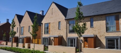
In the case of sites allocated for development in the new North Hertfordshire Local Plan, proposals should relate sensitively to both their immediate context and the wider character of Baldock, and establish a strong sense of place. Applications for the proposed urban extensions (sites BA1, BA2, BA3, BA4 and BA10) should be subject to an independent design review process with community input. This should be procured by the applicant, and demonstrate how the recommendations of this process have been taken into account.
Trumpington Meadows, Cambridge (image © Grosvenor Ltd.)
Reason for this policy
The National Planning Policy Framework indicates that locally-produced design standards should be used to set clear expectations for the sort of development that will be acceptable in each area. This is particularly important for Baldock, in view of its history and areas of distinctive character, and the scale of development proposed for the town in the new North Hertfordshire Local Plan. It is vital that developments are well-designed and create places that current and future generations can be proud of. This is especially true of the major developments proposed in the new Local Plan, which will require completely new places to be designed – not just individual buildings and streets.
To meet this challenge some Design Guidelines are set out as a separate annex to this plan. These illustrate a number of important design principles which new development should reflect, including common issues such as appropriate building lines, parking arrangements and the use of materials that can reflect and reinforce the character and distinctiveness of the area.
As well as setting out general principles, the Design Guidelines outline additional factors to be considered in the design of the urban extensions proposed in the new Local Plan, and for the two brownfield sites that it proposes for regeneration[10]. The latter are particularly prominent and, in the case of the site at Icknield Way, affects the setting of Baldock conservation area. The relationship between existing and new development will require particularly careful consideration where new development abuts existing residential areas, such as around Salisbury Road, Larkins Close and parts of Clothall Common, to achieve an appropriate visual transition and minimise impacts on existing residents.
The National Planning Policy Framework also encourages the use of appropriate processes for assessing and improving the design of development, such as design review panels that provide an independent, expert, assessment of emerging proposals. Given their size and potential impact on the overall character of Baldock, policy G3 requires that design review is used for the proposed urban extensions to the town. A phased approach to design review is likely to be appropriate, so that its focus is tailored to the stage that each site has reached, and the process should allow for community input in line with national guidance on design[11].
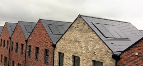
Applications for new buildings or alterations to existing properties that use designs or features to achieve high levels of energy efficiency, resilience to rising temperatures and/or a sustainable use of resources will be supported (for example through their orientation, use of materials or by employing on-site renewable energy generation). Where roof-mounted solar panels are proposed and are not subject to permitted development rights, they should be sited and designed so as to minimise the effect on the external appearance of the building.
Reason for this policy
The new North Hertfordshire Local Plan proposes several policies to secure sustainable forms of development – in particular policy D1 (sustainable design). Policy G4 in the Neighbourhood Plan supplements this, to ensure that specific support is given to proposals that aim to be highly energy efficient, will provide a comfortable living environment as temperatures rise and/or which minimise the environmental impact of their construction.
Minimum standards for the energy performance of buildings and other aspects of their construction are set through building regulations. These have become more stringent over time and are likely to tighten further in the future. Developments can exceed these minimum standards, and proposals within the Neighbourhood Plan area are encouraged to do so. This is particularly important given the amount of new development proposed through the new North Hertfordshire Local Plan, the environmental impact of which should be as limited as possible.
This policy offers support to building designs and features that can help to achieve or exceed national standards. In doing so, proposals should be informed by other policies in the development plan, in particular those relating to other aspects of design, the treatment of historic buildings and Baldock's conservation area.
Various types of microgeneration equipment to produce small-scale renewable energy can be 'permitted development', meaning there is no need to apply for planning permission before they are installed. However, important exemptions and conditions apply. For solar panels, proposals involving listed buildings and their grounds require permission; and where permitted development rights apply there is a requirement that such equipment should, so far as practicable, be sited to minimise its effect on the external appearance of the building involved[12]. Where permission is needed – including as part of proposals for new development – policy G4 ensures that similar considerations apply, so that the visual impact of solar panels is taken fully into account and minimised as much as possible. This can be done in various ways, such as by using solar tiles or ensuring that the colour of panels complements that of the surrounding roof.
Because the planning legislation covering the installation of microgeneration equipment is complex, it is important to get advice from North Hertfordshire District Council before any work is carried out.
Solar photovoltaic panels, St Chads development, Tilbury (image © Photon Energy)
Development within Baldock conservation area, or which affects its setting, should conserve or enhance its character and appearance by reflecting the following principles:
- maintain and reflect the historic pattern of streets, alleys and medieval burgage plots;
- maintain the pattern of continuous built frontages to streets, with mainly wide-fronted buildings and minimal set-backs from the pavement, punctuated by frequent gaps giving access to rear yards;
- avoid obstructing key views of St Mary's Church tower obtained from the High Street, Whitehorse Street, Sun Street, Church Street, Brewery Lane, West Avenue, Letchworth Road and Park Street;
- use building forms and materials that are characteristic of the conservation area – which comprises mainly buildings constructed or re-fronted in classical style during the 18th century, interspersed with some medieval and more recent buildings; a prevailing height of two-three storeys; and a limited palette of materials (mainly red/orange brick, pale render; plain clay tiles and black weatherboarding for subsidiary buildings in rear yards);
- retain, and where possible restore, historic features such as original fenestration, boundary walls and chimneys; and
- use shopfront designs and signage that reflect the style of the building and the character of the wider conservation area.
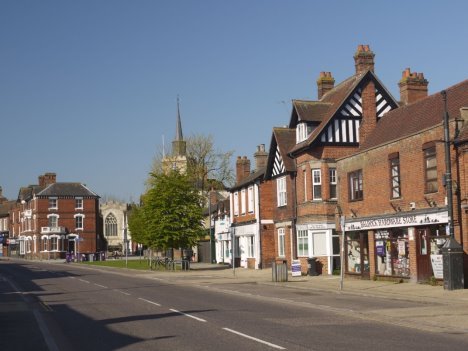
Whitehorse Street, part of Baldock's conservation area
Reason for this policy
Baldock's conservation area is central to the town's character. It embraces the layout of the medieval market town, and the Georgian architecture that reflects its later prosperity as a coaching town on the Great North Road, and as a centre for malting and brewing. Further analysis of its architectural and historic character is contained in the Character Statement for Baldock Conservation Area and the North Hertfordshire Urban Design Assessment[13].
The law requires that planning decisions pay special attention to preserving or enhancing the character or appearance of conservation areas, in recognition of their particular value. Policy G5 supplements the general policies for the historic environment in the new North Hertfordshire Local Plan, by providing more specific guidance related to the particular character of Baldock conservation area. It does not preclude the use of high quality modern design where its form and use of materials respect and complement the character of the conservation area, but such designs will need particularly careful consideration so that they conserve or enhance their surroundings.
The tower of St Mary's church is Baldock's most prominent landmark, and visible from a large number of locations within and beyond the conservation area and the town itself. A number of views make a particularly important contribution to the character of the conservation area, and should not be obstructed. The streets from which these views are obtained are named in policy G5, and the general location of the key viewpoints is illustrated in Figure 4[14].
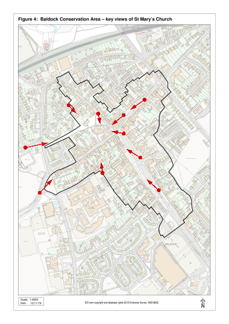
Key
Conservation Area:
Key viewpoints: 
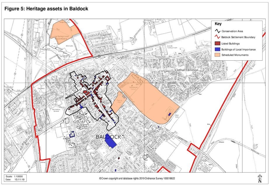
Policy G6 Local heritage assets
Development proposals that would affect the character or setting of a heritage asset of identified local importance should:
- seek to conserve or enhance those qualities and features that make it of value; and
- be supported by an assessment of the potential impact on these qualities/ features, commensurate with the scale of the works and their likely significance for the asset's value.
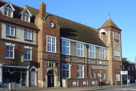
The former Town Hall and No.2 High Street – two buildings of local importance
Reason for this policy
Baldock contains a number of buildings that are not designated as being of national importance, but which have been identified as being locally significant. This may be due to their historic or architectural interest, their contribution to the wider character of the town, or a combination of these. They make an important contribution to Baldock's distinctiveness and sense of history, so it is important that development recognises and respects this.
Policy HE3 in the new North Hertfordshire Local Plan seeks to prevent harm to (or loss of) these buildings, unless the harm or loss can be justified. Policy G6 in the Neighbourhood Plan complements this, by creating a positive expectation that proposals affecting local heritage assets should seek to conserve or enhance their special qualities, and be informed and justified by an understanding of their value.
North Hertfordshire District Council maintains a register of buildings of local importance in Baldock[15], to which Policy G6 applies. The policy also applies to the remains of the garden at Quickswood Farm, to the north of Clothall. These have been identified by the Hertfordshire Gardens Trust as being of significant historic value, sufficient to justify their inclusion on a local list of heritage assets[16].
Similar registers have not been prepared for the parishes of Bygrave and Clothall, but should this occur then the application of the policy would extend to these registers as well, as it would to any further historic gardens that are identified as being sufficiently important to merit protection.
[3] Markides Associates for NHDC (2018) North Hertfordshire District Council Parking Strategy Review – Phase 2 Report – Draft.
[4] This is also an identified employment area in the saved policies from the existing District Local Plan No.2 With Alterations.
[5] WYG for Hertfordshire County Council (2017) Baldock North: Transport Assessment.
[6] Urban Practitioners for NHDC (2007) North Hertfordshire Urban Design Assessment: Baldock.
[7] This comprises relevant parts of the Walls Field scheduled monument and the adjoining 'urban open land' between sites BA2 and BA3 proposed in the new North Hertfordshire Local Plan, as shown in Figure 3.
[8] Land Use Consultants for NHDC (2009) North Hertfordshire District Green Infrastructure Plan. This study also identifies the importance of views from this area to the countryside beyond.
[9] Ministry of Housing, Communities and Local Government (2019) National Planning Policy Framework, paragraph 194.
[10] Land at Icknield Way (site BA6) and Deans Yard, South Road (BA11).
[11] MHCLG (2019) Planning Practice Guidance – Design: Process and Tools.
[12] Further information is available on the Planning Portal web site: https://www.planningportal.co.uk/
[13] NHDC (2003) Character Statement for Baldock Conservation Area; and Urban Practitioners for NHDC (2007) North Hertfordshire Urban Design Assessment: Baldock.
[14] This map is indicative and does not form part of the adopted policies map. The impact of specific development proposals on key views of St Mary's Church tower will need to be subject to individual assessment.
[15] NHDC (2003) Register of Buildings of Local Importance in Baldock. The buildings on the register at the time of preparing this plan are listed in Annex C and illustrated in Figure 5.
[16] Further information is available in Dalton, C. (2007) The Gardens at Quickswood, the Hunting Lodge of the Earls of Salisbury in Hertfordshire Garden History: a Miscellany (ed Anne Rowe).