Baldock, Bygrave & Clothall Neighbourhood Plan - Submission Version
Policies for specific sites
Applications to develop sites BA1, BA2, BA3, BA4 and BA10 proposed in the new North Hertfordshire Local Plan should not be permitted if, taking into account proposed mitigation, the residual cumulative impact on the local road network would be severe (which would include the Whitehorse Street/Station Road crossroads operating significantly above its design capacity); or if national Air Quality Objectives would be breached.
To minimise the risk of increased congestion and/or air quality deterioration within Baldock, applications for these sites should provide for or contribute towards:
- walking and cycling routes that allow safe and convenient access between the sites and Baldock town centre, railway station, employment areas and primary and secondary schools (including any off-site improvements made necessary as a result of the developments);
- the introduction of bus services (or additions to existing routes/stops) once an appropriate scale of development has been reached, to provide access to the town centre and railway station;
- information for new residents/business occupiers on sustainable travel options;
- parking arrangements and the necessary infrastructure to allow convenient charging of electric vehicles;
- measures to help divert traffic away from the Station Road/Whitehorse Street crossroads, such as through appropriate junction designs, access arrangements (including restrictions on heavy goods vehicles), signalling and signage; and
- monitoring of NO2 and fine particle concentrations at this crossroads, in Hitchin Street and at any other locations in Baldock where there could be a risk of significantly increased traffic flows and national Air Quality Objectives being breached, to inform additional or accelerated actions to promote sustainable transport or manage traffic flows, if required.
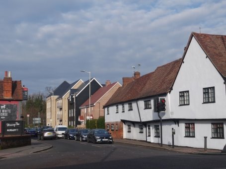
The Station Road/Whitehorse Street crossroads
Reason for this policy
Although the opening of the Baldock bypass in 2006 provided partial relief from through traffic, the benefit was not universal. In North Road and Hitchin Street traffic increased[17], many heavy goods vehicles have continued to take the shortest route through the town, and parts of Baldock still suffer from congestion. The Whitehorse Street/Station Road crossroads is a significant bottleneck that operates at or above capacity[18], and causes frequent delays to traffic, particularly from the north. The volume of traffic using the crossroads also harms the setting of several listed buildings that surround it.
A further consequence of high traffic volumes within Baldock is the risk of poor air quality around some roads, particularly in the Whitehorse Street/Hitchin Street area. While current nitrogen dioxide (NO2) levels are within the level set by the relevant national Air Quality Objective, they would deteriorate over coming years without action to mitigate the impact of the developments being proposed in the new North Hertfordshire Local Plan. In addition, there has been no monitoring of fine particulate matter in Baldock, which is linked to vehicle emissions[19].
The evidence prepared to support the proposed development of these sites anticipates that new link roads and junction improvements will mitigate the impact of additional traffic on the Whitehorse Street/Station Road crossroads[20]. However, as experience with the bypass has shown, the impact of road improvements can be difficult to predict, as it relies on assumptions about trip rates and distributions, and wider factors such as changes in vehicle fuels and usage. In this context it is appropriate to require additional measures, beyond those already proposed in the new Local Plan, to minimise the risk of unacceptable impacts on congestion and emissions, and to monitor impacts as the developments are implemented (allowing further measures to be pursued if needed, as set out in part (f) of the policy).
This is particularly important for sites BA2, BA3, BA4 and BA10, for which the new Local Plan proposes very few specific requirements relating to sustainable travel[21]. These, like site BA1, will result in additional pedestrian and cycle movements to other parts of the town, so should contribute to appropriate off-site improvements. The introduction of bus services – if necessary with some initial financial support from the developments – is particularly important for site BA1; not just to assist those with limited mobility, but also because significant parts of the site are more than 20 minutes' walk from the town centre and/or beyond a ten minute cycle ride[22].
Policy E2 Green infrastructure and outdoor recreation
Applications to develop sites BA1, BA2, BA3, BA4 and BA10 proposed in the new North Hertfordshire Local Plan should provide for an appropriate amount and range of publicly accessible green infrastructure which complies with or exceeds North Hertfordshire District Council's standards (including spaces for children and young people, outdoor sport, allotments and informal recreation). In making this provision the applications should take into account existing needs for green infrastructure within Baldock, Bygrave and Clothall, and should:
- create an integrated network of open spaces and semi-natural areas that provides net benefits for both people and nature, reflects the wider landscape character of the area, improves tree cover and connects with existing green corridors and public rights of way within and beyond the sites;
- ensure that sustainable drainage features such as attenuation basins and swales are designed as an integral part of the overall landscaping scheme, are safe and attractive, and have clear management arrangements agreed prior to permission being granted;
- incorporate street trees to enhance the environmental quality of the developments and provide shade;
- take a strategic approach to locating land for sport and informal recreation, so that the most appropriate sites for each purpose are used (taking into account the allocations as a whole, as well as neighbouring land within the applicant's control where this would accord with other policies in the development plan);
- reflect the most up-to-date evidence available about local needs for pitches and other formal sports provision, including any off-site contributions that may be appropriate[23];
- design new school sports facilities to allow for appropriate community use, supported by community use agreements;
- ensure that new areas for play and recreation are overlooked where this will promote the safety of children and other users (and is designed so as not to have an unacceptable impact on occupiers), and that any external lighting avoids glare to surrounding properties; and
- demonstrate how new green infrastructure will be delivered and managed during both the development phase and beyond, including appropriate arrangements for involving the local community in the design and operation of new facilities.
Reason for this policy
Suitably located and designed green spaces and recreational facilities play a vital role in creating places that are attractive, healthy and which benefit the environment (including by helping to mitigate and adapt to climate change, such as through increased tree cover). It is important to supplement the general policies for securing green infrastructure in the new North Hertfordshire Local Plan, so that Baldock's expansion is guided by specific requirements that reflect the scale of proposed development, local needs and appropriate advice.
The most recent assessment of green infrastructure within Baldock shows an existing deficiency in 'amenity' green space compared to North Hertfordshire's standards[24], while the proposed growth of the town will generate a substantial additional requirement for outdoor spaces of different types. Although the new Local Plan proposes development on a number of different sites at the edge of Baldock, these need to be considered together so that the best sites are chosen for different types of green infrastructure – an approach which is made possible by the fact that all the sites (and some neighbouring land) are owned by Hertfordshire County Council. A strategic approach is particularly important for outdoor sports provision, due to the specific requirements that exist in terms of the size/layout of spaces and need for supporting facilities.
The Government's National Planning Policy Framework makes clear that opportunities for environmental 'net gains' should be sought through the planning system. The combined scale of the proposed urban extensions to Baldock provides an opportunity to put this principle into practice: it should be possible to create a network of multifunctional green infrastructure that offers an enhanced range of recreational facilities for the town and neighbouring villages, as well as enriching and diversifying habitats for wildlife. Particular care will be required in designing sustainable drainage systems as part of this network so that these benefits are realised, taking into account the SuDS Design Guidance for Hertfordshire and industry best practice[25].
New and expanded school provision could help to meet some of the additional sports requirements generated by the proposed developments, but should not be relied upon to meet all of those requirements, given the limited hours during which school facilities can be made available for wider community use, and the need to avoid over-use of school pitches. In addition, Sport England has recommended that financial contributions towards enhancing off-site provision are likely to be the most appropriate way of meeting additional demand for certain sports, where this can improve existing facilities that serve Baldock and/or the additional population could not sustain a new facility within the town.
In applying this policy, it will be appropriate to take into account North Hertfordshire District Council's standards for open space[26]; the Green Infrastructure Plan for North Hertfordshire[27], which provides specific advice on green infrastructure opportunities in and around Baldock (as well as more general principles that may be relevant); and North Hertfordshire's Playing Pitch Strategy Action Plan[28].
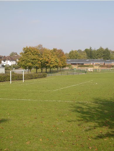
Hartsfield School
Policy E3 Managing construction impacts
Applications to develop sites BA1, BA2, BA3, BA4 and BA10 proposed in the new North Hertfordshire Local Plan should ensure that the impact of construction activity on Baldock, Lower and Upper Bygrave and local roads is minimised through:
- the use of vehicle routes that take construction activity away from existing residential areas and minimise the risk of additional congestion within the town (making use of the proposed link roads associated with these sites so far as possible);
- suitable measures to monitor and manage noise, vibration and dust for the duration of the works (including limiting the hours of operation), and to limit off-site construction waste disposal; and
- the early implementation of landscaping measures where these will provide appropriate screening.
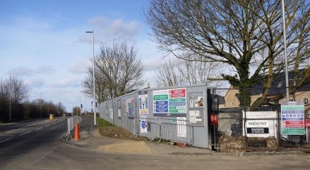
Construction site, Fairfield
Reason for this policy
Construction work on the sites proposed in the new North Hertfordshire Local Plan is expected to take many years – especially on those at the edge of Baldock where new infrastructure such as roads will need to be put in place. To minimise the impact of this work on the existing communities, it is important that suitable mitigation measures are considered and agreed at an early stage. Conditions are expected to be attached to permissions on these sites to ensure that the measures needed are implemented at appropriate points during the construction phase.
Policy E4 Building strong communities
Applications to develop sites BA1, BA2, BA3, BA4 and BA10 proposed in the new North Hertfordshire Local Plan should demonstrate that they have been informed by a process of active engagement with local people, and should include measures to encourage and support the creation of strong and inclusive communities by:
- involving both existing and new (recently arrived) residents in early discussions about the design of each phase;
- providing new community facilities that are required as early as possible in the development process – including the use of temporary facilities where these can provide an interim service before more permanent provision can be made; and
- making arrangements for new residents and businesses to be involved in the continuing management and evolution of their community.
Reason for this policy
Development on the scale proposed in the new North Hertfordshire Local Plan will mean changes in Baldock's size, facilities and feel over a period of many years. It is important that local people have opportunities to influence this process, so that local ideas and preferences can be reflected as much as possible, and the expanded town retains and builds on Baldock's strong sense of community. Involving new residents and businesses will be just as important for this as engaging fully with the existing community.
The early availability of facilities to serve the proposed developments at the edge of Baldock is a particular concern highlighted during initial consultations to produce this plan. This is important not just to avoid placing additional pressure on existing services, but also because of the vital role that accessible local services play in creating new neighbourhoods (through the opportunities they provide for meeting day to day needs, as well as being places to meet).
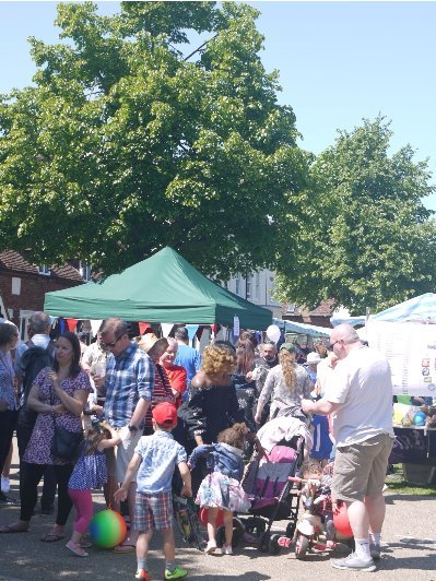
Baldock Street Fair
Successful large-scale developments tend to be characterised by active community involvement in their long-term management[29]. Some aspects of this can be provided for at the application stage, such as the arrangements proposed to manage new recreational facilities and sustainable drainage features. However, some developers have realised the benefits of going further, and invest proactively in building new communities (e.g. by initiating and supporting community events). This is particularly valuable where schemes will take some years to realise, meaning the developer needs to build and maintain a long-term relationship with a community as it evolves. Efforts to support the social development of Baldock will, therefore, be encouraged alongside specific measures that may be agreed as part of any planning approvals.
Policy E5 Development north of the railway
The development of site BA1 proposed in the new North Hertfordshire Local Plan should:
- maintain a clear visual and physical gap between the expanded edge of Baldock and Lower Bygrave, of sufficient size to integrate development into the surrounding landscape and ensure a sympathetic transition towards Lower Bygrave[30];
- incorporate appropriate planting at the periphery of the new development (using a suitable variety of native species, with the mix and density of planting being varied to create a natural appearance);
- minimise adverse visual impacts on longer-distance views towards Baldock from Bygrave[31], by giving careful consideration to the positioning and height of development, as well as to appropriate screening;
- relate sensitively to the edges of existing residential areas where the site abuts them, reflecting section 3.3 in the accompanying Design Guidelines;
- retain and incorporate existing landscape and built features that contribute to the site's history and character, including Bygrave Road/Ashwell Road, the existing houses on Bygrave Road, trees and hedgerows (while safeguarding the habitat value of the Bygrave Road local wildlife site);
- make provision for improved pedestrian and cycle access between Bygrave and Baldock, through a new footpath and cycleway using the route of Bygrave Road/Ashwell Road, designed in a way that maintains as much as possible of its rural character and habitat value;
- minimise the potential for increased traffic flows through Lower and Upper Bygrave, by providing for an appropriate package of measures such as: suitable access arrangements (including restrictions on heavy vehicles); physical features such as gateways and appropriate road surfaces; speed limits and signage); and
- make provision within the site for indoor community facilities suitable for meetings of local groups (such as Bygrave Parish Council and scouts/guides), and for additional indoor recreation facilities to serve the expanded town, with sufficient capacity to meet the additional needs generated by the development.
Reason for this policy
Site BA1 is contained largely within Bygrave parish, and will have a significant impact on the relationship between Baldock and Bygrave, as well as on the character and function of Baldock itself. Policy E5 builds on policy SP14 in the new North Hertfordshire Local Plan by providing additional safeguards, so that Bygrave village retains its separate identity, the character of the site and the relationship with Baldock are taken fully into account, and necessary new facilities are secured.
Bygrave village will remain in the Green Belt, and it is important that a meaningful gap between Lower Bygrave and Baldock is retained to prevent coalescence, integrate new development into the surrounding landscape and limit the extent to which site BA1 is perceived to encroach upon the countryside. A narrow gap would not achieve this, as it would need to rely on dense planting to secure adequate screening and fail to retain a sense of Lower Bygrave as a separate settlement within a rural setting. A landscape and visual appraisal carried out for the Neighbourhood Plan[32] indicates that a gap of at least 170m (corresponding to the 80m contour line, at the point that new development would come closest to Lower Bygrave) is the minimum necessary to secure appropriate screening and landscape integration.
Taking into account indicative masterplans that have been produced for the site, a gap of 170m should be possible to achieve without reducing the overall developable area[33]. However, the appraisal also shows that a 250m gap would be more effective in maintaining longer-distance views of the landscape from Lower Bygrave, and a sense of separation between Baldock and Bygrave.
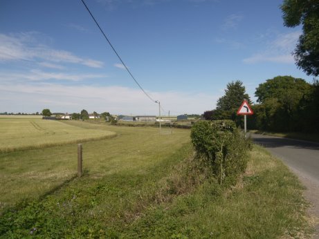
Bygrave Road, with part of site BA1 proposed in the new North Hertfordshire Local Plan
Appropriate screening of site BA1 will also help to maintain a sense of separation, and additional guidance on a suitable approach to planting is set out in North Hertfordshire's Green Infrastructure Plan[34].
Views of the wider countryside from Bygrave are an important feature of the village. It will be important to conserve these longer-distance views so far as possible as Baldock expands, and to mitigate any adverse impacts. Policy SP14 in the new Local Plan already requires built development to be contained to the south/south-west of the ridgeline that runs east from the A507 towards Bygrave, and planting to integrate it into the wider landscape. However, the arrangement and height of development within the site will also affect long-distance views, and should be taken into account in the detailed design of the scheme.
The proposed development of site BA1 is likely to bring new housing close to the existing residential area around Salisbury Road and Larkins Close in Baldock. To minimise the impact on existing residents, the edge of the new development in this area will require particularly careful treatment, some principles for which are set out in the Design Guidelines that accompany this plan.
Much of site BA1 comprises an open field system with a relative lack of visible historic features[35], but those features which are present are important to retain and incorporate sensitively within the development, in view of their historic or environmental importance. The Green Infrastructure Plan notes the importance of Bygrave Road/Ashwell Road as a green corridor, with part of the road being a designated local wildlife site. Some 90% of responses to the Neighbourhood Plan survey thought it was important or very important that such features are kept as part of the new development. Most of the houses on Bygrave Road that lie beyond the current edge of Baldock are also distinctive features, being remnants of the County Council's Rural Estate that provided smallholding opportunities to returning servicemen following the First World War.
The new Local Plan requires a range of facilities to be provided on site BA1 so that many of the day-to-day needs of its residents can be met, including new schools, a GP surgery, shops and a community hall. The parish of Bygrave has no indoor community facilities at present, other than the parish church, but its population will expand considerably once the proposed development of site BA1 gets under way. Therefore, it is important that the community space (or spaces) to be provided is suitable for the needs of local groups including the Parish Council, and provides sufficient capacity and flexibility to meet the range of needs likely to be generated by the proposed development.
In view of its impact on both Bygrave and Baldock, the development of site BA1 should make some further contributions towards improving facilities (over and above those specified in the new Local Plan), to help make the development acceptable in planning terms. The new Local Plan does not make specific provision for additional recreational facilities, despite evidence that both outdoor and indoor facilities serving Baldock are either lacking or already at capacity[36]. New green infrastructure – including land for outdoor sport – is addressed through policy E2 in this plan. In addition, site BA1 should as a minimum provide additional sports hall facilities that are suitable for community use, which could be through multi-use of the proposed schools facilities. Fitness suite/activity studio facilities could also form part of this provision.
The proximity of the proposed development to Bygrave village is also likely to generate more pedestrian or cycle trips from the village into Baldock, so a suitable footpath/ cycleway between the two – using the route of Ashwell Road/Bygrave Road – should also be provided. This would help to maintain this historic route between Baldock and Bygrave, but would need to be done in a sensitive manner that maintains as much as possible of its rural character and habitat value. It may be possible to maintain limited vehicular access along this route, but this will depend on the detailed network design and masterplanning for the proposed development.
There is concern within Bygrave about the potential for site BA1 to generate many more traffic movements through the village, which could have a significant impact on its character and tranquillity[37]. While access to Ashwell from Baldock and Bygrave will need to be retained, every effort should be made to minimise the number and speed of vehicle movements through Bygrave as site BA1 is developed. Consequently, contributions will be required towards a suitable package of traffic management measures. These should be appropriate to the rural character of the village, by avoiding features that would have an urbanising effect and keeping signage to a minimum.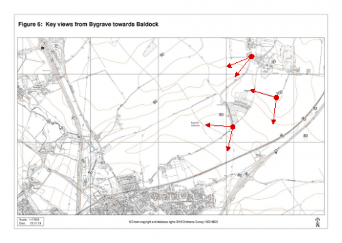
Note: this map does not form part of the adopted policies map.
The development of sites BA3, BA4 and BA10 proposed in the new North Hertfordshire Local Plan should:
- create a high quality and distinctive entrance to the town along Royston Road, using well-designed buildings and a consistent approach to landscaping and lighting;
- relate sensitively to the existing houses fronting onto Royston Road through the scale, massing and landscaping of the new development;
- incorporate a landscape buffer between development on site BA10 and the railway line, and use building materials and colours that will help to soften the visual impact of the development in both near and long-distance views (which could include the use of green roofs); and
- make provision for an improved footpath and cycleway along Royston Road.
Any applications for the redevelopment of existing commercial units on existing employment site BE2 should also reflect this policy.
A landscaping strategy for Royston Road should be agreed with North Hertfordshire District Council before relevant applications for reserved matters consent on sites BA3, BA4 and BA10 are approved.
Reason for this policy
The developments proposed in the new North Hertfordshire Local Plan will have a significant effect on the character and appearance of Royston Road. It is important to ensure that these schemes are implemented in a way that enhances Royston Road's appearance, as this is one of the main routes into the town, and currently there is a fragmented pattern of development and barriers to movement between Clothall Common and other parts of Baldock. The relationship between commercial and residential uses will also require particularly careful treatment to ensure satisfactory living conditions for existing and future occupiers.
Royston Road
This requires a coordinated approach to the proposed developments, which will allow opportunities to enhance the appearance and accessibility of this corridor through the design of the buildings, landscaping and other infrastructure. Establishing an appropriate landscape framework for Royston Road at an early stage will help to ensure that this coordinated approach is realised, and is made more practical to deliver by the fact that the sites are in single ownership (Hertfordshire County Council).
The Landscape Sensitivity Study for land to the north of Baldock, and the North Hertfordshire Green Infrastructure Plan[38], highlight the potential prominence of development in this part of Baldock, and suggest appropriate mitigation measures through appropriate landscaping and building design. They also highlight the scope to enhance the ecological value of the railway corridor by creating a green buffer alongside it.
There is scope to improve the appearance of the Ashville Trading Estate (employment site BE2 in the new Local Plan) over time, as proposals to redevelop existing units come forward[39]. Applying policy E6 to such proposals will help to ensure that they contribute to the wider opportunities for improving the appearance of Royston Road.
Policy E7 Cambrai Farm and south of Clothall Common
The development of sites BA2 and BA3 proposed in the new North Hertfordshire Local Plan should:
- incorporate a landscape buffer between the edge of the developments and the Baldock bypass, using an appropriate mix of native species, to provide visual screening, an enhanced green corridor and noise attenuation;
- avoid new buildings on that part of BA3 that comprises raised land to the east of the existing properties on Aleyn Way and Merchants Walk, and to the south of Royston Road[40], which should be retained and enhanced as space for informal outdoor recreation; and
- reinforce the planting between Hillside Park mobile home site and new residential development on site BA2, to provide a stronger green margin and additional screening, using an appropriate mix of native species.
Proposals to provide additional indoor and outdoor community facilities, suitable for use by children and young people, in association with these developments will be supported.
Reasons for this policy
Sites BA2 (Cambrai Farm) and BA3 (south of Clothall Common) both occupy prominent positions at the eastern edge of Baldock, within Clothall parish. Development on both sites will affect views from a number of locations within Baldock, and the Green Infrastructure Plan[41] has identified the need for careful treatment of the site boundaries to limit their visual impact. Policy E7 supplements the measures proposed in the new North Hertfordshire Local Plan, in particular to ensure that other sensitive boundaries to these sites incorporate appropriate landscaping and screening.
Site BA2 to the left, part of BA3 at mid-right, and BA1 in the distance
Development bordering the Baldock bypass could be particularly intrusive, both from the road itself and from adjoining public rights of way, so it is particularly important that a soft edge is provided in these locations. This should be implemented in a way that supports necessary levels of noise reduction for new properties, as well as achieving visual screening.
The more elevated, northern parts of site BA3 serve an important purpose as a large area of informal open space created after the construction of the Baldock bypass, and the need for this recreational use is expected to increase once sites BA3 and BA4 proposed in the new Local Plan are developed. Currently the visual quality of this land is relatively poor, and could be enhanced through measures such as additional planting.
Figure 7: Location of raised land to the east of Aleyn Way and Merchants Walk
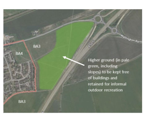
Imagery © 2019 Google This map is indicative and does not form part of the adopted policies map.
New buildings on this part of the site would not be appropriate, and not just because of the potential impact on its recreational value. The land rises relatively steeply to the east of Aleyn Way and Merchants Walk (apart from a corridor at the foot of this slope[42]), so buildings on the raised land would not be sympathetic to the surrounding built environment and landscape setting. This would also be true if the slopes rising up to the raised land were to be used or excavated to accommodate development. The raised parts of the site are also potentially unsuitable for building, as they were formed by spoil deposited during the construction of the bypass.
While the new North Hertfordshire Local Plan and policy E5 in this document require new community facilities to be provided as part of site BA1, these are unlikely to be built for some years (if, as expected, site BA1 is developed after the other major sites proposed in the new North Hertfordshire Local Plan). The new Local Plan does not propose any new community facilities in association with the other sites that it allocates for residential development, even though they are likely to put increased pressure on existing facilities.
This is a particular issue for community spaces: while there may be some scope to make more intensive use of the halls that currently exist in Baldock, there is a shortage of facilities that provide suitable indoor and outdoor space for groups such as after-school clubs and scouts/guides. There is an opportunity to provide such a facility as part of the proposed development of sites BA2 and BA3, potentially making some use of part of the 'urban open land' between these sites proposed in the new Local Plan for any outdoor recreation element.
[17] Report to Hertfordshire County Council's Highways and Transport Panel, 15 November 2007: Baldock Bypass: One Year On.
[18] WYG Transport Planning for Hertfordshire County Council (2017) Baldock North: Transport Assessment.
[19] NHDC (2017) Baldock Air Quality Paper. For information on the national Air Quality Objectives see https://uk-air.defra.gov.uk/air-pollution/uk-eu-limits
[20] AECOM for NHDC (2016) Technical Note: Preferred Local Plan Model Testing Including Baldock Link Roads; and WYG Transport Planning for Hertfordshire County Council (2017) Baldock North: Transport Assessment.
[21] Promoting more sustainable travel is central to the approach of the latest Local Transport Plan for Hertfordshire: Hertfordshire County Council (2018) Hertfordshire's Local Transport Plan ('LTP4').
[22] Markides Associates for NHDC (2017) North Hertfordshire Transport Strategy.
[23] For example, at the time of producing this plan, Sport England had suggested that provision across the proposed sites – and neighbouring land where appropriate – should include a multi-pitch playing field for community use; an artificial grass pitch and multi-use games area (for tennis and netball) as part of the new secondary school facilities; with off-site contributions towards enhanced provision for rugby and hockey (Sport England comments on planning applications for Baldock North and Baldock South East, 2018).
[24] NHDC (2016) Open Space Review & Standards.
[25] Hertfordshire County Council (2015) SuDS Design Guidance for Hertfordshire and CIRIA (2015) The SuDS Manual.
[26] NHDC (2016) North Hertfordshire Open Space Review & Standards 2016.
[27] Land Use Consultants for NHDC (2009) North Hertfordshire District Green Infrastructure Plan.
[28] KKP for NHDC (2016) North Hertfordshire Playing Pitch Strategy & Action Plan 2015-2025.
[29] For example, see Berkeley Group (2013) Creating Successful Places: A Toolkit.
[30] In practice this will require a gap of at least 170m between the built edge of site BA1 and the nearest property in Lower Bygrave, although a 250m gap would be more effective in delivering these objectives and should be maintained if possible.
[31] Particularly important views exist from the corner of Ashwell Road where it meets Lower Bygrave; from Ashwell Road as it leaves Upper Bygrave, across the valley to the west; and from the junction of footpaths Bygrave 005 and 006 (see Figure 6).
[32] AECOM for Baldock, Bygrave and Clothall Planning Group (2019) Land North of the Railway, Baldock: Landscape and Visual Appraisal
[33] For example, the masterplan prepared for Hertfordshire County Council in support of its initial planning application for the site (application 17/04420/OP) suggests the potential for some reconfiguration of the built area at this eastern end of the site.
[34] Land Use Consultants for NHDC (2009) North Hertfordshire District Green Infrastructure Plan.
[35] Land Use Consultants for NHDC (2013) Land north of Baldock: Landscape Sensitivity Study. The site does include several areas of archaeological interest, which the new Local Plan requires are taken into account in the layout of the development.
[36] KKP for NHDC (2015) North Hertfordshire Playing Pitch Strategy Assessment Report; and KKP for NHDC (2016) North Hertfordshire Indoor Sports Facilities Study Assessment Report.
[37] Other developments proposed in the new North Hertfordshire Local Plan could also contribute to increased traffic through the village, albeit to a much lesser degree; particularly site AS1 at Ashwell, where conditional permission has been granted for 30 new homes.
[38] Land Use Consultants for NHDC: Land north of Baldock: Landscape Sensitivity Study (2013) and North Hertfordshire District Green Infrastructure Plan (2009).
[39] This Neighbourhood Plan has also identified the potential to use a small part of this site as additional parking for Baldock station – see policy G1.
[40] The area of BA3 referred to here is illustrated in Figure 7, and includes the slopes rising up to the raised land.
[41] Land Use Consultants for NHDC (2009) North Hertfordshire District Green Infrastructure Plan.
[42] This corridor of relatively flat land could potentially accommodate a new road as proposed in the new North Hertfordshire Local Plan, but this would need to be carefully designed and landscaped to avoid adverse visual impacts and noise intrusion for both existing residents and users of the open space.